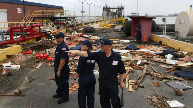
Tracking MARIA
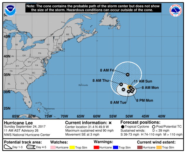
We’re still tracking MARIA in the Atlantic basin and according to NOAA’s NHC, it was a category 2 storm with sustained winds of 105mph as of midday Sunday.
.gif)
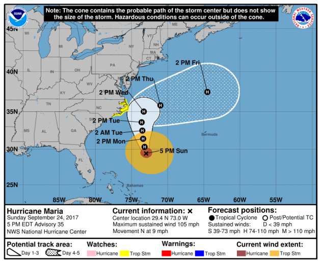
Tracking MARIA
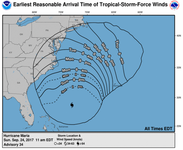
Here’s the official track from NOAA’s NHC, which show the storm generally lifting north-northeast through the week ahead, but note the “cone of uncertainty” fanning out over the next several days. This means that there is still some uncertainty on where MARIA will actually track and could actually be a little closer to the East Coast, which would mean bigger impacts in those areas. With that said, tropical storm watches have been issued for areas in yellow along the eastern part of North Carolina. The good news is that the worst of the wind, rain and high surf will stay offshore.
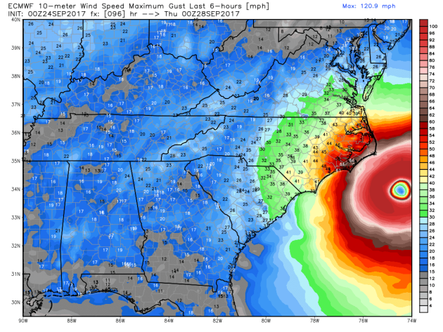
Tracking MARIA – GFS (American Model)
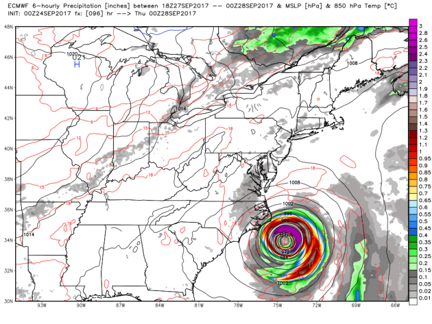
Tracking MARIA – Strongest Wind Gusts PM Wednesday
________________________________________________________
.png)
__________________________________________________________
.png)
.gif)
___________________________________________________________
___________________________________________________________
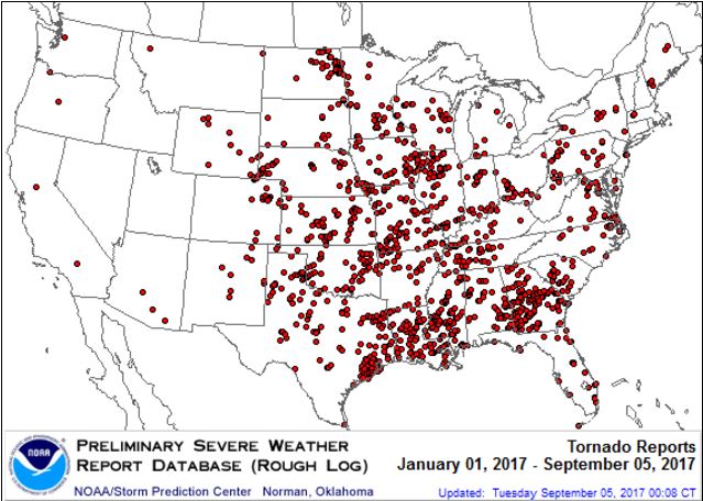
It certainly has been a fairly active first half of 2017 with 1373 preliminary tornado reports through September 22nd. Note that this is the most tornadoes through September 23rd since 2011, when there were 1,784 reports. The map below shows the distribution of the tornadoes so far this year.
PRELIMINARY 2017 Tornado Count
According to NOAA’s SPC, the PRELIMINARY 2017 tornado count is 1373 (through September 22nd). Note that is the most active year for tornadoes since 2011, when there were 1,784 tornadoes. Keep in mind there was a major tornado outbreak in the Gulf Coast region from April 25-28, 2011 that spawned nearly 500 tornadoes, some of which were deadly. That outbreak is known as the Super Outbreak of 2011 and has gone down in history as one of the biggest, costliest and one of the deadliest tornado outbreaks in history.
.png)
_____________________________________________________________________
National Weather Hazards Ahead…
1.) Heavy rain across portions of the Central Plains and Southern Plains, Mon, Sep 25.
2.) Heavy rain across portions of the Southern Plains, Tue-Fri, Sep 26-Sep 29.
3.) High significant wave heights for coastal portions of the Mid-Atlantic and the Northeast, Wed, Sep 27.
4.) Heavy rain across portions of the Alaska Panhandle, Tue-Wed, Sep 26-Sep 27.
5.) Much above normal temperatures across portions of the Northeast, the Central Appalachians, the Mid-Atlantic, the Upper Mississippi Valley, the Great Lakes, and the Ohio Valley, Tue-Wed, Sep 26-Sep 27.
6.) Flooding occurring or imminent across portions of the Southeast.
7.) Severe Drought across the Central Plains, the Northern Plains, Hawaii, the Northern Rockies, the Middle Mississippi Valley, California, the Upper Mississippi Valley, and the Southern Plains.
.png)
_________________________________________________________
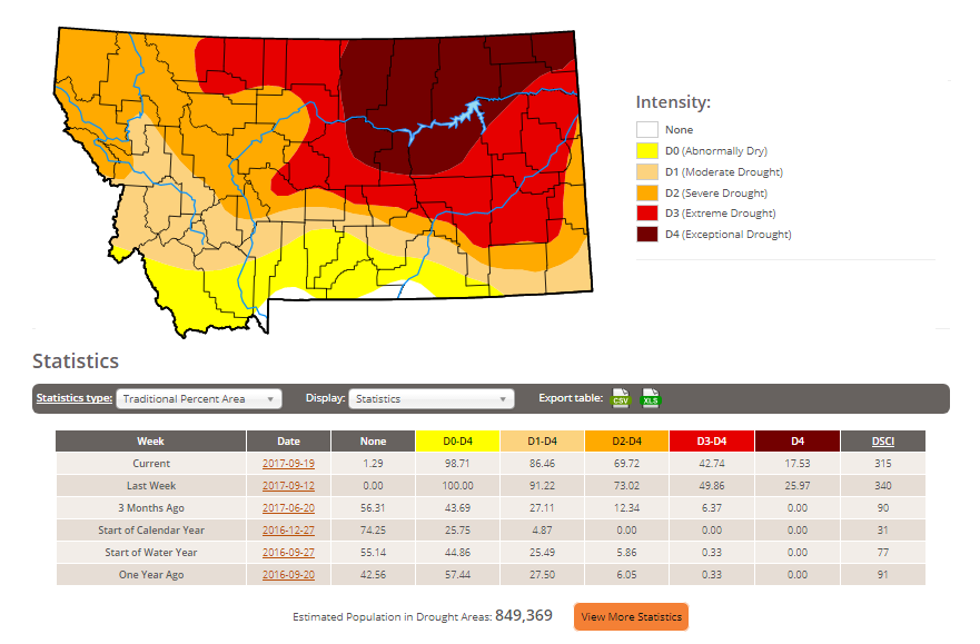
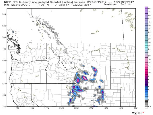
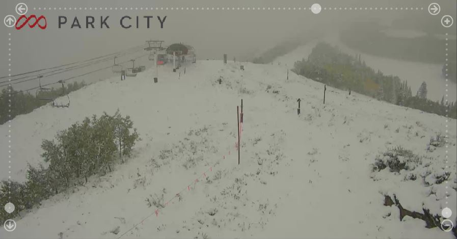
“Rain and snow take aim at the Montana drought”
“The weather this summer has been downright unruly, but it’s ready to make amends. After months of extreme drought and fire, the state is getting some much-needed rain and snow. “We ended up receiving a second round of precipitation, mainly in southwest and central Montana,” Jim Brusda, lead meteorologist with the National Weather Service, said. “It’s pretty welcome because of how dry it has been.” Lewistown is reaping the most benefits from the weather system with .32 inches by Friday afternoon. The east side of the Big Snowies has already received nine inches of snow. The rainfall wasn’t too excessive in Great Falls, where only .18 inches fell, while, approximately .14 inches fell in Helena by Friday afternoon. Other places were worse off, with just a trace, .01 inches, in Cut Bank and nothing in Havre. But every drop of rain is going to good use. Brusda said the soil is absorbing all of the precipitation.”
See more from Great Falls Tribune HERE:

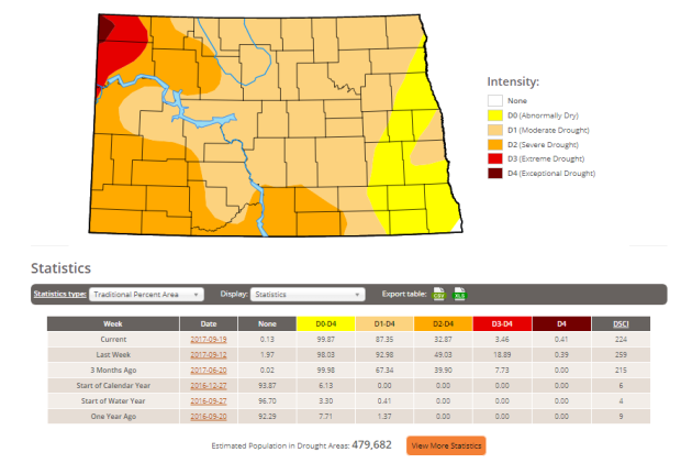
Here’s the latest drought update from the US Drought Monitor, which shows EXCEPTIONAL drought conditions continuing across parts of Montana. Note that nearly 99% of the state is considered to be abnormally dry, but the EXCEPTIONAL drought covers nearly 18% of the state, which is down from nearly 26% last week. In North Dakota, less than 1% is in an EXCEPTIONAL drought, but nearly 3% of the state is still in an EXTREME drought, which is also down from the near 19% last week.
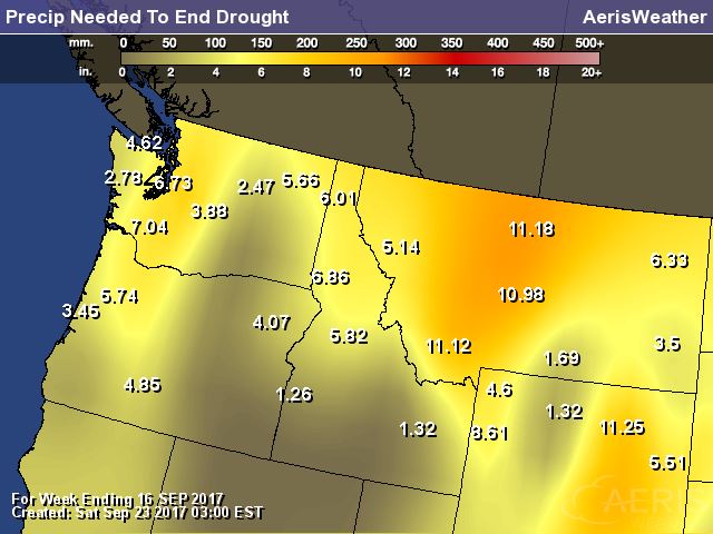
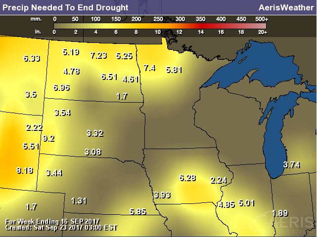
Rain Needed to End Drought
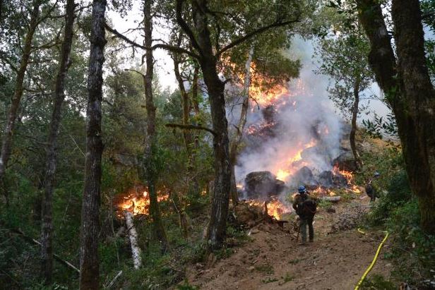
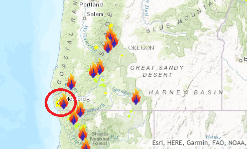
Chetco Bar Fire – 5 Miles Northeast of Brookings, OR
The Chetco Bar Fire near Brookings, Oregon is a very large wildfire in the Western US that started on Wednesday, July 12th by lightning and has grown to more than 191,000 acres! There are nearly 1,200 people working on this fire, which is 97% contained. The estimated containment date is set for Sunday, October 15th.
“Incident Summary: In the past week firefighters have made good progress in containing and strengthening lines around the Chetco Bar Fire. Firefighters, including crews with Oregon Army National Guard Task Force 5, continue to monitor and patrol the fireline, adding waterbars and recovering equipment where where containment objectives have been achieved. The current weather pattern is more favorable for firefighters and the area forecast includes more than an inch of rain in addition to cooler temperatures and higher humidity over the next few days. Evacuations and Closures: All Evacuation Advisories in Curry County and Josephine County have been lifted.”
(Credit: Andy Lyon)
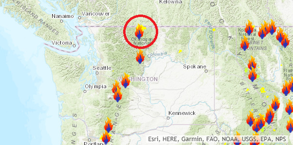
 Diamond Creek Fire – Mazama, Washington
The Diamond Creek Fire near Mazama, Washington is a very large wildfire in the Western US that started on Sunday, July 23rd and has grown to more than 127,000 acres! There are nearly 202 people working on this fire, which is 77% contained. The estimated containment date is set for Sunday, October 15th.
“Incident Summary: The Diamond Creek Fire was reported on July 23, 2017 at approximately 9:45 a.m. The fire is burning in the Pasayten Wilderness and Eightmile drainage about 11 miles north of Mazama, Washington. Smokejumpers responded to the fire within two hours of it being reported. However, due to extreme terrain, heavy dead and down timber, and critical fire weather conditions, the fire was unable to be contained during initial response. The fire crossed into Canada on August 29. Fire managers recognized that the Diamond Creek Fire would likely be a long term event. Monitor, confine and point protection strategies are being used inside the Pasayten Wilderness. Outside the wilderness, the fire is being managed under a suppression strategy using a mixture of direct, indirect and point protection tactics when and where there is a high probability of success. Fire personnel will engage the fire at the appropriate time and location, while keeping public and firefighter safety as the top priority. Fire personnel are currently focused on identifying and implementing suppression repair work on the primary and contingency control lines. The suppression repair will not compromise the intended purpose of the control lines should they be needed at a later date”
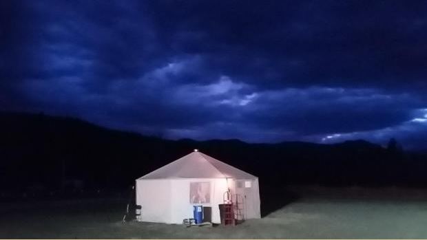
(Night time picture of a glowing yurt Credit: Brent Tannehill)
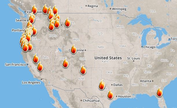
Ongoing Large Wildfires
Here’s a look at the current wildfire map across the country. Continued hot and dry weather has helped to spark several wildfires across the Western US. There have even been fires popping up in the Eastern U.S., two of the larger fires are burning in Florida.
Here’s a list of all the current large wildfires from Inciweb:
National Weather Outlook
Here’s the weather outlook through the early part of the week, which shows a cool front stalling across the central part of the country. This will keep the threat of scattered showers and storms in place with areas of locally heavy rain. Also note MARIA, the tropical system in the Atlantic approaching the East Coast as we head into the early week time frame. This will bring heavy rain, wind and storm surge to places there.
.gif)
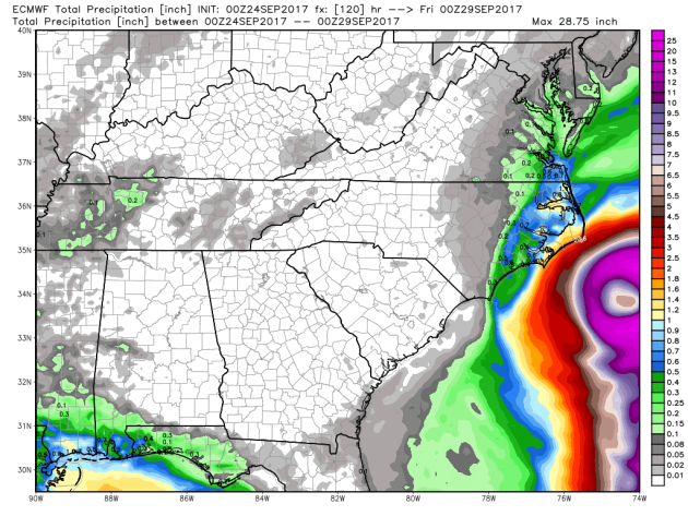
According to NOAA’s WPC, the next several days could produce very heavy rainfall across the Plains with some 4″ to 8″ amounts possible, especially across parts of western Texas. Also note the heavy rain potential just clipping the East Coast, which would be associated with MARIA.
.gif)
By Paul Douglas
This Day in Weather History
September 25th
1998: A wind gust to 78 mph is reported at Staples Municipal Airport, just to the north of Staples in Wadena County. In Todd County, trees are blown down in the city of Staples. Buildings are damaged at a farmstead on the northwest edge of the city. A roof is torn off of Stern Rubber Company, and rooftop heating and cooling units are ripped off McKechnie Tool and Engineering. In Mille Lacs County, 3 inch hail is reported, damaging many automobiles.
1929: Willmar experiences a deluge that produces 5.22 inches of rain in 24 hours.
________________________________________________________
Average High/Low for Minneapolis
September 25th
Average High: 68F (Record: 91F set in 1920)
Average Low: 48F (Record: 31F set in 1926)
Record Rainfall: 1.34″ set in 1934
_________________________________________________________
Sunrise/Sunset Times for Minneapolis
September 25th
Sunrise: 7:04am
Sunset: 7:04pm
Hours of Daylight: ~12hours
Daylight LOST since yesterday: ~3 minutes and 6 seconds
Daylight LOST since summer solstice (June 20th): 3 hours & 37 minutes
__________________________________________________________
Moon Phase for September 25th at Midnight
1.8 Days Before First Quarter
_________________________
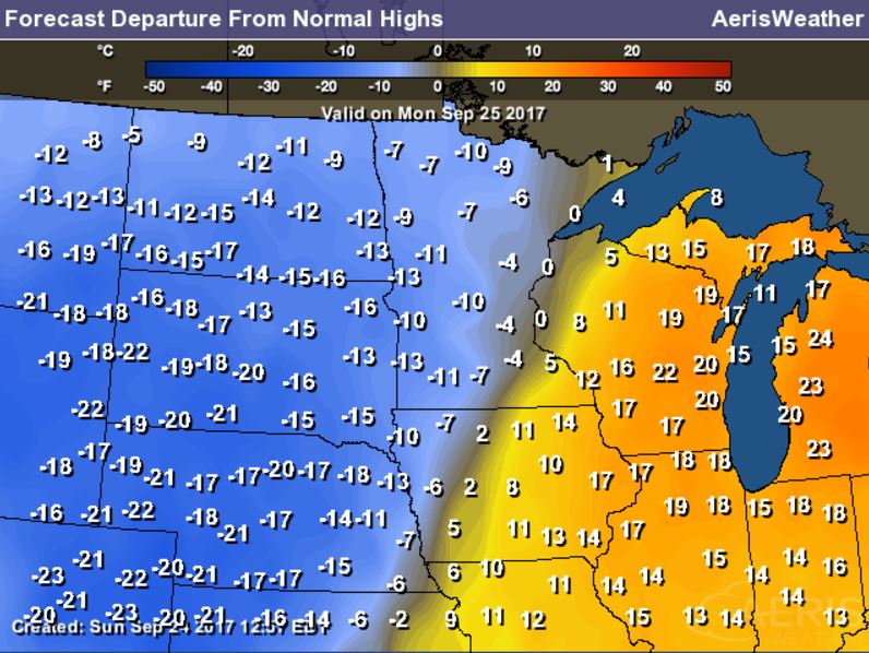
Temperatures on Monday will be quite a bit cooler than it was this weekend as the front slowly shitfs east. Highs in the Twin Cities will be nearly 20F cooler than it was Friday-Sunday as highs slip into the 60s. Note that along the front, temperatures will be closer to average, while temp east and west of the front will be quite a bit warmer and cooler than average.
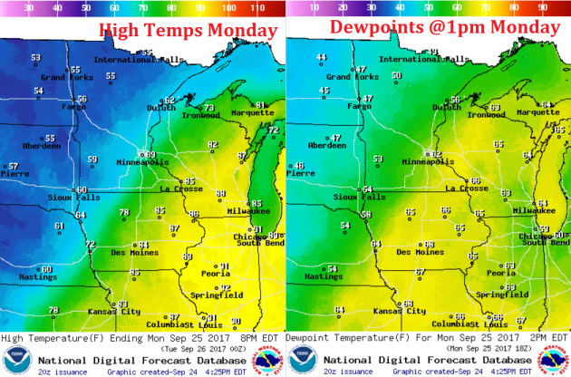
Weather Outlook For Monday
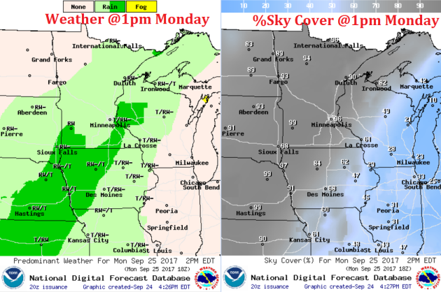
A stalled frontal boundary will continue to slowly shift east with areas of scattered showers and storms, which will likely stick around through the first half of Tuesday.
.png)
______________________________________________________
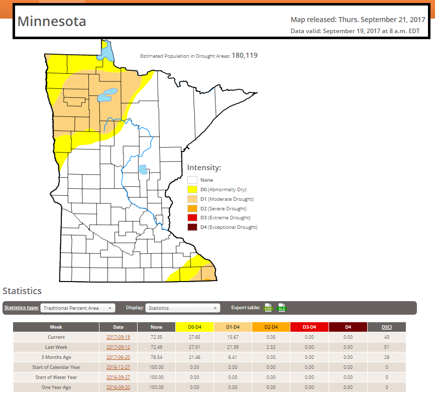
Minnesota Drought Conditions
According to the US Drought Monitor, only 0.05% of the state is considered to be in a SEVERE drought, which dropped from the near 2% last week. Also note that nearly 16% of the state is considered to be in a MODERATE drought, which is also down from the near 21% from last week.
____________________________________________________________________
Minneapolis Temperature Outlook
Here’s the temperature outlook through October 9th, which shows temps cooling significantly from the summerlike weekend we just had. Readings will be more Fall-like as we dip into the 60s and 70s through the early part of October.
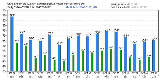
According to NOAA’s CPC, the extended temperature outlook from October 2nd through the 6th suggests warmer than average temperatures possible across parts of the Midwest.
___________________________________________________________
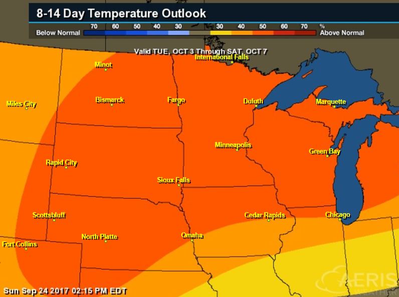
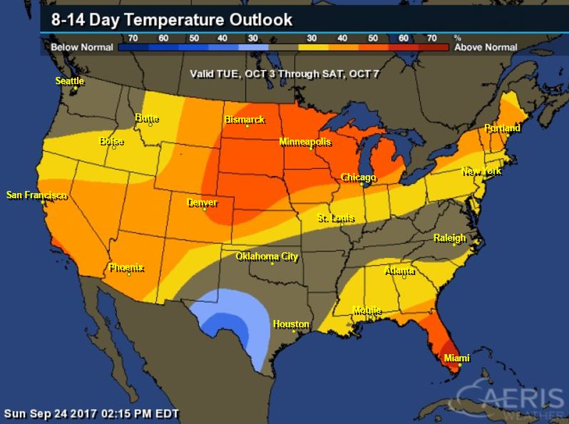
Extended Temperature Outlook
According to NOAA’s CPC, the extended temperature outlook through October 8th shows that a good chunk of the Southern U.S. will be cooler than average, but the Western and Northern US will remain warmer than average.
 __________________________________________________________
Fall Color – Coming To A Tree Near You…
It’s about that time of the year again to gaze upon Mother Nature’s fall foliage, which is really starting to show up. By now, you’ve probably noticed a few eager trees changing color pretty rapidly, some of this could be due to a little stress, but it’s not uncommon to start seeing some changes at this time of the year.

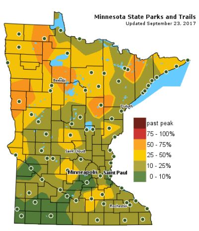
Minnesota Fall Color Update
According the MN DNR, much of the state is already starting to see hints of fall color, however, there are pockets of 50%-75% color across northern Minnesota!
Follow along as the fall colors change with the MN DNR map HERE:
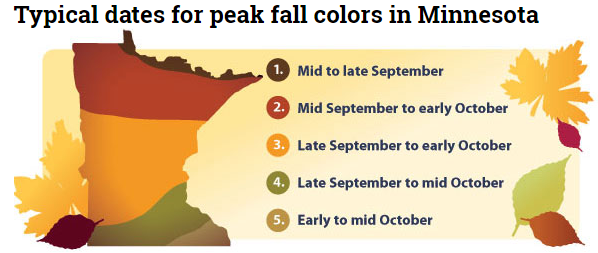
Typical Fall Color Peak in Minnesota
Here are the typical fall color peak times across the state of Minnesota and note that areas along the northern tier of the state usually see their peak toward the 2nd half of September. However, peak color usually doesn’t arrive in central Minnesota until October, but we’re getting close.
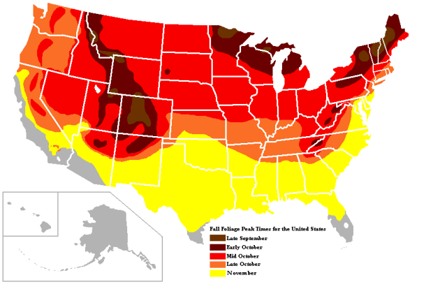
Typical Fall Color Times Across the Country
Here are the typical fall color peak times across the country, which suggests that much of the peak across the northern half of the nation usually wraps up through the month of October.
_______________________________________________________________
_____________________________________________________________________
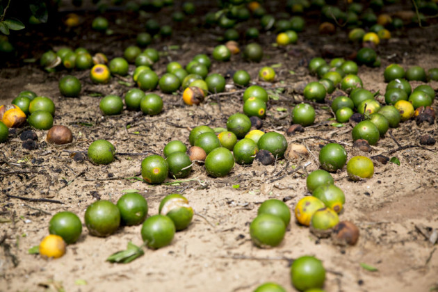
“The most recent estimates of the widespread damage to Florida’s orange trees put the statewide losses as high as 70 percent. Hurricane Irma plundered Florida’s orange belt, leaving a trail of uprooted trees, downed fruit and flooded groves worse than anything growers say they have seen in more than 20 years. It could even be the knock-out blow for a product — orange juice — that has been slipping in popularity among Americans, although the beverage still ranks as the country’s favorite fruit. The most recent estimates of the widespread damage to Florida’s orange trees put the statewide losses as high as 70 percent. That could lead to orange shortages, price hikes and, for farmers, lost harvests — all on top of a debilitating plant disease called citrus greening and a long-term national decline in orange juice consumption. “Significant is not the right word,”said Shannon Shepp, the executive director of the growers’ group Florida Department of Citrus, describing the damage to Florida’s orange juice industry. “It’s somewhere between significant and catastrophic. And that’s a big word — I don’t use it lightly.” It could have implications not only for Florida agriculture, but for the American diet.”
See more from DenverPost HERE:
(Fruit sits on the ground below an orange tree at the Alico Inc. Lake Patrick Grove in Frostproof, Florida, on Sept. 11, 2017. Daniel Acker, Bloomberg via DenverPost)
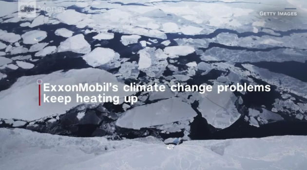
_________________________________________________________________“California cities want Big Oil to pay for costs of climate change”
“Coastal cities in California that are vulnerable to flooding caused by climate change are fighting back against Big Oil. San Francisco and Oakland filed lawsuits this week demanding that ExxonMobil, Chevron (CVX), BP, ConocoPhillips (COP) and Royal Dutch Shell pay billions to cover the costs of sea walls and other protections against rising sea levels. The aggressive strategy from the Bay Area makes San Francisco and Oakland the first major U.S. cities to attempt to shift the costs of climate change from the public to fossil fuel companies. San Francisco and Oakland fear that billions of dollars of property in low-lying areas will be swamped by rising sea levels that scientists blame on climate change. “These fossil fuel companies profited handsomely for decades while knowing they were putting the fate of our cities at risk,” San Francisco City Attorney Dennis Herrera said in a statement announcing the lawsuits, which were filed in Superior Court in San Francisco and Alameda Counties.”
(Image credit: Getty images via CNN.com)
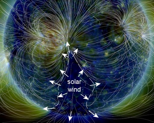
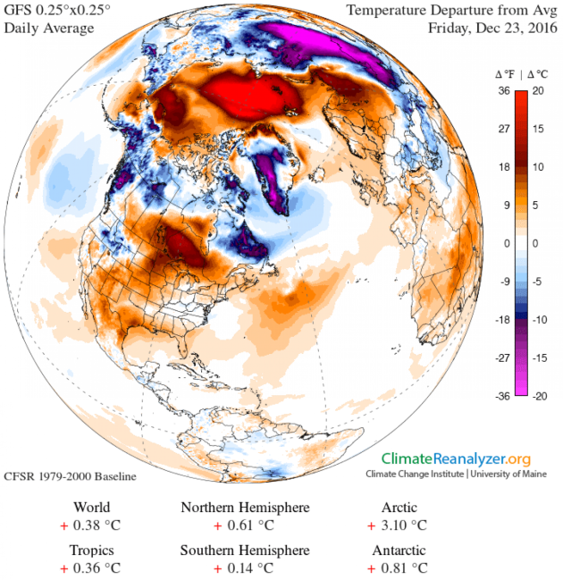
______________________________________________________________“One of the most bizarre ideas about climate change just found more evidence in its favor”
“More and more, we are learning that climate change can lead to some pretty strange and counterintuitive effects, especially when it comes to the wintertime. For instance, scientists have pointed out for a number of years that warmer seas, and a wetter atmosphere, can actually fuel more snowfall in massive nor’easters affecting the U.S. East Coast. More controversial still is an idea called “Warm Arctic, Cold Continents.” This is the notion that as the Arctic warms up faster than the middle latitudes, it may sometimes cause a displacement of the region’s still quite frigid air to places that aren’t so used to it. In other words, even as the planet warms, masses of cold air could also become more mobile and deliver quite a shock at times when outbreaks occur in more southerly latitudes.”
See more from Washington Post HERE:
_________________________________________________________________“NASA’S OSIRIS-REx Spacecraft Slingshots Past Earth”
“NASA’s asteroid sample return spacecraft successfully used Earth’s gravity on Friday to slingshot itself on a path toward the asteroid Bennu, for a rendezvous next August. At 12:52 p.m. EDT on Sept. 22, the OSIRIS-REx (Origins, Spectral Interpretation, Resource Identification, and Security – Regolith Explorer) spacecraft came within 10,711 miles (17,237 km) of Antarctica, just south of Cape Horn, Chile, before following a route north over the Pacific Ocean. OSIRIS-REx launched from Cape Canaveral Air Force Station in Florida on Sept. 8, 2016, on an Atlas V 411 rocket. Although the rocket provided the spacecraft with the all the momentum required to propel it forward to Bennu, OSIRIS-REx needed an extra boost from the Earth’s gravity to change its orbital plane. Bennu’s orbit around the Sun is tilted six degrees from Earth’s orbit, and this maneuver changed the spacecraft’s direction to put it on the path toward Bennu. As a result of the flyby, the velocity change to the spacecraft was 8,451 miles per hour (3.778 kilometers per second).”
(OSIRIS-REx is NASA’s mission to explore near-earth asteroid Bennu, collect a sample, and return it to Earth. To get to Bennu, however, OSIRIS-REx must first leave the plane of Earth’s orbit and match the orbital tilt of its target. On September 22, 2017, OSIRIS-REx approached Earth and flew over its southern hemisphere, passing within 11,000 miles of Antarctica. Credits: NASA’s Goddard Space Flight Center)

_________________________________________________________________
Thanks for checking in and don’t forget to follow me on Twitter @TNelsonWX

