October 19, 2000: Warmest October 19th in Minnesota history. Many cities had highs in the 80s, with the Twin Cities hitting 84 degrees. Appleton in Swift County reported 90 degrees.
October 19, 1972: Cold Snap. 1 above in Tower. 9 in St Peter and Luverne.
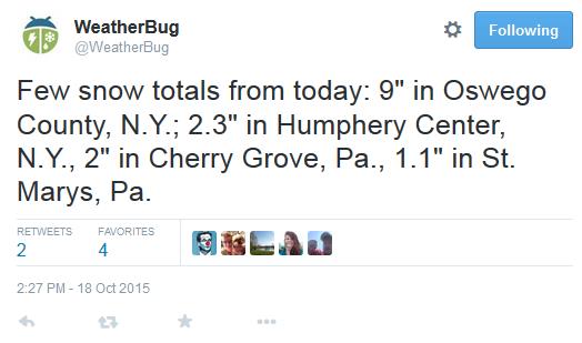
October 19, 1916: Redwood Falls received a record-setting 7 inches of snow.

Warming Trend, Winter May Be Delayed This Year
I don’t know much – but here is what I do know: Google knows me better than I know myself. Computers and cars break down at the most inopportune time. And lip-readers get an entirely different football game on TV.
That, and the Earth is tilted by 23.5 degrees on its axis. During the winter Earth tilts away from the sun; northern latitudes receive only a glancing blow of sunlight. This cools northern latitudes in waves, as longer nights and snow on the ground brew up increasingly frigid air – sent via “airmail” from our friends in Canada.
Game of Thrones assures me that “winter is coming” and I don’t disagree. But a strong El Nino may keep our winds blowing from the west, a milder “zonal” Pacific flow, for more of the winter than usual. Dips in the jet stream will whip up snow and cold fronts but El Nino may take the edge off the most extreme invasions of cold air, deflecting some of the coldest Canadian air into New England. Time will tell.
The maps look more like late September: mid-70s today, otherwise 60s – with rain likely on Friday. Skies clear Saturday – we should salvage another fine fall weekend.
No wintry smacks in sight just yet.
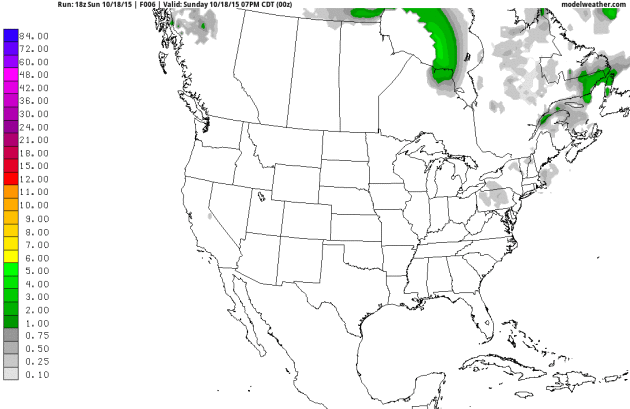
Winter Is Here – In Canada. Here’s the 10-Day accumulated snowfall prediction (courtesy of NOAA’s GFS model). A little slush decorates the top of the peaks in the Rockies, but lake effect snows quickly taper as much of America experiences weather more typical of late September than late October. Source: AerisWeather.
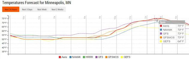
Lukewarm Again. Today will be perfectly normal, for the 8th day of September. Models show highs in the low to mid 50s, nearly 20F warmer than average. Whatever “average” is. Graphic: Aeris Enterprise.
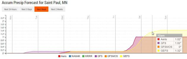
Soggy, Deflated Friday Footballs. A shower may sprout late Tuesday, but there’s little question Friday will be the wettest day of the week as tropical moisture fuels as slow-moving cool front. Some models are printing out over 1″ of rain. Behind the front skies clear on Saturday as temperatures drop (slightly).

A Fairly Benign Pattern. I’m not complaining – I’m sure there will be payback down the road, but looking out 10 days a mostly-zonal jet stream pattern prevents any wild swings in temperature. Tropical moisture may still douse Texas the Gulf Coast, but the potential for tropical development in the Gulf of Mexico has diminished, according to NOAA NHC.
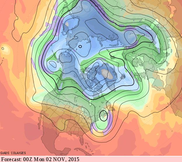
Mild Bias Continues into Early November. New England looks stormy and cool by Halloween, with periods of heavy rain and mountain snows for the Pacific Northwest, but the rest of the USA looks fairly quiet – and milder than average. 500 mb winds, courtesy of NOAA’s GFS model, valid Sunday evening, November 1.
Hundreds of People Rescued After Mudslides Bury Parts of California Highways. Freakish, slow-moving thunderstorms Thursday dumped torrential rains in a very short period of time, closing I-5. Here’s an excerpt from CBC News: “Rescuers threw ladders and tarps across mud up to almost two metres deep to help hundreds of trapped people from cars that got caught in a roiling river of mud along a major southern California trucking route, a California Highway Patrol official said Friday in what he and other witnesses described as a chaotic scene. Amazingly, officials said, no deaths or injuries were reported. The people rescued from State Route 58, about 50 kilometres east of Bakersfield, were stranded in a powerful storm on Thursday evening…”
Photo credit above: “In this photo provided by Caltrans, vehicles are stopped in mud on California’s Interstate-5 after flooding Thursday.” (Caltrans/Associated Press).
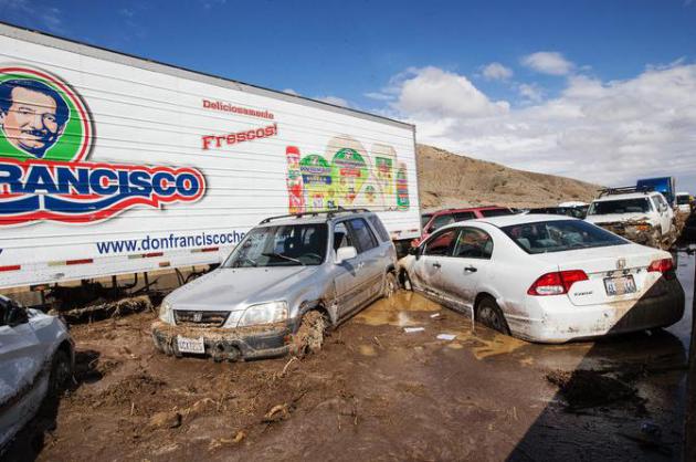
A “Wall of Mud” in California, and Warnings to Heed El Nino. Some of the first tangible symptoms of El Nino? Here’s a clip from The New York Times: ” With strong El Niño conditions now established in the Pacific Ocean, Southern California has been getting a taste of what might be in store this winter: lots of desperately needed rain, but also dangerous mudslides and flash flooding. After several hours of heavy rain, mud and debris cascaded down hillsides north of Los Angeles on Thursday, blocking two freeways, including Interstate 5, the critical artery linking this city with San Francisco, Sacramento and Seattle. Mud, sometimes up to windshields, swallowed hundreds of vehicles across the region. Traffic coming south toward Los Angeles all but stopped, stranding travelers far from home…”
Photo credit above: “About 115 cars and 75 tractor-trailers were stuck on State Route 58. “It’s a miracle no one was seriously hurt,” Ray Pruitt, a spokesman for the Kern County sheriff, said.“ Credit Monica Almeida/The New York Times

El Nino Impacts on Ocean Warming. El Nino warming is superimposed on a global warming trend of the world’s oceans. Here’s an excerpt from Climate Central: “This year is on track to be the hottest on record globally. The strong El Niño is likely playing a role as the average global temperature of an El Niño year is 0.4°F higher than a La Niña year. However, the strong El Niño is not solely responsible for the warming planet. Global temperatures have been trending upward since 1950, regardless of whether or not the Pacific Ocean was in an El Niño, La Niña, or neutral phase. In fact, La Niña years in the 21st Century are now warmer than El Niño years just 30 years ago. Similarly, the long term trend of global ocean water temperatures is on the increase, emphasizing that El Niño is only magnifying the ongoing warming trend…”
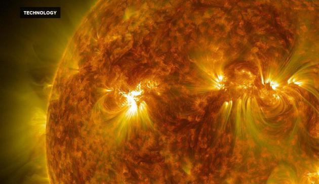
How Accurate Are Solar Flare Detection Technologies? Short answer: not very, and the really big solar storms, the X-level events, may not be detected in advance, according to a story at RedOrbit; here’s an excerpt: “A new study from the Tihany Magnetic Observatory in Hungary has explained why solar weather indicators wouldn’t have been able to predict the Carrington Event, a large solar storm that occurred in 1859, according to a press release from the Spanish Foundation for Science and Technology (FECYT). Predicting solar flares is important for keeping power supplies and communication networks safe, as the flairs can disrupt or even damage electronics. However, the methods currently used to predict solar storms aren’t perfect...” (Image credit: NASA).


TUESDAY: Patchy clouds, PM shower? Winds: E 8-13. High: 65
WEDNESDAY: Slow clearing, a bit cooler. Wake-up: 52. High: 61
THURSDAY: Sunny and pleasant. Wake-up: 43. High: 63
FRIDAY: Wettest day of the week. Showery rains likely. Winds: SE 10-20. Wake-up: 49. High: 59
SATURDAY: Getting sunnier, very nice. Winds: NW 8-13. Wake-up: 47. High: 59
Climate Stories…
It’s Far Worse Than It Sounds: Climate Change Is Making Our Winters Shorter. Not every winter, but most winters are trending shorter (as defined by extreme low temperatures). It may be making winters snowier for coastal cities, especially New England and Mid Atlantic. A warmer ocean and atmosphere means more water vapor floating overhead, more fuel for not only extreme summer rains but heavy winter snows. Here’s an excerpt from Salon: “If winter comes… spring’s going to be closer-than-usual behind. New research shows that as a result of rising temperatures caused by global climate change, the first leaves and buds of spring will begin arriving at least three weeks ahead of time in the United States. Researchers at the University of Wisconsin-Madison examined the variations and trends in the onset of spring across the Northern Hemisphere’s temperate regions and calculated that the onset of spring plant growth will shift by a median of three weeks earlier over the next century. Their findings were published in the journal Environmental Research Letters yesterday…”
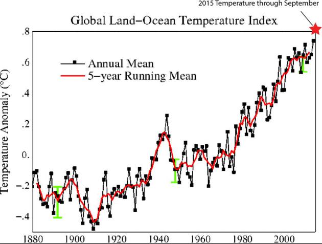
No Warming in 18 Years? That’s one of the popular memes from professional skeptics, but when you factor oceans (92% of the sun’s energy goes into the oceans) the Global Land-Ocean Temperature Index is ever upward and onward, probably setting a new temperature anomaly record in 2015. Graph courtesy of Dr. John Abraham at The University of St. Thomas.
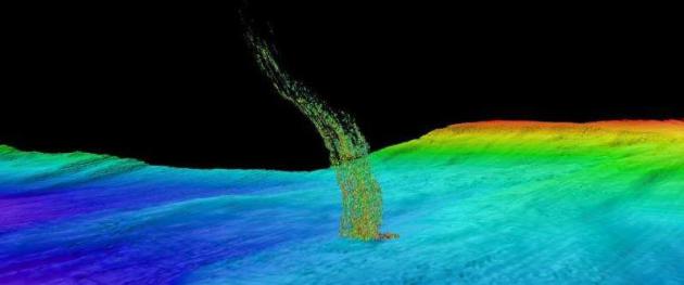
Ocean Methane Release Points to Global Warming. What other tipping points are lurking out there? Expect more holy-crap moments. Here’s an excerpt from Immortal.org: “Climate change isn’t just affecting the temperatures above ground. According to a recent research project by the University of Washington, the Pacific Ocean’s deep-water temperatures are rising enough to thaw out ancient deposits of frozen methan. A recent Phys.org report noted that the scientists discovered the methane thaw when they observed plumes of methane bubbles rising up from the ocean flood off the coast of Washington and Oregon...”
Image credit above: “Sonar image of bubbles rising from the seafloor off the Washington coast. The base of the column is 1/3 of a mile (515 meters) deep and the top of the plume is at 1/10th of a mile (180 meters) depth.” Credit: Brendan Philip/University of Washington.
Read more at: http://phys.org/news/2015-10-plumes-washington-oregon-warmer-ocean.html#jCp
Read more at: http://phys.org/news/2015-10-plumes-washington-oregon-warmer-ocean.html#jCp
Read more at: http://phys.org/news/2015-10-plumes-washington-oregon-warmer-ocean.html#jCp
Read more at: http://www.immortal.org/18896/ocean-methane-release-points-global-warming/

Canada’s Frozen North Feels Financial Burn of Global Warming. Here’s an excerpt from Reuters: “Climate change is taking a heavy economic toll on Canada’s far north, with buildings collapsing as melting permafrost destroys foundations, rivers running low and wildfires all a drain on the region’s limited finances, senior government officials said. A sprawling area spanning the Arctic Circle with a population of less than 50,000, Canada’s Northwest Territories has spent more than $140 million in the last two years responding to problems linked to global warming, the territory’s finance minister said. “Our budgets are getting squeezed dramatically from climate change,” Finance and Environment Minister J. Michael Miltenberger told the Thomson Reuters Foundation…”
