89 F. high in the Twin Cities Sunday.
79 F. average high on August 24.
90 F. high on August 24, 2013.
.14″ rain fell at MSP International Airport as of 7 PM yesterday.

Big 3-0
“I love being married. It’s so great to find that one special person you want to annoy for the rest of your life” said comedian Rita Rudner.
What’s it like being married to a weatherman? “Mostly sunny with occasional storms” my wife sighed. “I prefer sunshine”. Laurie and I are heading to Dublin, Ireland to celebrate our 30th anniversary, watch some college football and enjoy occasional showers of Guinness. Volcano-permitting, that is.
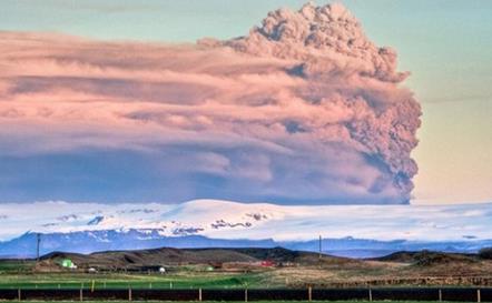
I’m tracking the grumbling Bardarbunga volcano in Iceland, which may blow its top at any moment. A major Icelandic eruption in 2010 grounded millions of air travelers over 8 days, costing airlines nearly $2 billion. Dubuque is looking better & better. Cheaper too.
Yesterday’s thundery frontal zone is pushing east; Canadian exhaust dropping humidity levels back down to tolerable levels. Dew points tumble into the 40s by midweek, meaning HALF as much water floating overhead. It now looks like showers stay south of Minnesota until Thursday & Friday, with a holiday weekend clearing trend and highs near 80F. A few storms may pop (right on schedule) on Labor Day.
What can possibly go wrong?
I can almost promise a lack of flurries.
Or volcanoes.
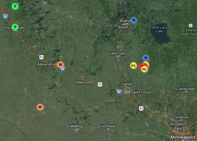
Sunday Severe Weather Reports. Funnel clouds were spotted near Rice, with tornado touchdowns at Granite Ledge (Benton County) and damage in the Gilman area. Elsewhere large hail was spotted just east of Brainerd, flash flooding near Fergus Falls and reports of storm-related wind damage east of Alexandria. A trained spotter reported 2.2″ diameter hail 7.5 miles south of Hillman, in Morrison County, around 6 PM. The Twin Cities National Weather Service has an interactive map. Additional storm reports are here.
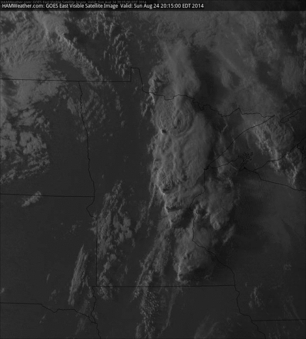
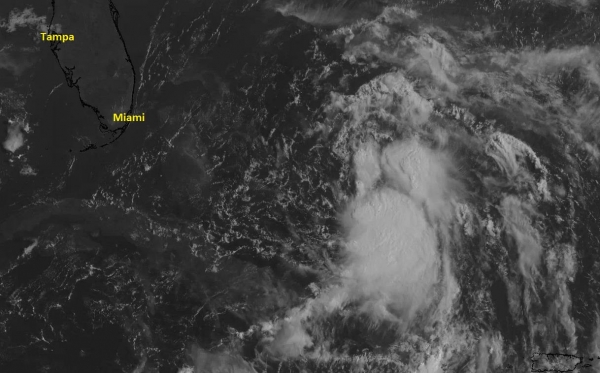
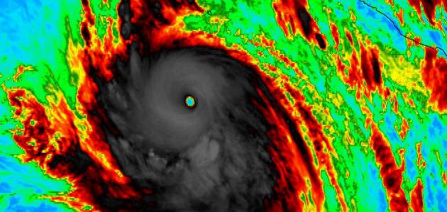
Late August Supercells. Sunday’s late afternoon visible cloud loop shows the squall line that sprouted over central Minnesota, the most severe cells from near Brainerd to just north of St. Cloud. By late August the atmosphere is usually more stable (cooling near the surface, still warm aloft), so tornadic storms are unusual, but certainly not unprecedented. Imagery: NOAA and HAMweather.
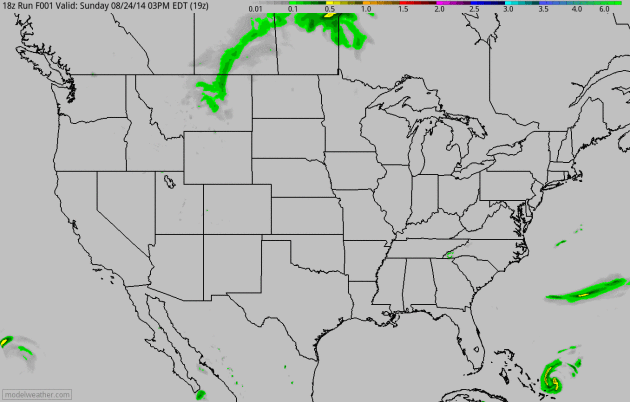
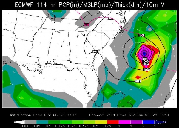
Cristobal Stalks the Bahamas – Heavy Storms Push into the Great Lakes. The 60-hour accumulated rainfall map shows some heavy 2-4″ amounts from near Wausau to near Madison and Chicago as slightly cooler air pushes east. This weak frontal zone stalls, sparking more heavy rain across Iowa by Tuesday and Wednesday. 4 KM NAM data: NOAA and HAMweather.
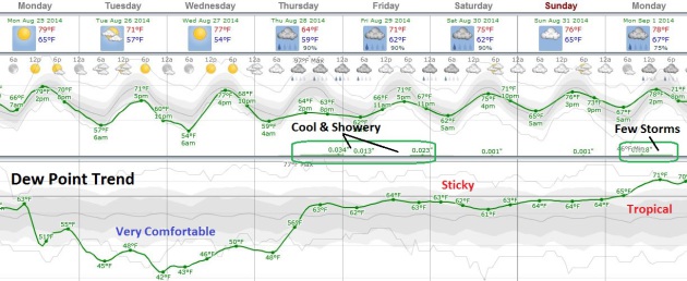
Trending Comfortable. Sick of dreadful dew points hovering near 70F? You’re in luck. Canadian air drops moisture levels significantly, less than half as much water in the air by this time Tuesday. Dry weather should prevail today into Wednesday, the next surge of warm air sparking a few showers and T-showers Thursday and Friday. Long-range guidance shows some weekend clearing, with the best chance of rain (and storms) on Labor Day. With any luck the forecast will change as new data comes in.

Alerts Broadcaster Update. Here’s an excerpt of a briefing that went out Sunday:
* Tropical Storm Cristobal intensifying – will impact Bahamas with tropical storm force conditions over the next 24 hours.
* All models show a track that keeps the core of Cristobal’s strongest winds and storm surge at sea this week.
* Dangerous rip tides and some minor coastal flooding can’t be ruled out across the Carolina coast Wednesday and Thursday of this week, especially close to high tide.
Better Organized. Satellite imagery shows a more symmetric storm circulation, less wind shear will favor additional strengthening in the coming days; Cristobal expected to become a Category 1 hurricane well east of the Carolinas late Wednesday night or Thursday morning.
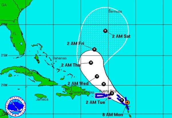
Projected Track. NOAA’s National Hurricane Center shows a track to the north/northwest into Wednesday, followed by a northeastward turn which should keep the brunt of Cristobal out at sea; but uncomfortably close for North Carolina’s Outer Banks.
Rapid Intensification by Thursday. Warm Atlantic ocean water will fuel further intensification, and the ECMWF (European) model shows a potential for a Category 1-2 hurricane the latter half of this week with additional strengthening as Cristobal veers out to sea. Map: WSI.
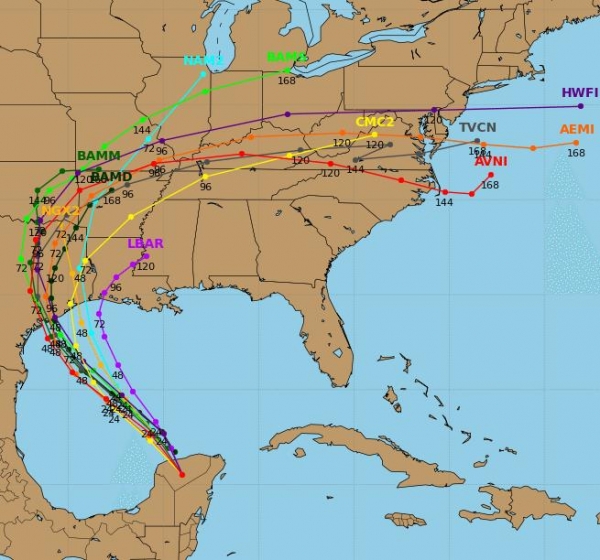
General Model Agreement. Although far from perfect, models are all displaying a version of the solution, keeping Cristobal’s core out to sea with a turn to the northeast after 96-120 hours. No models (we trust) are bringing Cristobal toward a U.S. landfall at this time.
Summary: We’ve been watching the evolution of Cristobal, and expect minor to moderate impact over the Bahamas today, especially Great Abaco and Grand Bahama (including the city of Freeport). Flash flooding is expected with winds in the 35-50 mph range in squalls over the next 24 to 36 hours. All computer solutions keep Cristobal’s core of strongest winds, heaviest rains and highest storm surge east of the U.S. mainland, but minor lowland flooding is still possible along the Carolina coast by midweek – especially at local high tide. We’ll keep an eye on Cristobal and keep you posted should there be a material change to our predictions.
Paul Douglas – Senior Meteorologist – Alerts Broadcaster

Farmer’s Almanac Predicts “Super Cold” Winter, More Snow in Eastern U.S. I’m always shocked when Minnesota doesn’t experience a super-cold winter. Take any long range forecast with a massive grain of salt, but I am going on record stating the odds of something similar to last winter’s polar vortex are slim to nil. Cold with significant snow? Absolutely, but not the extreme levels of cold we endured last winter. Here’s an excerpt from Huffington Post: “The Old Farmer’s Almanac, the familiar, 223-year-old chronicler of climate, folksy advice and fun facts, is predicting a colder winter and warmer summer for much of the nation. Published Wednesday, the New Hampshire-based almanac predicts a “super-cold” winter in the eastern two-thirds of the country. The west will remain a little bit warmer than normal…”
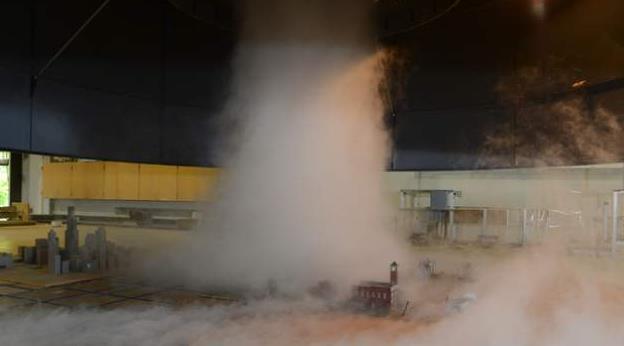
Researchers Dig Deeper Into Tornado Winds, Building Damage. Here’s a clip from an interesting line of research described at The Ames Tribune: “…By measuring on the Enhanced Fujita (EF) Scale, which evaluates storm damage to measure the strength of tornadoes, around 90 percent of all tornadoes are an EF3 or less. Sarkar, who has been at ISU for 14 years, believes the strength of tornado winds is debateable. The scale of a tornado is only determined after the damage has been examined. There are also many other factors that can throw off an examination such as the building’s age, the material strength, construction quality and prior weaknesses caused by debris...”
Sarkar, who has been at ISU for 14 years, believes the strength of tornado winds is debateable. The scale of a tornado is only determined after the damage has been examined. There are also many other factors that can throw off an examination such as the a building’s age, the material strength, construction quality and prior weaknesses caused by debris.
– See more at: http://amestrib.com/news/researchers-dig-deeper-tornado-winds-building-damage#sthash.uQtrvLaL.dpuf
Photo credit above: “A laboratory-simulated tornado at the ISU Tornado Simulator translates over a scaled model of buildings. Model tornadoes like this one will be used to further study near-ground wind and their loading effects on civil structures such as buildings to reduce tornado hazard.” Photo: Bob Elbert/Iowa State University.
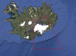
Iceland Volcano Experts: No Eruption Yet. As they say, the “situation is fluid”. As in magma-fluid, and at some point that lava may reach the surface, like an enormous, angry pimple. The impact to trans-Atlantic flights is still unclear, but if history is a guide there could be serious implications in the coming weeks. Here’s an excerpt of an update from a good source of local information, RUV: “…The most likely scenario is that an eruption has not begun. This morning we saw a large increase in seismic activity and tremors, so it was perfectly rational to assume that an eruption had begun. A subglacial eruption melts the ice and causes floods. We surveyed the glacier for three hours today. I can of course not assert that nothing has happened, but it is clear that there are no signs of abnormal melting or other signs that normally appear during a subglacial eruption…”
* The Icelandic Civil Protection Agency has continuous updates in a live-blogging format here.

What It Feels Like To Be The Last Generation To Remember Life Before The Internet. Are you old enough to remember a time before Netscape Mozilla’s crude web browser and AOL “You’ve Got Mail”? Me too. I miss those simpler days when people used rotary phones and there was a place where you could gather to talk to your friends. It was called a “bar”. That’s why this story at Quartz caught my eye; here’s a clip: “Technology has a lot to answer for: killing old businesses, destroying the middle class, Buzzfeed. Technology in the form of the internet is especially villainous, having been accused of everything from making us dumber (paywall) to aiding dictatorships. But Michael Harris, riffing on the observations of Melvin Kranzberg, argues that “technology is neither good nor evil. The most we can say about it is this: It has come...”
Photo credit above: “Michael Harris, the author of “The End of Absence.” Hudson Hayden.

9 Things Good Listeners Do Differently. Part of the secret of business is knowing when to say no, and really listening to what clients and prospects are telling you. Less selling, more listening. Here’s an excerpt from a story at Huffington Post that caught my eye (and ear): “…Part of effective listening is the effort to empathize with the person you’re speaking with. Whether or not you’re able to fully relate, your compassion won’t go unnoticed. “Spend a moment putting yourself in their position, what’s going through their head and what it must be like for them,” Sacco says. “Understanding what their experience is even before you talk to them [can help you connect with them]. And it sounds bad, but even if you blow it, you’re still better off because the other person will see the attempt…”

Isolated Downpour/Hailstorm. I took up the ALS Ice Bucket Challenge Sunday, before the real hail storms arrived. It wasn’t pretty. Belinda Jensen at KARE, and Kristin Clark at Media Logic Group – it’s your turn!


TODAY: Partly sunny, less humid. Dew point: 58. Winds: W 10. High: 82
MONDAY NIGHT: Clearing and comfortable. Low: 59
TUESDAY: Intervals of sun, no drama. Dew point: 48. High: 73
WEDNESDAY: Blue sky, still pleasant. Wake-up: 55. High: 76
THURSDAY: Cloudy. Showers develop, coolest day. Wake-up: 59. High: 69
FRIDAY: Leftover shower or T-shower. Wake-up: 60. High: 72
SATURDAY: Partly sunny, lukewarm. Dew point: 61. Wake-up: 61. High: 76
SUNDAY: Peeks of sun, probably dry. Wake-up: 62. High: near 80
Climate Stories…
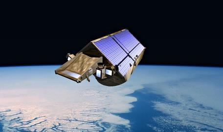
“Incredible” Rate of Polar Ice Loss Alarms Scientists. Here’s an excerpt from The Guardian: “The planet’s two largest ice sheets – in Greenland and Antarctica – are now being depleted at an astonishing rate of 120 cubic miles each year. That is the discovery made by scientists using data from CryoSat-2, the European probe that has been measuring the thickness of Earth’s ice sheets and glaciers since it was launched by the European Space Agency in 2010. Even more alarming, the rate of loss of ice from the two regions has more than doubled since 2009, revealing the dramatic impact that climate change is beginning to have on our world…”
Photo credit above: “An artist’s impression of CryoSat-2, the European satellite which has revealed dramatic ice loss.” Photograph: ESA.
What Iceland’s Volcanoes Can Teach Us About Climate. Here’s a brief excerpt from an interesting story at Climate Central: “…Glacial volcano research also helps improve climate change modeling by preserving a record of ice sheets that melted long ago. Think of the ice as a sort of cast for a lava sculpture. “When a volcano erupts, it copies the ice in a sense,” says Smellie. “The ice tells the volcano how to erupt, when it can erupt, and what kind of lava forms…”
Photo credit above: “Local flooding could be particularly severe in the case of an eruption, which would melt significant chunks of the Vatnajokull glacier.” Credit: Gunnlaugur bor Briem/flickr.

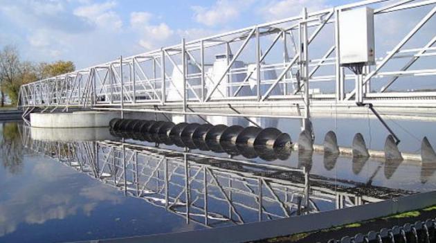
Climate Change and Drought Are Forcing Us to Upgrade our Water Systems. Public Radio International has an interesting article and interview, talking about the need to upgrade from Water 1.0 to Water 4.0. Here’s a clip: “…Throughout history, he says, each time we have encountered seemingly intractable problems with water supply, we have found solutions. We create and adapt to new technologies and we “become comfortable with water that’s treated, or sewage that’s treated, or water that’s imported.” We’re already familiar with one of the tenets of Water 4.0 — conservation. “Quietly, over the last 10 or 20 years, we’ve seen indoor plumbing change as people are, for example, switching out their top-loading washing machines for front-loading washing machines,” Sedlak points out. “We’ve saved a lot of water that way. [But] we can do better and we will do better…”
Photo credit above: “Wastewater treatment plant.” Hasan Zulic; Creative Commons.

The Climate Swerve. The New York Times had an Op-Ed comparing the specter of climate change and impacts on future generations to nuclear proliferation and the prospect of nuclear war in the 1980s. Here’s a clip: “…The experiential part has to do with a drumbeat of climate-related disasters around the world, all actively reported by the news media: hurricanes and tornadoes, droughts and wildfires, extreme heat waves and equally extreme cold, rising sea levels and floods. Even when people have doubts about the causal relationship of global warming to these episodes, they cannot help being psychologically affected. Of great importance is the growing recognition that the danger encompasses the entire earth and its inhabitants. We are all vulnerable…”
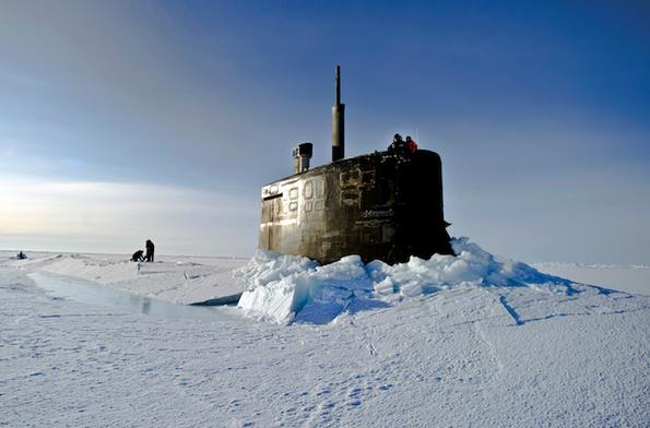
Climate Change and Implications for National Security. Here’s an excerpt of a story at International Policy Digest: “…Over the 250 years carbon fuels have enabled tremendous technological advances including a population growth from about 800 million then to 7.5 billion today and the consequent demand to extract even more carbon. This has occurred during a handful of generations, which is hardly noticeable on our imaginary one-year calendar. The release of this carbon – however – is changing our climate at such a rapid rate that it threatens our survival and presence on earth. It defies imagination that so much damage has been done in such a relatively short time. The implications of climate change are the single most significant threat to life on earth and, put simply, we are not doing enough to rectify the damage…”
Photo credit above: Department of Defense photo. “If you wait until you have 100 percent certainty, something bad is going to happen…” – General Gordon R. Sullivan, Retired, former U.S. Army Chief of Staff.
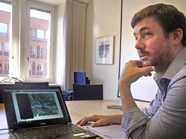
Kansas’ Climate Change Debate Settled in Europe. While Americans debate the science much of Europe is moving forward with plans to scale back the use of fossil fuels. What’s missing here? Environmentally-minded Americans who care about this issue have yet to band together and exert political pressure. That will change in the years ahead (with our kids and grandkids out in front). Here’s an excerpt from CJOnline.com: “…One of the key differences, King said, is the influence of Green parties within European nations. To get action on climate change, he said, environmentally-minded Americans must increase their influence in the political sphere. In Germany, the Greens hold about 10 percent of the seats in a 631-member parliament made up of five parties. Oliver Krischer, vice chairman of the German Green Party’s parliamentary group, said he hasn’t heard members of other parties say they believe human-caused climate change is a myth. “There might be some colleagues in the Bundestag that think so,” Krischer said. “You cannot look in their heads. But there is at least nobody that says climate change is an invention of some scientists...”
Photo credit above: Andy Marso, The Capital-Journal. “Jon Möller, a researcher with the Stockholm city government’s climate and energy division, shows a map that includes the city’s Royal Seaport, which citizens intend to make free of fossil fuels by 2030.”

Portraits of Scared Scientists Seek to Drive Home the Critical State of Climate Change. The most frightening thing about climate change is that we continue to ignore it. Here’s a clip from a story at PetaPixel: “Photographer Nick Bowers, Art Director Celine Faledam and Copy Writer Rachel Guest have teamed up to bring attention to the issue of climate change in a completely novel and frankly terrifying way with their portrait/interview project Scared Scientists. The title, in a way, says it all. Rather than bombarding you with obscure facts and figures or showing you photographs of receding glaciers, they focus on the scientists themselves...”
Dangerous Climate Change: Myths and Reality. Predicting the future is tenuous. Are we underestimating or overestimating the impacts of AGW? One thing is certain: the last time there was this much carbon, methane and other greenhouse gases floating overhead humans weren’t on the planet. Here’s an excerpt of an article at Climate Code Red focused on the myth (?) that climate change is “not yet dangerous”: “…From this perspective, tipping points have already been passed, at less than 1°C of warming, for:
- The loss of the Amundsen Sea West Antarctic glaciers, and 1–4 metres of sea level rise (Rignot, Mouginot et al., 2014; Joughin, Smith et al., 2014). Dr Malte Meinshausen, advisor to the German government and one of the architects of the IPCC’s Representative Concentration Pathways, calls the evidence published this year of “unstoppable” (Rignot, 2014) deglaciation in West Antarctica “a game changer”, and a “tipping point that none of us thought would pass so quickly”, noting now we are “committed already to a change in coastlines that is unprecedented for us humans” (Breakthrough, 2014).
- The loss of Arctic sea-ice in summer (Duarte, Lenton et al., 2012; Maslowski, Kinney et al., 2012), which will hasten regional warming, the mobilization of frozen carbon stores, and the deglaciation of Greenland...”
Photo credit above: Jenna Dorsey.
