Comfortable Today – Hot And Sticky By Tuesday
By DJ Kayser, filling in for Douglas
Some like it… muggy?
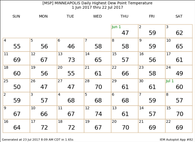
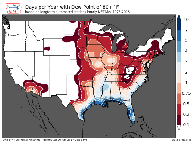
I know I personally don’t, but muggy weather and summer always go hand in hand. If you are a fan of muggy weather, you certainly enjoyed last week as all but one day saw the dew point at or above 65 at some point during the day. Since June 1st, 21 days have had a dew point at or above 65 in the Twin Cities, and a third of those days have had a 70+ degree dew point. That’s still better than parts of Iowa, which saw dew points in the 80s last Thursday!
Sunday gave us a break from the muggy weather, and that comfortable weather continues today, with highs around 80 and dew points hovering in the 50s. As we head toward the middle of the week, however, sticky weather returns with storms likely. Some of those storms could be strong, with the potential of heavy rain as well. Pleasant weather then returns in the form of Canadian high pressure late in the week.
I’m sure we won’t be done with the summer heat and humidity though – we still have August to get through, and the State Fair is only a month away!
TUESDAY: Muggy. Late day storms. High 91. Low 72. Chance of precipitation 60%. Wind S 5-15 mph.
WEDNESDAY: Storm chance lingers in southern MN. High 83. Low 65. Chance of precipitation 50%. Wind NW 5-15 mph.
THURSDAY: A very pleasant, sunny day. High 82. Low 65. Chance of precipitation 0%. Wind N 5-10 mph.
FRIDAY: Sunny. Nice end to the week. High 83. Low 66. Chance of precipitation 0%. Wind SE 5-10 mph.
SATURDAY: A touch muggier. Mainly sunny skies. High 85. Low 67. Chance of precipitation 20%. Wind SW 5-10 mph.
SUNDAY: Early morning storms. Turning sunny. High 81. Low 58. Chance of precipitation 30%. Wind NW 5-10 mph.
This Day in Weather History
July 24th
1987: A historic deluge ends in the Twin Cities. Two-day totals include over a foot of rain at Bloomington. Nearly 10 inches falls in downtown Minneapolis, and near 9 inches is recorded in St. Paul. At one time the water reaches a depth of 13.5 feet on I-494 near East Bush Lake Road. I-494 in Bloomington would be closed for nearly 5 days.
1891: Heavy frost hits Elkton in Mower County in southeast Minnesota. The frost kills all vegetable crops. The low in Elkton is 34, and the Twin Cities have a low of 49.
_______________________________________________
Average Temperatures & Precipitation for Minneapolis
July 24th
Average High: 83F (Record: 104F set in 1936)
Average Low: 64F (Record: 49F set in 1891)
Average Precipitation: 0.14″ (Record: 1.69″ set in 2012)
________________________________________________
Sunrise/Sunset Times for Minneapolis
July 24th
Sunrise: 5:50 AM
Sunset: 8:48 PM
*Length Of Day: 14 hours, 58 minutes and 24 seconds
*Daylight Lost Since Yesterday: ~2 minute and 5 seconds
*Next Sunrise At/After 6 PM: August 2nd (6:00 AM)
*Next Sunset At/Before 8:30 PM: August 8th (8:29 PM)
________________________________________________
Minnesota Weather Outlook
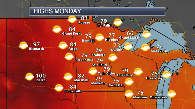
Another nice day is expected across the state Monday, with highs in the 70s in most spots. Areas along Lake Superior will likely stay in the 60s, with areas of western Minnesota reaching the low 80s. The hot weather will stay out in the Dakotas, where Pierre is likely to top 100.
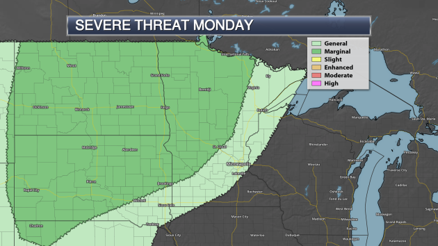
As we head toward the overnight hours, however, storms are expected to form across the Dakotas and eventually move into parts of western Minnesota. These stronger storms may be capable of damaging winds.
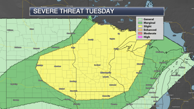
A severe risk will exist on Tuesday as well as the cold front moves through the upper Midwest. The greatest risk will be during the overnight hours across the region with damaging winds. However, hail and tornadoes will be possible, especially if any storms pop during the afternoon and evening.
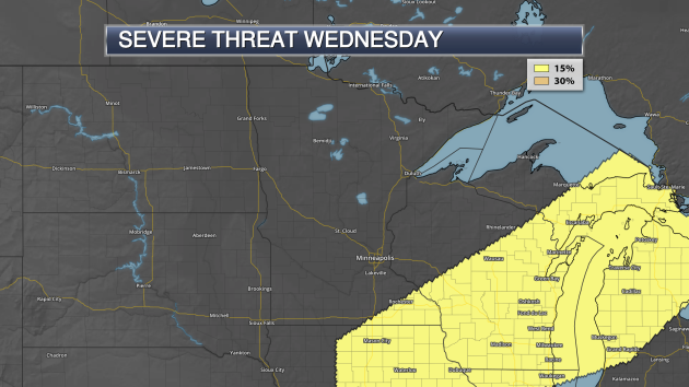
Isolated severe storms will continue to be possible across southeast Minnesota Wednesday as the cold front continues to move through.
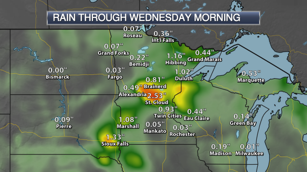
Heavy rain will be possible with these storms as well. The models are showing some of heaviest will be possible across southwest and central Minnesota, with the potential of over 2″ in St. Cloud.
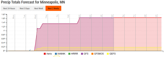
After the rain expected toward the middle of the week, the next rain chance will move in Saturday Night as a cold front sweeps through the state. After that, modes indicate drier weather through the first week of August.
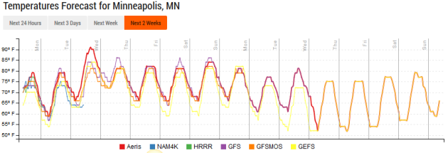
The warmest weather over the next couple weeks appears to be Tuesday, when temperatures will be pushing 90 in the Twin Cities. Otherwise, models are showing highs at or below average into the beginning of next month.
_______________________________________________
National Weather Outlook
Monday Forecast
Finally the heat is starting to break across portions of the central U.S. as we head into Monday (at least for a day) as temperatures will only be around 90 in St. Louis. Monsoonal storms will continue to be possible across parts of the Southwest, meanwhile a frontal system brings the chance of storms from the Northeast to the southern Plains.
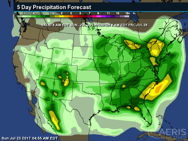
The heaviest rain through Friday will be in the eastern U.S., where some areas from New York to the Carolina coasts could pick up two inches or more of rain. Heavy rain will also be possible in parts of the Southwest thanks to monsoonal storms.
_______________________________________________

________________________________________________
Thanks for checking in and have a great Monday! Don’t forget to follow me on Twitter (@dkayserwx) and like me on Facebook (Meteorologist D.J. Kayser)!
– D.J. Kayser

