Dry Weather Continues Until Midweek
By D.J. Kayser, filling in for Paul Douglas
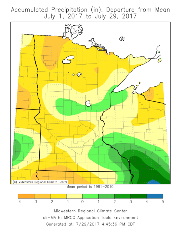
The sprinklers have been getting some use in my neighborhood this July, as it has been a fairly dry month across Minnesota with many areas reporting below average rainfall. The driest areas of the state have been in western Minnesota, where some spots are reporting 2-4” rainfall deficits. The good news is that soil moisture hasn’t taken a big hit so far, with less than 20% of topsoil and subsoil moisture supplies rated either short or very short across the state as of last week.
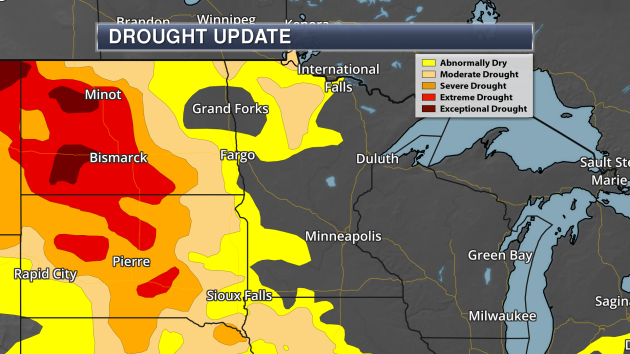
Conditions are worse as you head west, however. The USDA reports that at least two-thirds of the topsoil moisture conditions in North Dakota, South Dakota and Montana are rated short or very short. The U.S. Drought Monitor now has 7.6% of North Dakota and 11.9% of Montana in exceptional drought – the highest category.
While an isolated storm is possible today – mainly across northern Minnesota – the next chance of rain won’t work in until the middle of the week in the Twin Cities. Behind that midweek rain, highs will settle into the 70s.
MONDAY: Sunny skies. Feeling muggy. High 84. Low 67. Chance of precipitation 0%. Wind SW 3-8 mph.
TUESDAY: Partly sunny. Afternoon storms. High 85. Low 65. Chance of precipitation 40%. Wind SW 5-10 mph.
WEDNESDAY: Lingering storms. A touch cooler. High 80. Low 60. Chance of precipitation 20%. Wind N 5-10 mph.
THURSDAY: Isolated storms. Otherwise sunny. High 76. Low 60. Chance of precipitation 20%. Wind NE 3-8 mph.
FRIDAY: A few pop-up afternoon storms. Otherwise sunny. High 77. Low 59. Chance of precipitation 20%. Wind E 3-8 mph.
SATURDAY: Sunny start. Some PM clouds. High 78. Low 60. Chance of precipitation 10%. Wind E 3-8 mph.
This Day in Weather History
July 30th
1971: A cool spell across Minnesota brings frost to northern Minnesota. Freezing temperatures are reported as far south as Pipestone.
_______________________________________________
Average Temperatures & Precipitation for Minneapolis
July 30th
Average High: 83F (Record: 100F set in 1933)
Average Low: 64F (Record: 50F set in 1971)
Average Precipitation: 0.14″ (Record: 1.65″ set in 1872)
________________________________________________
Sunrise/Sunset Times for Minneapolis
July 30th
Sunrise: 5:56 AM
Sunset: 8:41 PM
*Length Of Day: 14 hours, 45 minutes and 2 seconds
*Daylight Lost Since Yesterday: ~2 minute and 19 seconds
*Next Sunrise At/After 6 PM: August 2nd (6:00 AM)
*Next Sunset At/Before 8:30 PM: August 8th (8:29 PM)
_______________________________________________
Minnesota Weather Outlook
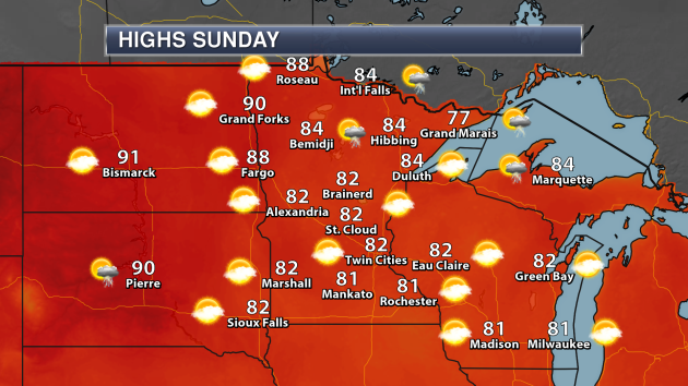
Another fantastic day is expected across the state Sunday, with only an isolated storm or two possible – mainly across northern Minnesota. Highs will be in the 80s in most spots, however the warmest weather will be in northwest Minnesota where highs could climb into the upper 80s.
Highs across northern Minnesota on Sunday will be above average for this time of year, and in some spots (especially across northwest Minnesota) they’ll be a good 5-10 degrees above average. Across southern Minnesota, the highs will be right around, if not slightly below, average for late July.
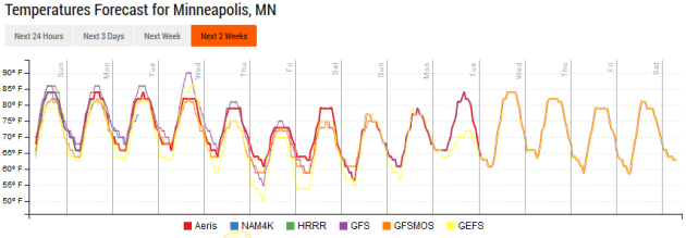
Highs will continue to be around average the next few days in the Twin Cities, with the warmest day likely to be Tuesday which is when some models hint that we could approach 90. After that, a cool front moves through, helping bring temperatures back into the 70s to end the week. Highs look to climb back into the 80s as we head into next week.
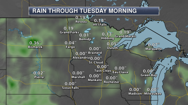
Precipitation chances look light across most of the state through Tuesday morning. We do have that isolated storm potential (mainly across northern Minnesota) Sunday, then another storm chance across that region Monday. A few of those storms Monday could be strong – more on that in a moment.
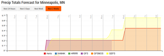
The next best chance of rain in the Twin Cities will be around the middle of the week – Tuesday into Wednesday – with maybe a quarter inch of rain possible. A few more isolated storm chances exist Thursday and Friday, however after that, rain chances look slim until we get to next week.
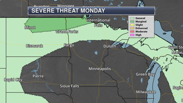
On Monday, a few stronger storms will be possible across northern Minnesota as a wave moves through the region. A Marginal Risk of severe weather is in place for this potential. The threats would be large hail and damaging winds.
_______________________________________________
National Weather Outlook
Sunday Forecast
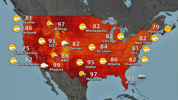
Sunday will be a sunnier day for areas of the Northeast, as highs climb back into the 80s for New York City and D.C. Rain will be possible across parts of the Southeast and the far Southern Plains. Heavy rain is possible across parts of the Southwest, where we will be tracking monsoonal storms as well as a back door cold front near the Front Range.
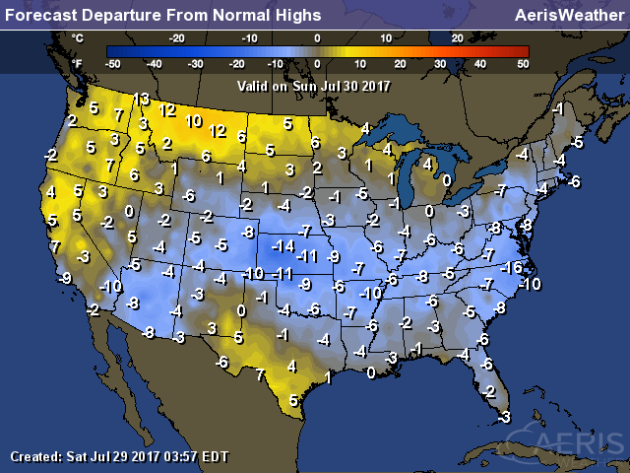
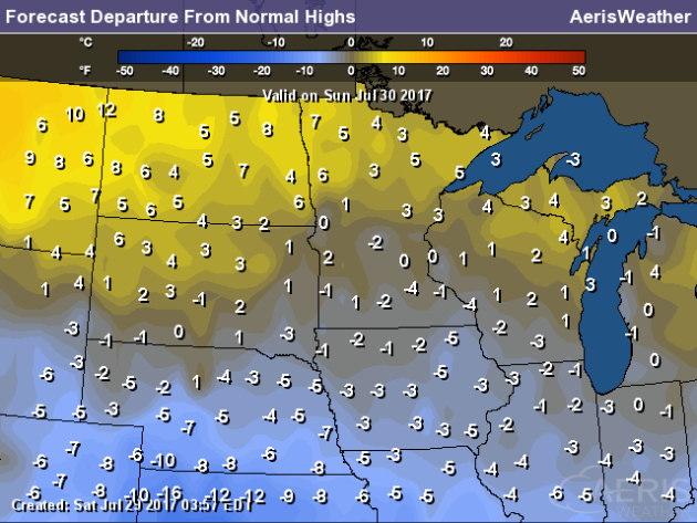
Cool weather will be the story across the majority of the U.S. on Sunday. The only areas anticipating above average temperatures will be in parts of southern Texas, and across the west coast into parts of the Northern Plains. The coolest weather compared to average for this time of year is expected in the central Plains, where highs could be 10-15 degrees below average.
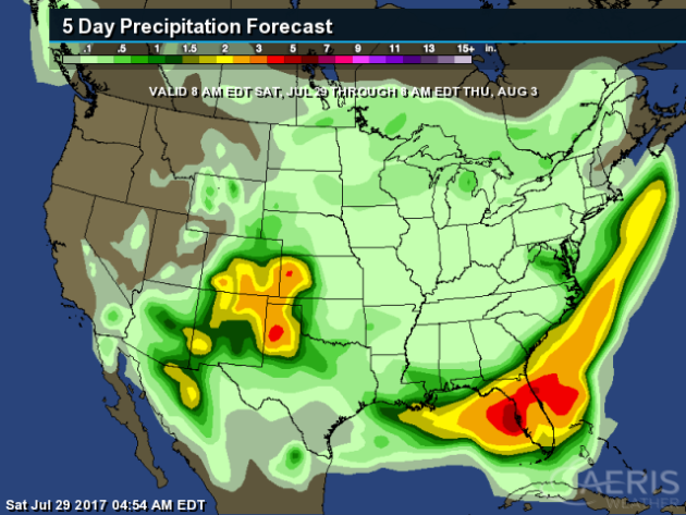
Through Thursday morning, the heaviest rain is expected across portions of Kansas, Colorado, Oklahoma, New Mexico and Texas, as well as across Florida, where over 4″ of rain could be possible in spots.
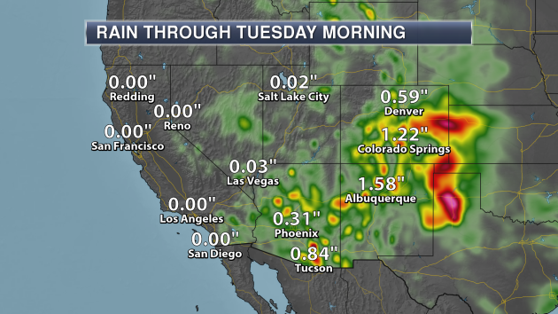
Monsoonal storms continue across the Phoenix and Tucson area over the next few days, but a back door cold front will help to bring heavy rain to parts of the Front Range and into western Kansas, the panhandle of Oklahoma and northern Texas through early in the week.
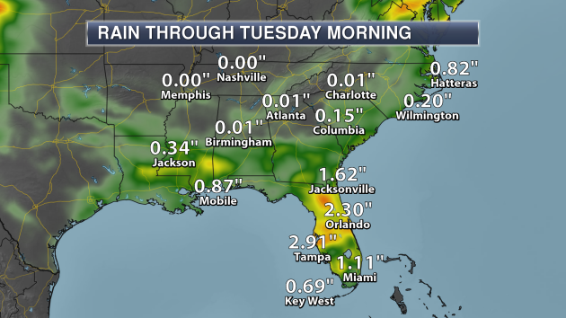
Meanwhile, copious amounts of moisture will be available for some heavy rain across the Florida peninsula through early in the week. Areas like Tampa and Orlando could receive over two inches of rain through Tuesday morning.
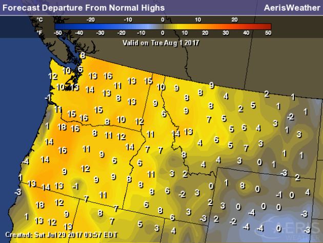
In the Northwest, it will be a hot start to August on Tuesday, with highs a good 10-20 degrees above average for this time of year in spots.
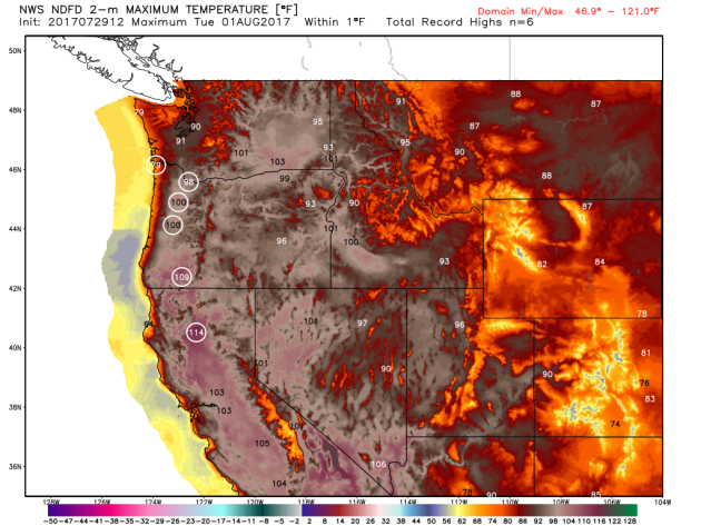
That means record highs will be possible as we head into Tuesday for areas like Portland, Medford and Redding. Portland could even approach 100, something they’ve only done once so far this year (back on June 25th when the high reached 101). Each circle represents a city that could see a record high on Tuesday.
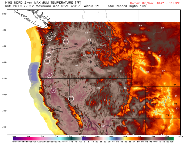
Records will continue into Wednesday across this region as well, even reaching as far north as Seattle.
_______________________________________________
11th Lightning Death Of 2017
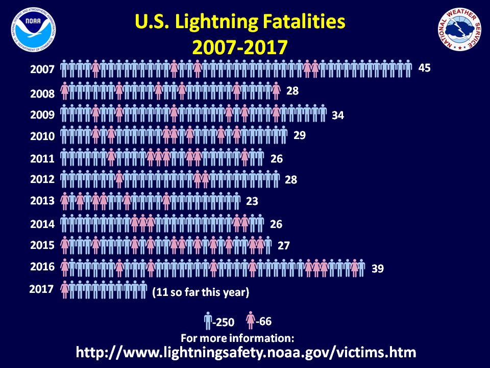
Unfortunately, the 11th lightning death of 2017 in the U.S. occurred Friday near Satellite Beach, FL. More from Florida Today: “Lightning struck two men, killing one, just north of Satellite Beach on Friday afternoon, according to the Brevard County Sheriff’s Office and Brevard County Fire Rescue. Brevard County Lifeguard Captain Ashley Nolan was the first to respond to help the men. The men were hit at SPRA Park in the 400 block of State Road A1A at the end of Berkeley Street.”
Must Have Weather Gear

Popular Science recently had an issue about extreme weather, and some gear that you should have with that will withstand the elements. More: “No matter the theme of the issue, every Popular Science highlights some of the best gear available—be that shiny embodiments of ingenuity or familiar products that, even decades later, still pass every test. For the gearheads in our family, we decided to showcase—in one place, all handy and organized—every product from our latest issue, which is all about extreme weather.” (Image: Sam Kaplan)
Fish More Polluted From Climate Change?
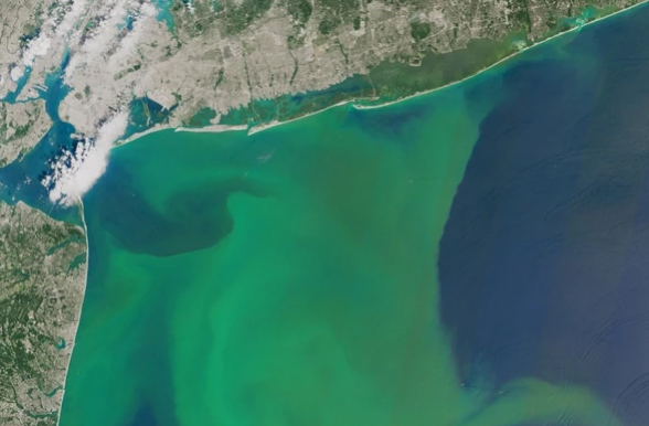
As heavier rain events become more common with a warming climate, we could see more fish being polluted due to increased nitrogen making it into our waterways. More from Scientific American: “What happens down on the farm could soon pose bigger problems downriver. Water undergoes deadly changes when enough fertilizers seep into rivers, lakes and streams. Algae growth explodes, oxygen levels drop and fish either leave the waterway or suffocate. Since the 1970s, large swaths of the Gulf of Mexico have transformed into so-called dead zones — covering an average area about the size of Connecticut — as agricultural runoff filters from the Mississippi River. The Chesapeake Bay and other fisheries have struggled with the problem, too.” (Image: Phytoplankton blooms off the Atlantic coast in August 2015. Credit: Joshua Stevens/NASA Earth Observatory)
The Biggest Wind Farm In The U.S. Will Be In Oklahoma

Who would of thought Oklahoma would have the biggest wind farm in the United States? GE is currently building it with Invenergy, and it is expected to be operational in 2020. More from Reuters: “Power development company Invenergy LLC and General Electric Co on Wednesday announced plans to build the largest wind farm in the United States in Oklahoma, part of a $4.5 billion project to provide electricity to 1.1 million utility customers in the region. The 2-gigawatt Wind Catcher wind farm is under construction in the Oklahoma panhandle and will come online in 2020. The facility will be linked to a 350-mile dedicated power line that will send the wind farm’s electricity to Tulsa.”
North Carolina Sees A Giant Increase In Solar Power

Numerous states are quickly jumping on the solar power bandwagon, with North Carolina being one of them. They saw the third largest increase in producing solar power since 2007. California and Arizona are the only states above North Carolina on the list. More from The News & Observer: “The Environment North Carolina Research and Policy Center noted advancements in the use of energy storage and electric vehicles in the state, which it also ranked 13th for energy efficiency. North Carolina has increased solar energy production from one gigawatt hour in 2007 to 4,016 in 2016, per the report.”
Record Breaking Temperatures In Miami
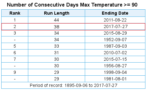
Records are being shattered this year in Miami, including approaching their most consecutive 90 degree days on record and even their hottest month on record. More from the Capital Weather Gang: “Miami is known for its steamy weather, but this year and this month, the city has shattered an astonishing number of records for hot weather. It’s having its hottest month ever recorded, and, so far, 2017 is its warmest year.”
Less Drinking Water In The Future?
Algal blooms could become more frequent in the future due to climate change… and that could actually lead to less drinkable water. More from WIRED: “LAST SUMMER, SOUTHERN Florida nearly ran out of water. It wasn’t drought—actually, the opposite. The state got way too much rain, which flushed nutrients from over-fertilized farms into its canals and reservoirs. All the extra food led to a massive algal bloom, a skim of blue-green slime that smells like rotten eggs and poisons humans. Governor Rick Scott declared a state of emergency in four counties.”
________________________________________________
Thanks for checking in and have a great Sunday! Don’t forget to follow me on Twitter (@dkayserwx) and like me on Facebook (Meteorologist D.J. Kayser)!
– D.J. Kayser

