1942: 1.8 inches of snow falls in St. Cloud.
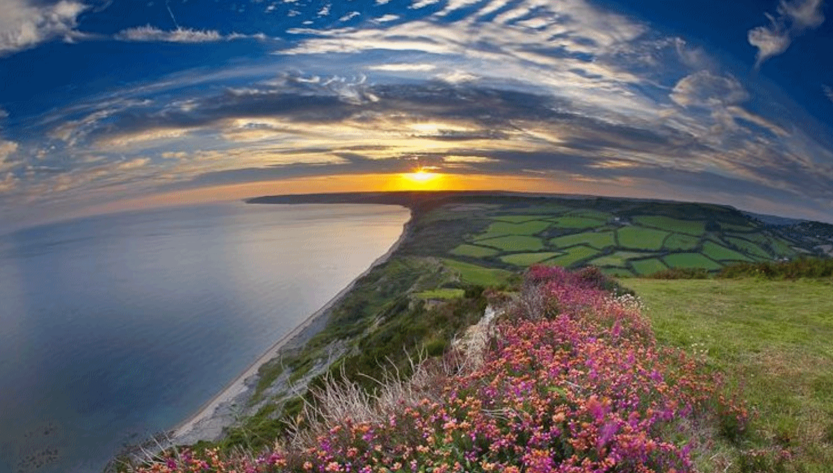
It Finally Feels Like September Out There
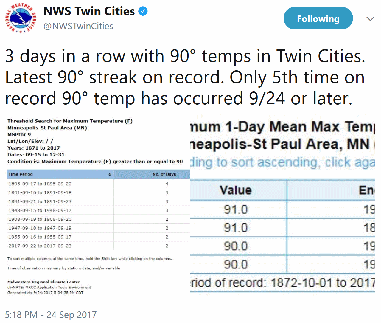
Well, I guess we made up for a cooler than average August, didn’t we. September is running nearly 6F warmer than average, after a recent run of obnoxiously hot and sweaty days. It wasn’t just your imagination: a streak of 90s in late September IS odd.
Kenny Blumenfeld, Senior Climatologist at the Minnesota Climatology Office, e-mailed “The most impressive one to me is that this was the latest in the year that the Twin Cities has had three consecutive days with highs of at least 90F *and* lows of at least 70F. In fact, the next-latest-in-the-year run concluded on September 12, 1931. So we broke this record by 12 days!”
No flurries or frost in sight (yet) but a cool correction is on tap this week with a string of 60s; much closer to average. Showers taper this morning, with generally dry weather this afternoon into Saturday.
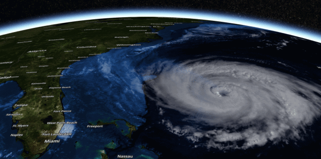
Meanwhile Maria buffets the Outer Banks of North Carolina with tropical storm force winds and coastal flooding today, a blunt reminder that hurricane season doesn’t wind down until November, when ocean water cools.
No weather complaints here anytime soon.
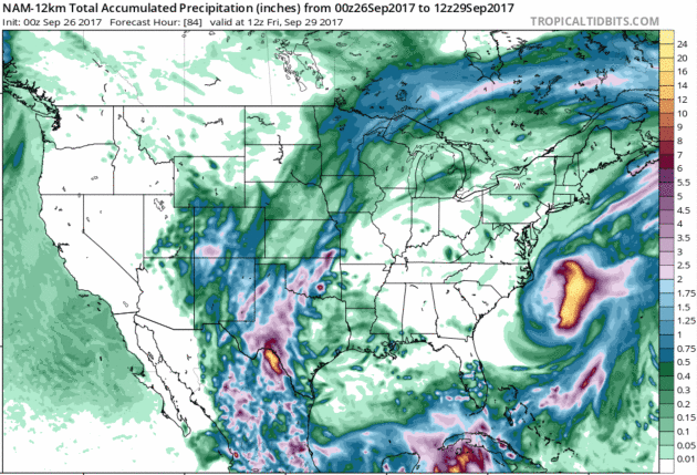
84-Hour Rainfall Outlook. Maria finally veers out to sea after roughing up the Outer Banks of North Carolina. Elsewhere the heaviest rains are forecast to fall over west Texas, where some 4-8″+ amounts are possible by Friday morning. Map: NOAA and Tropicaltidbits.com.
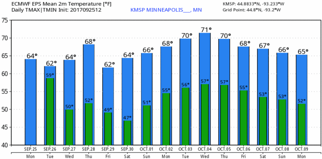
Close to Average. ECMWF forecasts data shows upper 60s and low 70s into next week – frost seems unlikely into mid-October, at least in the immediate Twin Cities metro area. Credit: WeatherBell.
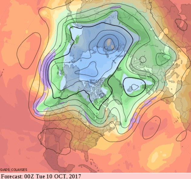
Easing Into Autumn. No cold blasts looking out 2 weeks, in fact GFS guidance hints at a cold, stormy trough of low pressure for the Pacific Northwest, while a warm ridge builds downwind over the Plains; summerlike warmth expected over roughly the southern half of the USA into mid-October.
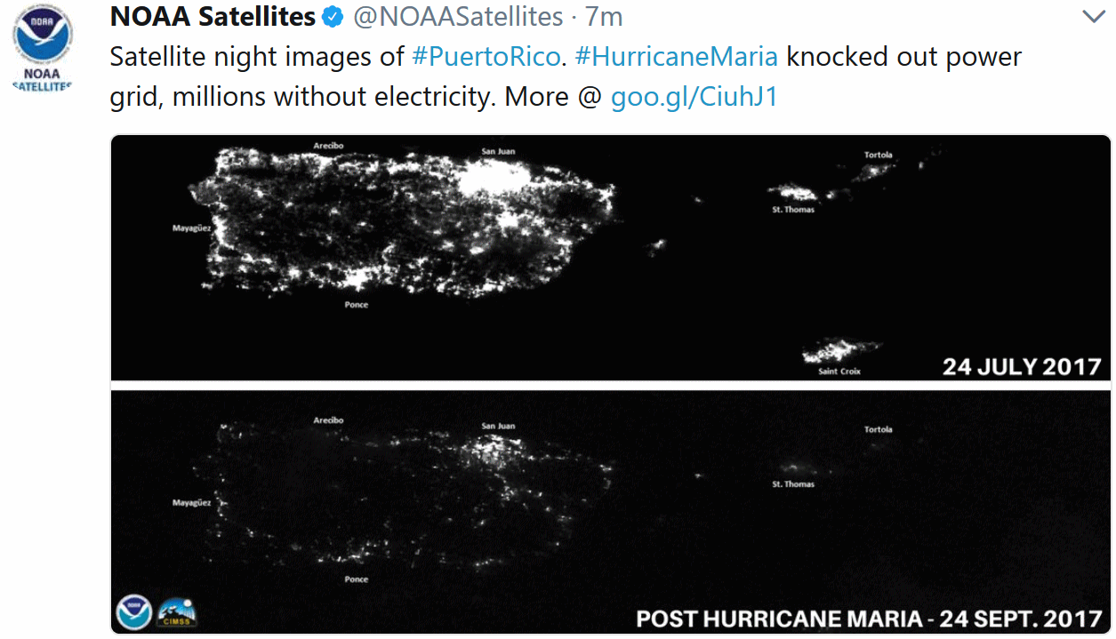
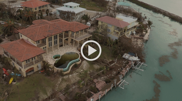
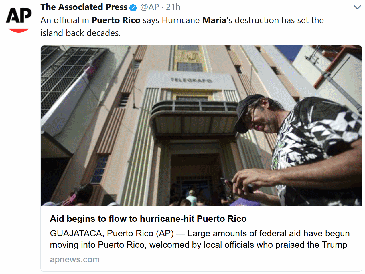
Puerto Rico’s Devastation Grows: Climate Nexus reports: “Puerto Rico’s humanitarian crisis continued to grow over the weekend, as officials describe “apocalyptic” conditions across the island in the wake of Hurricane Maria. Many of the 3.4 American citizens living on the island are without power and disconnected from communications, and officials estimate some areas won’t see power restored for months. Isolated towns and low-income communities are facing increasing shortages of supplies and fuel. Officials estimate the storm also destroyed around 80 percent of the island’s crop value, while a dam compromised by heavy rain is causing worries about flooding and accessibility of drinking water. “The devastation in Puerto Rico has set us back nearly 20 to 30 years,” Jenniffer Gonzalez, the island’s nonvoting representative in Congress, told the AP.” (Conditions: CNN, AP, Washington Post $, Bloomberg, New York Times $. Communications & power: NPR, Vox, NBC. Agriculture: New York Times $. Dam: New York Times $, Reuters, NBC, USA Today, CNN. Commentary: New York Times editorial $)

Praedictix Briefing: Issued Monday morning, September 25th, 2017:
*Maria continues to slowly weaken as the system moves northward. As of 8 AM ET Maria had sustained winds of 75 mph. The system is expected to weaken into a tropical storm within the next couple days.
*While it is very likely Maria will remain offshore the East Coast through the middle of the week, it could make a close brush with the Outer Banks by Wednesday. After that time, the system will sharply turn to the east and head out into the Atlantic.
*Due to the large wind field associated with Maria, tropical storm force winds will be possible along portions of the Outer Banks and eastern North Carolina, especially Tuesday into Wednesday. High surf, strong rip currents, and storm surge flooding will be possible along the sound side of the Outer Banks. Tropical Storm Watches and Warnings, along with Storm Surge Watches, are in effect.
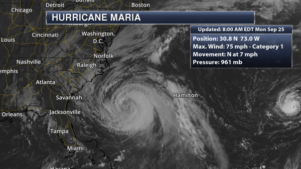
Maria Continues To Weaken. Maria has continued to weaken over the past 24 hours due to moderate wind shear aloft (helping to disrupt the system) and cooler water temperatures due to Jose. Maria is now a Category 1 hurricane with sustained winds of 75 mph as of this morning. The center of the storm is sitting 335 miles south-southeast of Cape Hatteras, NC, moving north at 7 mph. (Satellite data: AerisWeather)
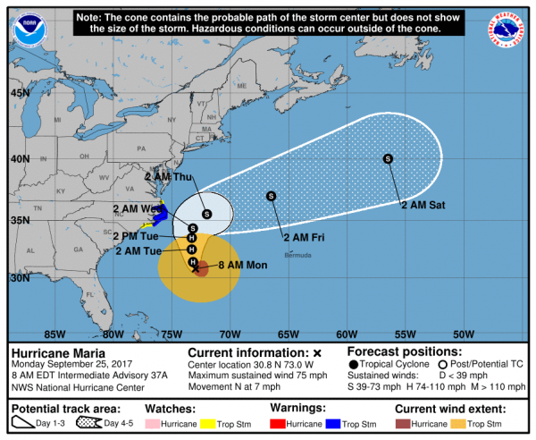
Maria Official Track. Maria will continue to move north over the next couple days, bringing the system close to the Outer Banks, although the worst of the system should remain offshore. Maria has a large wind field, with tropical storm force winds extending out 230 miles from the center of the storm. This means even if Maria does remain offshore, tropical storm conditions are possible, especially along the Outer Banks. During the middle of the week Maria is expected to take a sharp turn east, which will take the system further out into the Atlantic.
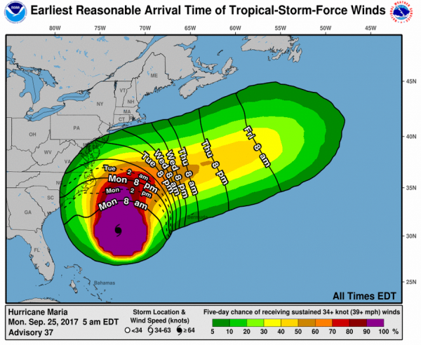
Timing Tropical Storm Force Winds. Tropical storm conditions will be possible starting later today across portions of the Outer Banks associated with Maria, but the highest likelihood of sustained tropical storm force winds will be Tuesday into Wednesday.
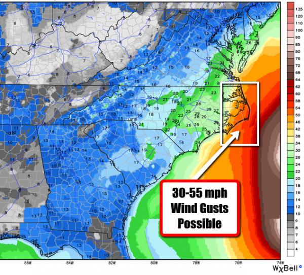
Wind Gusts Over 50 mph Possible. This is the official peak wind gust forecast from local National Weather Service offices (compiled together by WeatherBell) through Wednesday night. The winds are expected to be the strongest along parts of the Outer Banks, where wind gusts over 50 mph will be possible Tuesday into Wednesday. Areas further inland across eastern North Carolina have the potential of seeing wind gusts in the 20-30 mph range.
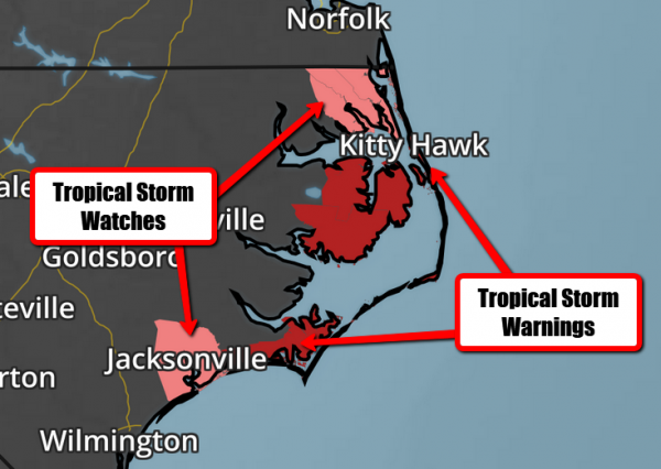
Tropical Storm Watches And Warnings. Mainly due to the potential of tropical storm force winds, Tropical Storm Watches and Warnings have been issued for portions of eastern North Carolina. Along the coast, they are in effect for the following locations:
A Tropical Storm Warning is in effect for…
* Cape Lookout to Duck
* Albemarle and Pamlico Sounds
A Tropical Storm Watch is in effect for…
* North of Duck to the North Carolina/Virginia border
* North of Surf City to south of Cape Lookout
Tropical statements from local National Weather Service offices: http://forecast.weather.gov/wwamap/wwatxtget.php?cwa=usa&wwa=Hurricane%20Local%20Statement

Forecast Storm Surge. We will watch the potential of storm surge flooding as well with Maria, especially along the sound side of the Outer Banks. We could see a water rise of 2-4 feet from Cape Lookout to Duck if the storm surge coincides with high tide. Due to this, a Storm Surge Watch is in effect for those areas.

Kitty Hawk High Tide Times. The highest potential of storm surge flooding will coincide with high tide, which will occur around midnight and noon on Tuesday and Wednesday.
Summary: While we aren’t anticipating Maria to make landfall along the East Coast, it may pass a little too close for comfort through the middle of the week. This will bring tropical storm conditions to parts of eastern North Carolina – particularly the Outer Banks – by Tuesday with winds gusting over 50 mph at times. Storm surge flooding will also be a concern, especially along the sound side of the Outer Banks if the rise in water coincides with high tide. Due to this, Storm Surge Watches are in effect from Cape Lookout to Duck.
Meteorologist D.J. Kayser, Praedictix


How Safe Is Your City from Natural Disasters? You Might Be Surprised. It’s impossible to remove all risk, but some metro areas are more disaster-prone than others, according to a story at realtor.com: “Mother Nature’s fury has been devastating—and deadly—over the past few weeks, with Hurricanes Harvey, Irma, and, now, Maria, as well as two powerful earthquakes in Mexico. And that’s just in North America. But despite the threats that natural disasters pose, U.S. property values in the areas most prone to them rose more than twice as quickly than in safer parts of the country over the past decade, according to a recent report from real estate data company ATTOM Data Solutions. Oklahoma City was rated the riskiest city in the country for natural disasters because of its tornadoes and a recent spate of earthquakes that scientists have linked to the local oil industry. Next on the danger list was a shocker: Silicon Valley’s San Jose, perennially one of the nation’s hottest and priciest real estate markets. Rounding out the top five were Los Angeles and Bakersfield, in California, and then Seattle…”
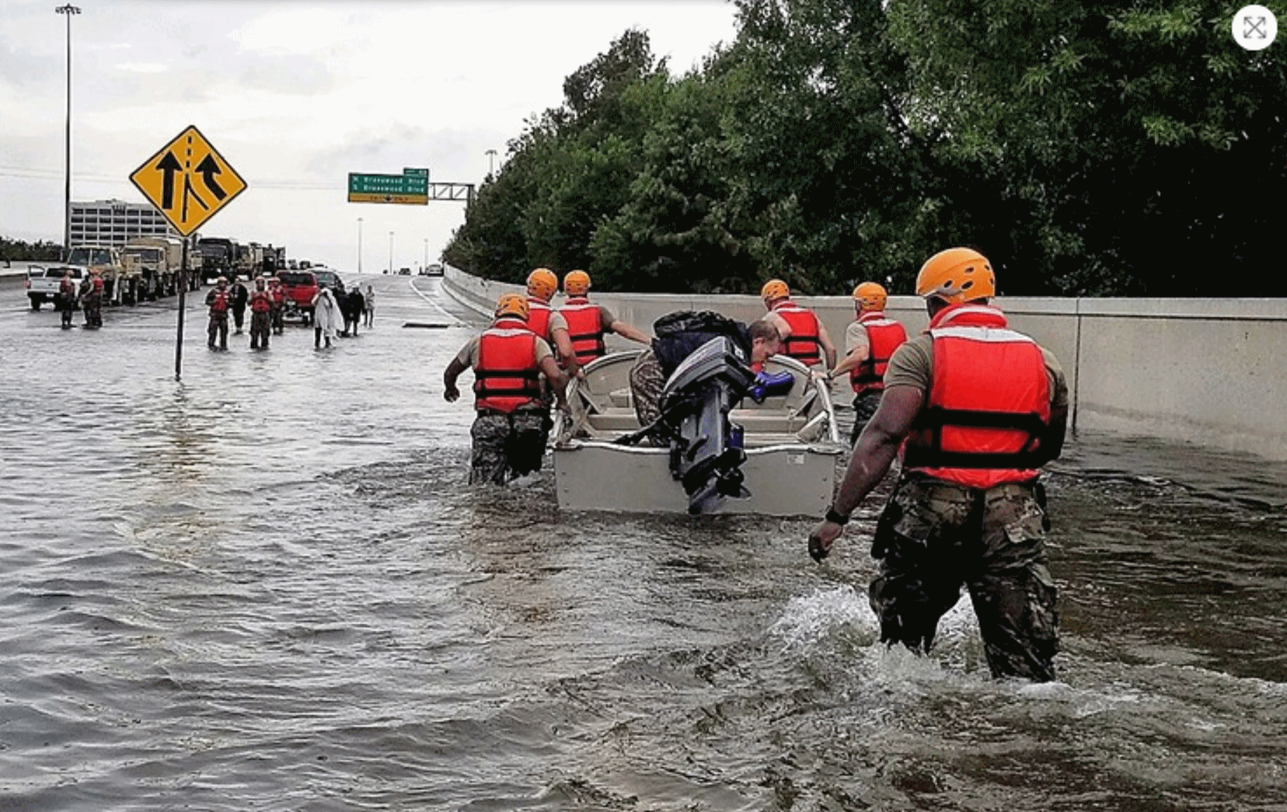
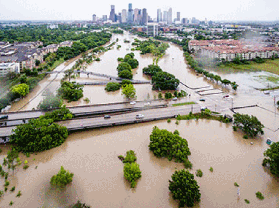
Harvey is Scaring Houston Straight on Flood Safety, But Dallas May Take Longer. The Dallas Observer has some interesting perspective on flood risk in Dallas: “…We have the same system, only more dangerous. If only one of our immense regional reservoirs fails, the toll in human lives would be staggering. As a special project in The Dallas Morning News by George Getschow revealed two years ago, a failure of the aged and decaying Lake Lewisville Dam would put 431,000 lives in immediate jeopardy. An upstream dam failure at any of the three major reservoirs that flow directly into downtown Dallas must be stacked against the old and rickety system of flood safety levees along the Trinity River through downtown. In 2009, the Corps of Engineers rated that entire levee system as “unacceptable,” the most stupidly abused term in contemporary public double-speak. What they really meant was, “no good,” “unsafe,” “won’t do the job,” “grab your water-wings and paddle as fast as you can…”
Photo credit: “Harvey taught Houston that the things it had been told before about flood safety simply were not true.” U.S. Army photo by 1st Lt. Zachary West.
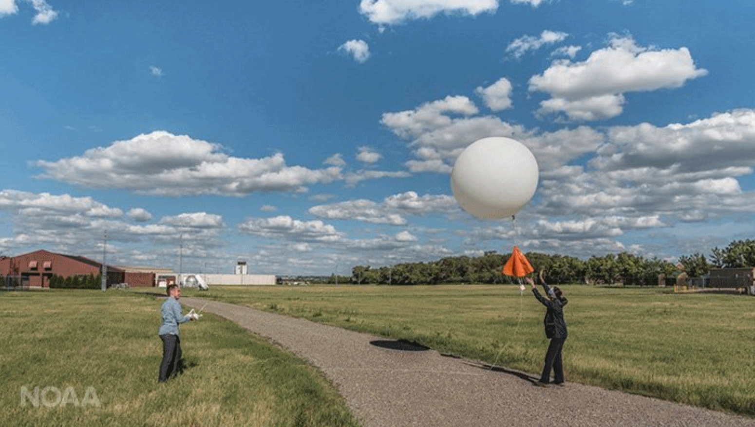
Upper Air Observations: How Weather Balloons Improve Forecasts. Satellites derive wind, moisture and temperature – with weather balloons you get real measurements of the atmosphere in real-time. NOAA explains: “…The radiosondes allow the direct measurement of the upper atmosphere as opposed to the indirect remote sensing techniques employed by satellites or ground-based remote sensing instrumentation. As a result, these observational data are more accurate and reliable than indirect data types. The combination of the two allows for the best forecasts, ensuring public safety in the event of an approaching storm. “Models initialized with good data can provide better and more certain forecast information,” said Aberson. “When the forecast is difficult or different models disagree, more frequent radiosonde observations are requested. This is likely to improve how accurate the forecasts are.”
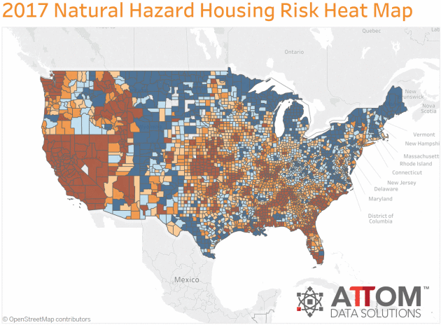
How Prices Rising Twice as Fast in U.S. Cities with Highest Natural Hazard Risk Than in Lowest-Risk Cities. Research conducted by ATTOM Data Solutions was the basis for the realtor.com story above. Here’s an excerpt: “…Among the 735 U.S. counties included in the housing trends analysis, those with the highest overall natural hazard index were Oklahoma County, Oklahoma; Wakulla County (Tallahassee), Florida; Monroe County (Key West), Florida; Cleveland County (Oklahoma City), Oklahoma; and Nevada County (Truckee), California. Among 50 U.S. cities included in the analysis with a population of at least 500,000, those with the highest overall natural hazard housing risk index were Oklahoma City, Oklahoma; San Jose, California; Los Angeles, California; Bakersfield, California; and Seattle, Washington. Among the 735 U.S. counties included in the housing trends analysis, those with the lowest overall natural hazard index were Milwaukee County (Milwaukee), Wisconsin; Cuyahoga County (Cleveland), Ohio; Muskegon County (Muskegon), Michigan; and Lake County (Cleveland), Ohio...”
How Safe Is Your City from Natural Disasters? You Might Be Surprised. It’s impossible to remove all risk, but some metro areas are more disaster-prone than others, according to a story at realtor.com: “Mother Nature’s fury has been devastating—and deadly—over the past few weeks, with Hurricanes Harvey, Irma, and, now, Maria, as well as two powerful earthquakes in Mexico. And that’s just in North America. But despite the threats that natural disasters pose, U.S. property values in the areas most prone to them rose more than twice as quickly than in safer parts of the country over the past decade, according to a recent report from real estate data company ATTOM Data Solutions. Oklahoma City was rated the riskiest city in the country for natural disasters because of its tornadoes and a recent spate of earthquakes that scientists have linked to the local oil industry. Next on the danger list was a shocker: Silicon Valley’s San Jose, perennially one of the nation’s hottest and priciest real estate markets. Rounding out the top five were Los Angeles and Bakersfield, in California, and then Seattle…”
How Prices Rising Twice as Fast in U.S. Cities with Highest Natural Hazard Risk Than in Lowest-Risk Cities. Research conducted by ATTOM Data Solutions was the basis for the realtor.com story above. Here’s an excerpt: “…Among the 735 U.S. counties included in the housing trends analysis, those with the highest overall natural hazard index were Oklahoma County, Oklahoma; Wakulla County (Tallahassee), Florida; Monroe County (Key West), Florida; Cleveland County (Oklahoma City), Oklahoma; and Nevada County (Truckee), California. Among 50 U.S. cities included in the analysis with a population of at least 500,000, those with the highest overall natural hazard housing risk index were Oklahoma City, Oklahoma; San Jose, California; Los Angeles, California; Bakersfield, California; and Seattle, Washington. Among the 735 U.S. counties included in the housing trends analysis, those with the lowest overall natural hazard index were Milwaukee County (Milwaukee), Wisconsin; Cuyahoga County (Cleveland), Ohio; Muskegon County (Muskegon), Michigan; and Lake County (Cleveland), Ohio...”
What Would An Entirely Flood-Proof City Look Like? The Guardian imagines how cities may be forced to reinvent themselves in the years ahead: “They call it “pave, pipe, and pump”: the mentality that has dominated urban development for over a century. Along with the explosion of the motorcar in the early 20th century came paved surfaces. Rainwater – instead of being sucked up by plants, evaporating, or filtering through the ground back to rivers and lakes – was suddenly forced to slide over pavements and roads into drains, pipes and sewers. Their maximum capacities are based on scenarios such as 10-year storms. And once they clog, the water – with nowhere else to go – simply rises. The reality of climate change and more frequent and intense downpours has exposed the hubris of this approach. As the recent floods from Bangladesh to Texas show, it’s not just the unprecedented magnitude of storms that can cause disaster: it’s urbanisation…”
File photo credit: Jordan Anderson, DoubleHorn Photography.

![]() Oklahoma City was rated the riskiest city in the country for natural disasters because of its tornadoes and a recent spate of earthquakes that scientists have linked to the local oil industry. Next on the danger list was a shocker: Silicon Valley’s San Jose, perennially one of the nation’s hottest and priciest real estate markets. Rounding out the top five were Los Angeles and Bakersfield, in California, and then Seattle.
Oklahoma City was rated the riskiest city in the country for natural disasters because of its tornadoes and a recent spate of earthquakes that scientists have linked to the local oil industry. Next on the danger list was a shocker: Silicon Valley’s San Jose, perennially one of the nation’s hottest and priciest real estate markets. Rounding out the top five were Los Angeles and Bakersfield, in California, and then Seattle.


THURSDAY: Sunny start, late PM shower risk. Winds: NW 7-12. Wake-up: 52. High: 70
FRIDAY: Blue sky, a fresh breeze. Winds: N 5-10. Wake-up: 49. High: 65
SATURDAY: Partly sunny, a bit milder – nicer day of the weekend. Winds: SE 8-13. Wake-up: 48. High: 69
SUNDAY: More clouds, showers break out. Winds: SE 10-15. Wake-up: 52. High: 72
MONDAY: Showers likely, possible T-storms. Winds: SW 10-15. Wake-up: 56. High: 68


Millenials Think About Climate Change Differently Than Anyone Else. Because deep down they realize they are the generation that will be cleaning up our messes; here’s a clip from mindbodygreen.com: “…Millennials are fervent believers that climate change is an issue that needs to be dealt with, and 82 percent of them are concerned about how it will influence their children’s quality of life. But for many, this concern seems to have morphed into a slight helplessness. Nowadays, millennials are doubting their ability to make a dent in such a huge issue and are instead choosing to support companies that have a larger perceived impact. Therefore, they seek out companies that value environmental stewardship and employee treatment practices, even going so far as to prioritize these values above their product’s efficiency. According to data, young people are skeptical of many large corporations, but once they find one they trust, they put a lot of faith into it. Some of their top picks for eco-minded companies include Patagonia, Whole Foods, Tesla, and The Honest Company…”
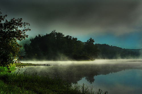
Photo credit: Saptak Ganguly.