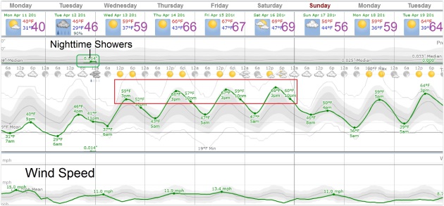
59 F. high in the Twin Cities Sunday.
55 F. average high on April 10.
56 F. high temperature on April 10, 2015.
April 11, 1929: An intense downpour occurs in Lynd, Minnesota (near Marshall), where 5.27 inches of rain would fall in 24 hours.
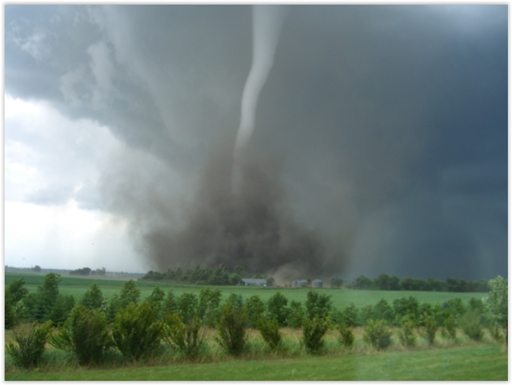
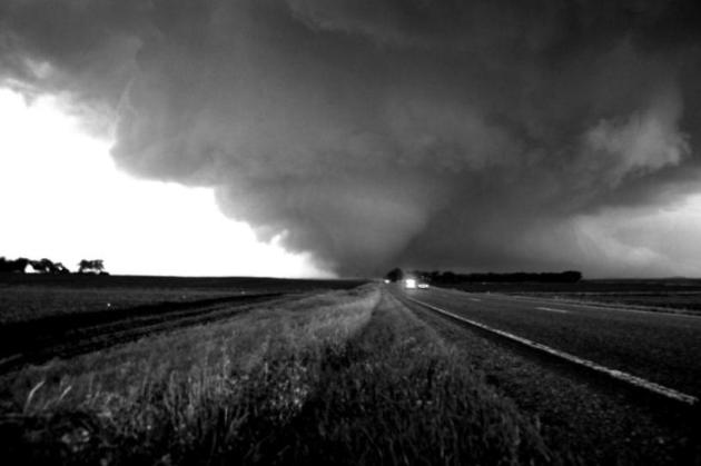
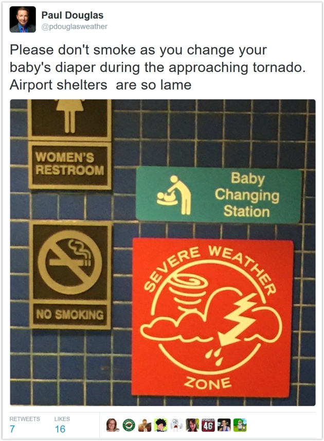
This is Severe Weather Awareness Week in Minnesota
Truth: you stand a better chance of sharing Sunday brunch with Prince than you do of seeing a devastating EF-4 tornado. Yet every year waves of severe thunderstorms sweep across Minnesota, sparking violent winds, large hail, flash flooding and lightning.
After 40 years of tracking storms here’s my best advice: buy a NOAA Weather Radio. Nothing else will wake you up at 3 AM when severe storms are blowing through. Load up a few weather apps on your smartphone. For a few thousand dollars you can turn a closet into a reinforced, tornado-proof storm shelter. Don’t rely on sirens (created for outdoor use only) or social media, where it’s easy to get misinformation.
No big storms are in sight into next week as dry weather prevails. A cool wind today gives way to a lukewarm Pacific breeze 60s return by Wednesday with a shot at 70F by late week. I predict a raging rash of spring fever within 72 hours.
According to NOAA SPC Minnesota sees an average of 36 tornadoes every year. 24 were observed in 2015, but 2010 saw 145 twisters in the Gopher State; most in the USA.
Be a good Boy Scout. Be Prepared.

Those Twins Hoodie Sweatshirts May Come In Handy Today. What a deal! The first 30,000 Twins fans get a hoodie sweatshirt this afternoon, which may come in handy with air temperatures in the upper 30s and a chill factor in the 20s. More details via Facebook: “See our Minnesota Twins as they kick off their season at Target Field April 11 against the Chicago White Sox. First 30,000 fans receive a Twins hoodie sweatshirt. To purchase tickets, visit http://minnesota.twins.mlb.com/schedule/?c_id=min#y=2016&m=4&calendar=DEFAULT...”
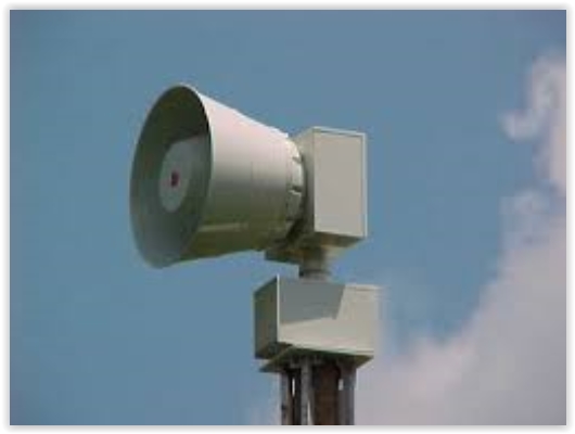
Siren Test on Thursday. Here’s an excerpt from Homeland Security and Emergency Management: “…The most important events during Severe Weather Awareness Week are the two annual statewide tornado drills. These drills are scheduled for Thursday, April 14, 2016 at 1:45 p.m. and 6:55 p.m. (Counties may chose to opt out of the drills if actual severe weather is possible in the area). Outdoor warning sirens and NOAA Weather Radios will sound in a simulated tornado warning. The first drill is intended for institutions and businesses. The evening drill is intended for second shift workers and families…
- Tuesday — Severe Weather, Lightning and Hail
- Wednesday — Floods
- Thursday — Tornadoes (with statewide tornado drills)
- Friday — Extreme Heat

Good Advice. Here’s an excerpt of some timely tips from GEICO at businesswire.com:
- Store important documents in a safe location – Consider investing in a safe box to store your important documents, photos and other valuables.
- Create a home inventory – Keep an up-to-date inventory of all items in your home. Include photos of valuables such as electronics and jewelry. This may help speed up the claims process if damage occurs as a result of the storm.
- Review your insurance coverage – Contact your insurance carrier to find out if you’re fully protected. Use your home inventory to help determine if you have purchased enough insurance.
- Pay attention to weather alerts – Be aware of weather alerts and updates. In the event that a tornado watch or tornado warning is issued, seek shelter immediately and follow any official instructions from local or national officials.


4 Rescued During Record-Breaking Rainfall in Las Vegas Valley. Storms in the southwest often portend a shift in the pattern for Minnesota (toward milder weather east of the trough). Here’s the intro to a story at The Las Vegas Review-Journal: “Four people were rescued from flood control channels and two from their vehicles Saturday as record-breaking rain fell and flash floods hit the Las Vegas Valley. The National Weather service extended a flash flood advisory warning to cover the entire valley until 6:30 p.m. Saturday, National Weather Service meteorologist Caleb Steele said. The waters from the the thunderstorms are “slow to recede,” he said. The record-breaking rainfall triggered flooding that resulted in several water rescues Saturday...”
Photo credit above: “The High Roller is reflected in a puddle at the Linq in Las Vegas on Saturday, April 9, 2016.” Brett Le Blanc/Las Vegas Review-Journal Follow @bleblancphoto.
* More details and perspective on the flooding around Las Vegas from The Weather Channel.
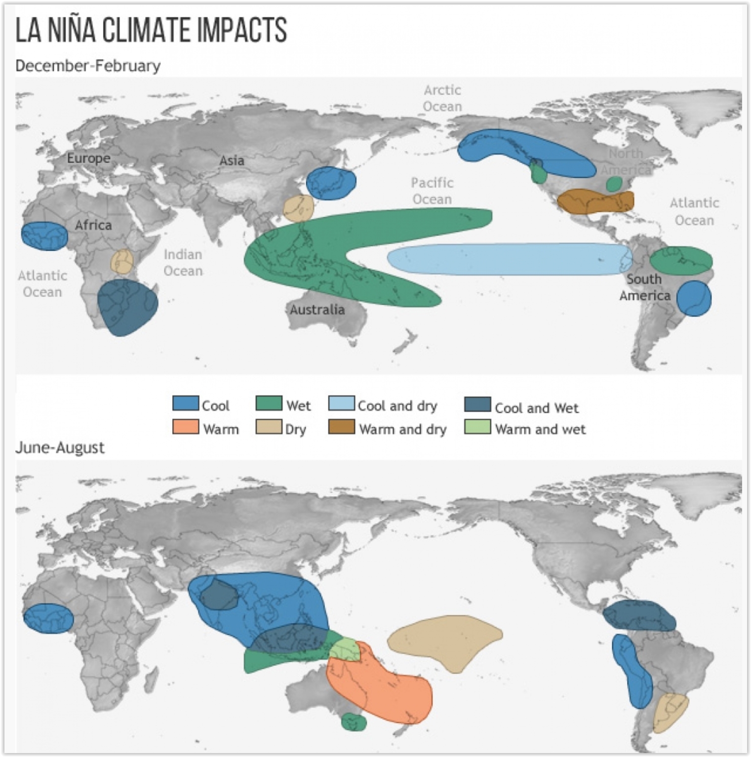
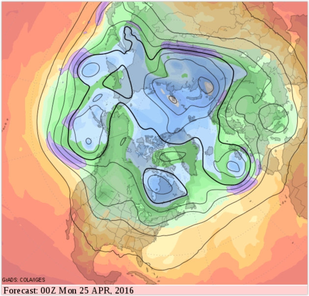
Will La Nina Follow One of the Strongest-Ever El Ninos? The odds are increasing, which (might) favor a more active hurricane season in the Atlantic, and a greater risk of drought for the Upper Midwest. Here’s an excerpt from Climate Central: “…The Rossby waves usually disrupt the El Niño pattern about six months after it peaks, or, right about now. Indeed, forecasters have noted a cool down below the surface of the eastern tropical Pacific in recent weeks, though surface water temperatures are still firmly in El Niño territory. They will gradually follow the subsurface cool-off, though, likely reaching neutral territory by late spring. If a La Niña is in the offing, those waters should be cooling further by mid-summer, though, like El Niño, it wouldn’t peak until late fall or early winter. Right now Barnston puts the odds at slightly better than 50 percent that a La Niña does develop…” (Image credit: NOAA climate.gov).

A Super-Drone You Can Fly In? Coming soon to the skies above Minnesota? Fox News has the story and video (which you have to see). Here’s the intro: “German copter company E-Volo still has its CEO. Not that engineers had any doubts about the safety of the Volocopter’s recent first-ever manned flight, which the company’s boss bravely piloted. The extraordinary drone-helicopter hybrid is essentially a two-seat flying machine that gets off the ground with the help of what looks like a large number of drones that’ve been welded together. The “super drone” is powered by an electric engine, with precision control offered by little more than a joystick with a few buttons it...”
Photo credit above: Volocopter VC200 (© e-volo, by Nikolay Kazakov).

Why Life is Beautiful, According to this 92-year-old Holocaust Survivor. Here’s a snippet from a Washington Post interview: “…Most people are never happy and complain too much. It’s too hot out, it’s too cold out. Life is beautiful. No need to complain so much. I think my outlook on life is different than most people, before and after the Holocaust. I’ve always had a love for life.” How did he manage to survive such horror? “Everyday you think of living,” he wrote. “We are born to die, but I appreciate life. We live day by day, and I always say: Yesterday is history, today’s reality, and tomorrow’s a dream...”
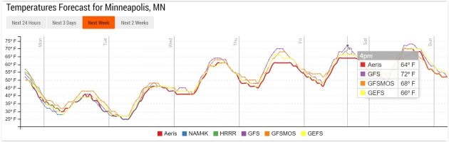
TODAY: Brisk with a mix of sun and clouds. Feels like 20s. Winds: NW 15-25. High: near 40
MONDAY NIGHT: Clear and frosty. Low: 26
TUESDAY: Bright sun, feeling better. Winds: S 8-13. High: 47
WEDNESDAY: Early shower or sprinkle, then mild sun. Winds: S 10-20. Wake-up: 39. High: 60
THURSDAY: Partly sunny, feeling feverish. Winds: S 15-25. Wake-up: 46. High: 68
FRIDAY: Intervals of sun, take a comp day. Winds: S 15-25. Wake-up: 51. High: near 70
SATURDAY: Some sun, T-shower risk western MN. Winds: SE 10-20. Wake-up: 52. High: 67
SUNDAY: Isolated shower, a bit cooler. Winds: N 8-13. Wake-up: 49. High: 63
Climate Stories…
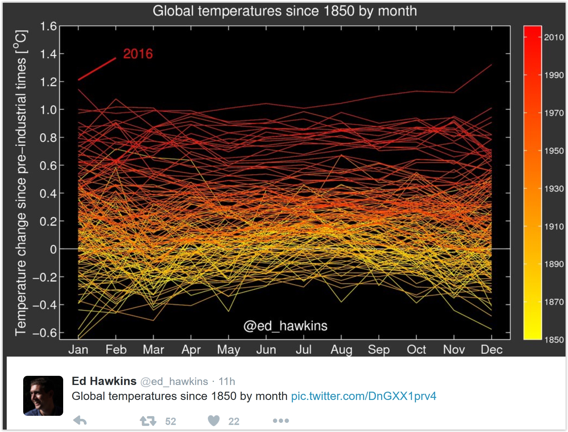

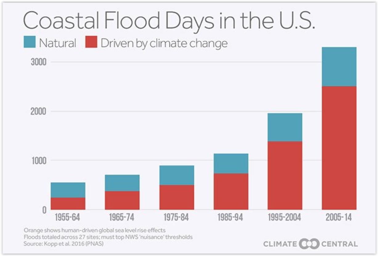
Oh Buoy, What’s Happening With Sea-Level Rise? Here’s an excerpt from a good summary from The Climate Reality Project: “…Carbon pollution from fossil fuel burning and industry is at an all-time high, and both atmospheric carbon dioxide levels and global temperatures have increased dramatically since the Industrial Revolution. Carbon pollution traps more and more heat in our atmosphere, and these warmer temperatures cause glaciers to melt and sea water to expand – leading to sea-level rise. Sea levels are rising faster than at any time in almost 3,000 years – and the reason why is clear: human-caused climate change…” (Graphic credit: Climate Central).
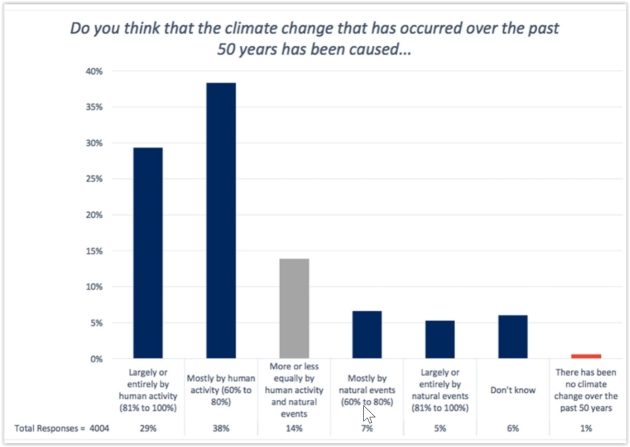
Why Do Most Meteorologists Still Doubt Humans Are The Dominant Cause of Climate Change? Here’s an excerpf of an Eric Holthaus story at Slate: “…That new survey found just 29 percent of AMS members agreed with the stricter wording of the scientific consensus that climate change has been caused “largely or entirely by human activity.” This intense skepticism is worrying: Some of these meteorologists have big audiences that trust them for life-and-death advice during extreme weather. That they choose not to link those events, when appropriate, to human actions is a disservice to their science and to those who depend on them—and in fact, it may partially explain the public’s lack of acceptance of climate science…”
Graphic credit above: George Mason University, Center for Climate Change Communication.
