Tropical Systems And Minnesota
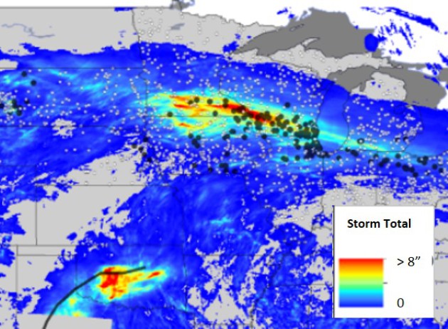
With Harvey in the mind of some, there is always the question of whether a tropical system has hit Minnesota. Well, the answer is no… but they can affect our weather and bring us moisture. More from the Minnesota Climatological Society: “Landfalling tropical weather systems move tremendous amounts of moisture inland. This moisture takes the form of not only the heavy rainfall we associate with hurricanes and tropical storms, but also of exceptionally rich and deep humidity. The weak winds aloft found in the southern US during summer often keep that moisture concentrated over roughly the same region for days on end. The most common effect we see in the Upper Midwest, is that a passing weather system will draw in some of that remnant moisture and increase our cloudiness or precipitation modestly. When conditions are right, however, the remnant tropical moisture can interact with existing ingredients for rain and thunderstorms to create, intensify, and sustain a band of sometimes incomprehensibly-heavy precipitation.” (Image: 48-hour rainfall totals ending 6 PM August 20, 2007, in association with the remnant moisture and airflows from Tropical Storm Erin (path of center shown in lower left of image). Modified from Rowe and Villarini (2013).)
_______________________________________________
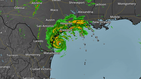
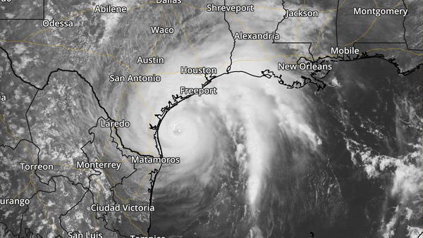
Harvey On Radar And Satellite Just Before Landfall
These satellite and radar loops end at approximately 5:30 PM Friday, right as Harvey was approaching land.
Already Beach Flooding Early Friday In Texas From Harvey
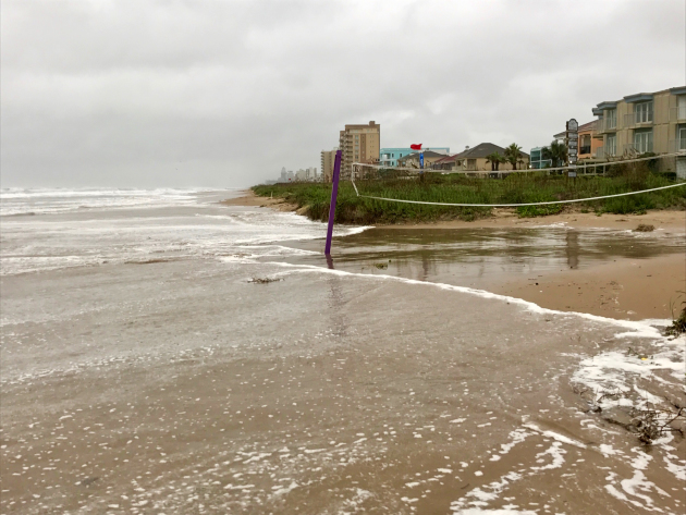
This was the view earlier Friday from the South Padre Beach camera, showing water flowing up on to the beach ahead of Harvey.
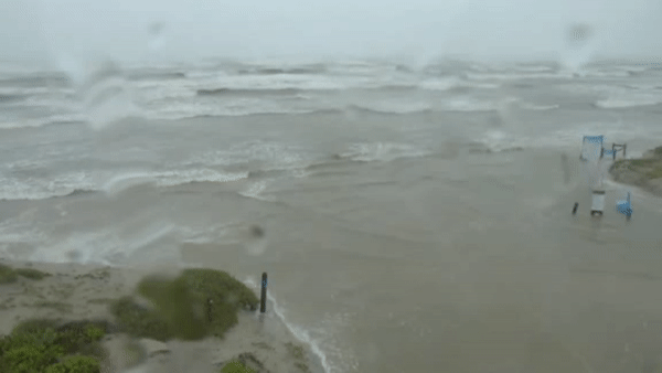
Harvey was also causing beach flooding and some storm surge already in the Corpus Christi area as well, as viewed on their Whitecap Beach webcam. More on Harvey below.
_______________________________________________
Harvey Will Be A Long-Duration Weather Disaster
By Paul Douglas
Size matters, so does speed. It’s easy to fixate on wind speed and storm surge, but 9 out of 10 deaths in a tropical storm or hurricane are the result of inland flooding.
Hurricane Harvey will stall over coastal Texas for the better part of a week. After surging inland toward San Antonio a few models suggest a U-turn, bringing the core of the storm over warm Gulf of Mexico water next week, meaning a steady fire-hose of moisture. Some 20-45 inch rainfall amounts are possible by next weekend.
Meteorologists are prone to hype, but NOAA government forecasters are tossing around words like “unprecedented”, “life-threatening” and “uninhabitable”.
Austin may see serious flooding, but Houston is uniquely vulnerable; they paved over a swamp. I foresee an extended, slow-motion weather disaster.
It puts today’s showers & T-storm into perspective. 1-2 inches of rain may fall today, but Sunday looks drier with enough sun for 70s – maybe a pop-up PM shower. 80s return the latter half of next week.
Don’t pack away shorts and flip-flops just yet. Plenty of summer left in September!
_______________________________________________
Extended Twin Cities Forecast
SATURDAY: Showers, heavy T-storms. High 69. Low 60. Chance of rain 90%. Wind SE 10-15 mph.
SUNDAY: Some sun, pop-up PM shower. High 73. Low 59. Chance of rain 40%. Wind NW 8-13 mph.
MONDAY: Mix of clouds and sun, comfortable. High 72. Low 57. Chance of rain 20%. Wind N 5-10 mph.
TUESDAY: Plenty of mild sun, light winds. High 77. Low 60. Chance of rain 10%. Wind SW 3-8 mph.
WEDNESDAY: Warm sun, few complaints. High 81. Low 62. Chance of rain 20%. Wind S 5-10 mph.
THURSDAY: Some sticky sun, isolated T-shower. High 80. Low 64. Chance of rain 30%. Wind SE 5-10 mph.
FRIDAY: Warm sun, noticeable humidity. High 84. Low 66. Chance of rain 20%. Wind S 10-15 mph.
_______________________________________________
This Day in Weather History
August 26th
1915: Unseasonably cold air leads to killing frosts across Minnesota, with a low of 23 degrees at Roseau.
_______________________________________________
Average Temperatures & Precipitation for Minneapolis
August 26th
Average High: 79F (Record: 97F set in 2013)
Average Low: 60F (Record: 44F set in 1968)
Average Precipitation: 0.12″ (Record: 2.04″ set in 2005)
________________________________________________
Sunrise/Sunset Times for Minneapolis
August 26th
Sunrise: 6:28 AM
Sunset: 8:00 PM
*Length Of Day: 13 hours, 31 minutes and 58 seconds
*Daylight Lost Since Yesterday: ~2 minute and 57 seconds
*Next Sunrise At/After 6:30 AM: August 28th (6:30 AM)
*Next Sunset At/Before 8 PM: August 26th (8:00 PM)
_______________________________________________
Minnesota Weather Outlook
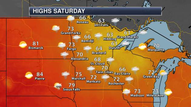
Unfortunately for those heading out to the state fair Saturday, it does look like it will be a wet and cool day across the region. Highs will attempt to make it to 70 here in the Twin Cities, but we will certainly not make it out of the 60s across parts of central and northern Minnesota with rain expected. It definitely won’t feel like late August!

Highs will be a good 5-15 degrees below average for this time of year across the state with the clouds and rain around.
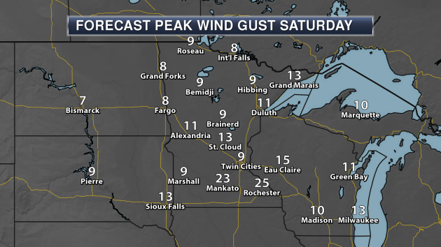
There could even be a little bit of a chill with the wind, especially across southern Minnesota where gusts could be in the 20 mph range.
While we do see a warm up toward the middle and end of next week, highs look like they will remain below 90 as we head through the end of August into the beginning of September. These warmer highs could depend on what Harvey does as we head into next week.
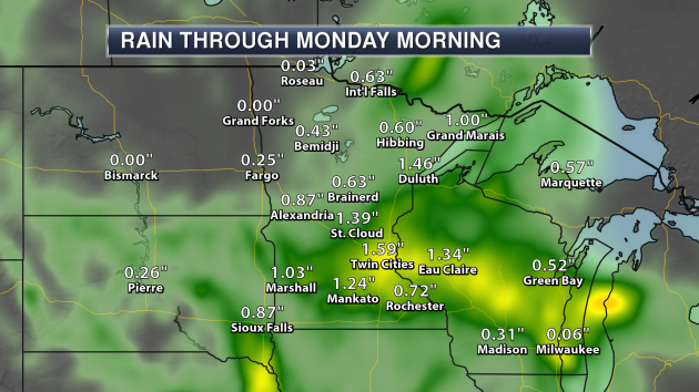
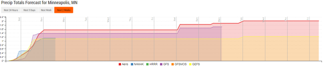
With heavy rain moving in Saturday, rainfall amounts through the weekend could top 1″, especially across southern Minnesota. We could even see rainfall rates of 1-2″ per hour during some of the heaviest rain. The good news is that the weather for Sunday looks better, with just a slight (20%) chance of rain.
After we get through the rain this weekend, the next chance of rain doesn’t move into the Twin Cities until late next week.
_______________________________________________
Latest On Harvey
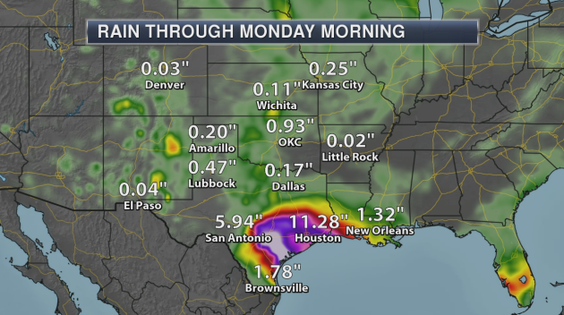
Harvey will bring very heavy rainfall to the Texas coast as the system makes landfall and essentially stalls out as we head through the weekend before slowly moving east. By Monday morning, Houston could see over 11″ of rain, but areas closer to Corpus Christi could see the potential of 15″+.
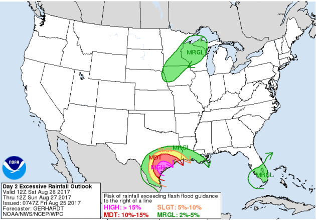
With the heavy rain expected from Harvey, flash flooding is highly likely – and in some areas it could be catastrophic. The Weather Prediction Center has a HIGH potential of excessive rainfall leading to flooding in and around the Corpus Christi area Saturday.
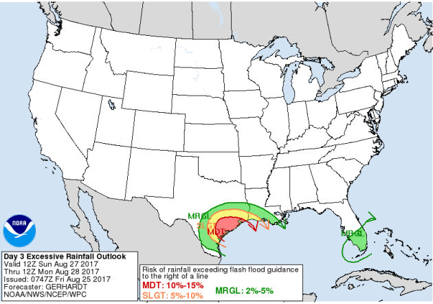
The heavy rain and flood threat continues along the central/northern Texas coast into Sunday, with a MODERATE potential of excessive rainfall leading to flooding. Note that three days out (this forecast was issued Friday) the Weather Prediction Center does not issue a high risk.
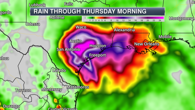
Since the system is going to be very slow to move east or northeast into next week, rain will continue across parts of Texas into the middle of next week. That means some areas could pick up over two (maybe even three) feet of rain in the next week. Heavy rain will continue to spread into parts of Louisiana into next week, with rainfall amounts of 7-15″+ possible through the middle of next week.
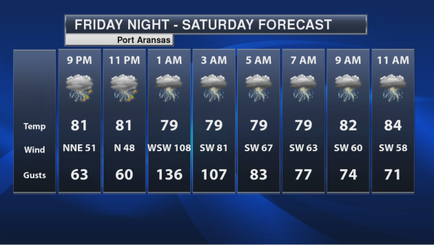
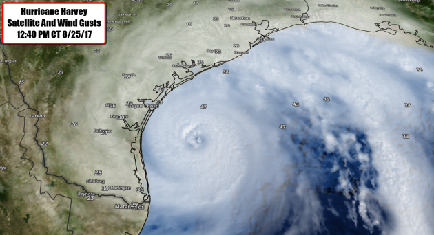
As Harvey makes landfall on the Texas coast late Friday Night, winds will quickly increase, with wind gusts potentially over 130 mph in the Port Aransas area.
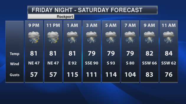
Those winds will also increase in Rockport, TX, with wind gusts over 110 mph during the overnight hour Friday into early Saturday morning.
The “Euro Special”
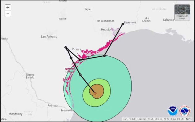
(Note: the path shown here was from the 10 AM CT Friday NHC update)
That’s the term that Eric Berger at Space City Weather has coined about the potential of Harvey making landfall, then eventually reemerging into the Gulf of Mexico. What impact could Harvey have on Houston and Galveston if that were to happen? More from the Space City Weather blog: “If you’ve read this site carefully over the last 24 hours, you’ll recall that I’ve been discussing a scenario I’m calling the “Euro special.” (See, for example, here and here). Under this scenario, Harvey makes landfall along the central Texas coast, dithers around for a day or two, and then moves eastward, back over the Gulf of Mexico. During its latest run the GFS model latched onto this scenario, bringing Harvey back into the Gulf, before the system eventually moves north-northeast toward Houston or Beaumont, getting drawn toward a trough of low pressure in the Midwestern United States.”
Flood Insurance And Harvey
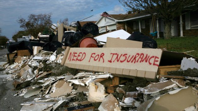
Will people be able to get help from the National Flood Insurance Program after Harvey hits Texas? The program is about $24 billion in debt. More from Mother Jones: “Once the storm has passed and residents begin to clean up, they will likely use a federal program to make insurance claims. The National Flood Insurance Program (NFIP), created in 1968 and administered by the Federal Emergency Management Agency, is a federal program designed to help people in flood-prone areas get insurance for their properties, at heavily discounted rates. As Mother Jones reported in 2013: “Today, the Property Casualty Insurers Association of America estimates that homeowners covered by federal flood insurance pay just half of the “true-risk cost” to insure their properties. In the highest-risk areas, they pay just a third.” A series of disasters has left the NFIP struggling financially. Hurricane Katrina and Superstorm Sandy devastated the flood insurance program’s budget and today, the program is about $24 billion in debt. As climate change fuels an increase in disasters, storms of the same caliber may become the norm.” (Image: Melanie Burford/Zuma)
FiveThirtyEight: Listen To The Meteorologists
(Image: AerisWeather)
Some good advice, I would say. FiveThirtyEight goes into detail about what the expected storm surge (up to 12 feet in spots) could mean: “A 2016 investigative series by The Texas Tribune, ProPublica and Reveal detailed why a high storm surge and heavy rain may be particularly devastating along Texas’s Gulf Coast. In recent years, intense, rare flooding has frequently hit areas outside of officially designated floodplains. The people who live in those areas aren’t required to have flood insurance, which can leave them in dire financial circumstances after the rains come. Even those who are covered buy their flood insurance from a federal program that’s deeply in debt after decades of charging rates that don’t reflect the true risk of flooding. Scientists believe that climate change, which is causing more frequent and more intense storms, has led to a growing risk of catastrophic flooding in the area, a risk further intensified by an increase in urban development, which has paved over prairie lands that were previously able to absorb some of the water.”
_______________________________________________
National Weather Outlook
Saturday’s Forecast
Besides tracking Harvey through Saturday, bringing heavy rain to parts of Texas and Louisiana, we are tracking a few other stories as well. Saturday will be a rainy day across the Northern Plains as a low pressure center moves through, bringing showers and storms along with it. A frontal boundary along with a tropical disturbance will help bring rain to parts of Florida, meanwhile the rest of the east coast looks nice weather-wise. Besides some monsoonal storms across the southwest (mainly in mountainous regions) parts of the region will be getting ready for a warm up for the second half of the weekend into next week.
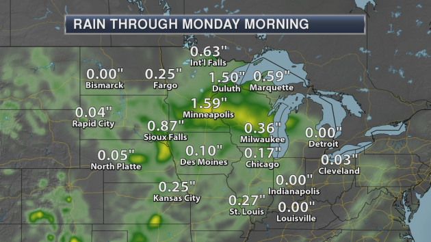
Through the weekend, parts of the Northern Plains could pick up over an inch of rain as that system moves through the region. Unfortunately Saturday does look quite wet across parts of the region – not something people want to see as they enjoy one of the last weekends of the summer.
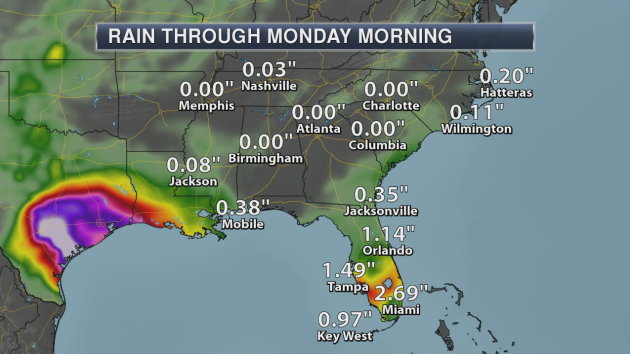
It’ll also be a wet weekend in the Southeast, where we see a front moving through as well as an unorganized tropical system (which could become better organized once it moves into the Atlantic). That could bring 1-3″+ of rain across the region through the weekend. A Flash Flood Watch is in effect for parts of southern Florida.
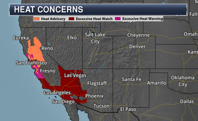
Meanwhile, heat is expected to expand into the weekend across the Southwest. Numerous Excessive Heat Watches/Warnings and Heat Advisories are in effect from Sunday into early next week. Most of these areas will see highs in the 100s.
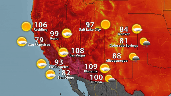
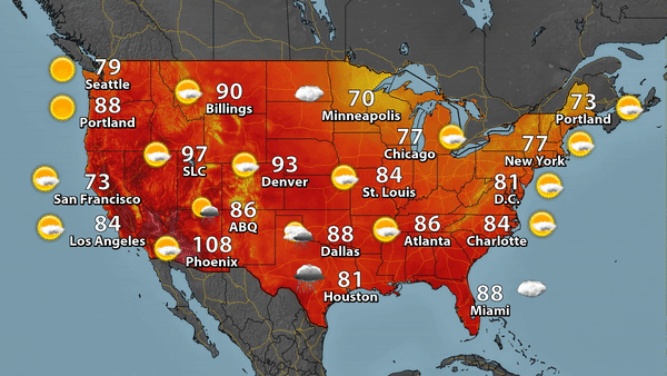
These are expected highs Sunday across the southwest, with areas like Las Vegas and Phoenix reaching the upper 100s.
_______________________________________________
Close Call During A Storm
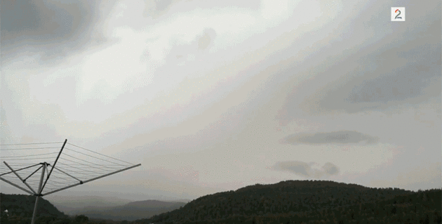
This is why we say to take cover in a storm. You never know where lightning is going to hit. More from Gizmodo: “The intense flash of light and booming crack of thunder that follows a lightning strike can be exhilarating, but it’s best to observe both while safely inside your home. As Norway’s Daniel Modøl discovered while filming a storm from his deck, those unpredictable lightning bolts can strike anywhere, even 16-feet from where you’re standing.”
Uranus The Next Diamond Farm?

Looking for a gift for your girlfriend or wife? Head to Uranus, which may be full of diamonds. I am being serious. More from Popular Science: “When subjected to the pressures (and temperatures) of life on other planets, even familiar substances can get pretty alien. Case in point: the diamond rains of the ice giants. Scientists have long thought that massive planets like Neptune and Uranus—which contain relatively tiny rocky cores covered with a mantle of slurried water, ammonia, and methane ices and surrounded by a thick atmosphere—are subject to rain made of literal diamonds. Now researchers have synthesized the process in a lab, showing how such conditions might occur.” (Image: NASA)
Nine States To Lower Pollution From Power Plants
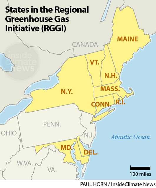
What the best part of this could be (in my opinion) is it is being done with bipartisan support. More from InsideClimateNews: “Nine eastern states announced Wednesday that they have agreed on a proposal to cut global-warming pollution from the region’s power plants an additional 30 percent between 2020 and 2030.”
_______________________________________________
Thanks for checking in and have a great Saturday! Don’t forget to follow me on Twitter (@dkayserwx) and like me on Facebook (Meteorologist D.J. Kayser)!
– D.J. Kayser

