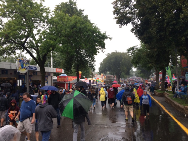
Soggy Saturday at the Fair…

The Great Minnesota Get Wet Together was a bit soggy on Saturday. A steady drizzle had many dawning their flashy umbrellas and ponchos. Despite the puddley mess, the food was great, it always is. Now I can start my diet and be ready for the next pig out on Thanksgiving…


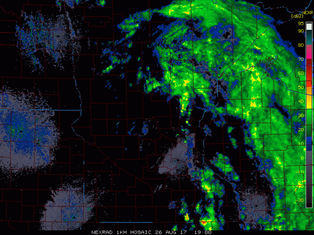
Radar Loop on Saturday

Here’s the radar loop from Saturday, which showed the steadiest rains across eastern and northeastern Minnesota, while a steady drizzle fell across much of the Twin Cities metro. The rain across the metro wasn’t all that heavy and it didn’t add up to much, but it sure made for a damp day.


Thunder Threat Sunday and Monday

According to NOAA’s SPC, there is a general thunderstorm risk across the eastern part of the state on Sunday. By Monday, the general thunderstorm risk shifts a little farther east into Wisconsin.

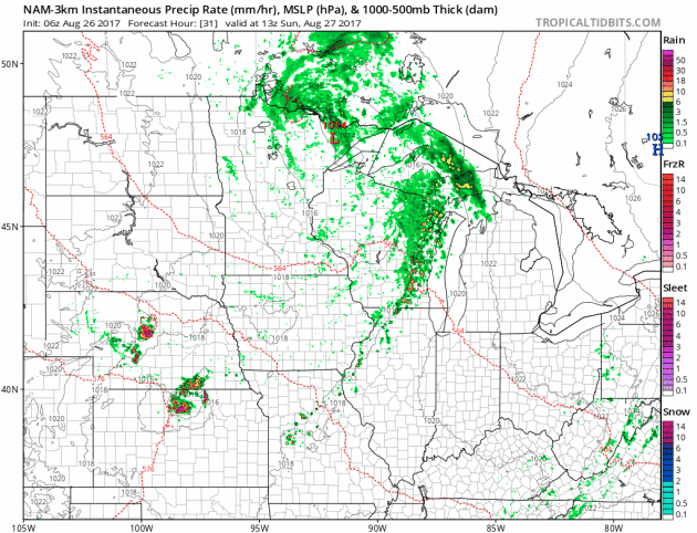
Simulated Radar Ahead…
Here’s the simulated radar from Sunday to Monday night, which shows a few isolated showers/storms trying to develop across the region on Sunday, but by Monday, the thunder threat moves farther east into Wisconsin.

Rainfall Potential Ahead

The rainfall forecast  through PM Monday shows pockets of heavier rainfall across eastern Minnesota and into northern Wisconsin. Some locations could see up to 1″ of rain or more.

_________________________________________________________

Rainfall Month To Date

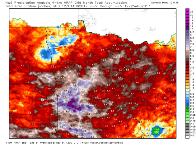
It has been a pretty wet month thus far with the Twin Cities seeing 5.28″ of rain through August 25th! That is nearly 2″ above average for the month! Note that some locations in western Minnesota have seen nearly 7″ to 10″+ of rain! So far this year, the Twin Cities has seen 24.18″ of liquid precipitation, which is nearly 3″ above average.

Precipitation Year to Date

Here’s a look at how much precipitation we’ve seen so far this year. Note that precipitation amounts are quite a bit higher as you go east into Wisconsin, while precipitation amounts fall considerably as you head west into the Dakotas. La Crosse, WI has seen nearly 31.74″ of precipitation this year, which is 8.56″ above average! However, Fargo, ND has seen only 10.46″ of precipitation this year, which is -5.05″ below average, while Minot, ND has seen only 5.33″ of precipitation this year, which is -7.73″ below average!


 US Drought Monitor

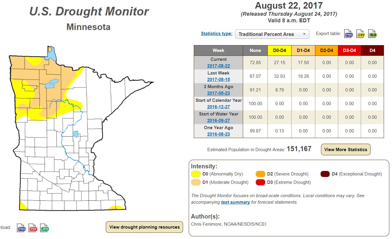
While much of the state has had appreciative rainfall this month and so far this year, parts of western and northwestern Minnesota are dealing with moderate drought and abnormally dry conditions. According to the US Drought Monitor, 17.5% of the state is considered to be in a moderate drought, which is down from the 18.25% last week. Note that 3 months ago, 0.00% of the state was in a moderate drought and only 8.79% was considered to be abnormally dry.


______________________________________________________

 Pollen Forecast

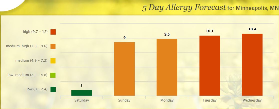
Itchy, sneezy? I tend to get a little more allergic to fall and I notice it more and more starting around State Fair time, which then finally starts to fade as the first frosts of the season start to arrive. With that said, according to pollen.com, the allergy forecast for Minneapolis suggests high to medium-high levels over the next few days. AHHH-CHOOO!!!

__________________________________________________________________
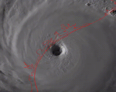
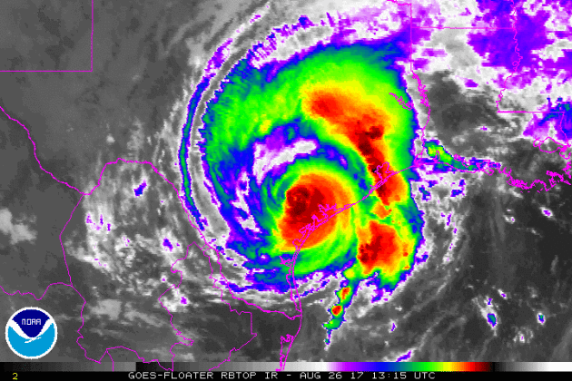
HARVEY Just Before Landfall on Friday
Here’s a visible satellite image loop of HARVEY just before landfall on Friday night. Note how impressive the eye was, which at this point was a category 4 storm with 130mph sustained winds.
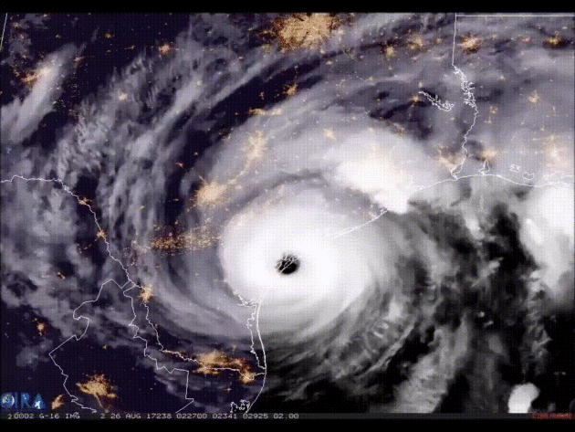
HARVEY From PM Friday to Saturday
Here’s an impressive satellite loop, which shows HARVEY as a major category 4 storm from Friday night to a tropical storm as of Saturday. While the significant wind threat is over, heavy rain is still expected to be the main threat.
 

Widespread Damage

The reports from Rockport, TX are bleak. Significant to catastrophic damage is being reported across much of the area and the storm isn’t over yet. While the strongest of winds have subsided, widespread flooding rains will continue across much of the region. Here’s a story from CNN about the storm
 
HARVEY Tornado Threat
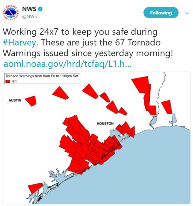
WOW! I’d say the NWS has been busy. This tweet was sent out Saturday afternoon, which showed all the tornado warnings that were issued across Texas since Friday. Unfortunately, additional tornadoes and flooding will be likley over the next few days.
 
HARVEY
Hurricane Harvey made landfall late Friday night near Port Aransas and Port O’Connor Texas as a Category 4 storm with sustained winds up to 140mph! Interestingly, this was the first category 4 storm to make landfall with the United States since Charlie in 2004. As of Saturday afternoon, HARVEY was a tropical storm with sustained winds of 65mph. While the strongest of winds is over, the catastrophic rain threat will continue through the rest of the weekend and into the week. This storm will bascially stall over the area and bring widespread heavy rainfall to many locations, some of which could see totals approaching 2ft to 3ft. !!

 Tracking HARVEY

Here’s the official track for HARVEY through the middle/end of next week, which shows stalling over Texas, which will help to prolong areas of heavy rain over the same areas over the next several days. Widespread flooding potential will continue over the next several days in these areas.
 
Simulated Radar
Here’s the simulated radar from Sunday to Monday night, which shows a very slow movement on HARVEY. This will help to prolong the tornado and catastrophic flooding threat over the next few days.


Heavy Rain Continues
Catastrophic flooding will still be likely over the next few days with some spots still seeing upwards of 2ft. to 3ft. or more, mainly across southern Texas. Areas like San Antonio, Austin, Corpus Christie, Houston and Galveston may see some of the heaviest tallies with up to 3ft.+ possible!
 Atlantic Outlook: Next 5 Days

Weather conditions in the Atlantic basin remain fairly active over the next few days with HARVEY continuing to bring significant rainfall to parts of Texas. NOAA’s NHC is also tracking a wave of energy over Florida that has a MODERATE chance of tropical development over the next few days, while a wave in the Central Atlantic has a LOW chance of development.

 
 Eastern Pacific Outlook: Next 5 Days

Things have been a little quieter in the Eastern Pacific. There are no active storms, but there is one wave of energy that has a MODERATE chance of tropical formation over the next 5 days.

 __________________________________________________________________________
PRELIMINARY 2017 Tornado Map

It certainly has been a fairly active first half of 2017 with 1263 preliminary tornado reports through August 18th. Note that this is the most tornadoes through August 18th since 2011, when there were 1,725 reports. The map below shows the distribution of the tornadoes so far this year.

PRELIMINARY 2017 Tornado Count

According to NOAA’s SPC, the PRELIMINARY 2017 tornado count is 1263 (through August 25th). Note that is the most active year for tornadoes since 2011, when there were 1,725 tornadoes. Keep in mind there was a major tornado outbreak in the Gulf Coast region from April 25-28, 2011 that spawned nearly 500 tornadoes, some of which were deadly. That outbreak is known as the Super Outbreak of 2011 and has gone down in history as one of the biggest, costliest and one of the deadliest tornado outbreaks in history.


_____________________________________________________________________

National Weather Hazards Ahead…

1.) Heavy rain for the Texas Gulf Coast, inland areas of southeast and south-central Texas, and the lower Mississippi Valley, Mon-Tue, Aug 28-29.
2.) Heavy rain expanding north from southeast and south-central Texas to Arkansas and southeast Oklahoma, Wed-Fri, Aug 30-Sep 1.
3.) Flooding likely or possible for the Texas Gulf Coast, inland areas of southeast Texas, and southwest Louisiana, Mon-Fri, Aug 28-Sep 1.
4.) High winds for the Texas Gulf Coast and inland areas of southeast Texas, Mon-Wed, Aug 28-30.
5.) High winds shifting north from the coastal Carolinas to Long Island, Mon-Tue, Aug 28-29.
6.) Heavy rain for the Outer Banks of North Carolina, Mon, Aug 28.
7.) Excessive heat for parts of southern California and the desert Southwest, Mon-Tue, Aug 28-29.
8.) Much above-normal temperatures for parts of the Pacific Northwest, northern Great Basin, and northern Central Valley of California, Mon-Fri, Aug 28-Sep 1.
9.) Heavy rain for the Kenai Peninsula, Prince William Sound, and northern Alaska Panhandle, Mon-Wed, Aug 28-30.
10.) High risk of much above-normal temperatures for the lower elevations of interior Oregon and Washington, Sat-Sun, Sep 2-3.
11.) Moderate risk of much above-normal temperatures for parts of the Pacific Northwest, northern Great Basin, and northern Rockies, Sat-Tue, Sep 2-5.
12.) Moderate risk of much above-normal temperatures for parts of the Central Valley of California, Sat-Sun, Sep 2-3.
13.) Slight risk of much above-normal temperatures for much of the western U.S. and northern high Plains, Sat-Fri, Sep 2-8.
14.) Flooding likely for southeast Texas and southwest Louisiana, Sat-Fri, Sep 2-8.
15.) Flash flooding possible for the desert Southwest, Fri-Thu, Sep 1-7.
16.) Flooding occurring, imminent, or likely for parts of Kansas and Missouri.
17.) Severe Drought across parts of the Great Plains, western Corn Belt, northern Rockies, and Hawaii.

_________________________________________________________________________

National Weather Outlook

Here’s the weather outlook into next weekend, which shows active weather continuing across the southern US with HARVEY pumping out more heavy rain. There also appears to be another tropical system working up the East Coast over the next few days with heavy rain potential.

Severe Threats: Sunday & Monday
According to NOAA’s SPC, there is a SLIGHT risk of severe storms across parts of the Southern US on Sunday and Monday. This SLIGHT risk in Texas is from HARVEY, which will continue to bring a tornado threat to the region through early next week.

Excessive Rainfall Potential Sunday & Monday

According to NOAA’s WPC, there is a HIGH risk of excessive rain on Sunday and Monday across parts of Texas as HARVEY continues to dump copious amounts of rainfall in these areas.


________________________________________________________________________
Slow-Motion Flooding Disaster Unfolding in Texas
By Paul Douglas
People are asking if Hurricane Harvey is another symptom of climate change. Yes and no. A warmer, wetter climate is flavoring all weather now – but Harvey would have spun up into a large hurricane without the additional warming signal. Water temperatures in the Gulf of Mexico were 2-3F warmer than average; sea level has risen a foot along the Texas coast in the last century. Both factors juiced the storm. And a slow-motion catastrophe, what NOAA NHC calls a “multi-day rainfall disaster” isn’t over yet.
Models print out 20-30 inches of additional rain as Harvey stalls along the Texas coast this week – it could even strengthen again. This bodes ill for Houston, America’s most flood-prone urban area. Paving over wetlands may create a flooding mess that rivals Katrina, back in 2005. I hope I’m wrong.
The sun peeks out today and dry weather prevails most of the week with lukewarm 70s. Models hint at mid-80s next weekend, but Labor Day could be wet, windy and cooler.
I’m predicting an extended run of 80s in September. Odds are we’ll make up for a cool, wet August with a balmy fall.
________________________________________________________________________
Extended Forecast

SUNDAY: More clouds, PM showers. Winds: NW 8-13. High: 73

SUNDAY NIGHT: Mostly cloudy, chance of a few showers early. Winds: NNW 5. Low: 62.

MONDAY: Mix of clouds and sun, not bad. Winds: N 7-12. High: 73.

TUESDAY: Plenty of sunshine. Even better. Winds: NW 5-10. Wake-up: 59. High: 76.

WEDNESDAY: Partly sunny. Shorts and the Fair. Winds: SW 5-10. Wake-up: 61. High: 81.

THURSDAY: More clouds, isolated shower. Winds: E 7-12. Wake-up: 60. High: 75.

FRIDAY:Sunglasses required. Warm sunshine. Winds: SE 7-12. Wake-up: 59. High: 80.

SATURDAY: Feels like summer. Very lake-worthy. Winds: W 7-12. Wake-up: 65. High: 85.
_______________________________________________________

This Day in Weather History
August 27th

1992: A chilly night in Embarrass, where the temperature dips to 28 degrees.
________________________________________________________

Average High/Low for Minneapolis
August 27th

Average High: 79F (Record: 99F set in 1926)
Average Low: 60F (Record: 42F set in 1887)

Record Rainfall: 2.80″ set in 1978
_________________________________________________________

Sunrise/Sunset Times for Minneapolis
August 20th

Sunrise: 6:29am
Sunset: 7:58pm

Hours of Daylight: 13hours & 29mins

Daylight LOST since yesterday: ~2 minutes and 51 seconds
Daylight LOST since summer solstice (June 20th): ~2 hours & 8 minutes
__________________________________________________________

Moon Phase for August 26th at Midnight
1.1 Days Before First Quarter

_________________________
Weather Outlook For Sunday

Sunday will be another somewhat cool and damp day across the region with highs only in the 60s and 70s. Highs will be about 5F below average through the early week time frame, but the extended forecast suggests temperatures getting close to average by the end of the week.

Weather Outlook For Sunday
Winds on Sunday will be out of the northwest and could be a little on the breezy side across western Minnesota, where winds could gust up to near 20mph in the afternoon.


Weather Outlook For Sunday

Although the heaviest & steadiest rains will be east of us on Sunday, there will still be a few spotty showers possible across the region, mainly during the afternoon hours. Unfortunately, there won’t be a ton of sunshine, but the weather should be a little nicer than it was on Saturday.


UV Index for Sunday – MODERATE

The UV Index for Sunday will be MODERATE, which means that it will take at least 45 minutes to burn unprotected skin. The clouds will help keep UV levels down a bit on Sunday, but those planning on spending time outdoors should plan ahead.


__________________________________________________________________________

Minneapolis Temperature Outlook

Here’s the temperature outlook through September 10th, which shows temperatures bouncing around the 70s over the next several days, which will be below average. There may be a shot at 80F, but there doesn’t appear to be any major heat spikes coming anytime soon.

___________________________________________________________

Extended Temperature Outlook

According to NOAA’s CPC, the extended temperature outlook from September 5th to September 9th shows that a good chunk of the Central and Eastern U.S. will be cooler than average, but warmer than average temps look to continue across the Western U.S..

____________________________________________________________

Weather Outlook Ahead

The weather outlook over the next couple of days shows heavy rain continuing in the Southern US as HARVEY stalls out over southern Texas. There will also be heavy rain chances in Florida and Mid-Atlantic states as another system slides northeast along the coast.

5 Day Precipitation Outlook

According to NOAA’s WPC, unfathomable rainfall will continue in Florida with up to an additional 2ft. of rainfall possible.

___________________________________________________________________
“IN 1992, HURRICANE ANDREW HINTED AT CLIMATE CHANGE DISASTERS TO COME”
“They’re called hundred-year storms because they strike with a fury so enormous that meteorologists figure they can’t come around more than once a century. Why have the past three years seen both Hurricane Andrew and Hurricane Hugo, which smacked into South Carolina in 1989 and was rated a 4 on the 5-point scale measuring storm intensity? And what about Gilbert, which ravaged Jamaica and Mexico’s Yucatan Peninsula in 1988 and was rated a 5? It might be a horrible coincidence. Or it might be a harbinger. One predicted consequence of the greenhouse effect—a global warming caused by the release into the atmosphere of such heat-trapping gases as carbon dioxide and methane—is that we will have more severe storms. If the climatologists’ computer models are right, a hurricane that would otherwise have rated a 3 would be whipped up to an Andrew-size 5. “[We could see] a 50-percent increase in the destructive potential” of the most powerful tropical storms, says meteorologist Kerry Emanuel of the Massachusetts Institute of Technology.”
 

_____________________________________________________________________

“Why Alaska’s vanishing permafrost worries researchers”
“Permafrost is losing in the battle against climate change. Even as we attempt to mitigate climate change by reducing fossil fuel use, researchers say thawing permafrost could make our atmosphere 1.7 degrees Fahrenheit hotter over the next few centuries. Parts of Alaska’s permafrost are especially vulnerable: The New York Times reports a large amount of the Yukon Delta National Wildlife Refuge’s permafrost could disappear by the middle of the century. Permafrost could contain around double the amount of carbon in our atmosphere right now. And it’s melting. Scientists from the Woods Hole Research Center, recently studying Alaska’s permafrost, think its fate could be the most urgent of the effects of climate change. As permafrost thaws, microbes convert some of its material into methane and carbon dioxide, which could lead to more warming.”
 

__________________________________________________________________

“Lightning Strikes Feet Away from Man While His Camera is Rolling”
“A man in Norway has captured what it’s like to have a lightning bolt strike just feet away. Watch the 1.5-minute video above to see the terrifying experience from his perspective (warning: turn your speakers down because it’s extremely loud). TV 2 reports that on Monday, 38-year-old Daniel Modøl was standing on his terrace in Gjerstad, Aust-Agder, and shooting lightning flashing in the horizon. Without warning, there was a deafening crack as a lightning bolt struck less than 20 feet away on the other side of the terrace. While the bolt itself wasn’t caught on camera, we do see rocks and dirt flying through the air and a smoldering spot piece of ground. Modøl wisely decided that he wouldn’t stay outside to see if he could catch a second close strike on camera. He immediately headed for cover indoors, where he found his ceiling fan off and burn marks around an electrical outlet where his modem was.”

See more from PetaPixel HERE:


_______________________________________________________________“Boomtown, Flood Town”

Climate change will bring more frequent and fierce rainstorms to cities like Houston. But unchecked development remains a priority in the famously un-zoned city, creating short-term economic gains for some while increasing flood risks for everyone.

See more from ProPublica & The Texas Tribune HERE:

An aerial shot of downtown Houston during the “Tax Day Flood” in April. (Jordan Anderson/DoubleHorn Photography)


___________________________________________________________________“Witness the Larsen C Ice Shelf’s Breakup—in Downtown Chicago?”

“A public art installation by Luftwerk puts Antarctica’s climate change woes at the center of urban life. You’ve probably already seen the shocking satellite and aerial views of the Larsen C ice shelf’s 120-mile-long fracture by now, along with the Delaware-size iceberg it spawned in July. We watch these far-flung Antarctic images flit across our screens and social media feeds at a cold distance. But this September, Chicagoans will be able to experience this remote manifestation of climate change up close and personal, in the form of an immersive public installation by the art team Luftwerk. White Wanderer will feature a massive vinyl rendering of the Larsen C crack on a building façade to make Two North Riverside Plaza appear as if the structure itself is ripping apart. As passersby confront the great divide, they’ll hear iceberg “songs”— recordings of the low-frequency sounds made by melting and splitting Antarctic ice—emanating from speakers.”

See more from NRDC HERE:


_____________________________________________________________________“A cyclone in Madagascar has made vanilla four times more expensive”

“As a huge tropical storm drifted westward across the Indian Ocean in March, it set itself on a collision course with the world’s sweet tooth. Cyclone Enawo wreaked havoc on Madagascar, inflicting enough damage on the world’s biggest vanilla producer to roil the global vanilla trade and send prices to a record high of more than $600 per kilogram. And as farmers on the ground have worked to recover in subsequent months, those prices have trickled down to consumers in places thousands of miles away from the island nation. The vast majority of vanilla-flavored products on the market use artificial flavoring, such as synthetic Vanillin. But for companies looking to capitalize on consumer interest in foods made without artificial ingredients, maintaining a steady supply of all-natural vanilla is taking a toll.”

See more from Quartz HERE:


____________________________________________________________________

Thanks for checking in and don’t forget to follow me on Twitter @TNelsonWX