85 F. high in the Twin Cities Thursday.
80 F. average high on August 21.
88 F. high on August 21, 2013.
.07″ rain fell at MSP International Airport yesterday.
August 21 in Minnesota Weather History:
1910: Daylight is dimmed in Duluth due to smoke from Rocky Mountain forest fires.
1870: Downpours across southern Minnesota with 5 inches at Sibley, and 3.49 at Ft. Snelling. Much of the wheat crop was damaged.
City Sizzle
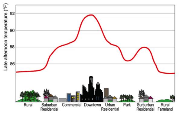
The urban heat island is real; cities are hotter than surrounding suburbs. That’s why climate records are maintained at sites well away from the asphalt and concrete of city cores.
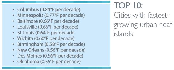
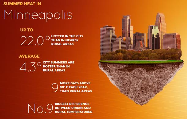
The planet is warming, but cities are heating up much faster. A new report from Climate Central finds that the Twin Cities metro has the 9th most intense summer urban heat island of America’s top 60 cities, with a daily average rural-urban temperature difference of 4.3F. Las Vegas is at the top of the list; The Strip a whopping 7.3F warmer than surrounding deserts.
80 percent of Americans live in cities and the urban heat island is heating up our metro areas much faster than rural areas. Details on the blog below.
Clouds kept us a bit cooler yesterday, but hazy sun should lure the mercury well into the 80s today and Saturday; low 90s possible Sunday with a debilitating dew point near 70F. Serious Dog Days.
I expect a dry sky at the State Fair today and much of tomorrow; a few storms rumble in late Saturday.
Mother Nature appears manic: a sizzling Sunday gives way to fresh air by midweek – lows near 50F by Thursday. Heat builds again late next week as 80s return.
Summer spills into September this year.
* Graphics above courtesy of Climate Central, which has the full PDF report here.
Hot And Getting Hotter: Heat Islands Cooking U.S. Cities. Climate Central highlights the large (and growing) difference in temperature between the downtown urban core, experiencing additional heating from asphalt and concrete surfaces, versus outlying suburbs. The differences on a sunny, summer day can be extraordinary, as much as 10-20F. or more. Here’s an excerpt: “…With more than 80 percent of Americans living in cities, these urban heat islands — combined with rising temperatures caused by increasing heat-trapping greenhouse gas emissions — can have serious health effects for hundreds of millions of people during the hottest months of the year. Heat is the No.1 weather-related killer in the U.S., and the hottest days, particularly days over 90°F, are associated with dangerous ozone pollution levels that can trigger asthma attacks, heart attacks, and other serious health impacts. Our analysis of summer temperatures in 60 of the largest U.S. cities found that: 57 cities had measurable urban heat island effects over the past 10 years. Single-day urban temperatures in some metro areas were as much as 27°F higher than the surrounding rural areas, and on average across all 60 cities, the maximum single-day temperature difference was 17.5°F...”
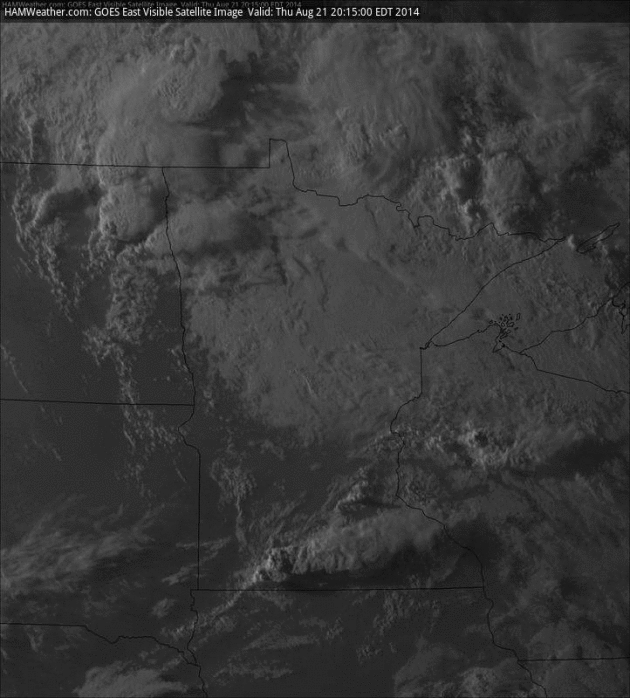
Saved By Stubborn Cumulus. A Heat Advisory was issued for a time yesterday from the southern suburbs into south central Minnesota as overheated air pushed into Minnesota. But lingering clouds kept temperatures cooler than they would have been had the sun stayed out for a few hours. There was enough instability for T-storms to bubble up; one sparked a possible tornado touchdown near Mountain Lake at 5:20 PM yesterday. Visible loop: HAMweather.
Drier Friday – Late Saturday Storm Risk. 4 KM NAM model data from NOAA shows the next wave of heavy T-storms rumbling across Minnesota late Saturday and Saturday night, but today should be partly sunny and dry with a light north/northeast breeze. Heat spikes Sunday (low 90s?) before a big cool-down early next week. 60-hour accumulated rain loop: HAMweather.
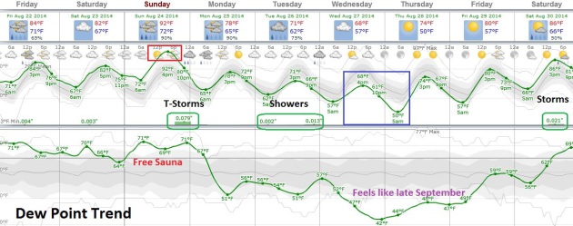
A Serious Case of the Stickies into Sunday. Long-range guidance shows a dew point in the upper 60s to near 70 today into Sunday, followed by a whiff of Canadian air much of next week as dew points tumble into the 40s and 50s. Storms are possible late Saturday, likely late Sunday as cooler air approaches; another round of showers Tuesday, especially southern Minnesota. We dry out Wednesday – Friday of next week as temperatures slowly warm up. I could see a few sweatshirts coming out up north by Thursday morning.
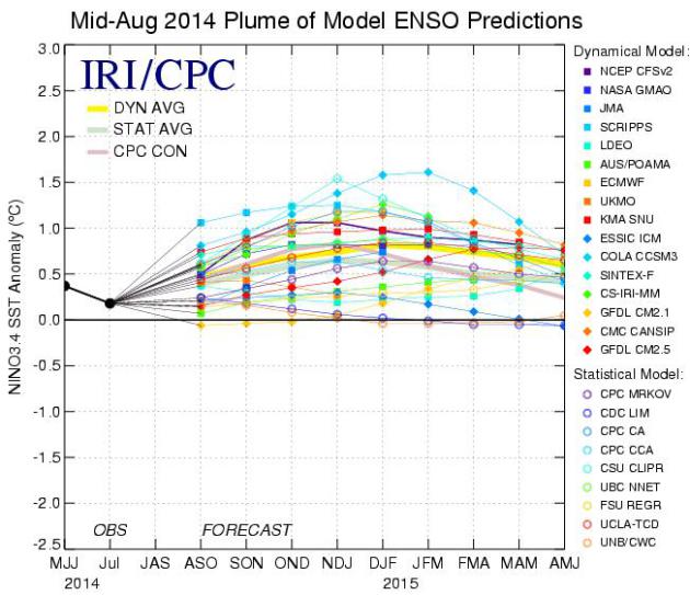
El Nino: Down, But Not Out. Here’s an excerpt of an in-depth look at ENSO and what will probably still be a mild to moderate El Nino event later in 2014 and early 2015, courtesy of International Research Institute for Climate and Society at Columbia University: “…Most of the set of dynamical and statistical model predictions issued during late July and early August 2014 predict a transition from neutral ENSO conditions to weak El Nino conditions during northern early fall 2014 with some further warming predicted into late fall and winter 2014-15. Development of El Nino conditions appears approximately 50% likely for the Aug-Oct or Sep-Nov seasons of 2014, and rises to 70-75% by Nov-Jan and Dec-Feb 2014-15…”
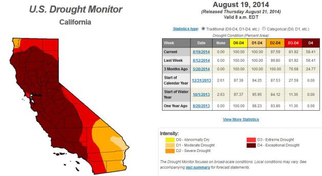
63 Trillion Gallons of Groundwater Lost in Drought, Study Finds. This story at The Los Angeles Times provides perspective, and a few staggering statistics; here’s a clip: “The ongoing drought in the western United States has caused so much loss of groundwater that the Earth, on average, has lifted up about 0.16 inches over the last 18 months, according to a new study. The situation was even worse in the snow-starved mountains of California, where the Earth rose up to 0.6 inches. Researchers from UC San Diego’s Scripps Institution of Oceanography and the U.S. Geological Survey estimated the groundwater loss from the start of 2013 to be 63 trillion gallons — the equivalent of flooding four inches of water across the United States west of the Rocky Mountains…” (Latest U.S. Drought Monitor data is here).
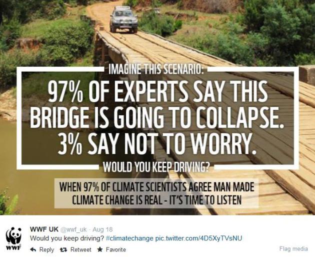
Hurricane Hype Is Here To Stay – Forecasters Must Adapt. Because now everyone is an armchair meteorologist, and can tweet information that is dubious or outright malicious. I echo many of meteorologist Jason Samenow’s concerns over at Capital Weather Gang; here’s an excerpt of what he had to say about recent hurricane-hype: “…Many weather communicators want the public to understand the full range of possibilities. We want the public to appreciate that model simulations for storms more than five days into the future aren’t realistic. We lament that armchair meteorologists (amateurs, students, novices, etc.) post unreliable model simulations on social media – without any context – of a storm obliterating a coastal city. We cringe when these suspect forecasts are shared thousands of times, misleading an unknowing public. While some us are secretly envious of the attention, we ultimately worry about a loss of public trust in weather forecasting when they are wrong (most of the time)…”
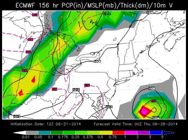
* ECMWF forecast valid next Wednesday evening courtesy of WSI. The European model hints at a close encounter for the Outer Banks of North Carolina, but keeps any tropical system offshore. We’ll see.
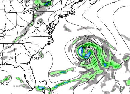
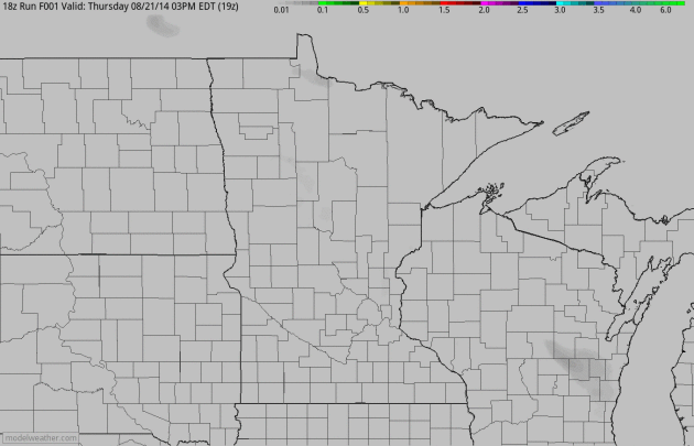
A Wildly Erratic GFS Solution. 3 days ago the GFS was hinting at a possible tropical landfall somewhere along the Gulf Coast near Louisiana. 2 days ago eastern Florida was in the crosshairs. Yesterday’s 18Z run (above) shows a possible hurricane bearing down on Bermuda. If the trends continue residents of Spain had better watch out. Translation: confidence levels are still VERY low, but the situation bears watching. Map: Weather Bell.
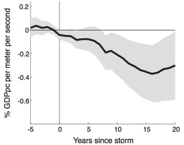
New Study Reveals The Lingering Economic Devastation Left by Hurricanes. The negative impact from hurricanes can linger not only years, but decades after a major strike. Here’s an excerpt of a story that caught my eye, courtesy of Business Insider Malaysia: “… A full fifteen years after a hurricane or typhoon strikes a country, that country’s per capita GDP will be lower by 0.38% for each meter per second of top wind speed than it would have been without the cyclone. So, a storm whose top wind speed was 10 m/s, or about 22 miles per hour, would have its per capita GDP lowered by about 3.8% fifteen years later, compared to a stormless baseline. The authors also note that cyclones have a much more severe effect on countries with multiple storms. Because each hurricane or typhoon negatively affects GDP in the long term, multiple storms over a period of time can have effects that add up…”
Graphic credit above: Hsiang and Jina, July 2014

Using GPS To Improve Tropical Cyclone Forecasts. Here’s an excerpt of a forecast from UCAR in Boulder, Colorado focusing on promising new technology that may be able to help pinpoint cyclone track and intensity: “One of the challenges in forecasting tropical cyclones is that measuring atmospheric conditions over the open ocean is extremely difficult. New research indicates that the COSMIC microsatellite system, which uses a technology known as GPS radio occultation to observe remote regions of the atmosphere, can significantly improve predictions of tropical cyclones. Forecasts traditionally draw on observations taken by instruments on Earth’s surface or by radiosondes, which are lifted into the atmosphere by balloons. But both these approaches are limited in hard-to-access places, like the open ocean. In contrast, GPS radio occultation measurements can be made almost anywhere, and they are unaffected by clouds, light rain, or airborne aerosols…”
Image credit above: “By using GPS signals to monitor the atmosphere in three dimensions, the FORMOSAT-3/COSMIC satellite constellation has led to improved global weather monitoring, especially in data-sparse regions.” (Image courtesy UCP/COSMIC).
How The “Year of Four Hurricanes” Changed Florida’s Readiness. New communications tools exist that weren’t around 10 years ago, but amazing platforms like cell phone texts, Twitter and Facebook can transmit not only essential, accurate information and warnings, but also rumor, inuendo and misinformation. Here’s an excerpt of what’s changed (for the better) from Emergency Management: “…Communications: When the 2004 storms struck, Twitter did not exist. Neither did the iPhone. A new website called TheFacebook had just been created in a Harvard dorm room. When it came to hurricanes, the latest news arrived via television, the Web and radio. Today, when a storm gets close, text alerts will go out to anyone within range of South Florida cellphone antennas, even if their phone has a Cleveland or New York City area code. Emergency managers also plan to rely heavily on social media to get the word out. At the Broward County Emergency Operations Center, about 40 volunteers have been trained to monitor Facebook and Twitter for information on people trapped, in need of food or dealing with other emergency situations, said emergency manager Miguel Ascarrunz…”
Photo credit above: “Charley was the first of four hurricanes to strike Florida in 2004.” (Andrea Booher/FEMA).

Twins: A Gold Mine for Research. I married a twin. And no, I don’t get them confused. That could be fatal. Here’s an excerpt of a fascinating tale from The Atlantic: “This is one party where virtually no one shows up alone. Two thousand sets of twins packed into the small city of Twinsburg, Ohio earlier this month to celebrate their twin-ness at a three-day festival called Twins Days. Throughout the weekend, twins marched in the “Double Take” parade, competed in look-alike contests, and snapped photos with one another at a welcome wiener roast on Friday night. Though the festival is meant for twins, there is another group that is just as eager to attend this annual celebration of shared genetics—scientists…”
Photo credit above: “Each year, thousands of attendees dress alike for Twins Days. These twins were taking a dip in the pool at the Bertram Inn and Conference Center in Aurora, Ohio on the first day of the festival.” (Charles Robinson).

Ripening Leaves? Media Logic Group meteorologist Susie Martin snapped this photo of a sugar maple leaf in Eden Prairie. The leaves are leaving…in late August? It’s way too early for that.

TODAY: Partly sunny, sticky and dry. Dew point: 67. Winds: NE 5. High: 85
FRIDAY NIGHT: Warm and sultry. Low: 71
SATURDAY: Murky sun, T-storms rumble in late. Dew point: 70. High: 86
SUNDAY: Stinking hot. Hot sun much of the day. Late day storm risk. Wake-up: 74. High: 91 (Heat Index near 100 by late afternoon?)
MONDAY: Blue sky, less humid. Dew point: 56. Wake-up: 67. High: 80
TUESDAY: Clouds, few showers likely. Wake-up: 63. High: 74
WEDNESDAY: Some sun, fresh air! Dew point: 49. Wake-up: 57. High: 72
THURSDAY: Bright sun, spectacular. Dew point: 47. Wake-up: 52. High: 76
Climate Stories…

Jet Stream Changes Driving Extreme Weather Linked Again to Global Warming, Arctic Ice Loss. Here’s a story, video and links to research from ThinkProgress; an excerpt:
Weather extremes in the summer — such as the record heat wave in the United States that hit corn farmers and worsened wildfires in 2012 — have reached an exceptional number in the last ten years. Man-made global warming can explain a gradual increase in periods of severe heat, but the observed change in the magnitude and duration of some events is not so easily explained. It has been linked to a recently discovered mechanism: the trapping of giant waves in the atmosphere. A new data analysis now shows that such wave-trapping events are indeed on the rise.
A number of studies in recent years have linked this quantum jump in extreme weather to global warming and the warming-driven loss of Arctic ice (see here and here). Jennifer Francis of Rutgers University’s Institute of Marine and Coastal Sciences has been at the forefront of this research. She explains her findings in this video…”
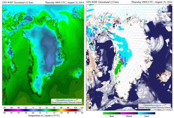
Greenland’s Late August Rain Over Melt Ponds Is A Glacial Outburst Flood Hazard. Robert Scribbler has an interesting post; here’s an excerpt: “Glacial melt ponding on steep ice faces. Above freezing temperatures for an extended period. Storms delivering rainfall to the glacier surface. These three events are a bad combination and one that, until recently, we’ve never seen before for Greenland. It is a set of circumstances directly arising from a human-driven warming of the great ice sheet. And it is one that risks a highly violent and energetic event in which melt ponds over-top and glaciers are flushed and ripped apart by surges of water rushing for scores of miles over and through the ice sheet...”
Map credit above: “GFS temperature and rainfall analysis for Greenland on August 21, 2014. Note the above freezing temperatures and rainfall over the region of the Jacobshavn Glacier for today.” Image source: University of Maine’s Climate Reanalyzer.

Climate Change Scientists Call On Colleagues To Speak Up On Global Warming Debate. Here’s a video and excerpt of a story at The Sydney Morning Herald: “…One of Australia’s most senior climate scientists has called on his colleagues not to sit on the sidelines of the political debate about global warming and other environmental issues, given the evidence they present asks society to consider fundamental changes. In a speech to be given to the Australian Academy of Science on Tuesday evening, Dr Michael Raupach will say environment scientists’ position in the public debate had changed because they were now presenting evidence requiring society to make major choices in response…”
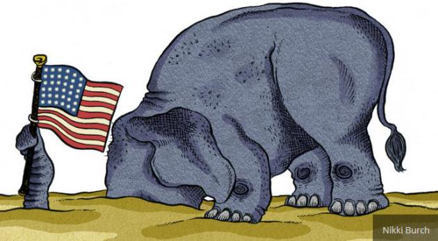
Meet The Climate Deniers Who Want to be President. What has happened to the Republican Party? You can’t be pro-free markets and strong on defense, and still acknowledge basic science, at least when it comes to climate change? At some point I hope cooler (smarter) heads prevail. Younger voters are taking this subject very seriously and will vote accordingly. Here’s an excerpt from a story by Ben Adler at Grist: “…The Republicans basically fall into four categories: (1) Flat-Earthers, who deny the existence of manmade climate change; (2) Born-Again Flat-Earthers, who do the same, but who had admitted climate change exists back before President Obama took office; (3) Do-Nothings, who sort of admit the reality of climate change but oppose actually taking any steps to prevent it; and (4) Dodgers, who have avoided saying whether they believe climate change is happening, and who also don’t want to take any steps to alleviate it. Louisiana Gov. Bobby Jindal and Wisconsin Gov. Scott Walker fall into the latter category. The Do-Nothings are blue and purple state governors, Chris Christie of New Jersey and John Kasich of Ohio...”

Late-Night TV’s Top 5 Moments in Denial-Busting. Forecast The Facts has links to some of the more memorable climate denier-debunking’s; here’s an excerpt and link to the videos: “Jon Stewart just delivered an epic takedown of climate change deniers, but that was hardly the first time late night TV has taken them on. Check out the top five moments in climate denial busting below — and share widely!“
