The Tale Of Two Novembers
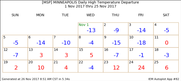
November has been quite an interesting month so far in the Twin Cities, split between cold and warm. Highs during the first week and a half of the month were up to 18 degrees below average. By the middle of the month, we started to see a turn around, with warmer weather returning to the region. We saw our first 50 (and 60) degree day of the month Friday, as highs climbed to 24 degrees above average.
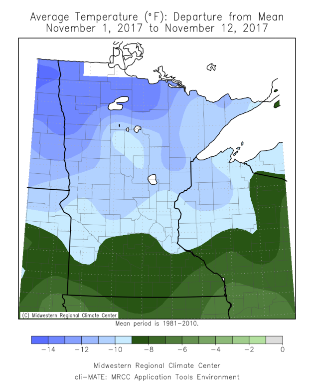
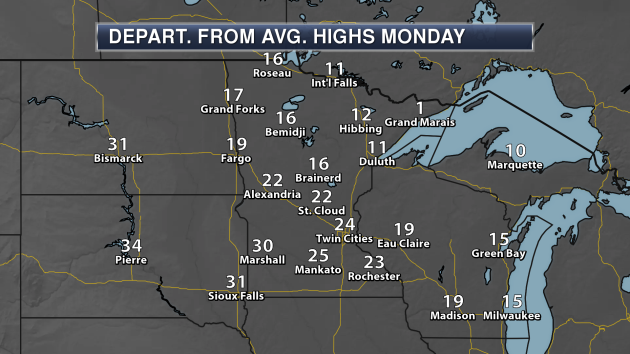
This was what the departure from average map looked like across the state for the first twelve days of the month. Many areas across central and northern Minnesota had been over 10 degrees below average for the first twelve days of the month.
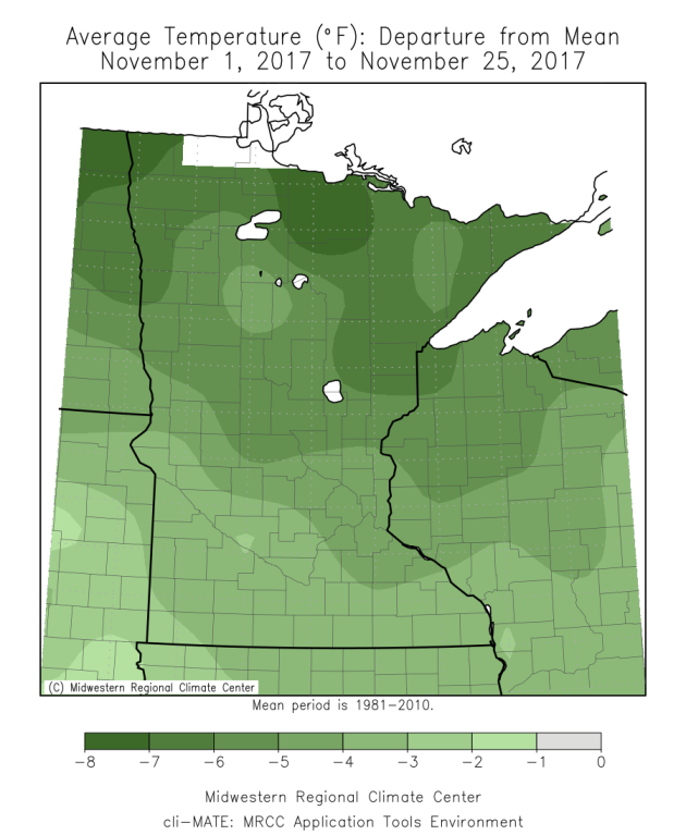
These warmer temperatures during the second half of the month have helped our average temperature rebound from where they were earlier this month – although we are still below average (by 2.3 degrees in the Twin Cities through Saturday and 5.5 degrees in International Falls) so far with a few more days to go.
_______________________________________________
Warm End To November – Highs In The 50s Monday
By D.J. Kayser, filling in for Paul Douglas
Have you been enjoying our upside down November temperatures this month?
In the Twin Cities, we go from an average high of 50 on November 1st down to 33 by the 30th. This November, though, we’ve essentially done the opposite. The month started off on a cold note, with below average temperatures each of the first 12 days. The coldest day came on the 10th, with a high of 26 and a low of 11. Since then we’ve turned a corner, with mainly above average temperatures since the 12th and even a record-breaking 60 degree high on Black Friday.
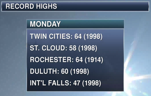
We’ll continue to see warmer than average weather through the end of November across the region. Highs today will reach the upper 50s in the Twin Cities, likely falling short of the 64 degree record set back in 1998. However, mid 60s can be expected as close as southwestern Minnesota later today! Warm weather will continue into December as well, with highs in the 40s into next weekend.
Make the most of this warm weather while it lasts – the other shoe has to drop at some point, right?
_______________________________________________
Extended Twin Cities Forecast
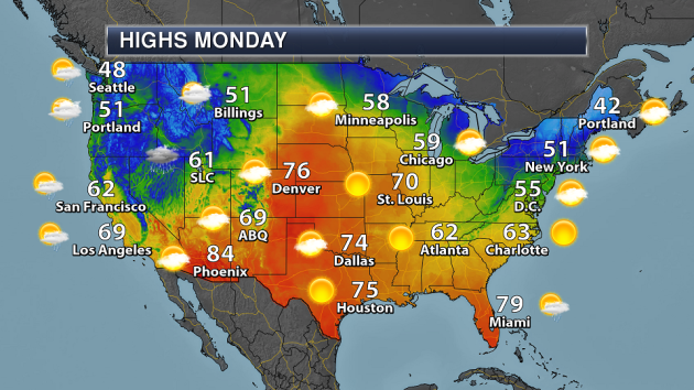
MONDAY: Warm late November sun. High 58. Low 38. Chance of precipitation 0%. Wind SSE 5-15 mph.
TUESDAY: Decreasing clouds. Breezy winds. High 47. Low 29. Chance of precipitation 0%. Wind WNW 10-15 mph.
WEDNESDAY: Sunny start. Clouds on the increase. High 46. Low 32. Chance of precipitation 10%. Wind S 5-10 mph.
THURSDAY: Early shower/snowflake? Turning sunny. High 40. Low 27. Chance of precipitation 10%. Wind NW 10-15 mph.
FRIDAY: Nice start to December. High 43. Low 29. Chance of precipitation 0%. Wind SW 5-10 mph.
SATURDAY: Highs stay above average. High 42. Low 32. Chance of precipitation 0%. Wind S 5-10 mph.
SUNDAY: A few late day showers. High 43. Low 31. Chance of precipitation 30%. Wind SW 5-10 mph.
_______________________________________________
This Day in Weather History
November 27th
2005: In the early morning a home in Mower County is hit by lightning and burned to the ground, but no one is injured.
1994: A low pressure system produces the first winter storm of the season for Minnesota. By the early morning hours of the 28th, a swath of snow in excess of 6 inches had blanketed much of southwest through central into northeast Minnesota. Snowfall of 6 inches or more occurred south of a line from Gunflint Lake in Cook County to near Ortonville in Big Stone County, and along and north of a line from near Blue Earth in Faribault County to Red Wing in Goodhue County. The snow closed the Minneapolis-St. Paul International Airport for a short time on the 27th, and contributed to hundreds of accidents and at least three fatalities. In addition, the build-up of ice and snow in combination with strong winds resulted in numerous downed power lines in southeast Minnesota.
1985: Extreme cold hits northern Minnesota. A low of 30 below zero is reported at Crookston.
1971: Heavy snow falls in southwest Minnesota, with Redwood Falls receiving a foot.
_______________________________________________
Average Temperatures & Precipitation for Minneapolis
November 27th
Average High: 34F (Record: 64F set in 1998)
Average Low: 20F (Record: -13F set in 1872)
Average Precipitation: 0.05″ (Record: 0.90″ set in 1905)
Average Snow: 0.4″ (Record: 4.9″ set in 1983)
________________________________________________
Sunrise/Sunset Times for Minneapolis
November 27th
Sunrise: 7:26 AM
Sunset: 4:34 PM
*Length Of Day: 9 hours, 8 minutes and 8 seconds
*Daylight Lost Since Yesterday: ~1 minute and 46 seconds
*Latest Sunrise At/After 7:30 AM: November 30th (7:30 AM)
*Earliest Sunset: December 5th-13th (4:31 PM)
________________________________________________
Minnesota Weather Outlook
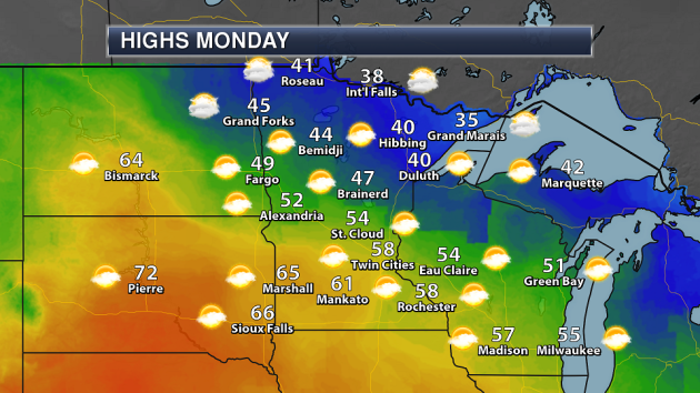
Another warm day is expected Monday, with highs reaching into the 50s and 60s across southern Minnesota under a mix of clouds and sun. Take a look out toward Pierre – highs in the 70s! Cool weather will continue to hang on across northern Minnesota, with highs in the 30s and 40s.
While highs Monday will approach records across southern Minnesota, they will likely fall short by about 5 degrees. The record to break in the Twin Cities is 64, set back in 1998.
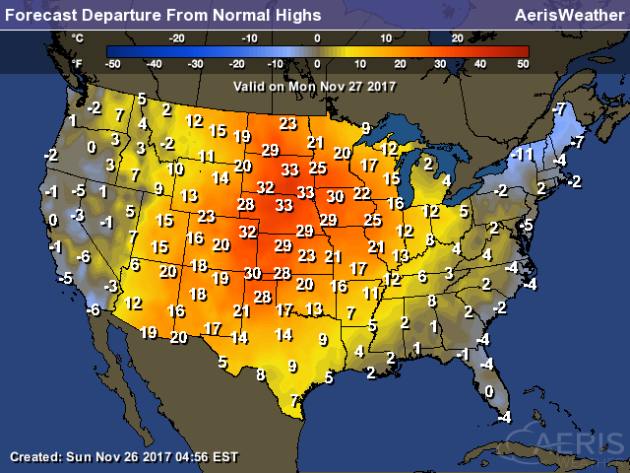
While records look to be out of reach at the moment, these highs will be far above average across most of the state. We could even see highs that are 30 degrees above average across parts of southwestern Minnesota.
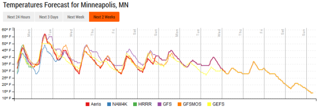
Monday looks to be the warmest day of the next couple weeks, however that doesn’t exactly mean that we will dramatically cool down. Highs will likely remain in the 40s for the rest of the week and into the weekend in the Twin Cities, which is still 5-10 degrees above average.
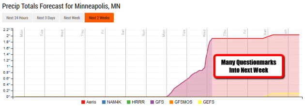
Precipitation chances look very slim this week in the Twin Cities. While we may wake up to a few raindrops or snowflakes Thursday morning, the next rain chance won’t move in until late next Sunday – and even then, there is model disagreement. Where there is major model disagreement is during the first full week of December, with differences not only between the GFS and European, but also run-to-run of each individual model. So after a calm week expected this week… we’ll have to see if the weather does become more active into the first full week of December.
________________________________________________
National Forecast
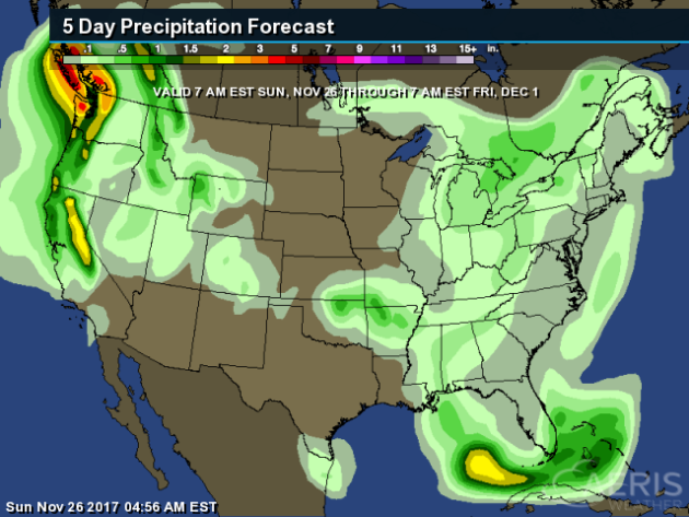
A clipper system will continue to bring some snow to northern New England on Monday. Precipitation will be possible across the western United States in the form of rain and snow along a frontal boundary from North Dakota to southern California. Some precipitation will also be possible in the Pacific Northwest, ahead of a frontal system moving in on Tuesday. The big story, however, will be the heat across the central U.S.
Highs across the central United States will be quite warm for the end of November, with parts of the Plains seeing highs that are 30+ degrees above average! The cooler weather will be found at the coasts, with parts of northern New England 5-15 degrees below average.
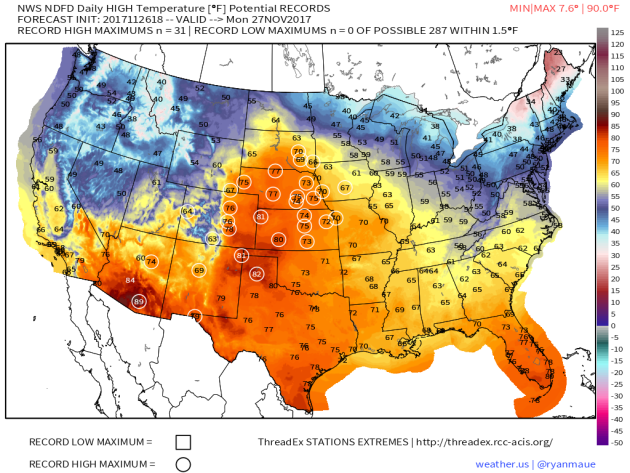
With temperatures that will be 20-30+ degrees above average Monday in the central United States, at least 31 record highs will be possible in the lower 48.
The heaviest precipitation from Sunday through the end of the month is expected in parts of the western U.S., where liquid precipitation amounts could top 2″ in spots.
________________________________________________
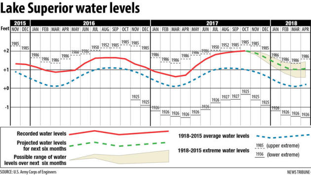
Lake Superior To Reach Record Levels?
Lake Superior has been sitting high the past few months, and the U.S. Army Corps of Engineers says that the lake could reach record levels next year depending on how much rain and snow falls the next few months.
More from the Duluth News Tribune: “
The current forecast by the Corps of Engineers is for the lake to remain above normal well into 2018. After that, it’s in the hands of Mother Nature. Lake Superior now sits a foot above normal and 7 inches above last November’s level. It’s still 5 inches below its record for November, but the all-time record high, if it comes, will be sometime next August, September or October when the lake reaches it seasonal peak. (The lake usually reaches its low point in April, then rises with spring snowmelt and rain until August, before beginning its seasonal decline.)” (Image: Duluth News Tribune)
Rising Snow Lines Out West
A new study shows that the snow line in the Sierra Nevada has been moving uphill over the past several years – fairly quickly.
More from KQED: “
Researchers have been keeping their eyes on the “snow line,” the point of elevation where rain turns to snow (or vice versa) during winter storms in the northern Sierra. What they found is that warming temperatures have pushed that level uphill by 1,200-to-1,500 feet in recent years. If that sounds like a lot, even the lead author of the study was surprised when the data came in.“
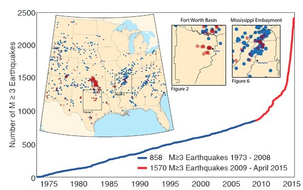
Texas Earthquakes Due To Drilling
Increased earthquake activity in Texas can just about be completely contributed to recent drilling as these faults have otherwise been dormant for 300 million years, according to a new study. More from Scientific American: “Since 2008, Texas, Oklahoma, Kansas and a handful of other states have experienced unprecedented surges of earthquakes. Oklahoma’s rate increased from one or two per year to more than 800. Texas has seen a sixfold spike. Most have been small, but Oklahoma has seen several damaging quakes stronger than magnitude 5. While most scientists agree that the surge has been triggered by the injection of wastewater from oil and gas production into deep wells, some have suggested these quakes are natural, arising from faults in the crust that move on their own every so often. Now researchers have traced 450 million years of fault history in the Dallas-Fort Worth area and learned these faults almost never move. “There hasn’t been activity along these faults for 300 million years,” says Beatrice Magnani, a seismologist at Southern Methodist University in Dallas and lead author of a paper describing the research, published today in Science Advances. “Geologically, we usually define these faults as dead.”” (Image: Quakes have been common in Texas and Mississippi since 2008. But Texas jolts are on faults that had been silent for millions of years, unlike Mississippi, indicating recent human activity set them loose. Credit: Magnani et al., Sci. Adv. 2017;3: e1701593)
______________________________________________