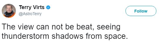
Thunderstorm Shadows From Space
Well, this is kind of neat. This Tweet from @AstroTerry aboard the ISS shows shadows from thunderstorms!! See more from @AstroTerry HERE:

_____________________________________________________________________________


________________________________________________________
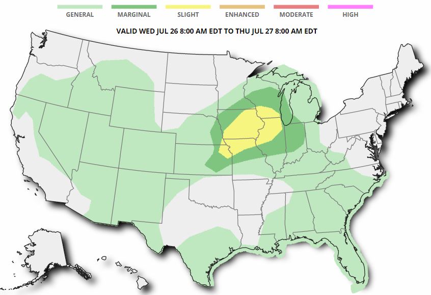
Severe Threats: Wednesday
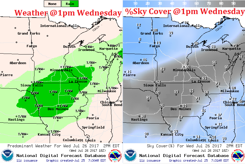
According to NOAA’s SPC, there is a risk of strong to severe storms on Wednesday across the southern half of the state and into Wisconsin. Note that the best chance will be found extreme southeastern Minnesota, including Albert Lee, Owatana and Rochester.
.png)
Simulated Radar
.gif)
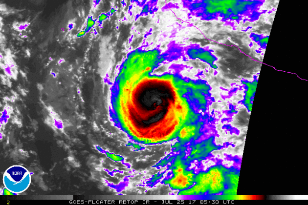
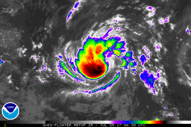
Tracking HILARY
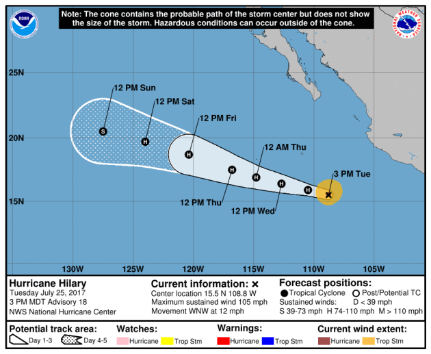
HILARY Strength
.png)
.png)
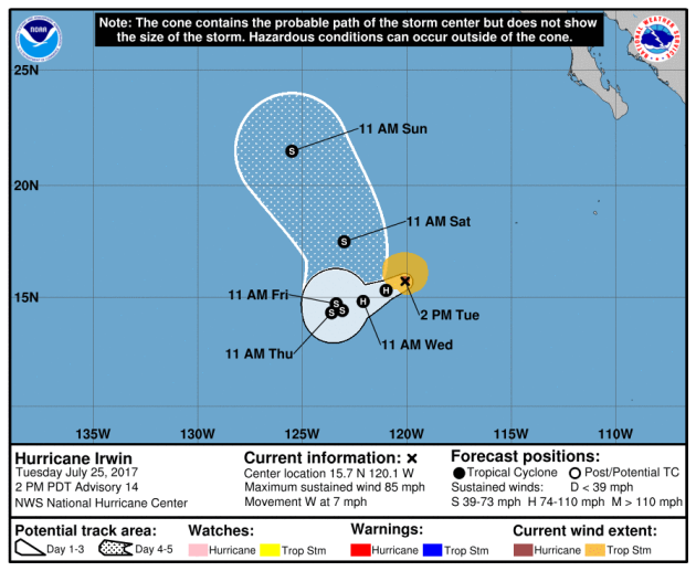
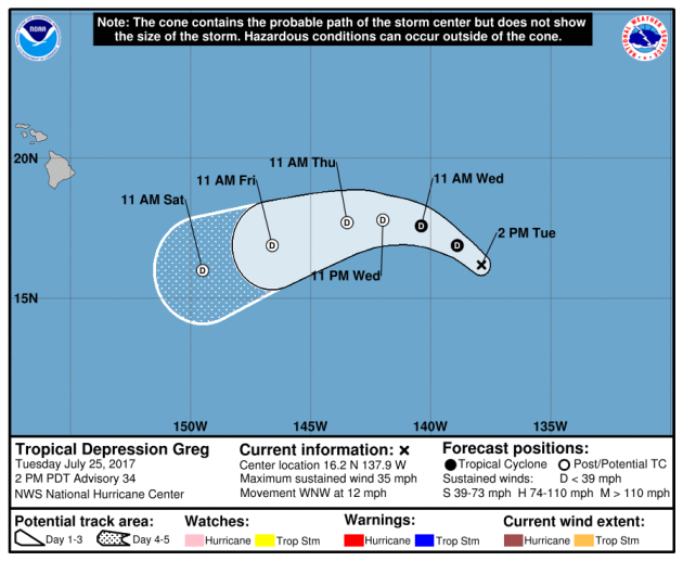
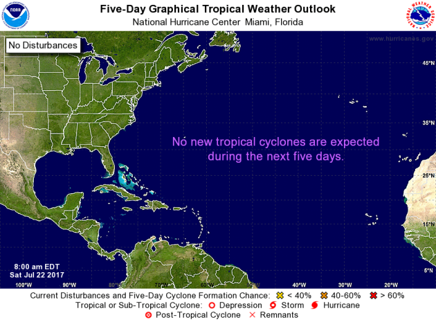
Meanwhile, the Atlantic basin looks to remain quiet over the next 5 days. Stay tuned…
 __________________________________________________________________________
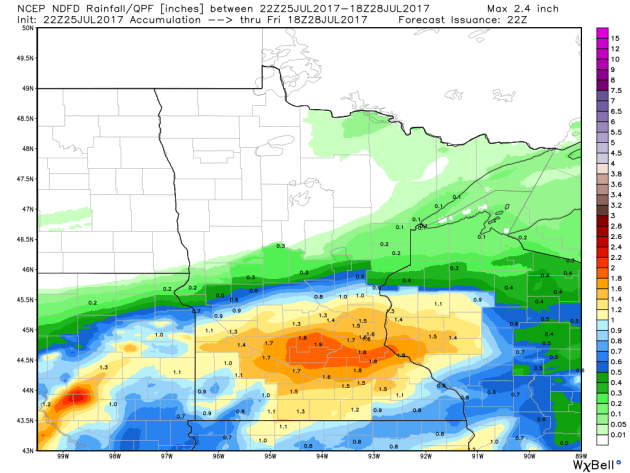
It certainly has been a fairly active first half of 2017 with 1190 preliminary tornado reports through July 23rd. Note that this is the most tornadoes through July 23rd since 2011, when there were 1,662 reports. The map below shows the distribution of the tornadoes so far this year.
.gif)
PRELIMINARY 2017 Tornado Count
According to NOAA’s SPC, the PRELIMINARY 2017 tornado count is 1192 (through July 24). Note that is the most active year for tornadoes since 2011, when there were 1,664 tornadoes. Keep in mind there was a major tornado outbreak in the Gulf Coast region from April 25-28, 2011 that spawned nearly 500 tornadoes, some of which were deadly. That outbreak is known as the Super Outbreak of 2011 and has gone down in history as one of the biggest, costliest and one of the deadliest tornado outbreaks in history.
.png)
____________________________________________________________
National Weather Hazards Ahead…
1.) Heavy rain across portions of the Mid-Atlantic and the Northeast, Fri, Jul 28.
2.) Heavy rain across portions of the Southeast and the Mid-Atlantic, Sat-Mon, Jul 29-Jul 31.
3.) Heavy rain across portions of the Central and Southern Rockies and the Central and Southern Plains, Sun-Mon, Jul 30-Jul 31.
4.) Flooding occurring or imminent across portions of the Upper and Middle Mississippi Valley and the Great Lakes.
5.) Flooding likely across portions of the Middle Mississippi Valley.
6.) Flooding possible across portions of the Central and Southern Plains, the Central and Southern Rockies, the Central Great Basin, and the Southwest.
7.) Moderate risk of much above-normal temperatures for portions of the Central Valley of California, Wed-Thu, Aug 2-Aug 3.
8.) Slight risk of much above-normal temperatures for portions of the Great Basin, the Northern Plains, the Northern Rockies, California, the Pacific Northwest, and the Southwest, Wed-Sun, Aug 2-Aug 6.
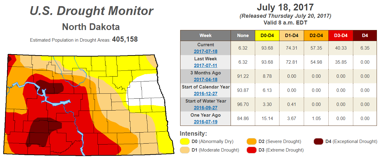
9.) Severe Drought across parts of the Great Plains, Arizona, California, and Hawaii.
.png)
_________________________________________________________“Exceptional drought in Northern Plains in July 2017”
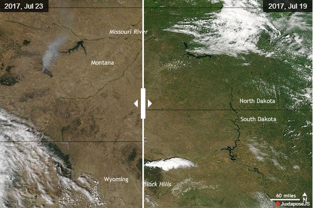
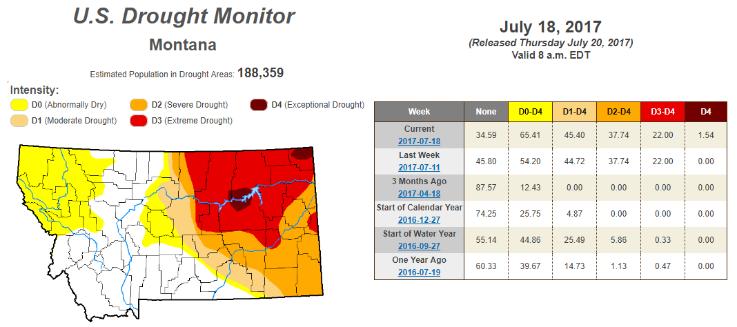
“The Northern Plains were in the midst of a punishing drought in July 2017. Along with a lack of rainfall, the weekly average temperature was more than 90°F for a swath of the region from Montana southward to Kansas, which further accelerated the development of extreme to exception drought in parts of Montana and North and South Dakota. According to the July 18 report from the U.S. Drought Monitor project, 22% of Montana was in severe or exceptional drought. Across an additional 23% of the state, drought conditions were ranked as moderate to severe. In North Dakota, more than 70 percent of the state was in some level of drought, with 40% of that being extreme or exceptional.”
See more from Climate.gov HERE:
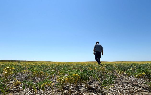
_______________________________________________________________“Hi-Line farmers feeling drought’s burn”
“The life had been fading from Grant Zerbe’s stunted chickpeas for the better part of a month, and now drought’s hot breath was burning through the final green inch of every plant stem.The Montana farmer’s worst growing season in 30 years was coming to a brutal end. There are few crops to harvest in the region, and with a lack of food and water, unwanted livestock are headed to auction. “Normally, we’d be getting 1,200 pounds to an acre,” Zerbe said. “The crop would be so thick you couldn’t see the ground.” Northeast Montana is experiencing the worst drought in the country. On U.S. Drought Monitor maps, the Montana portion branded “extreme” spans 350 miles. Combined with drought in the Dakotas, Montana’s losses contribute to what the U.S. Department of Agriculture expects to be a 64 million bushel loss in wheat production. Durum, a specialty crop for Montana and North Dakota, is expected to be down in bushels 45 percent from last year.”
See more from BillingsGazette HERE:
(Frazer area farmer Grant Zerbe checks a chickpea crop as a drought grips eastern Montana. LARRY MAYER, Gazette Staff)
_________________________________________________________________
EXCEPTIONAL Drought in Montana
According to the US Drought Monitor, parts of Montana are now under an EXCEPTIONAL Drought. While nearly 2% is considered to be in an EXCEPTIONAL drought, 22% is under an EXTREME drought. Also, nearly 65% of the state is considered to be either abnormally dry or in some type of drought.
EXCEPTIONAL Drought in North Dakota
_________________________________________________________________________
National Weather Outlook
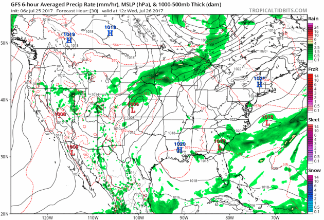
Here’s the weather outlook through the weekend suggests that stormy weather continuing in the Midwest with strong to severe storms and locally heavy rainfall through midweek. The storms will then move into the eastern part of the country with strong to severe storms possible Thursday and Friday with areas of locally heavy rain. Monsoon storms continue in the Southwest with a few strong storms and areas of locally heavy rain.
Excessive Rainfall Potential Wednesday & Thursday
.gif)
.gif)
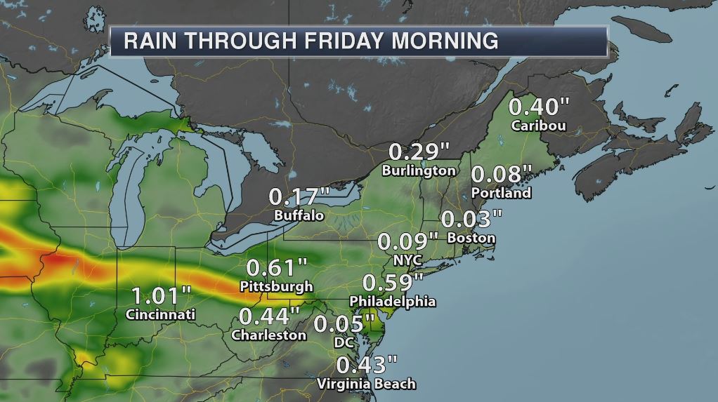
Excessive rainfall potential is possible across parts of the Midwest and the Northeast over the next couple days. The rainfall forecast suggests some 1″ to 2″+ rainfall tallies through AM Friday, which could lead to areas of localized flooding.
________________________________________________________
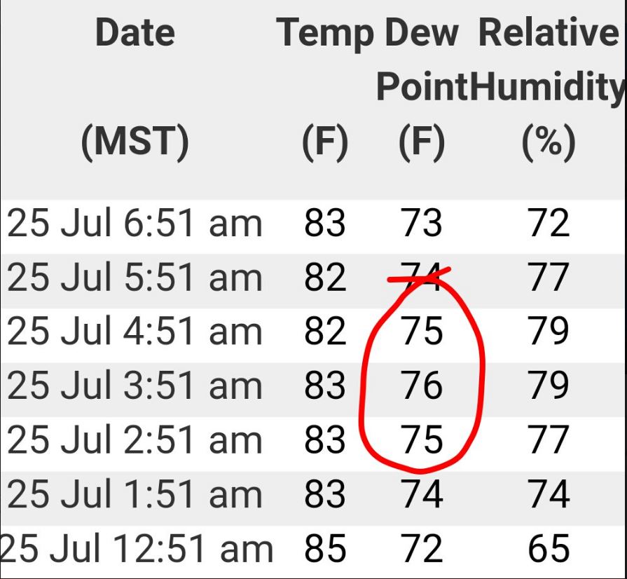
High Dewpoints in Phoenix, AZ
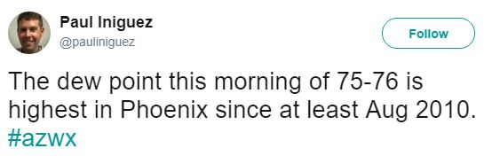
Thank to my good friend @pauliniguez for sharing this on Twitter, where dewpoints in Phoenix, AZ on Tuesday morning were in the mid 70s! Yea – that’s tropical!! In fact, this was the highest the dewpoint has been in the area since at leat August 2010! This high moisture content can be attributed to the ongoing monsoon season in the Desert Southwest.
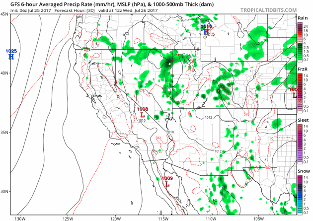
Monsoon Storms Continue
Here’s the simulated radar from Wednesday to Sunday, which shows the potential of daily monsoon storms continuing across the region. Note that some of the storms could be a little on the strong side with gusty winds, dust storms and locally heavy rain, which could lead to localized flooding. The rainfall forecast below suggests that some areas could see up to 1″ of rain or more through the end of the week!
 ________________________________________________________________________
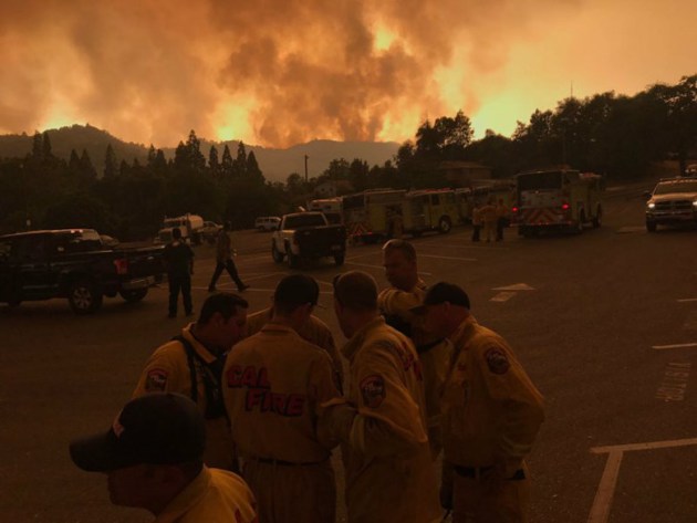
“Detwiler Fire morning update: 78,900 acres, 65% contained”
“The Detwiler Fire held at 78,900 acres and was 65 percent contained Tuesday morning, Cal Fire said. The acreage was unchanged from Cal Fire’s Monday night update on the Mariposa County blaze, but containment increased by 5 percent. A spike in activity Monday afternoon was reported on the northern end of the flames, near Dogtown east of Coulterville, which forced cancellation of a community meeting scheduled in Greeley Hill. Current Situation: Additional evacuations have been lifted in South County Mariposa with repopulation efforts continuing. Fire has sloped over division HH, but remains within secondary lines. Fire spread will continue to impact structures, transportation routes and infrastructure in these areas.”
See more from Fresno Bee HERE:
Image Credit: Al Golub Submitted photo via FresnoBee)
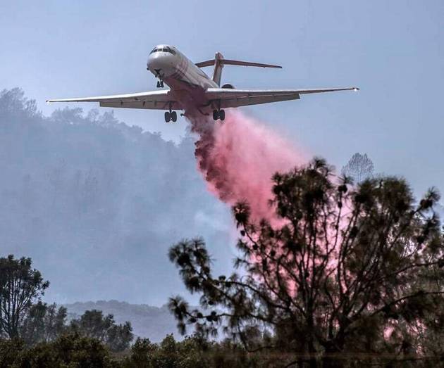
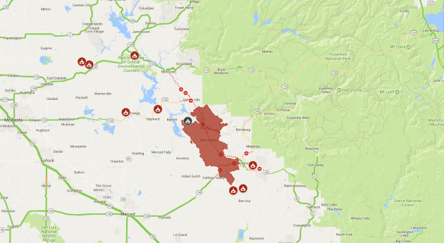
DetWiler Fire – Near Yosemite – California
The Detwiler Fire located near Yosemite National Park in California has ballooned to a very large 78,900 acre fire since Sunday, July 16th. This fire has already consumed more than 130 structures; 63 homes, 67 minor structures and 1 commercial structure. A number of other homes and smaller structures have been damaged as well, but 1,500 other structures are being threatened now. There are almost 5,128 people working on the fire and it is only 65% contained at this point . Higher humidity levels are helping create better fire fighting conditions.
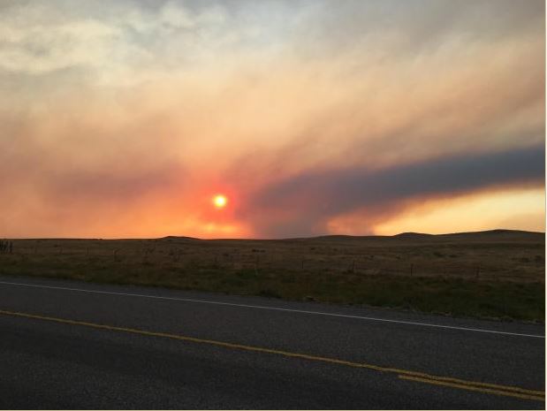
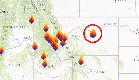
According to Inciweb, one of the largest fires currently burning in the Lower 48 is the Lodgepole Complex located 52 miles NW of Jordan, MT. This particular fire has consumed a whopping 250,000 acres and is expected to be fully contained by Wednesday, August 2nd. This particular fire started on Wednesday, July 19th and quickly spread as hot, dry and windy weather created extreme fire behavior. Gusty winds are still posing a concern for the fire.
(Image credit: By Chris Barth BLM)
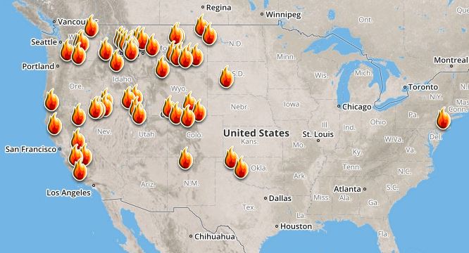
Here’s a look at the current wildfire map across the country. Recent hot and dry weather has helped to spark several wildfires across the Western US, while a few have also been popping up in the Eastern US.
Here’s a list of all the current large wildfires from Inciweb:
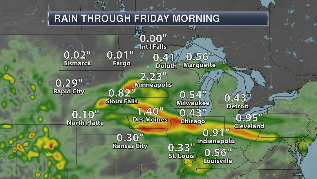
By Todd Nelson, filling in for DouglasLast week the US Drought Monitor declared parts of Montana and North Dakota in an exceptional drought. This is the first time some of these areas have been this dry in more than a decade.
The flash-drought has farmers reeling. A large majority of the spring wheat crop in Montana, North & South Dakota is considered to be in poor to very poor condition. Meanwhile, rounds of heavy rain have been impacting parts of Minnesota and the Midwest with as much as 4 to nearly 7 inches of rain since July 1st.
Another round of heavy rain across the southern half of the state will continue to linger through the first half of the day today. I am intrigued by the stretch of pleasant weather that looks to be settling in over the next several days as a bubble of high pressure slowly drifts over the region.
Mostly sunny, dry and comfortable weather will be in place through the end of the week and early weekend. Great timing for Billy Joel and FGL as they rock Target Field this weekend!
We’re all in the mood for a melody, Piano Man!
________________________________________________________________________
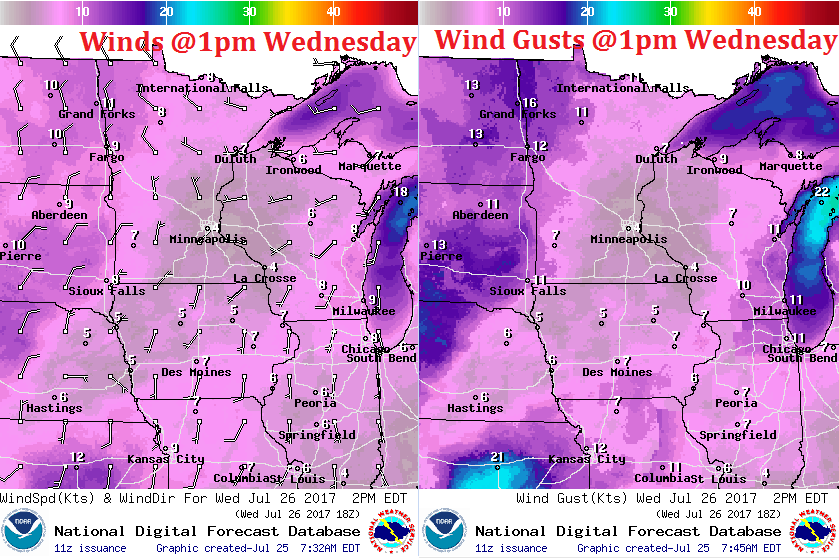
WEDNESDAY: AM storm. PM clearing. Winds: NNE 5. High: 83
WEDNESDAY NIGHT: Lingering storm over southern MN early, then clearing. Winds: NNW 5. Low: 64
THURSDAY: Few clouds. Feeling better. Winds: NNE 5-10. High: 82
FRIDAY: WOW! Almost perfect for late July. Winds: ESE 5. Wake-up: 62. High: 82
SATURDAY: Another beauty. Mild temps. Winds: SSW 5. Wake-up: 63. High: 83.
SUNDAY: Sunny start. Afternoon rumbles. Winds: WNW 5. Wake-up: 64. High: 83
MONDAY: Sun and cloud mix. Few showers? Winds: ESE 5. Wake-up: 65. High: 83.
TUESDAY: Increasing t-storm chances. Winds: SSE 5-10. Wake-up: 66. High: 81.
_______________________________________________________
This Day in Weather History
July 26th
1981: A chilly morning occurs across the Northland, with 33 degrees at Roseau and Wannaska.
________________________________________________________
Average High/Low for Minneapolis
July 26th
Average High: 83F (Record: 100F set in 1955)
Average Low: 64F (Record: 45F set in 1962)
Record Rainfall: 2.44″ set in 1990
_________________________________________________________
Sunrise/Sunset Times for Minneapolis
July 26th
Sunrise: 5:52am
Sunset: 8:46pm
Hours of Daylight: 14hours & 54mins
Daylight LOST since yesterday: ~2 minutes and 10 seconds
Daylight LOST since summer solstice (June 20th): ~43 minutes
__________________________________________________________
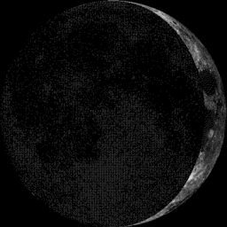
Moon Phase for July 26th at Midnight
3.3 Days Before First Quarter Moon
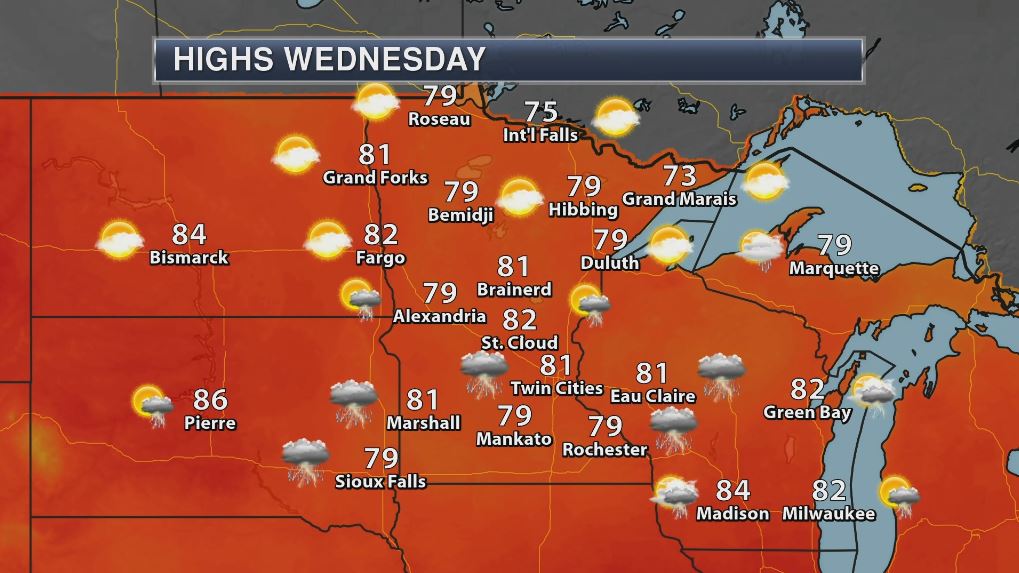
Highs on Wednesday won’t be quite as high as they were on Tuesday, but it’ll still be quite humid and a little on the unsettled side across the southern part of the state. However, cooler and less humid weather will be found across the northern half of the state and that’s the weather that most of us will be enjoying Thursday and Friday!
Weather Outlook For Wednesday
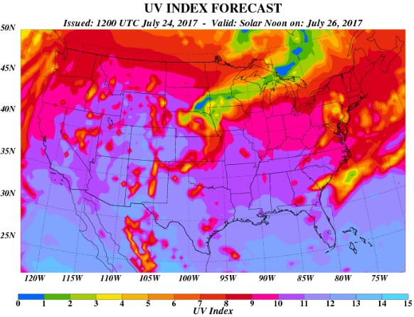
UV Index for Wednesday – HIGH
Despite there being more clouds across the southern half of the state, the UV Index will still be considered HIGH to VERY HIGH across central and northern Minnesota when the sun pops out on Wednesday. That means that it will only 15 to 25 minutes or less to burn unprotected skin. With that said, if you are planning on spending any extended length of time outside, make sure you wear appropriate attire and lather on the sun block!
 __________________________________________________________________________
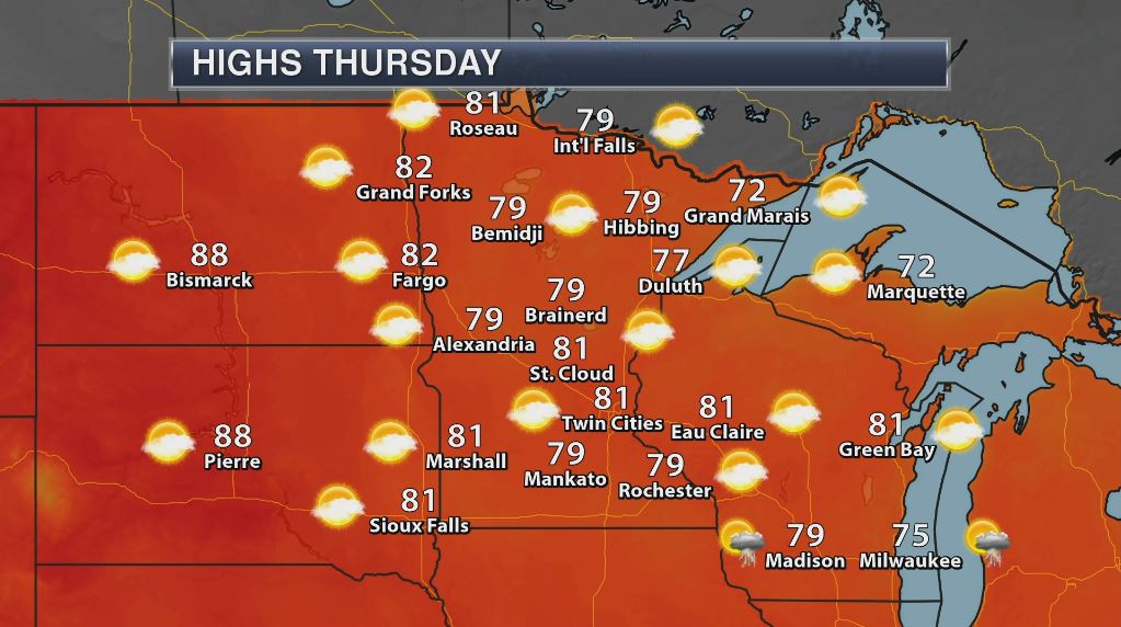
Weather Outlook For Thursday
Thursday looks like a very nice day across the region with comfortable temperatures and lower dewpoints values. There also appears to be plenty of sunshine building into the region through the end of the week and even into Saturday. Enjoy!
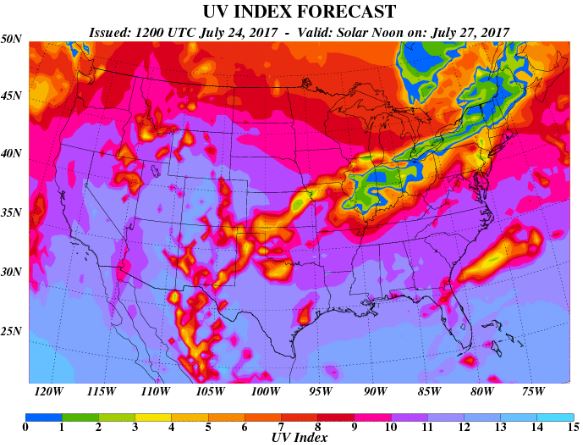
UV Index for Thursday – VERY HIGH
Mostly sunny skies on Thursday will bring UV Index values into the VERY HIGH range once again. That means that your skin could burn in 15 to 20 minutes or less!
 _____________________________________________________________
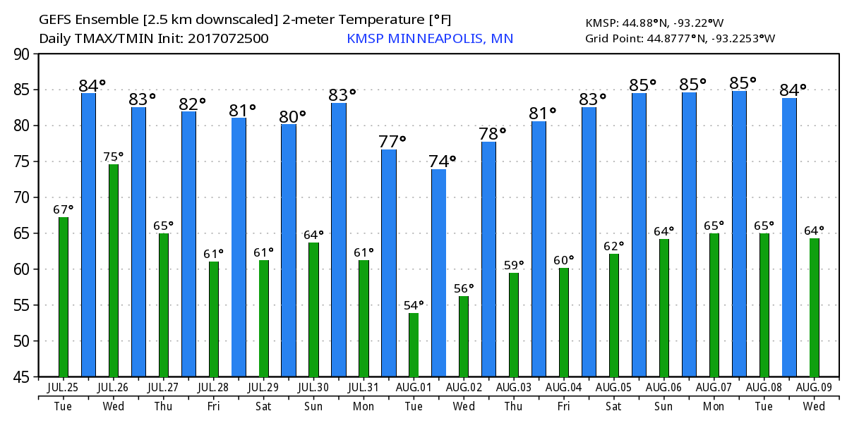
Minneapolis Temperature Outlook
Here’s the temperature outlook through August 9th, which shows temperatures hovering in the 80s through the rest of the month. However, there could be a little dip into the mid/upper 70s through the first few days of August before temperatures sneak back up into the 80s for the first weekend of August.
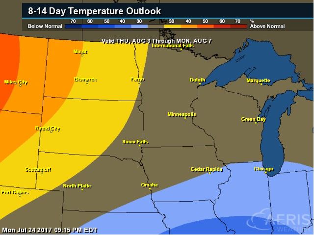
According to NOAA’s CPC, the extended temperature outlook from August 3rd to August 7th suggests cooler than average temperatures moving south into the central part of the country, while warmer than average temperatures will begin settling into the High Plains.
___________________________________________________________
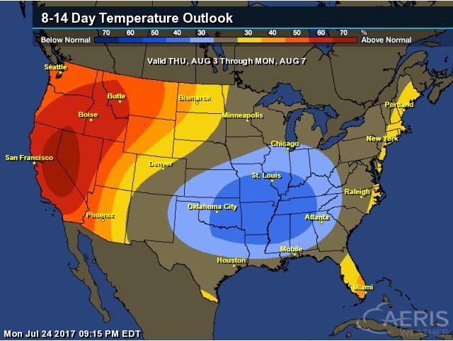
Extended Temperature Outlook
According to NOAA’s CPC, the extended temperature outlook through August 7th shows that a large chunk of the Central US will be dealing with cooler than normal temperatures, while the western part of the country will still be above average.
Extended Temperature Outlook
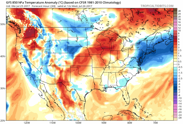
Here’s the extended 850mb temperature anomaly loop into early next. This describes how warm or cold (from average) mid/low level temperatures will be over time. Note that the warmer oranges and reds will begin to settle in along the northern tier of the nation through the end of the month/early August, but there some cooler than average temps settling in across the Central US as well.
____________________________________________________________
Weather Outlook Ahead
The weather outlook over the next couple of days shows stormy weather moving across the Midwest, Ohio Valley, Great Lakes and eventually into the Eastern US. There will also be continued monsoon storms in the Southwest that could lead to flash flooding.
.gif)
5 Day Precipitation Outlook
According to NOAA’s WPC, the next several days could produce areas of locally heavy rainfall across many areas from the Desert Southwest to the Midwest and eastern half of the country. Some of the heaviest rainfall could add up to as much as 1″ to 3″+, which could also lead to areas of localized flooding.
.gif)
____________________________________________________________________
“California, which has long been a pioneer in fighting climate change, renewed its commitment to reducing greenhouse gas emissions last week by extending, to 2030, its cap-and-trade program, which effectively puts a price on emissions. It’s a bold, bipartisan commitment that invites similarly ambitious policies from other states, and it sends a strong signal to the world that millions of Americans regard with utmost seriousness a threat the Trump administration refuses to acknowledge, let alone reckon with. The cap-and-trade program, which had been set to end in 2020, is the most important component of California’s plan to reduce planet-warming emissions by 40 percent (from 1990 levels) by 2030. The extension, along with a companion bill to reduce local air pollution, was passed by a two-thirds majority of the State Legislature, including eight crucial votes from Republicans. They defied a Republican president who has not only reneged on America’s global climate commitments, but has tried to undo every climate policy put into place by former President Barack Obama.”
(Image Credit: Rose Wong via NYTimes)

_____________________________________________________________
“A Comic Strip Mirrors the Ravages of Climate Change”
“The newspaper comic strip “Arctic Circle,” by the environmentally minded cartoonist Alex Hallatt, is about talking penguins and their fellow creatures living in the north. Starting Monday, under a caption that says “An Inconvenient Truth,” the menagerie will find their world shrinking and their conversations will be about global warming. Readers will see the drawings diminish to nothing by Friday as a snow bunny muses, “Climate change will lead to habitat loss and the extinction of many species.”Miss Hallatt created the strips to observe the arrival of the documentary “An Inconvenient Sequel: Truth to Power,” in theaters on Friday. The film is a follow-up to the 2006 Oscar-winning documentary featuring Al Gore. Miss Hallatt has no official connection to the film.”
(The cast of “Arctic Circle,” by the cartoonist Alex Hallatt, includes three penguins, a polar bear, a lemming and a bunny. Cre(ditAlex Hallatt/King Features Syndicate))

_______________________________________________________________________
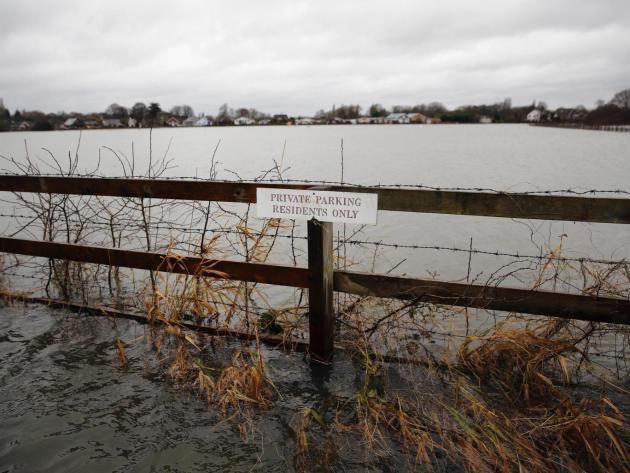
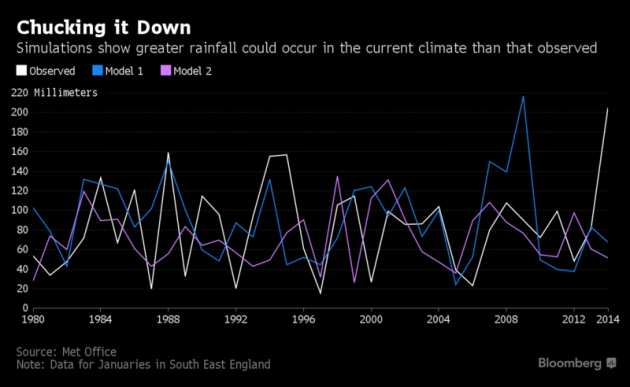
“Climate change brings one-in-three chance of record rainfall, warns Met Office”
“There is now a one-in-three chance of record rainfall hitting part of England and Wales each winter, according to new Met Office study which highlights the risk of major flooding as the climate warms. The researchers warned that global warming would change the risk of extreme weather and suggested politicians should bear this in mind when planning to protect the public, businesses and infrastructure. A series of storms in the winter of 2013-14 caused widespread flooding and about £1bn-worth of damage in the Thames river valley. Writing in the journal Nature Communications, the Met Office team said they had used computer models of the climate to show that those storms “could have been anticipated”.”
See more from Independent HERE:
(A series of storms in the winter of 2013-14 caused widespread flooding Getty via Independent)
___________________________________________________________________
“Climate change challenges sinking city of Venice”
“The Italian city of Venice is prone to frequent flooding because it has sunk five inches over the last century, but it is also grappling with a new challenge: sea-level rise, caused by climate change, which increases the severity. NewsHour Weekend Special Correspondent Christopher Livesay reports on the risks, and Italy’s plans to mitigate them, as part of our series “Peril and Promise,” on the challenge of climate change.”
(Image Credit: PBS)

__________________________________________________________________
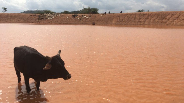
“As The Climate Changes, Kenyan Herders Find Centuries-Old Way Of Life In Danger”
“Out here, in West Pokot County, Kenya, the landscape looks like Mars — red clay, rocks, and in the distance, a mountain so bare it looks like a giant boulder. Stephen Long’uriareng, 80, has walked two hours to bring her two cows and goats to this watering hole. It’s really just a dam carved out the earth, where the rain water mixes with mud and turns into a dark brown color. This is not the place Long’uriareng remembers from her youth. “This whole place used to be green with a lot of pasture. There was nothing being experienced like drought,” she said.”
(As the drought has extended into yet another rainy season, some herders walk for hours to get to this dam. Eyder Peralta/NPR)
 _____________________________________________________________________________
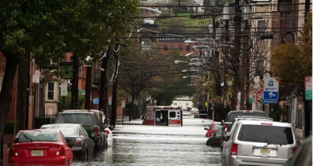
“This mayor is leaving politics to fight climate change full-time”
“Like many communities skirting the U.S. coastline, Hoboken, New Jersey, wasn’t built on solid ground. Many of its charming brick buildings, historic piers, and apartment towers stand atop what was once a low-lying tidal marsh — a grassy, muddy buffer along the Hudson River, designed by nature to absorb high tides and storm surge like a sponge. Early developers drained the marshlands in the 1800s to make way for modern Hoboken: the birthplace of singer Frank Sinatra, the location of TLC’s Cake Boss, and home to 53,000 people packed within the 1.25-square-mile city limit. Across the river, Manhattan’s glassy skyscrapers sparkle in the summer sunlight.”
See more from Mashable.com HERE:
(Hoboken’s streets are flooded in the aftermath of Hurricane Sandy on Oct. 30, 2012. IMAGE: MICHAEL BOCCHIERI/GETTY IMAGES)
_____________________________________________________________
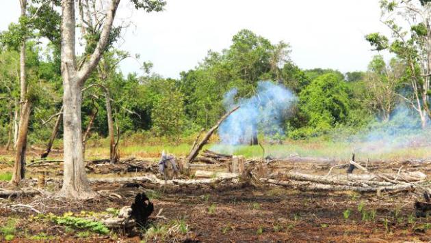
“A super-simple strategy may be key to fighting climate change”
“A key strategy in the fight against climate change is slowing the rapid destruction of the world’s forests. When trees burn or decompose, they release carbon. About 10 percent of the greenhouse gases emitted every year are from this newly freed carbon rising into the atmosphere. In recent years, developed countries have committed billions of dollars to help developing countries prevent deforestation. Some of the funds have been used to pay landowners not to cut down their trees. Part of the goal is to give landowners income that isn’t dependent on clearing land for agriculture or selling timber to meet big expenses.”
(A small patch of forest still burns after being cleared for farming in West Kalimantan, Indonesia. Credit: Titis Setianingtyas/PRI)
_____________________________________________________________
“How does climate change impact you?”
“Most people in Idaho believe climate change will not impact them. They think polar bears may be in trouble, or that people that live along the coast may have problems, but they don’t think it will cause problems in Idaho anytime soon. In reality, climate change is already impacting most of us in one way or another. Anyone who buys insurance is seeing the cost increase. More storms, more fires, more floods; about 5 times more severe weather events than we had 50 years ago. This means higher insurance premiums. Federal agencies are having to cut back on road maintenance, campground maintenance and nearly everything else because they are spending nearly half of their budget fighting fires. City, county, and state governments are having to increase taxes and/or reduce services with the added costs from severe storms.”
See more from IdahoSateJournal HERE:

________________________________________________________________
“U.K. Braced for Record-Breaking Wet Winters Blames Climate Shift”
“Britain faces a future of record-breaking wet winters, potentially leading to more of the widespread flooding seen in recent years, according to new modeling that incorporates changing climate patterns. England and Wales now have a 34 percent chance of record rainfall between October and March, the study by the government’s Met Office said on Monday. In 2013, heavy rain deluged parts of Cornwall and the south east. That was followed by three named storms that flooded some of Cumbria, Lancashire and Yorkshire in December 2015, while Storm Angus battered parts of Britain last November.”
_________________________________________________________________
“North Korea experiencing worst drought in 16 years, UN agency reports”
“North Korea is experiencing its worst drought since 2001, prompting officials to fear an increase in food shortage in the communist country that has suffered serious famine for years, a report by a United Nations agency revealed. The U.N. Food and Agriculture Organization released the report on Thursday that detailed a prolonged dry period in North Korea from April to June, an important time for crop development. It’s production of staple crops such as rice, corn, potatoes and soybeans has been damaged, “threatening food security for a large part of its population,” the agency said.”
(Image Courtesy: FoxNews)
 __________________________________________________________________
Thanks for checking in and don’t forget to follow me on Twitter @TNelsonWX

