Winter Weather Across The State
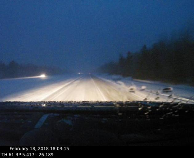
Snowy roads were the story across northern Minnesota Sunday, as heavy snow moved through the region. This was the view from one of the MNDOT plow cams just south of Two Harbors around 6 PM Sunday.
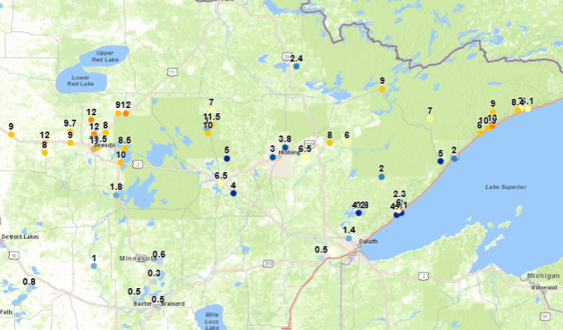
These were snow reports across north-central and northeast Minnesota through 6 PM Sunday night. The top total through this time frame was 13″ in Lutsen, with a number of 10-12″ reports in and around the Bemidji area. You can view an interactive version of this map (which will update with new totals as they come in, including totals Monday and Tuesday across southern Minnesota).
After heavy snow across parts of northern Minnesota Sunday, a second round of precipitation is expected across the state Sunday Night persisting into Tuesday. This will bring another round of heavier snow, especially across parts of central Minnesota, as well as freezing rain/ice across southern parts of the state.
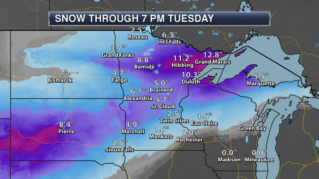
Note: Snowfall graphic above includes potential snow Sunday. The heaviest snow through Tuesday evening is expected across northern Minnesota, where parts of the Arrowhead picked up 6-8″+ of snow on Sunday (accounting for much of their snow projections seen above). That means some of the heaviest snow to begin the week will be across central Minnesota, where some areas could receive 3-6″ of snow by the time this complex system pushes through Tuesday. This will make travel slow and difficult at times.
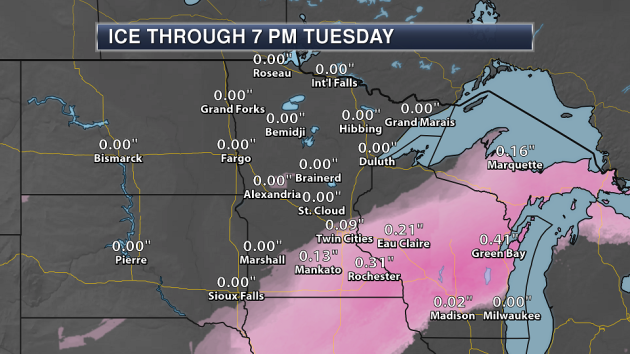
Ice will be heaviest across parts of southern Minnesota, where we could see between a tenth and a quarter inch of ice (or more) through Tuesday. This will cause travel headaches across this portion of the state, and could make it impossible.
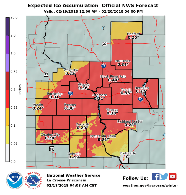
Here’s a closer view where some of the heaviest ice could fall across southeast Minnesota, where some ice totals could top a third of an inch.
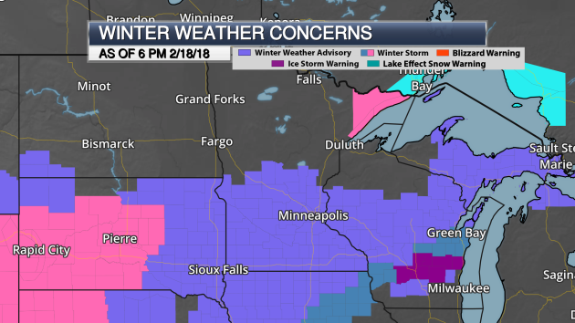
As of 6 PM Sunday, here were the alerts in effect across the state. Winter Storm Warnings across Cook and Lake Counties in northern Minnesota went through 9 PM Sunday evening for total accumulations of 10-15″ of snow. Winter Weather Advisories are in effect for central and southern Minnesota for 2-5″ of snow and (in parts of southern Minnesota) up to a tenth or two tenths of an inch of ice. Most of these are in effect until Tuesday, except across far southeastern Minnesota, where they are only in effect until 6 PM Monday due to Winter Storm Watches that start at that time.
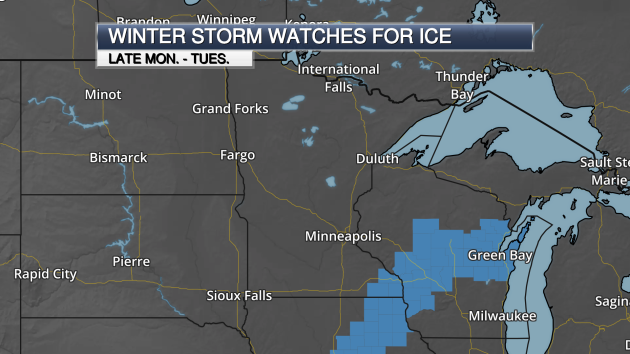
Here are where those Winter Storm Watches are in effect – from Iowa into southeast Minnesota and parts of Wisconsin. These are in effect for the potential of heavy ice accumulations late Monday into Tuesday.
_______________________________________________
Spring River Flooding Outlook
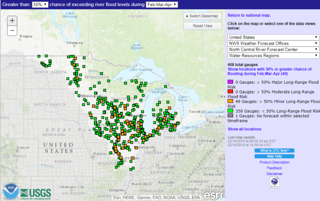
Last Thursday, NOAA River Forecast Center around the nation (including the North Central River Forecast Center) released their first look at the potential of spring river flooding. Across the upper Mississippi Valley, the North Central River Forecast Center stated the flood risk was near normal: “Overall, the flood potential for this area this spring is near normal, or perhaps slightly below normal for some spots. With a somewhat limited snow cover, at this point in time the risk for flooding due to snow itself is rather low. But with a cool spring anticipated based on the latest outlooks, and with some areas seeing deep frost, runoff rates could be enhanced due to the frozen ground, especially if the frost does not go out of the ground until later in the spring, or if heavy spring rains are seen. Behavior like this was already seen in a few places during the rain event in mid-January, so this will bear watching later this spring.”
In the metro area, the Minnesota River at Savage has about a 54% chance of exceeding minor flood stage this spring.
_______________________________________________
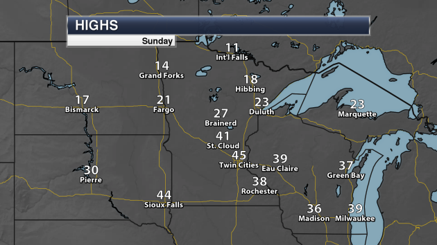
Highs Sunday (Through The Late Afternoon Hours)
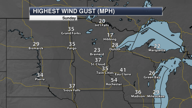
Peak Wind Gusts Sunday (Through The Late Afternoon Hours)
_______________________________________________
Fender-Bender Alert: Slushy Snow Mixes With Ice
By Paul Douglas
I don’t know about you but I prefer icing on my cakes and cookies, not on my commute. And here my meteorological prejudice is showing: I just don’t like ice.
At least one can rationalize snow; people love to play in it, it’s a source of soil moisture for farmers, covers up my dog’s digestive indignities, etc. But ice? Great tires, AWD, NOTHING much works on glaze ice. The only thing you can do is slow down and drive even more defensively.
As winters slowly warm friend and climate guru friend Mark Seeley has seen a 4X increase in midwinter ice since 2000.
March is primetime for slushy storms and potholes, and I predict no shortage of either in 2018. A little ice mixes in with the wet snow this afternoon. A second wave of light snow late tonight into Tuesday morning will keep roads icy and dicey. I’ll be amazed if the metro area picks up 1-3 inches of mushy snow. Plowable amounts for central Minnesota with a tenth of an inch of ice over southeast Minnesota; enough to bring down a few power lines.
ECMWF models shows an extended thaw late February into early March. High-five.
_______________________________________________
Extended Twin Cities Forecast
MONDAY: Icy coating to 1 inch. Low 20. High 22. Chance of precipitation 80%. Wind NE 10-20 mph.
TUESDAY: Light snow tapers. MSP total: 1-2″. Low 17. High 21. Chance of precipitation 70%. Wind NW 8-13 mph.
WEDNESDAY: Partly sunny, better travel conditions. Low 7. High 20. Chance of precipitation 10%. Wind NW 5-10 mph.
THURSDAY: Light snow arrives PM hours. Low 11. High 26. Chance of precipitation 40%. Wind SE 5-10 mph.
FRIDAY: Intervals of sun, a bit milder. Low 15. High 31. Chance of precipitation 20%. Wind NW 5-10 mph.
SATURDAY: Flurries or light snow possible. Low 22. High 34. Chance of precipitation 50%. Wind E 5-10 mph.
SUNDAY: Mostly cloudy, a drier day. Low 23. High 32. Chance of precipitation 20%. Wind W 7-12 mph.
_______________________________________________
This Day in Weather History
February 19th
1928: A dust storm moves across Minnesota, causing lights to be turned on in the daytime in the Twin Cities.
_______________________________________________
Average Temperatures & Precipitation for Minneapolis
February 19th
Average High: 30F (Record: 59F set in 2017)
Average Low: 14F (Record: -20F set in 1941)
Average Precipitation: 0.02″ (Record: 0.72″ set in 1952)
Average Snow: 0.3″ (Record: 8.3″ set in 1952)
_______________________________________________
Sunrise/Sunset Times for Minneapolis
February 19th
Sunrise: 7:07 AM
Sunset: 5:46 PM
*Length Of Day: 10 hours, 39 minutes and 19 seconds
*Daylight Gained Since Yesterday: ~2 minutes and 59 seconds
*Next Sunrise at/before 7 AM: February 24th (6:59 AM)
*Next Sunset at/after 6 PM: March 1st (6:00 PM)
_______________________________________________
Minnesota Weather Outlook
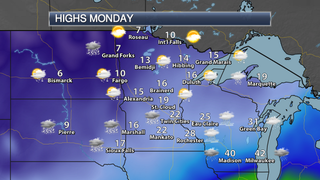
We’ll be watching snow chances across most of the state on Monday, with some freezing rain across parts of southern Minnesota. Far northern Minnesota may escape, though, and see a bit of sunshine. Highs will range from the 20s across southern Minnesota to single digits across northwest Minnesota.
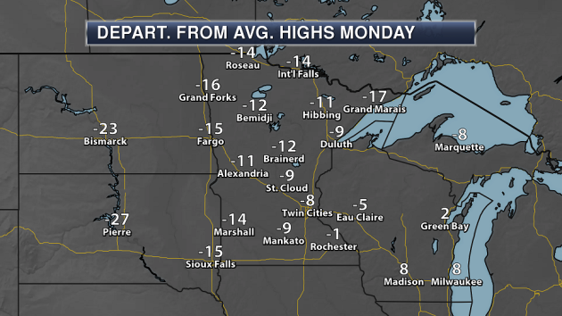
Highs across most of the state Monday will be a good 5-15 degrees below average for this time of year. The best chance of seeing above average temperatures will be in far southeastern Minnesota.
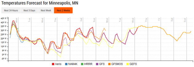
While we’ll see cooler temperatures (teens and 20s) through the beginning and middle of the week, we do see 30s return as we head toward Friday and next weekend.
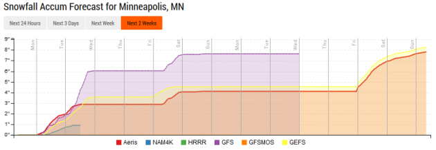
After the snow to begin the week across the Twin Cities, our next shot of snow will move in Friday and Friday Night as another system passes through the region, bringing the potential of another couple inches of snow at the moment.
_______________________________________________
National Weather Forecast
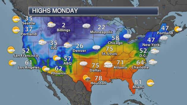
Messy weather is expected across a good portion of the nation Monday, with snow expected from the Great Basin and Rockies into the northern Plains. Ice can be expected from eastern Nebraska into parts of the Great Lakes. Meanwhile, rain can be expected from Texas into the Ohio Valley and Mid-Atlantic, as well as in parts of the Southwest.
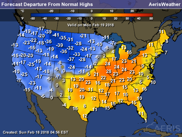
There will be a stark temperature difference across the country Monday, with parts of the Ohio Valley into the Southern Plains 20-30 degrees above average, but parts of the northern Rockies will be up to 40 degrees below average!
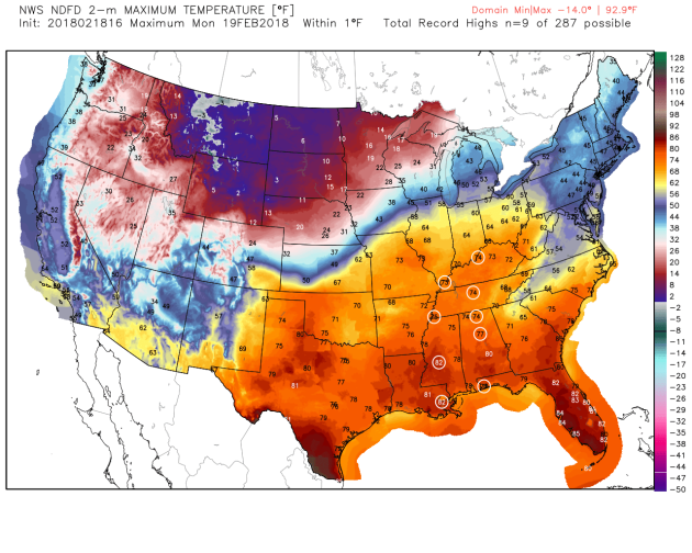
In that warm sector, record highs will be possible from Louisville south to New Orleans and Pensacola on Monday.
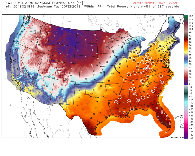
And there will be even more record highs on Tuesday across the eastern United States as the heat ramps up – potentially 54 record highs as 60s are likely as far north as Michigan and Massachusetts.
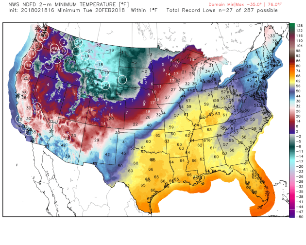
Meanwhile, many record lows will be possible in the western United States to wake up Tuesday morning.
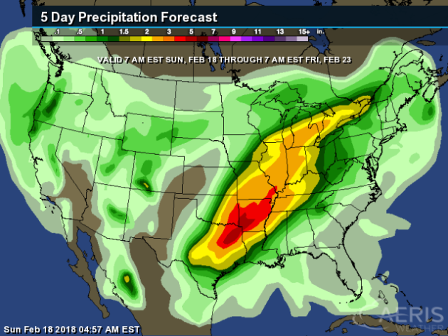
Heavy rain is expected from Tuesday into the middle of the week from Texas into the Great Lakes, where there is the potential of 3-5″+ of precipitation in just a few days time. We will have to watch the potential of flash flooding with this heavy rain.
In fact, the Weather Prediction Center already has a moderate risk of excessive rainfall that would lead to flash flooding from Texas into southern Missouri for Tuesday.
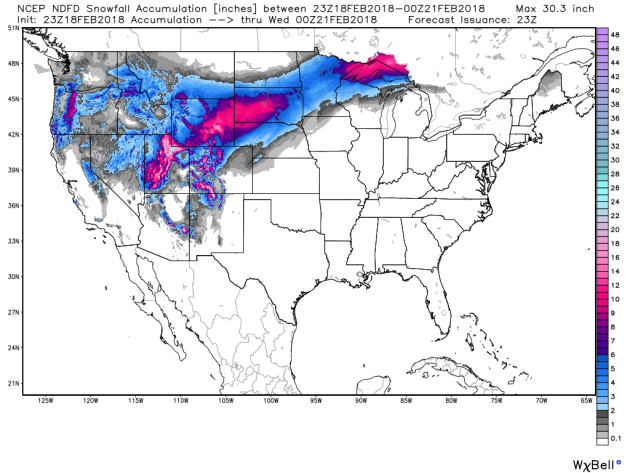
Heavy snow – on the order of at least a half a foot – is expected from the Great Basin into South Dakota and across parts of the Arrowhead of Minnesota from Sunday evening through Tuesday evening.
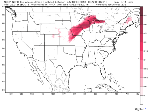
Ice will fall from northeast Kansas and eastern Nebraska to the upper Great Lakes. The greatest ice is expected across parts of northern Iowa into Wisconsin, where over a quarter inch of ice could fall.
_______________________________________________
State Of Emergency In West Virginia Due To Flooding
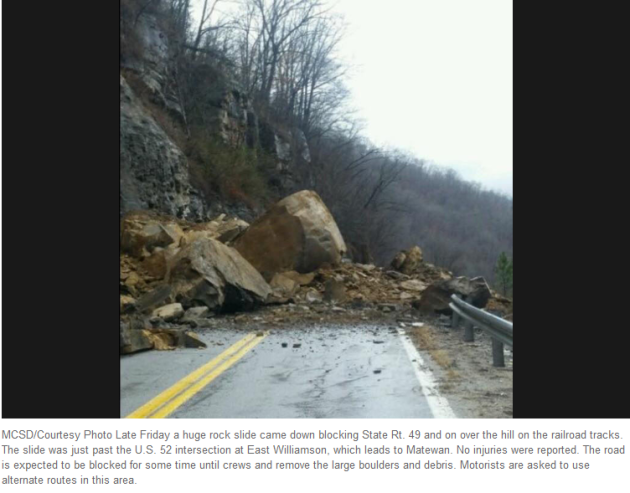
Officials are monitoring numerous rivers across West Virginia for the potential of flooding over the next several days. The Herald-Dispatch has more: “With weather conditions quickly getting worse, Gov. Jim Justice declared a state of emergency Saturday and put the West Virginia National Guard on standby as heavy rain pummeled West Virginia and caused flooding that was expected to continue throughout the weekend.State emergency officials were put on enhanced watch status and charged with monitoring the situation in all 55 counties, according to a news release. Rain mixed with snow fell in parts of the Tri-State and northern West Virginia, and the National Weather Service in Charleston expected precipitation to continue throughout the weekend.”
Drought Continues In Missouri, Could Affect Spring Planting
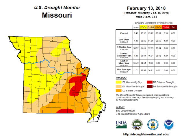
With drought ongoing in Missouri, farmers are already considering what they will do with crops this spring. More from the Colombia Missourian: “This winter’s had its share of ups and downs, especially temperature. What it hasn’t had much of is rain or snow. Last week, more than 99 percent of Boone County was considered to be in moderate drought, according to data by the National Drought Mitigation Center at the University of Nebraska – Lincoln. At this level, some damage to crops and pastures can be expected, as well as some water shortages. “There are signs that it may be trending a little worse than that,” said Mark Fuchs, senior service hydrologist for the National Weather Service in St. Louis.”
Senator Murkowski Wants GOP To Take Climate Change Seriously
However, her score from the League of Conservation Voters is only 19% and just voted to open up areas of Alaska to oil drilling. Baby steps? More from Grist: “Republican Lisa Murkowski says it’s time for her party to take climate change seriously. “Why is it politically charged to say climate change?” the Alaska senator asked during a speech on Wednesday. “I see in my state the impact we have from warming temperatures.” She makes a good point. Alaska is experiencing coastal erosion, bigger storms, and melting permafrost.”
Bats Also Impacted By Climate Change
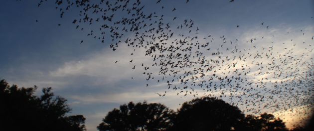
Add another animal to the list that climate change is affecting: bats. More from futurism: “We’ve reported in the past on how climate change is impacting wildlife around the world: from causing the Australian rat to go extinct, to forcing other species to adapt to survive. Perhaps unsurprisingly, we can now add bats to the list of those affected by the ever-changing climate, as they’re creatures that tend to travel to warmer areas when temperatures begin to drop. When they travel, bats usually do so in a swarm consisting of millions. When Mexican free-tailed bats bats migrate from Mexico to the Bracken Cave in San Antonio, Texas, the size of the swarm is so large it can be tracked using weather radar.” Image: Bats leaving Bracken Cave in Texas to feast on nearby insects. Image Credit: Phillip Stepanian/Rothamsted Research
_______________________________________________
Thanks for checking in and have a great Monday! Don’t forget to follow me on Twitter (@dkayserwx) and like me on Facebook (Meteorologist D.J. Kayser)!
– D.J. Kayser

