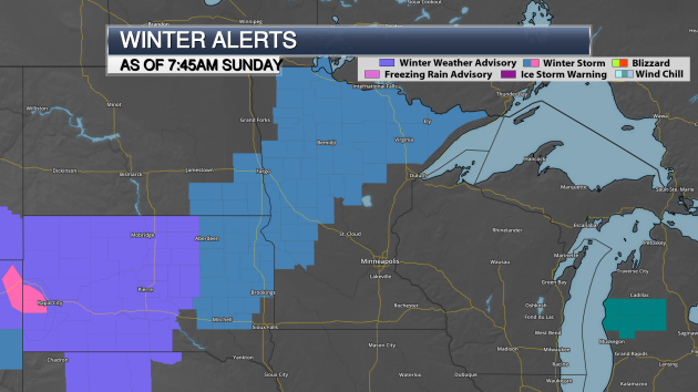
Sunday Morning Winter Storm Watch Update

Winter Storm Watches have been extended to include more of northern and western Minnesota than what they covered last night. The heaviest snow is still expected to fall over parts of north-central Minnesota and the Arrowhead, where snowfall totals of 4-7″+ are possible. For other parts of the Winter Storm Watch, including areas like Bemidji, Brainerd and Morris, only 2-5″ of snow is expected. However, these portions of the Winter Storm Watch are in effect due to the potential of blizzard conditions, with winds gusting as high as 55 mph Monday and Monday Night causing blowing and drifting.
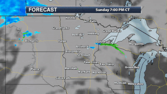
Here’s a look at the forecast through Tuesday morning. While some snow will be possible tonight across northern Minnesota, the event doesn’t get going until Monday as a band of snow sweeps in from the west across the state. Snow will linger into Monday Night and Tuesday, especially across northern Minnesota.
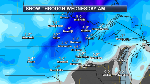
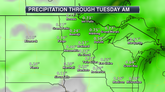
Here’s an updated look at snow totals through the early part of the week. Areas as close as St. Cloud could pick up an inch and a half of snow, but the heaviest totals will be to the north. Bemidji could pick up over 5″ of snow, with International Falls approaching 10″ through Wednesday morning (this includes any snow that may fall later today across the region as well).

Winds will be on the increase throughout Monday, with wind gusts topping 40 mph in parts of western Minnesota during the afternoon hours.
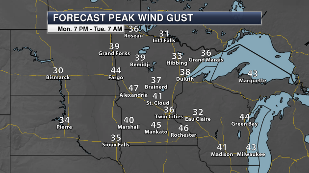
Strong winds will continue throughout Monday night, with wind gusts potentially peaking around 47 mph in Alexandria, helping to reduce visibilities due to blowing snow. The National Weather Service says that significant drifting of snow will also be possible. We could see wind gusts over 35 mph in the Twin Cities as well.

Even though snow will be over by Tuesday across western Minnesota, and slowly coming to an end across northern Minnesota, Tuesday will still be a blustery day across the state, with numerous areas seeing wind gusts over 30 mph.
_______________________________________________
November Recap
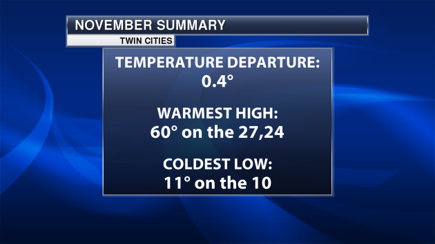
Even though we started the month off on a very cold note in the Twin Cities, a warm end to November helped the month end slightly above average in the temperature department. The warmest high of the month was 60, reached both on the 24th (which was a record for the day) along with the 27th. The coldest low was on the 10th when we dipped to 11 degrees.
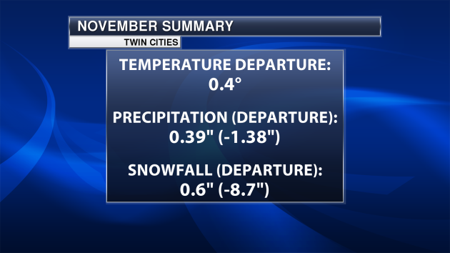
We didn’t see a lot of precipitation or snow during November. We were below average in both categories – especially with snow. The Twin Cities only saw 0.6″ of snow last month, 8.7″ below average.
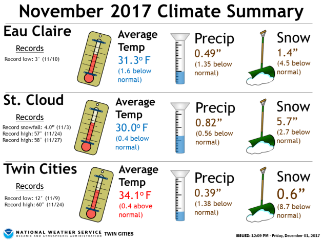
Not only did the Twin Cities see a record high on the 24th, we saw a record low on the 9th when the temperature dropped to 12. Three records were set in St. Cloud last month (two daily record highs and one daily snowfall record) meanwhile Eau Claire saw a record low of 3 on the 10th. All three locations shown above saw below average precipitation and snowfall.
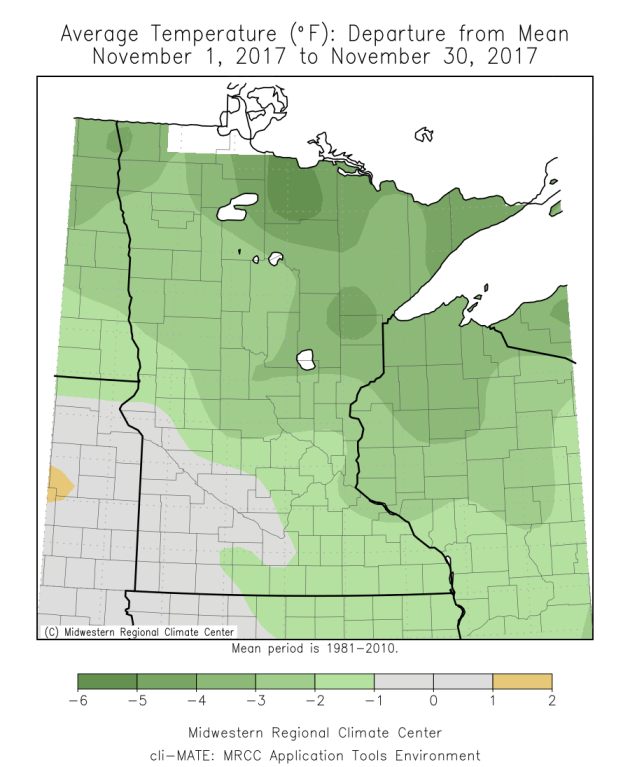
Even though we saw that warm end to the month, we can see that the cold start to the month helped keep the average temperature below average across many areas of the state.
_______________________________________________
Winter Makes A Return This Week – 20s By Tuesday?
By D.J. Kayser, filling in for Paul Douglas
Here’s your fair warning: Old Man Winter is waking up this week, and sending us a blast of cold air.
Today and Monday will be the warmest days of the foreseeable future as a system passes through the upper Midwest early this week. Besides a blast of cold air, this system will also bring some precipitation. This will start off as rain tonight into Monday before changing over to some snow by Monday Night. Snow totals look to be under an inch in the Twin Cities, with higher amounts across western and northern Minnesota.
This push of cold air will help keep highs below freezing and potentially not even reaching 20 at times this week. Just to put it into perspective, the last time we saw a high in the teens in the Twin Cities was almost nine months ago (March 10th). However, this would be right around average for the first sub-20 high if we were to see one this week.
Canada will continue to send more shots of cold air our way into the middle of the month. Hope you enjoyed the above average warmth while it lasted!
_______________________________________________
Extended Twin Cities Forecast
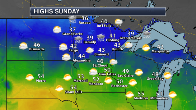
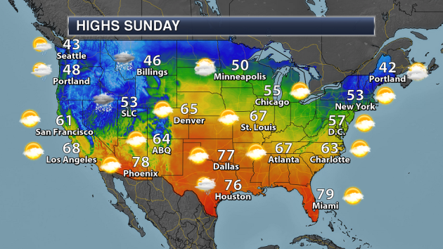
SUNDAY: Cloudy and warm. High 51. Low 44. Chance of precipitation 30%. Wind SE 5-10 mph.
MONDAY: Falling temperatures. Rain changes to snow by the evening. High 52 (set around noon, dropping after that). Low 21. Chance of precipitation 80%. Wind SE 5-15 mph.
TUESDAY: Back to reality temperatures. Blustery. High 24. Low 14. Chance of precipitation 10%. Wind NW 10-15 mph.
WEDNESDAY: Partly cloudy. Feels like 10-15. High 21. Low 12. Chance of precipitation 0%. Wind NW 5-10 mph.
THURSDAY: Flurries possible by the evening. High 22. Low 15. Chance of precipitation 20%. Wind W 5-10 mph.
FRIDAY: Cloudy skies. A touch warmer. High 27. Low 14. Chance of precipitation 0%. Wind NW 5-10 mph.
SATURDAY: Mix of clouds and sun. High 23. Low 10. Chance of precipitation 0%. Wind NW 10-15 mph.
_______________________________________________
This Day in Weather History
December 3rd
1998: Albert Lea soars to a record-setting 67 degrees.
_______________________________________________
Average Temperatures & Precipitation for Minneapolis
December 3rd
Average High: 31F (Record: 62F set in 1962)
Average Low: 17F (Record: -19F set in 1940)
Average Precipitation: 0.04″ (Record: 1.05″ set in 1953)
Average Snow: 0.4″ (Record: 7.4″ set in 1934)
________________________________________________
Sunrise/Sunset Times for Minneapolis
December 3rd
Sunrise: 7:33 AM
Sunset: 4:32 PM
*Length Of Day: 9 hours, 0 minutes and 11 seconds
*Daylight Lost Since Yesterday: ~1 minute and 27 seconds
*Latest Sunrise: December 30th-January 5th (7:51 AM)
*Earliest Sunset: December 5th-13th (4:31 PM)
________________________________________________
Minnesota Weather Outlook
Another day of warmth is expected across southern Minnesota, with highs reaching into the low 50s. Precipitation will be moving in as we head toward the evening and overnight hours, mainly in the form of mixed precipitation or snow across northern Minnesota, with rain across southern Minnesota.
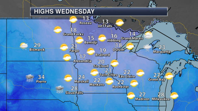
… As temperatures will look like this as we head into the middle of the week! We’ll barely make it into the 20s for highs across parts of southern Minnesota, with teens common to the north.
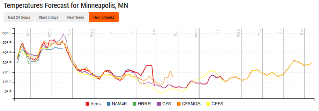
Old Man Winter is certainly making a return this week, after we get past the 50s Sunday and early in the day on Monday. Highs will only be in the 20s through the rest of the week and into next weekend, however we could struggle to make it out of the teens in the Twin Cities at times.
Between a quarter and a half an inch of precipitation (rain and melted snow) is expected across southern Minnesota through early in the week, with higher totals to the north (where heavier amounts of snow are expected).
After the rain and snow to begin the week, a few flurries will be possible late Thursday in the Twin Cities, otherwise no other precipitation is expected until the second full week of the month.
_______________________________________________
National Weather Stories
An area of low pressure will move through the Rockies Sunday, bringing some rain and snow along with it for places like Billings and Salt Lake City. The warm front associated with this system will bring the potential of rain and snow to parts of the upper Midwest by the evening hours. Upper level energy will help ignite some showers and isolated storms across the southern Plains and western Gulf Coast.
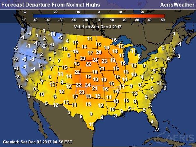
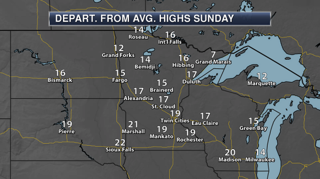
It you’re in the central and eastern United States, get out and enjoy the above average weather on Sunday. Departure from average highs will be largest across the central U.S., where they could be 20-25 degrees above average in areas.
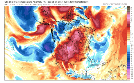
A rude awakening is coming for the eastern two-thirds of the country as a few blasts of cold air will sink south out of Canada this week. This will drop temperatures across the region below average at times.
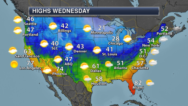
We can see that cold air sinking into the southern and eastern United States by Wednesday. Highs will only be in the 50s for areas like Atlanta and Charlotte, meanwhile they’ll be in the 20s for areas like the Twin Cities and Chicago.
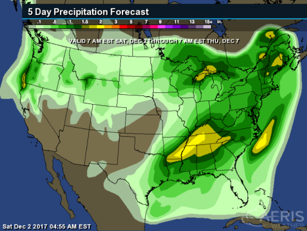
Some of the heaviest rain over the next five days is expected across the eastern and southern United States as we watch the same cold front bringing cold air to the region move through. Rain totals could top 2″ in spots.
_______________________________________________
Over 5,000 Schools Now Use Solar Power In The U.S.
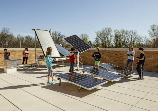
More schools across the country are using solar power – and teaching kids at the same time. More from InsideClimateNews: “In a field behind an elementary school in rural Middlesex County, Virginia, near the Chesapeake Bay, an ambitious plan has been taking shape: Schools Superintendent Peter Gretz and other local administrators are preparing to power their school district with solar energy. By next August, Virginia-based solar developer Sun Tribe Solar expects to have an array of solar panels in place in that field that can generate enough electricity to power the county’s elementary school and middle school—at a price well below their current electricity costs—while offering students, teachers and the community a way to learn about clean energy.” (Image: Students learn about some of the technologies used to harness solar energy in a rooftop lab at Discovery Elementary in Arlington, Virginia. The school has a 495-kilowatt solar array. Credit: Lincoln Barbour)
El Nino Increases Carbon Dioxide In The Atmosphere

A new study shows that El Nino could be contributing to climate change. More from Scientific American: “Every two to seven years, abnormally warm water in the Pacific Ocean causes an atmospheric disturbance called El Niño. It often makes extreme weather worse in various places around the world: greater floods, tougher droughts, more wildfires. Now scientists have new evidence indicating El Niño conditions might also add extra carbon dioxide to the atmosphere as well as lessen the ability of trees to absorb the greenhouse gas.” (Image: This picture taken on July 26, 2017 shows an Indonesian ranger inspecting the peat forest fire at Meulaboh, Aceh province. Credit: Chandeer Mayhuddin Getty Images)
Credit Downgrades Due To Inaction On Climate Change?
Moody’s has warned cities that if they don’t start preparations for climate change, they may see a downgrade in their credit rating. More from Bloomberg: “In a report to its clients Tuesday, Moody’s Investors Service Inc. explained how it incorporates climate change into its credit ratings for state and local bonds. If cities and states don’t deal with risks from surging seas or intense storms, they are at greater risk of default. “What we want people to realize is: If you’re exposed, we know that. We’re going to ask questions about what you’re doing to mitigate that exposure,” Lenny Jones, a managing director at Moody’s, said in a phone interview. “That’s taken into your credit ratings.””
________________________________________________
Thanks for checking in and have a great Sunday! Don’t forget to follow me on Twitter (@dkayserwx) and like me on Facebook (Meteorologist D.J. Kayser)!
– D.J. Kayser

