Hottest Ever Minnesota Temperature Recorded In 1917

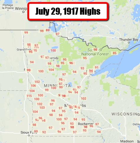
Saturday marks the 100th anniversary of the hottest temperature ever recorded in the state of Minnesota. That was a steamy 115 out in Beardsley, which is out in Big Stone County. As you can see, 90s and 100s were common across the state on that day with 100 as far north as Redby on Lower Red Lake and 108 in Thief River Falls. In the Twin Cities, we reached a high of 96 on that date, which technically wasn’t even a new record for the day (that was 97 set the year previously). Since then, though, we have broken the July 29th record in the Twin Cities, and it now sits at 98 set in 1999, 1975 and 1933.
_______________________________________________
Spectacular Stretch Of Weather Into Next Week
By D.J. Kayser, filling in for Paul Douglas
There is one thing that every person wishes for on a summer weekend: sunny skies and no rain. It’s the type of weather that allows you to get outside without the threat of having to find somewhere to take cover. So far this summer (since June 1st) we have had a total of three full weekends where no rain was reported at the Twin Cities airport. That has included the past two weekends, each of which saw a high in the 90s on Saturday then cooler conditions on Sunday.
Will we be able to make this the fourth weekend this summer without rain? We continue to watch the chance of a few isolated storms tonight into Sunday, mainly off to the north and west of the Twin Cities. However, most locations won’t likely receive any rain through the weekend. A better chance of rain moves in toward the middle of next week.
Highs will remain near average over the next seven days in the low to mid 80s. Just remember that it could be worse. On this date 100 years ago (in 1917), Beardsley hit 115F – the warmest high recorded in Minnesota history.
_______________________________________________
SUNDAY: Isolated storms north and west. Partly cloudy. High 82. Low 66. Chance of precipitation 10%. Wind S 3-8 mph.
MONDAY: A touch warmer. Sunny skies. High 85. Low 67. Chance of precipitation 0%. Wind S 3-8 mph.
TUESDAY: Sunny start. PM scattered storms. High 85. Low 67. Chance of precipitation 40%. Wind SW 5-10 mph.
WEDNESDAY: AM lingering showers. Mainly sunny. High 82. Low 64. Chance of precipitation 20%. Wind N 5-10 mph.
THURSDAY: Continued pleasant weather. High 80. Low 63. Chance of precipitation 10%. Wind SE 5-10 mph.
FRIDAY: A few passing clouds. Isolated shower potential. High 81. Low 62. Chance of precipitation 20%. Wind SW 5-10 mph.
_______________________________________________
This Day in Weather History
July 29th
1917: The hottest temperature ever recorded in Minnesota, 114.5 degrees, occurs at Beardsley.
1849: Severe storms hit the newly constructed post of Ft. Ripley between 3 and 5 AM. W.J. Frazier, Head Surgeon notes: ‘Rain and hail with much thunder and lightning and very high winds breaking many trees.’
_______________________________________________
Average Temperatures & Precipitation for Minneapolis
July 29th
Average High: 83F (Record: 98F set in 1999)
Average Low: 64F (Record: 47F set in 1971)
Average Precipitation: 0.14″ (Record: 1.11″ set in 1989)
________________________________________________
Sunrise/Sunset Times for Minneapolis
July 29th
Sunrise: 5:55 AM
Sunset: 8:42 PM
*Length Of Day: 14 hours, 47 minutes and 21 seconds
*Daylight Lost Since Yesterday: ~2 minute and 17 seconds
*Next Sunrise At/After 6 PM: August 2nd (6:00 AM)
*Next Sunset At/Before 8:30 PM: August 8th (8:29 PM)
_______________________________________________
Minnesota Weather Outlook
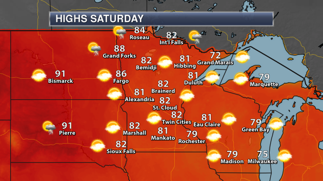
Another nice weather day is expected across the state as we head into Saturday, with highs in the upper 70s to mid 80s – right around average for this time of year. A few storms will be possible across northern Minnesota as we head into the late afternoon and overnight hours, but chances are sitting at about 20-30%.
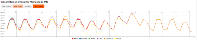
Temperatures will remain fairly steady over the next week, with highs in the low to mid 80s in the Twin Cities. Models are hinting at the potential of a warm up late next weekend, and that may be our next best shot at reaching 90 in the Twin Cities before cooler weather settles in again.
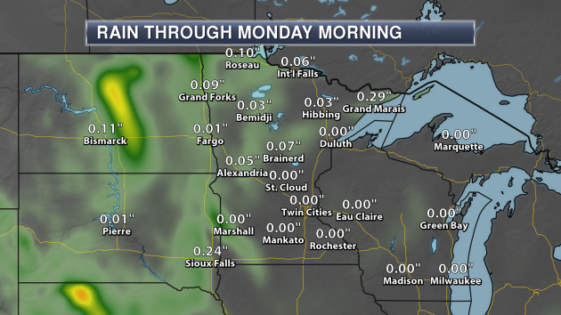
Through the weekend, the best chance of receiving any rain will be across parts of northern and western Minnesota. Even then, rainfall amounts are expected to be light across the region, mainly under a tenth of an inch.
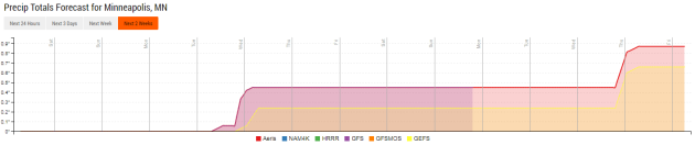
As we look at the extended precipitation forecast for the Twin Cities, the next best chance of rain looks to be Tuesday Night into early Wednesday. Some models are hinting at another chance of rain somewhere in the upper Midwest in the Friday timeframe, but there is disagreement as to where that rain could fall. After that, rain may not be possible until the first full week of August.
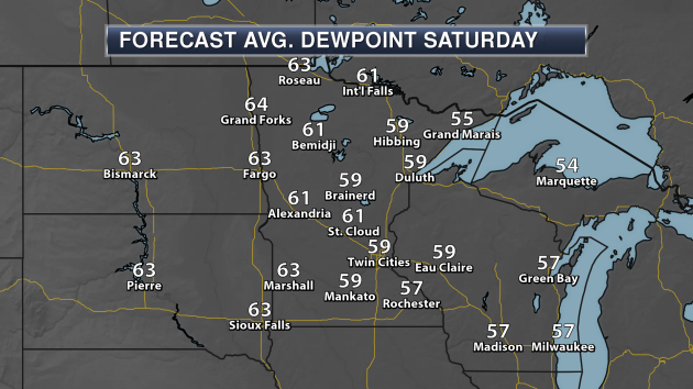
Taking a look at dew points across the region this weekend, Saturday will be the less humid day, with dew points in the Twin Cities on average just below 60. You can expect dew points in the 60s, however, if your travels take you west.
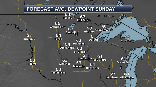
Dew points will climb a touch heading into Sunday, with most of the state seeing average dew points in the low to mid 60s.
_______________________________________________
National Weather Outlook
Saturday Forecast
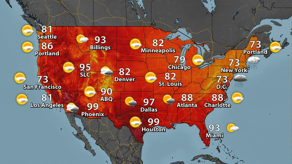
As an almost winter-like system moves up the eastern seaboard Saturday, rain is expected for places like D.C. and New York City as highs will only climb into the 70s. The heat will remain across portions of the south, with areas like Dallas and Houston expected to reach the mid to upper 90s. Monsoonal moisture (and therefore storms) will continue across the desert southwest, meanwhile the streak of no measurable rainfall days in Seattle and Portland will continue as highs climb into the 80s.
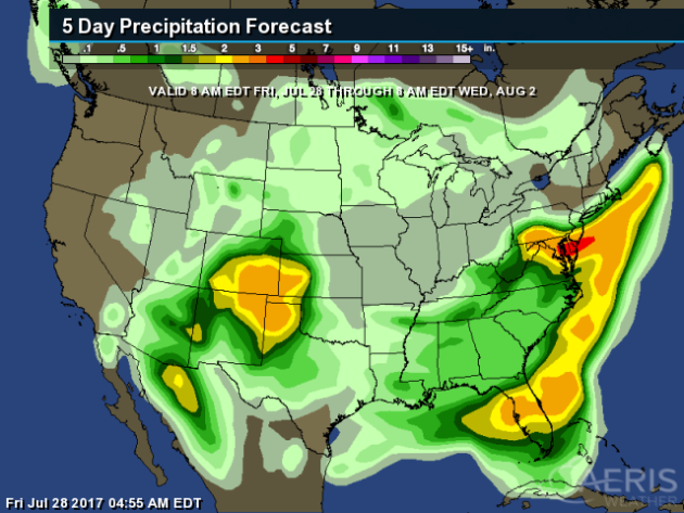
We can see the heavy rain expected from that system moving up the Mid-Atlantic and Northeast coasts over the next few days, with the potential of 2″+ of rain in some areas. Heavy rain is expected late this weekend and early next week in parts of Colorado, Kansas, Oklahoma, Texas and New Mexico, where totals could be over a couple inches in spots. As we head into next week, a moist southwest flow will develop across parts of Florida, leading to elevated rainfall totals into the middle of next week.
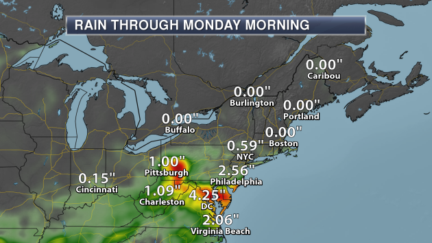
Here’s a closer look at some of the heavy rainfall totals expected in parts of the Northeast. Places like Philadelphia, D.C. and Pittsburgh could pick up on 1-4″+ of rain into the weekend. Due to the heavy rain expected, Flash Flood Watches have been issued across the region through Saturday.

In the Southwest, we could see heavy rain develop with monsoonal moisture in place as we head into the weekend. Meanwhile, areas like Colorado Springs and Albuquerque could pick up on more rain as a frontal boundary moves in late in the weekend.
_______________________________________________
The Biggest Wind Farm In The U.S. Will Be In Oklahoma

Who would of thought Oklahoma would have the biggest wind farm in the United States? GE is currently building it with Invenergy, and it is expected to be operational in 2020. More from Reuters: “Power development company Invenergy LLC and General Electric Co on Wednesday announced plans to build the largest wind farm in the United States in Oklahoma, part of a $4.5 billion project to provide electricity to 1.1 million utility customers in the region. The 2-gigawatt Wind Catcher wind farm is under construction in the Oklahoma panhandle and will come online in 2020. The facility will be linked to a 350-mile dedicated power line that will send the wind farm’s electricity to Tulsa.”
North Carolina Sees A Giant Increase In Solar Power

Numerous states have been quickly jumping on the solar power bandwagon over the past few years, with North Carolina being one of them. They saw the third largest increase in producing solar power since 2007. California and Arizona are the only states above North Carolina on the list. More from The News & Observer: “The Environment North Carolina Research and Policy Center noted advancements in the use of energy storage and electric vehicles in the state, which it also ranked 13th for energy efficiency. North Carolina has increased solar energy production from one gigawatt hour in 2007 to 4,016 in 2016, per the report.”
Record Breaking Temperatures In Miami
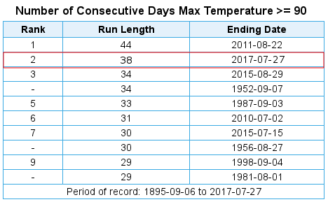
Records are being shattered this year in Miami, including approaching their most consecutive 90 degree days on record and even their hottest month on record. More from the Capital Weather Gang: “Miami is known for its steamy weather, but this year and this month, the city has shattered an astonishing number of records for hot weather. It’s having its hottest month ever recorded, and, so far, 2017 is its warmest year.”
Less Drinking Water In The Future?
Algal blooms could become more frequent in the future due to climate change… adnd that could actually lead to less drinkable water. More from WIRED: “LAST SUMMER, SOUTHERN Florida nearly ran out of water. It wasn’t drought—actually, the opposite. The state got way too much rain, which flushed nutrients from over-fertilized farms into its canals and reservoirs. All the extra food led to a massive algal bloom, a skim of blue-green slime that smells like rotten eggs and poisons humans. Governor Rick Scott declared a state of emergency in four counties.”
Exceptional Drought Expands in North Dakota, Montana
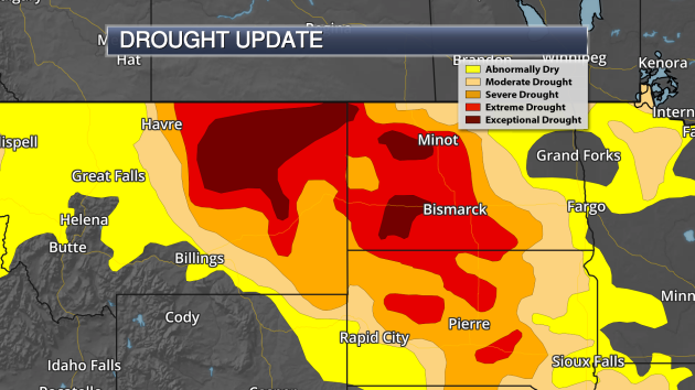
Exceptional drought continued to expand across portions of North Dakota and Montana in the latest update issued by the National Drought Mitigation Center Thursday. 7.6% of North Dakota is now under exceptional drought, up from 6.4% last week. 11.9% of Montana is now under exceptional drought as well, up from 1.5% last week. Here’s a snippet from the Drought Monitor on the conditions in the region: “Governors provided much-needed response to the dire drought impacts. Montana Gov. Steve Bullock issued an executive order declaring a drought disaster in 28 counties and five Indian reservations in the eastern part of the state. Nebraska Gov. Pete Ricketts issued an emergency proclamation, allowing the state Emergency Management Agency to address unmet drought needs, particularly those related to wildfires.”
Better Clouds… Better Forecast?

Could we get better forecasts just by representing clouds in the models better? That’s what scientists at CIRES, NOAA and the University of Wisconsin are hoping. More from the AGU Blogosphere: “Anyone with a cell phone camera and kids or dogs knows that resolution is “expensive”: taking lots of very high-resolution photographs and video clips can quickly fill a device. An analogous resolution challenge in weather and climate modeling has dogged modelers for years: Computationally, it’s just too expensive to represent certain clouds in the detail needed to make them behave realistically; yet clouds are critical to accurate weather and climate modeling. Now, a team of CIRES, NOAA and University of Wisconsin-Milwaukee experts has proposed a solution, and in a test, their new clouds even produced credible drizzle.”
Fake Blizzards For Better Planes

How do they make sure planes can fly through harsh conditions, like blizzards? Well, they test them in those conditions… in an indoor-weather testing building. More from Popular Science: “ON AUGUST DAYS IN THE FLORIDA PANHANDLE, the tropical heat steam-cooks everything. UPS drivers slap wet bandannas to their foreheads. Pirate-themed mini-golf parks, shimmering like mirages, lay deserted. But a few miles from the Gulf motels and sandy beach malls, engineers like Kirk Parrish face the worst snowstorms of their lives. Sheathed in parkas, they cold-start their pickups and drive straight into stinging, minus-40-degree whiteout blizzards. Indoors.” (Photo: U.S. Navy/Photo by Michael D. Jackson)
Phone Case Helps Prevent Overheating, Freezing
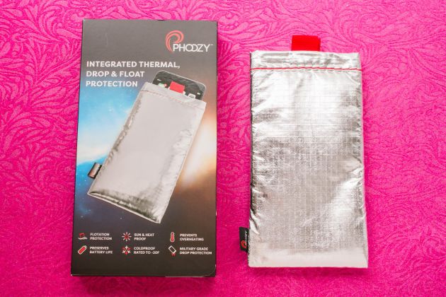
An phone case that can help keep your phone cool during the summer (and warm during the winter)? Sign me up! More on the Phoozy case (what a name…) from CNET: “A simple sleeve or “capsule” for smartphones that’s made out of spacesuit-inspired materials designed to protect astronauts, the Phoozy is the brainchild of Kevin Conway, a NASCAR driver and Lamborghini Super Trofeo World Champion who got tired of “having my phone overheat and shut down when I was outside on a hot summer day or freeze when I was snowboarding.” The Phoozy has a Chromium Thermal Barrier Shell and SpaceTech Penetration Layer, as well as a bit of velcro to keep it closed at the top. The secret to that Chromium Thermal Barrier is that it reflects 90 percent of the sun’s energy.” (Photo: Sarah Tew/CNET)
________________________________________________
Thanks for checking in and have a great Saturday! Don’t forget to follow me on Twitter (@dkayserwx) and like me on Facebook (Meteorologist D.J. Kayser)!
– D.J. Kayser

