Past Valentine’s Day Weather

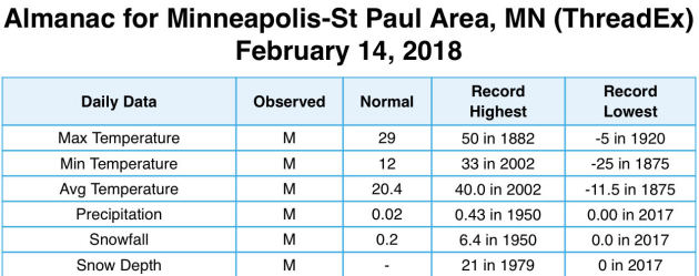
Early reminder: Valentine’s Day is Wednesday! Taking a look back at past Valentine’s Days, the warmest it has even been on February 14th is 50 back in 1882. We have had a high as cold as -5, though, which occurred back in 1920. The record low for February 14th is -25 set in 1875. 6.4” of snow fell in 1950 on Valentine’s Day, and only eleven years in Twin Cities history have had at least 1” of snow fall on that date.
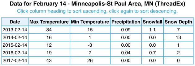
Over the past five years, we have had highs between 43 (2017) and 12 (2015) on Valentine’s Day, with snow falling only two out of the five years (the most: 1.1” in 2013).
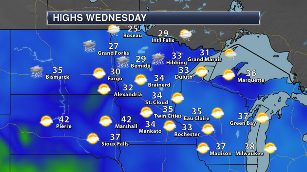
Here’s a look at what this Valentines Day could bring across the state. A little bit of snow will be possible across northern Minnesota, but sunny skies are expected in southern Minnesota. Highs will range from the 20s up north to 30s across southern Minnesota. As southern Minnesota will be in the warm sector, there’s even the possibility we could see some 40s.
_______________________________________________
Ideas to Make the Winter Olympics Great Again
By Paul Douglas
Every two years Americans put aside their differences to cheer on some of the most amazing athletes on the planet. The Winter Olympics is a much-needed distraction but we can make future games even better!
WCCO Radio co-host Jordana Green and I solicited advice from listeners Friday: pick a random spectator out of the crowd to compete in every event, for a little perspective. Competitive snow shoveling (and plowing), massive snow ball battles between nations, ice-fishing hole-drilling, toboggan races and ice-driving (like ice skating, only with vehicles). Maybe NASCAR can get involved? We will present our ideas to NBC and the IOC next week. Wish us luck.
Welcome to the Dog Days of Winter, a fairly boring stretch, as the wettest storms track south of Minnesota. February is 12F colder than average but models show a warming trend for the last half of the month, as prevailing winds blow from Seattle vs. The Yukon.
You’ll be able to exhale this week with a few 20s and 30s, 40F is possible Wednesday. We’ll see a few more subzero nights, but the worst polar pain is behind us now.
_______________________________________________
Extended Twin Cities Forecast
SUNDAY: Partly sunny. High 18. Low 0. Chance of precipitation 10%. Wind W 8-13 mph.
MONDAY: Sunny, still colder than average. High 17. Low 7. Chance of precipitation 10%. Wind NE 3-8 mph.
TUESDAY: Mix of clouds and sun – better. High 26. Low 19. Chance of precipitation 10%. Wind SW 7-12 mph.
WEDNESDAY: Pacific breeze. Time to wash the car. High 41. Low 26. Chance of precipitation 20%. Wind SW 10-15 mph.
THURSDAY: Mild start, then windy and cooler. High 31. Low 3. Chance of precipitation 10%. Wind NW 10-20 mph.
FRIDAY: Blue sky, whiff of wind chill. High 18. Low 8. Chance of precipitation 10%. Wind W 8-13 mph.
SATURDAY: Clouds increase, still breeze. High 32. Low 28. Chance of precipitation 20%. Wind S 10-15 mph.
_______________________________________________
This Day in Weather History
February 11th
1932: Mizpah picks up 13 inches of snow in a storm.
_______________________________________________
Average Temperatures & Precipitation for Minneapolis
February 11th
Average High: 28F (Record: 57F set in 1882)
Average Low: 11F (Record: -31F set in 1899)
Average Precipitation: 0.02″ (Record: 0.28″ set in 1965)
Average Snow: 0.2″ (Record: 4.1″ set in 1979)
_______________________________________________
Sunrise/Sunset Times for Minneapolis
February 11th
Sunrise: 7:19 AM
Sunset: 5:35 PM
*Length Of Day: 10 hours, 15 minutes and 51 seconds
*Daylight Gained Since Yesterday: ~2 minutes and 51 seconds
*Next Sunrise at/before 7 AM: February 24th (6:59 AM)
*Next Sunset at/after 6 PM: March 1st (6:00 PM)
_______________________________________________
Minnesota Weather Outlook
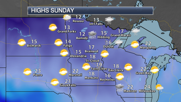
We could see our first 20 of February in the Twin Cities Sunday as highs climb to around 20 across most of southern Minnesota. Highs will remain in the teens across northern Minnesota, with the chance of some light snow.
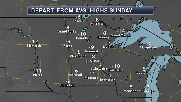
Despite warmer temperatures in place, highs will still be below average for this time of year by a good 5-10 degrees across the state.
We will continue to see warmer temperatures for most of the week ahead, with highs mainly in the 20s and 30s in the Twin Cities. Some cooler weather will move in, though, for the end of the week.
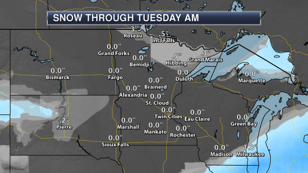
A cold front moving through northern Minnesota will bring the potential of a dusting to an inch of snow Sunday for areas like Roseau, International Falls and Grand Marais.
Here in the Twin Cities, there’s the potential of some light snow Tuesday and Saturday, but totals are expected to be light. Right now models show less than two inches falling this week across the metro area.
_______________________________________________
National Weather Forecast
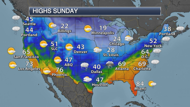
As a cold front continues to move east, rain, freezing rain and snow will be possible from the Southern Plains to Great Lakes and eastward to the coast Sunday. A second cold front will be diving south across the northern Plains and upper Midwest, bringing a snow chance to the upper Great Lakes. Rain and snow will be possible across the Northwest as a system moves into the region.

Warm weather will be found in the eastern portion of the nation Sunday, with highs 5-15 degrees above average ahead of a cold front. Behind that front highs will be below average, as much as 20 degrees below average across parts of the southern Plains.
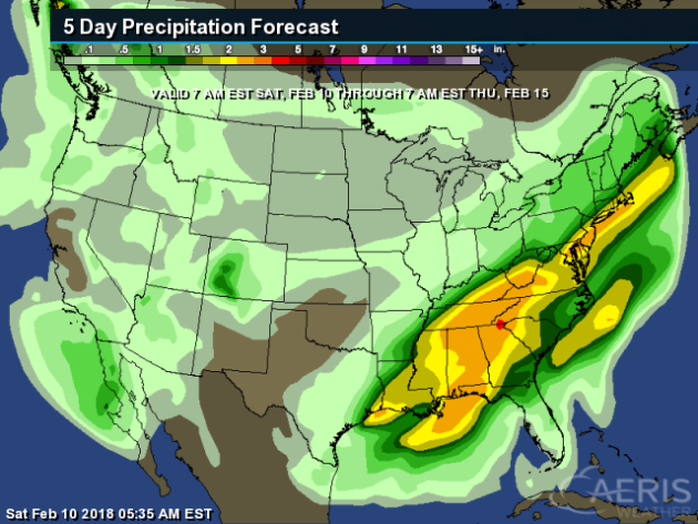
Heavy rain will be likely through the weekend across parts of the eastern United States, where totals could top 2-3” and has the potential to lead to flooding. A couple systems will lead to some precipitation Sunday and again midweek in the Northwest. In the Southwest, a cutoff low will bring the potential of showers during the week.
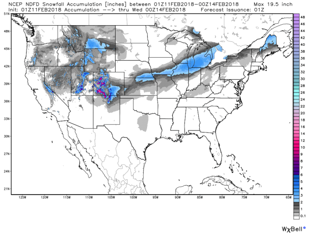
A few inches of snow will be possible through the end of the weekend and early in the week from the central Plains to the Northeast.
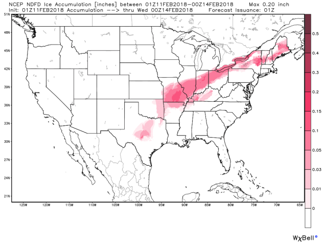
In between the heavy rain and snow potentials, we’ll watch the potential of up to a tenth or so an inch of ice through the rest of the weekend from Missouri into the Ohio Valley and parts of the Northeast. This will cause slick roads across the region.
_______________________________________________
Looking Back At January
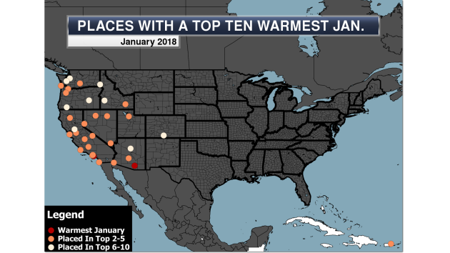
Both Long Beach, CA and Tucson, AZ saw their warmest January on record last month. More from Praedictix: “Warmth dominated out west during January 2018, with scattered areas of excessive rainfall across the country. We also saw quite dry areas of the nation, especially in parts of the South. In this edition of D.J.’s PraeDigits, we take a look back at January 2018 across the nation.”
Snow Drought In Colorado
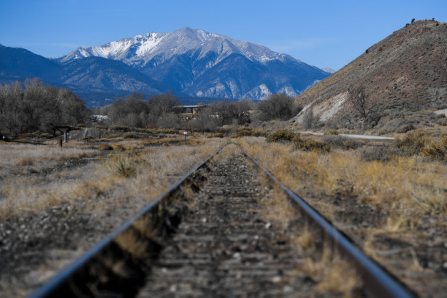
Snow isn’t only lacking in the Sierra this year – Colorado is also having a snow drought. More from the Denver Post: “Colorado mountain snowpack has bounced back a bit but remains exceptionally low, with the latest data showing the statewide average at 64 percent of the norm, and water suppliers say they’re anxious about prospects for drought. The snowpack at nearly a quarter of the federal government’s 200 monitoring sites around Colorado measured at the lowest or second lowest snowpack ever recorded, according to Brian Domonkos, supervisor of the U.S. Department of Agriculture’s Natural Resources Conservation Service snow survey.” (Image: AAron Ontiveroz, The Denver Post A view of a light dusting of snow on the mountains west of Salida on Thursday, Jan. 4, 2018. Colorado is experiencing a record low snowfall during the 2017-18 winter season.)
President Trump And The Deserts
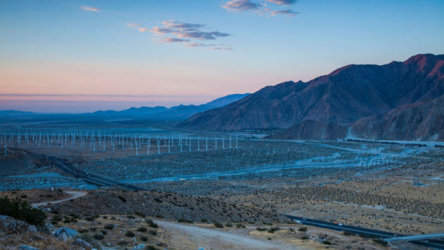
Could the Trump administration be taking aim on the deserts next? More from Earther: “The Trump administration’s move to start rewriting a plan for vast tracts of Southern California desert lands could have long-term repercussions for renewable energy production and wildlife conservation. The Department of Interior announced last week that it is taking public comments through March 19 “to help set the parameters” for a review of the Desert Renewable Energy Conservation Plan (DRECP), finalized in 2016 after seven years of collaborative planning. The agency is asking for comments on how the plan affects development of solar, wind, or other renewable energy resources, but environmentalists fear its another attempt to prioritize fossil fuels and mining over clean power and conservation.” (Image: BLM)
Smaller Animals Due To Climate Change?

Just another threat due to climate change: smaller animals. More from Earther: “Climate change is inducing some logically straightforward adaptations in plants and animals. As Earth’s temperature warms, species used to cooler climates make moves to escape the newfound warmth: Some bird species are shifting their ranges northward; some fish are moving towards the poles; and some plants are slowly moving upslope. But recent research has uncovered another, less immediately obvious adaptation: As temperatures go up, some species are becoming—or are predicted to become—smaller. ” (Image: Chamois mountain goat in its natural habitat. Image: Shutterstock)
_______________________________________________
Thanks for checking in and have a great Sunday! Don’t forget to follow me on Twitter (@dkayserwx) and like me on Facebook (Meteorologist D.J. Kayser)!
– D.J. Kayser
