60 F. high on Tuesday in the Twin Cities.
67 F. average high on September 27.
82 F. high on September 27, 2015.
.04″ rain fell at MSP International Airport yesterday.
September 28, 1983: Late summer-like temperatures arrive in Minnesota with 91 degrees at Montevideo and 90 degrees at Elbow Lake.
September 28, 1895: A ‘furious wind’ at Pleasant Mound in Blue Earth County blows down grain stacks and corn shocks.
One Word to Describe 2016’s Weather: “Mega”
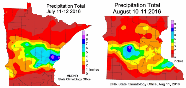
Live long enough and you’ll see almost everything. Even 2 “mega rains” in one year. A mega-rain is defined as 6 inches of rain over at least 1,000 square miles, with a core of 8 inches. “This is the first time we’ve seen 2 mega rains in 1 year” said Pete Boulay at the State Climate Office.
Boulay adds that the storm that unleashed over 10 inches on Waseca last week didn’t qualify as “mega”, because it only had 300-500 square miles of 6-inch rains. Welcome to what may become Minnesota’s wettest year on record, statewide.
Mother Nature must be a golf fan. Expect cool sun much of today as chilly winds ease up. Talk about serendipity: this year’s Ryder Cup (have you heard about this?) falls on some of the best weather of the entire year. A weak storm stalls over Michigan, but a bubble of high pressure overhead treats us to lukewarm sun & a cool breeze Thursday into Monday morning. Somehow we were able to squeeze a world-class golfing event between floods this year.
NOAA’s GFS run brings frosty air into the metro in 2 weeks. Will mega-rains give way to mega-snows?
Stay tuned.
2 Minnesota Mega-Rains in One Calendar Year. Here is what Pete Boulay, at the Minnesota DNR and State Climatology Office had to say about last year’s extreme rains in the Waseca area and the state of “mega-rains” in 2016:
“We have determined that the automated tipping bucket at the Waseca Airport is in error, especially the reading of 4 inches in one hour. The U of M Waseca manual gauge is about 1/2 mile away and has readings more representative of the area and what was seen on radar. The official gauge at the U of M Waseca site was 2.52 for the 21st and 7.64 inches on the 22nd for two-day total of 10.16 inches.
This event was not classified as a “mega” rain event because it only had about 300-500 square miles of six inches or more.
We did have two mega-rains in Minnesota for 2016.
July 11-12 http://www.dnr.state.mn.us/climate/journal/160711_12_flood.html
and August 10-11 http://images.dnr.state.mn.us/natural_resources/climate/journal/160810_11_heavy_rain.jpg
Yes, this is the first time we have seen two “mega” rains in one year, there may have been other “mega” rains before 1973 that we have not been able to document. The two events from 1866 and 1867 likely exceeded the “mega” rains that we saw this year.”
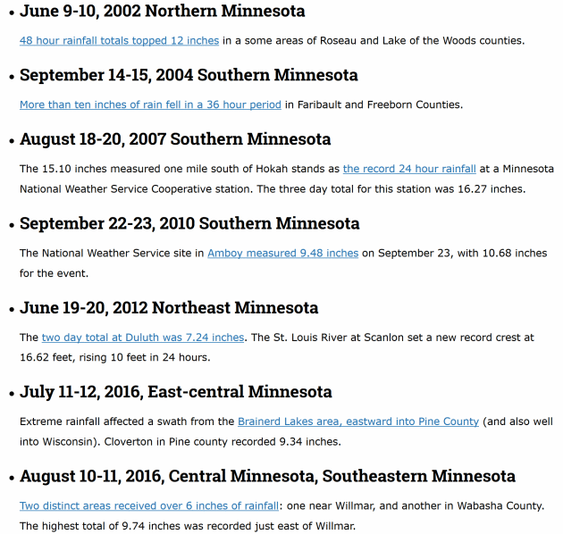
7 Minnesota Mega-Rains Since 2000. Details from the Minnesota DNR and State Climate Office. They write: “…If we examine the period 1973-2016, Minnesota has seen ten mega-rains. However, of these ten, two were in the 1970s, one was in the 1980s, none were in the 1990s, but the 2000s saw three and the 2010s, still underway, has seen four. Indeed, the frequency of these potentially disastrous events has been increasing sharply, and 2016 became the first year on record with two mega-rains in the state. These trends are consistent with the expectation that Minnesota and the Upper Midwest will receive more precipitation, and more precipitation from large events, in response to increasing global temperatures and increased available moisture for passing storm systems…”
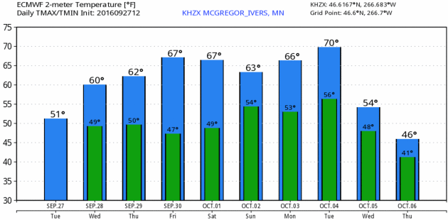
Slipping Into Autumn. The weather over the next few days looks fairly benign and pleasant; a temporary holding pattern will stall out a storm over Michigan for a couple of days, a weak ridge of high pressure treating Minnesota to intervals of sun, but clouds and showers increase as you drive east across Wisconsin. MSP Meteogram: WeatherBell.
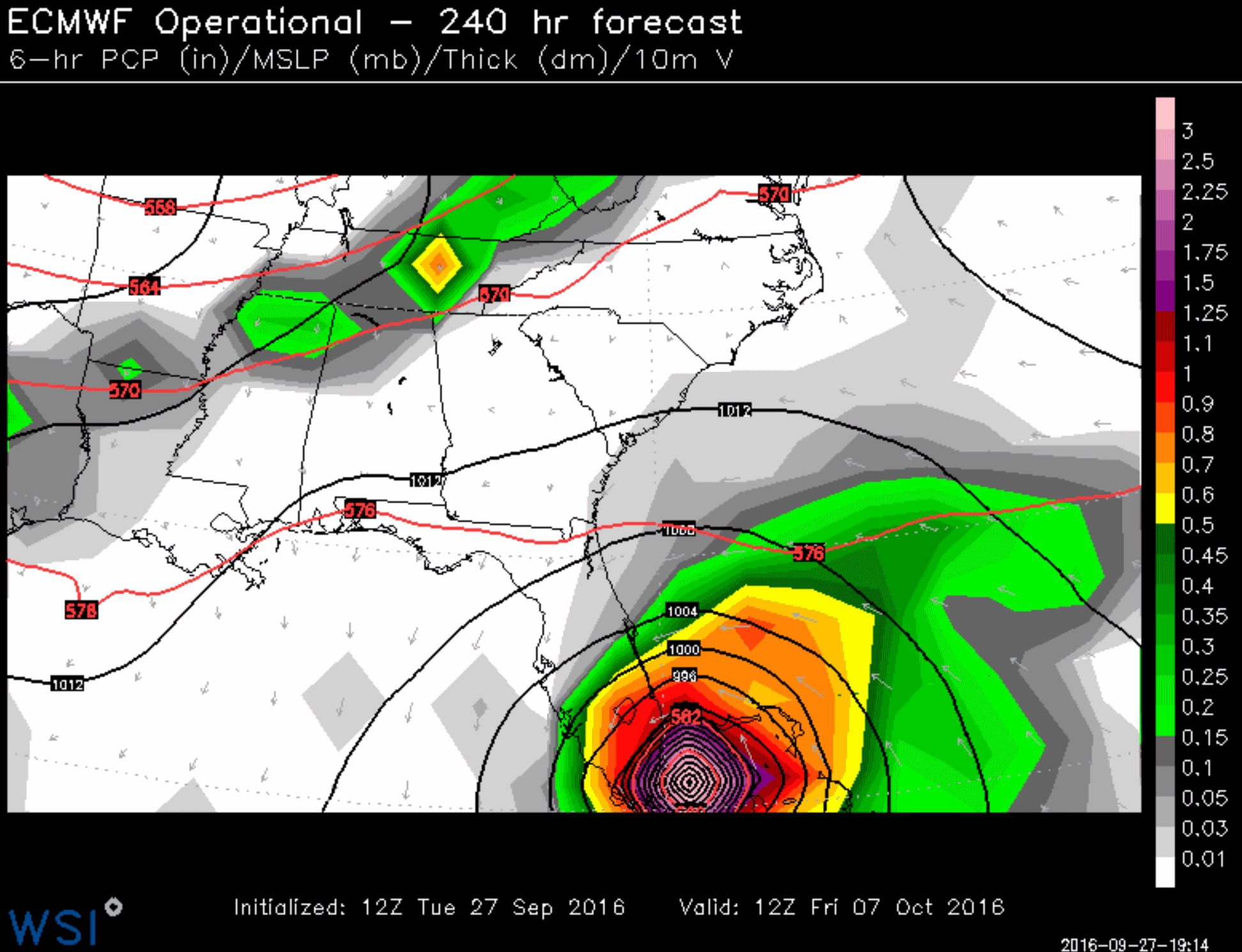
Weather Model Fantasies, Version 1.0. Here is the 12z ECMWF solution for late next week, showing a major hurricane approaching south Florida. Wouldn’t it be ironic if this verified and Big Weather became the “October Surprise”? I think the probability of a direct strike on Miami is small, but not zero. Map: WSI.
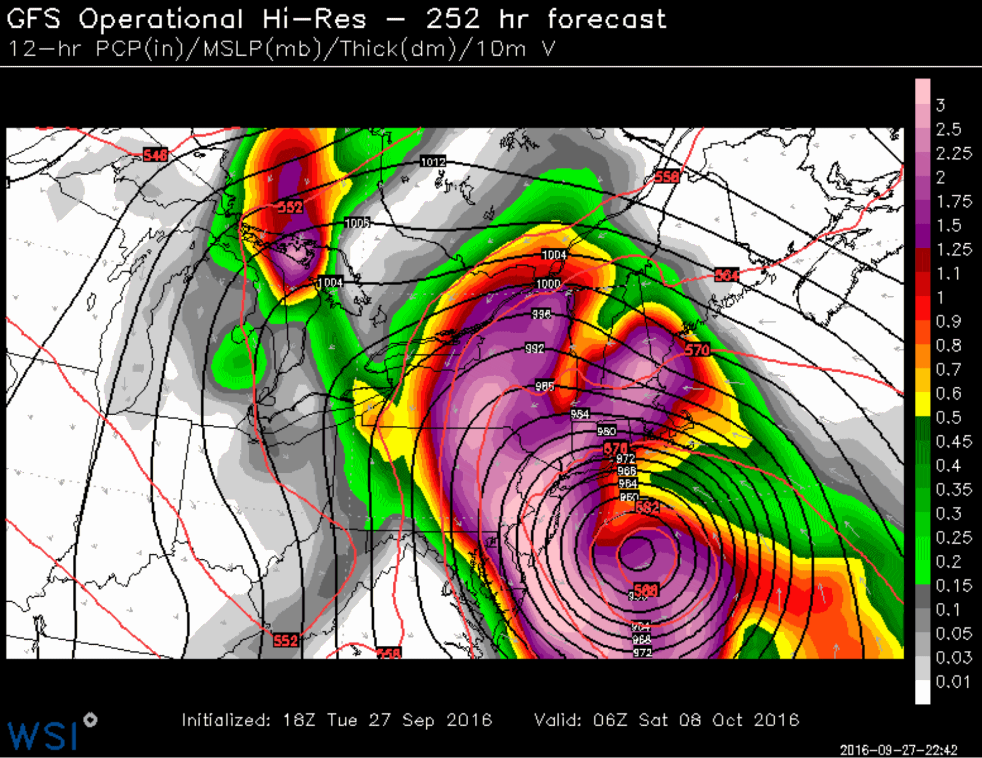
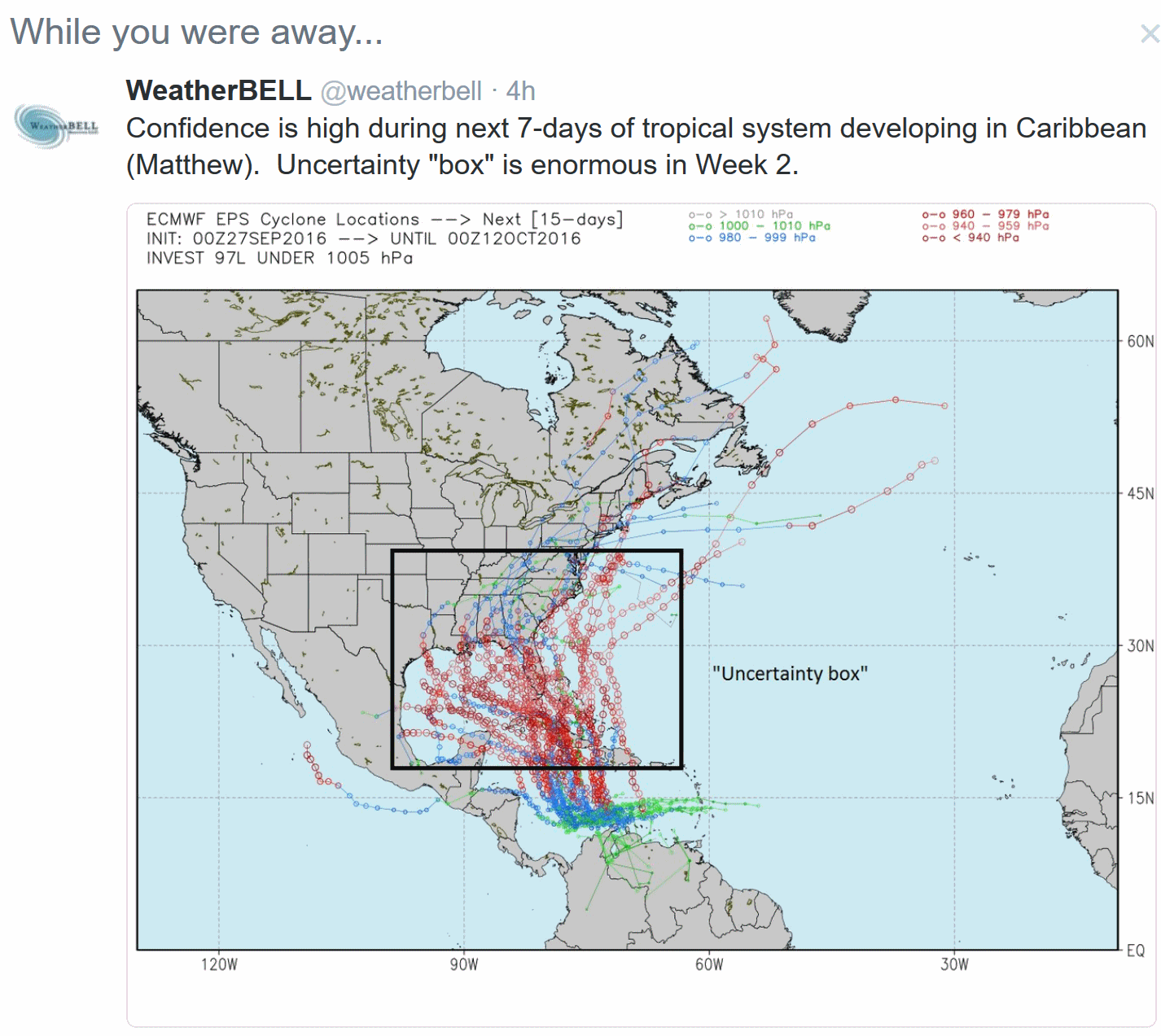
Weather Model Fantasies, Version 1.1. Not to be outdone by the European, NOAA’s GFS simulation brings a major hurricane into the Mid Atlantic and New York City area. No, I don’t believe this solution either, but I’m showing you this (now) to give you some sense of how problematic it is to look at weather models and make a credible forecast. During Sandy in 2012 the ECMWF gave about 8 days lead time that a strong tropical system would hook into New Jersey, 2-3 days more lead time than NOAA’s models. But no model is perfect; we learned that (again) with Hermine, when even the ECMWF failed. We’ll look at multiple models in the coming days to see if this is a fluke or a real trend. I wouldn’t get too excited yet.

War-Tested HESCO Barriers Protecting Iowans from Floods. I found this sidebar from the Cedar Rapids, Iowa flooding story interesting; here’s a clip from
The Des Moines Register: “
A war-zone staple has become an increasingly common sight in Iowa towns threatened by floodwaters. Hundreds of thousands of U.S. troops used HESCO barriers to protect themselves from bullets and bombs in Iraq and Afghanistan. Over the past week, similar barriers have been set up in Iowa as temporary flood walls. The barriers are giant boxes made of sturdy metal netting covered by a tough fabric. They fold up and can be stacked on pallets…”
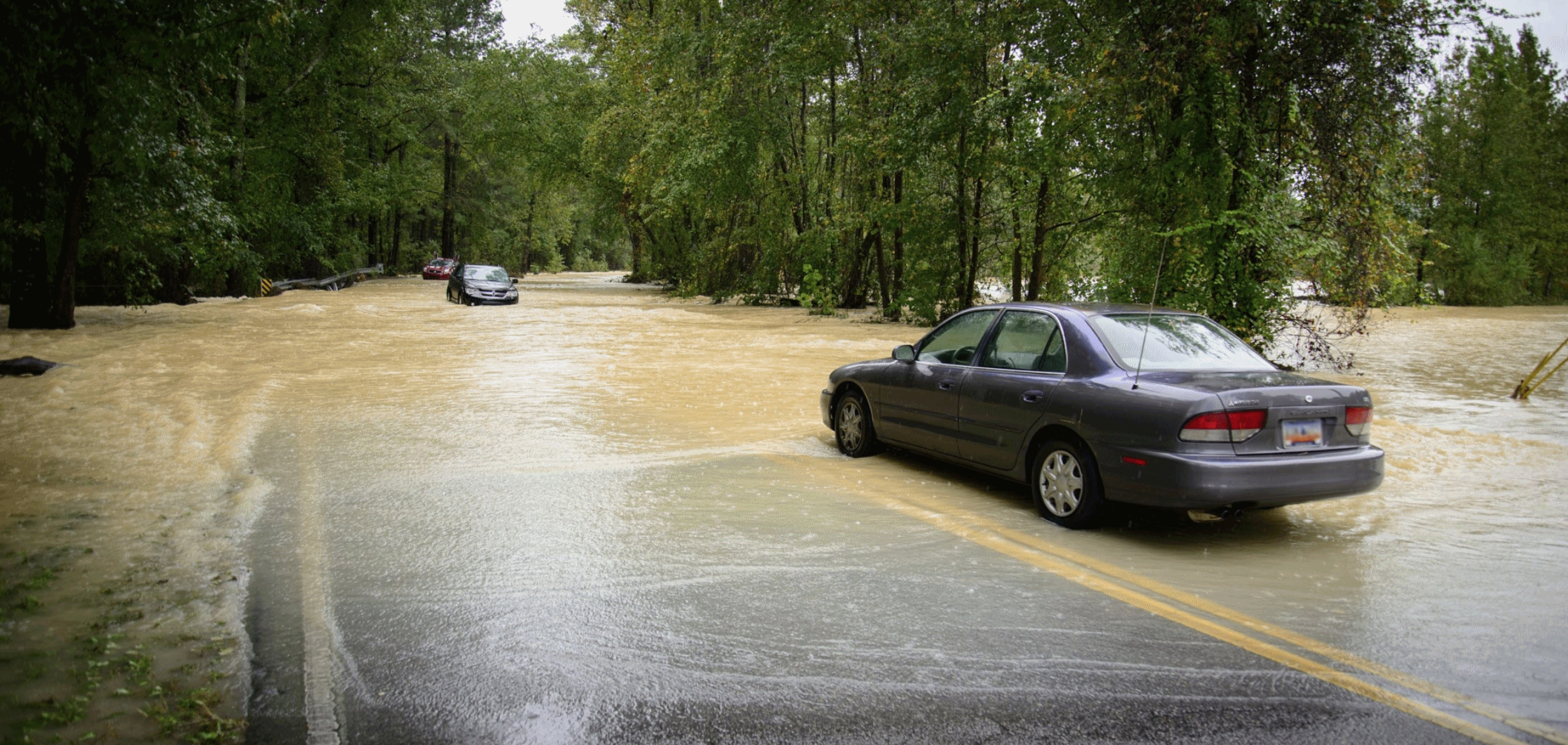
Louisiana Flood of 2016 Made Worse by Growth-Focused Policies. A warmer, wetter climate was a big factor; so was overdevelopment, according to a story at
NOLA.com in New Orleans: “
There’s nothing new about flooding in southeast Louisiana. But in the Baton Rouge area, at least, the devastation wreaked by heavy rains is getting worse. Suburban growth into areas with a history of flooding is putting more houses, businesses and lives at risk. Every new road, bridge, levee or other human-made structure further obstructs — and slows — the natural drainage patterns within the Amite River Basin, where the Amite and Comite rivers flow into Lake Pontchartrain. And long-discussed projects intended to mitigate flood damage in and around Baton Rouge remain under-funded and far from finished...” (File image: NOAA).

Weather-Wise, It Was a Summer of Extremes. Here’s an excerpt of a summary at
The Washington Post: “…
Summer featured floods that killed hundreds of people and caused more than $50 billion in losses around the globe, from Louisiana to China, India, Europe and the Sudan. Meanwhile, droughts parched croplands and wildfires burned in California, Canada and India. Toss in record heat that went on and on. From June to August, there were at least 10 weather disasters that each caused more than $1 billion in losses, according to insurance industry tallies. With summer weather now seemingly stretching from May to September, extreme weather in that span killed more than 2,000 people. And that’s without a major hurricane hitting a big U.S. city, although the Pacific had its share of deadly and costly storms. “We’ve experienced an increasing number and a disturbing number of weather extremes this summer,” U.S. National Weather Service Director Louis Uccellini said…”
Photo credit: “Danny and Alys Messenger paddle a canoe away August 16 from their flooded home in Prairieville, Louisiana. The flooding was part of a summer that saw a lot of extreme weather.” (Max Becherer/AP)
High-Tech Future Early Warning System for Hurricanes, Tornadoes and Volcanic Eruptions. Let’s see if this holds up over time, but I found an article at
phy.org potentially promising: “…
We essentially verified many of the results from a long-term study by the U.S. National Oceanic and Atmospheric Administration (NOAA) – but we substituted a ring laser in place of microphones,” said Robert Dunn, professor of physics at Hendrix College. The group’s ring laser wasa able to “clearly show the frequency spectrum of the infrasound,” he said. Specifically, they were able to detect infrasound from tornadoes 30 minutes before the tornado funnel was on the ground. The group also determined that infrasound from a tornado can travel 1,000 kilometers – which confirms earlier studies by NOAA…”
File image: Camille Seaman.
Senate Weather Bill That Supports Forecast Improvement Can Benefit All Americans. Here’s an excerpt of an Op-Ed at
Capital Weather Gang: “
Despite living in a world of intense political differences, nearly everyone can agree that timely, reliable and accurate weather information has great value. Proposed legislation in Congress would support important advances in weather prediction that would have enormous societal benefit. Sen. John Thune (R-S.D.) has sponsored a “Seasonal Forecasting Improvement Act” (S.1331), a bill that would complement the Weather Research and Forecasting Innovation Act of 2015 (H.R.1551) already passed by the House and sent to the Senate for consideration…”
“We essentially verified many of the results from a long-term study by the U.S. National Oceanic and Atmospheric Administration (NOAA)—but we substituted a ring laser in place of microphones,” said Robert Dunn, professor of physics at Hendrix College.
The group’s ring laser was able to “clearly show the frequency spectrum of the infrasound,” he said. Specifically, they were able to detect infrasound from tornadoes 30 minutes before the tornado funnel was on the ground. The group also determined that infrasound from a tornado can travel 1,000 kilometers—which confirms earlier studies by NOAA.
Read more at: http://phys.org/news/2016-09-high-tech-future-early-hurricanes-tornados.html#jCp
The Mind-Boggling New Orleans Heat Record That No One Is Talking About. Here’s an excerpt at
Capital Weather Gang: “
During one of the country’s hottest summers, New Orleans quietly set a mind-boggling record. On 43 nights, the temperature did not drop below 80 degrees in New Orleans, according to the Louisiana state climatologist. It blows the previous record out of the water — 13 nights in 2010. It’s also incredible considering in an average summer, New Orleans has just 2.1 nights at or above 80 degrees. This record should be getting much more attention than it has been…”
Photo credit: “New Orleans has set an alarming record for warm overnight lows this year.” (Joe Flood).
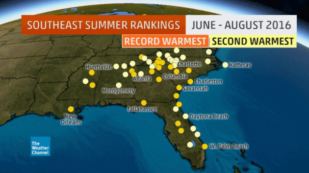
A Complete Run-Down Of All The Times Summer 2016’s Weather Turned Weird and Violent. Here’s an excerpt from Wunderblog: “…45 U.S. cities saw their hottest summers on record, according to the Southeast Regional Climate Center, and 53 additional cities barely missed their record-hottest summer. Including U.S. territories, the United States broke more than 8,800 daily hot nighttime temperature records from May to September. In addition, more than 6,300 record warm minimum temperatures were tied during that same period. Numerous cities, including Atlanta and Nashville, neared or broke records for the longest period of time spent above 70 degrees. In July, Kuwait and Iraq set new all-time temperature records for the Eastern Hemisphere; temperatures soared to a high of 129 degrees Fahrenheit...”
Map credit: The Weather Channel. “Locations with either their record hottest (orange dots) or second hottest (yellow dots) summer (June through August) on record in 2016. Locations with at least 60 years of data are shown.” (Data: Southeast Regional Climate Center).
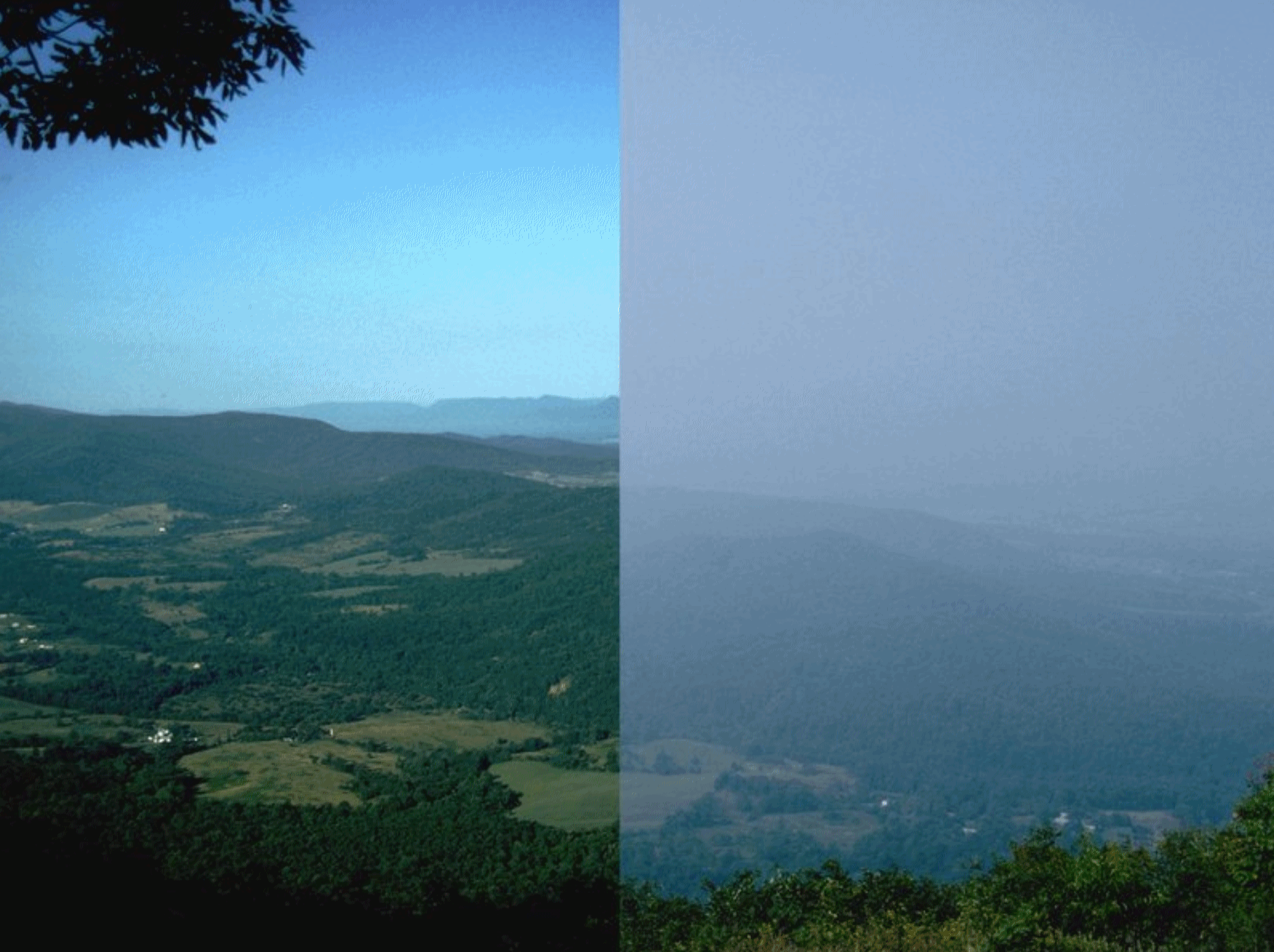
Unsafe Air Pollution Levels Affect 9 in 10 People Globally, Report Says. Here’s an excerpt from TIME: “More than 90% of the world’s population lives in areas with unsafe pollution levels, according to a new report. The research, conducted by the World Health Organization (WHO), underscores the growing risk that air pollution poses to virtually every demographic group across the globe. More than 6 million people died in 2012 from ailments related to air pollution, according to the WHO. “Air pollution continues take a toll on the health of the most vulnerable populations — women, children and the older adults,” said Flavia Bustreo, WHO assistant director general, in a statement. “For people to be healthy, they must breathe clean air from their first breath to their last…” (File image: National Park Service).

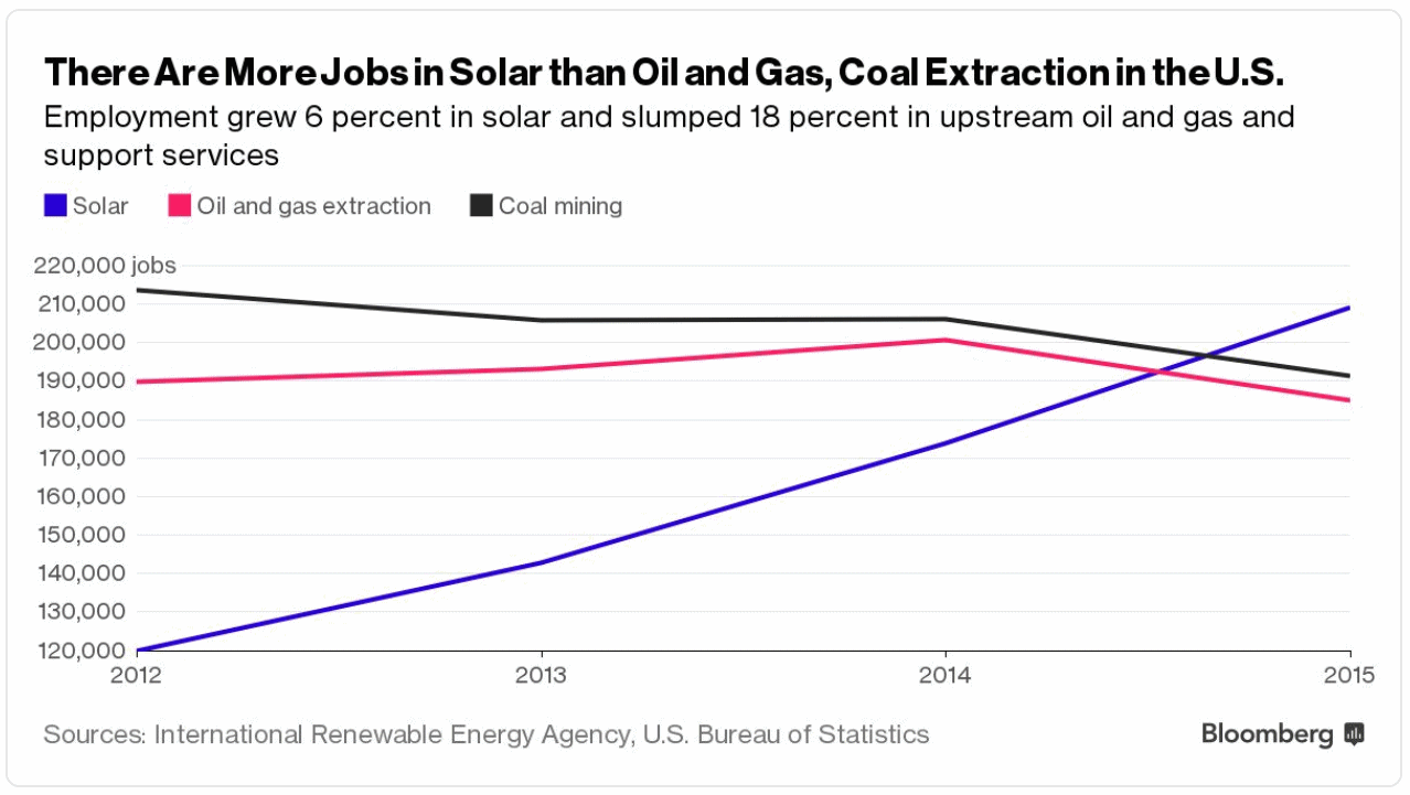
Transportation is Overtaking Electricity Generation as the Largest Source of U.S. CO2 Emissions. Here’s an excerpt from
The University of Michigan Energy Institute: “
The average rate at which CO2 is emitted from vehicle tailpipes and other mobile sources has exceeded the rate of CO2 emissions from electric power plants over seven of the past eight months. These trends indicate that transportation will overtake electricity as the nation’s largest source of CO2 emissions this year. Electric sector CO2 emissions have dropped greatly in recent years, declining at an average rate of 2.8 percent per year over 2007-2015. This reduction is due to the displacement of coal by natural gas, wind and solar for power production as well as energy efficiency gains...”

Cars Take Up Way Too Much Space in Cities. New Technology Could Change That.
Vox has an intriguing story and vision for the future of our cities – here’s an excerpt: “…
The average car, two hulking tons of steel, is 80 percent empty when it’s being driven by a single person. And most of the day, cars are totally empty, sitting unused. That, of course, requires space for parking: There are a billion parking spots across the United States, four for every car in existence. Plus, there are all the paved roads crisscrossing our cities. Add it up, and many downtowns devote 50 to 60 percent of their scarce real estate to vehicles. It all seems rather inefficient and wasteful. If cities could reclaim even a fraction of this land from vehicles, they could build more housing, or stores, or parks, or plazas…”
Image credit: “An illustration from San Francisco’s Smart City proposal. On the left are streets currently occupied by cars and street parking. By shifting to shared, autonomous vehicles, much more area could be reclaimed for parks and housing.” (SFMTA).
TODAY: Mix of clouds & sun, cool breeze. Winds: N 8-13. High: 64
WEDNESDAY NIGHT: Clearing and cool. Low: 47
THURSDAY: Bright sun, a flawless sky. Winds: NE 7-12. High: 67
FRIDAY: Lukewarm sun, still postcard-perfect. Winds: NE 7-12. Wake-up: 48. High: 71
SATURDAY: Sunny start, patchy PM clouds. Winds: NE 7-12. Wake-up: 51. High: 68
SUNDAY: Partly sunny, extra-fine fall weather. Winds: E 5-10. Wake-up: 52. High: 69
MONDAY: Milder breeze as clouds increase, showers at night. Winds: SE 10-20. Wake-up: 55: High: 73
TUESDAY: Soggy again, showers and heavy T-storms. Winds: S 10-20. Wake-up: 61. High: 68
Climate Stories….
Climate Change is Here: Inside the Summer of Hell and High Water. Here’s an excerpt from
Rolling Stone: “…
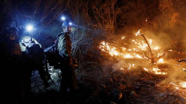
As California was gripped by fire, the hottest August in recorded history unleashed extreme weather events in every corner of the United States. Hawaii braced for an unprecedented “double hurricane,” back-to-back systems that barreled down on the Big Island before passing just offshore. Then Hermine, the first hurricane to hit the Florida capital of Tallahassee since 1985, sent tropical-storm warnings north into New England. In Louisiana, an unnamed superstorm – a windless hurricane – dumped up to 30 inches of rain, killing at least 13 people and inundating more than 60,000 homes in dozens of parishes. A “weather autopsy” led by scientists at the National Oceanic and Atmospheric Administration linked the superstorm to climate change...”
Photo credit: “Firefighters build a fire line during the Blue Cut Fire in California’s San Bernardino County in August.” Patrick T. Fallon/Zuma.
Global Warming is Real, but 13 Degrees? Not So Fast. NatGeo has details: “New research suggesting that the planet might already be committed to vastly greater warming than previously thought is being dismissed as deeply flawed by prominent climate scientists. A study published today in one of the world’s top science journals, Nature, offers the most complete reconstruction to date of global sea-surface temperatures for the past two million years—a valuable addition to the climate record, scientists say. But the conclusions the study’s author drew from that research—that even preventing any further increase of greenhouse gases in the atmosphere could still leave the Earth doomed to a catastrophic temperature rise of up to 7 degrees Celsius (about 13 degrees Fahrenheit)—isn’t supported by the data, several top scientists said...”
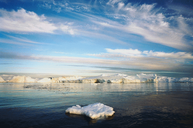
Photo credit: “Greenland is among the regions of the Earth that are experiencing the most rapid changes from global warming. If a new study is correct, all of the planet’s ice could melt in the coming centuries.” Photograph by Diane Cook and Len Jenshel, National Geographic Creative.
Teaching Middle Schoolers Climate Change Without Terrifying Them.
NPR reports: “…
So, Vazquez says the next day in class she resolved to do more. The school where she teaches, George Washington Carver Middle School, sits just eight feet above sea level; several of the surrounding neighborhoods are even lower. She thought, by the time her students were adults with families of their own, storm surges could bring waves lapping at their front doors. “If we just despair, it leads to inactivity. So I thought, ‘If they’re doing positive things, it will be helpful,’ ” she says.
And positive things they’re doing…”
Image credit: LA Johnson/NPR.