Tiptoeing Into Winter
The view from Golden Eagle Lodge in the Boundary Waters Canoe Area on Sunday showed a very wintry scene in the area. Note that the average temperatures in International Falls is running nearly 12.5F below average through the first half of the month, while the Twin Cities is running nearly 8.5F below average for the month so far.
Ice Safety
Ice is starting to form on area lakes and ponds, but we’re far from the ice being safe out there! Here’s an excerpt from the MN DNR regarding ice safety. Note that ICE IS NEVER 100% SAFE, but in order to walk out safely onto the ice, you need 4″ of ice!
There really is no sure answer. You can’t judge the strength of ice just by its appearance, age, thickness, temperature, or whether or not the ice is covered with snow. Strength is based on all these factors — plus the depth of water under the ice, size of the water body, water chemistry and currents, the distribution of the load on the ice, and local climatic conditions.
Snow Depth 2017 vs 2016
Here’s the estimate snow depth from NOAA’s NOHRSC, which shows how much more snow there is this year compared to last. Thanks to cooler than average temps this month, snow has been more prevalent. Last November, temps were nearly 10.5F above average for the month!
Missed By A Midweek Storm
Here’s the forecast through PM Wednesday, which shows quiet weather on Monday, but late Tuesday into Wednesday, a much larger storm system develops over the Great Lakes. This storm will bring widespread rain to areas in the Great Lakes with a little snow across the far north.

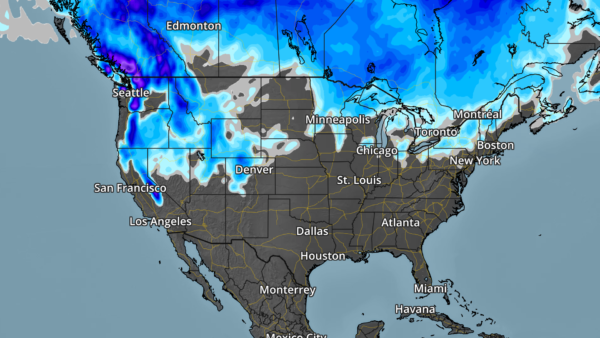
Snowfall Potential Through the Week

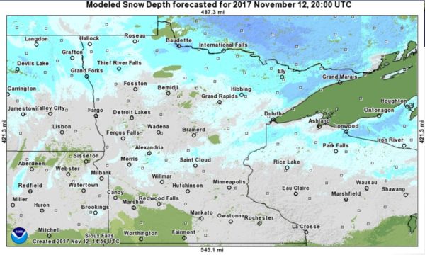
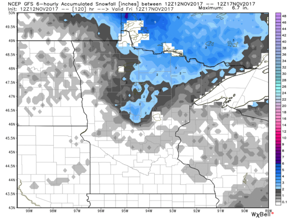
Here’s the snowfall potential through Friday morning, which suggests minimal snowfall potential through the second full week of November. The best potential of any accumulation looks to be in far northern MN, where 2″ or 3″ maybe possible.

_________________________________________________________________
September 10th – Official Peak of the Atlantic Hurricane Season

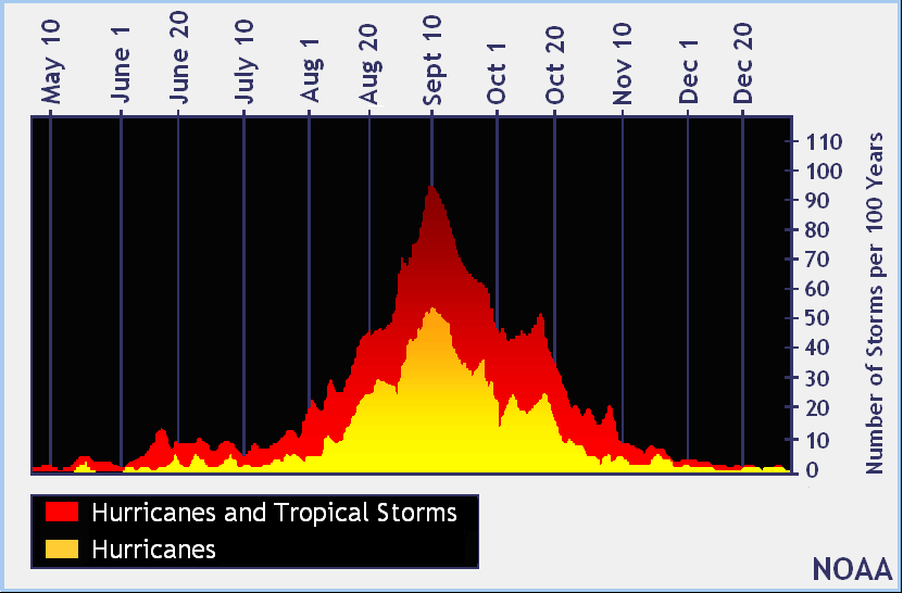
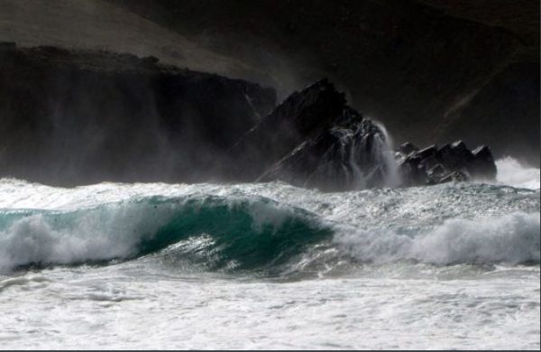
We are a little more than 2 weeks from the official close of the Atlantic Hurricane Season (November 30th). Note that peak activity generally occurs on September 10th and stays somewhat active through the month of October, but really diminishes through the month of November. With that said, there have been years where tropical activity continues through the end of the year and even into the follow calendar year! 2005 was one of those years as Tropical Storm Zeta developed December 30th and continued through January 6th, 2006.


___________________________________________________________

Ongoing Large Wildfires

Here’s a look at the current wildfire map across the country. Note that wildfire activity as REALLY slowed down with only a few major wildfires still burning across parts of Washington, Texas and New Mexico.f

Here’s a list of all the current large wildfires from Inciweb:

_________________________________________________________
PRELIMINARY 2017 Tornado Map

It certainly has been a fairly active first half of 2017 with 1,471 preliminary tornado reports through October 31st. Note that this is the most tornadoes through that date since 2011, when there were 1,820 reports. The map below shows the distribution of the tornadoes so far this year.

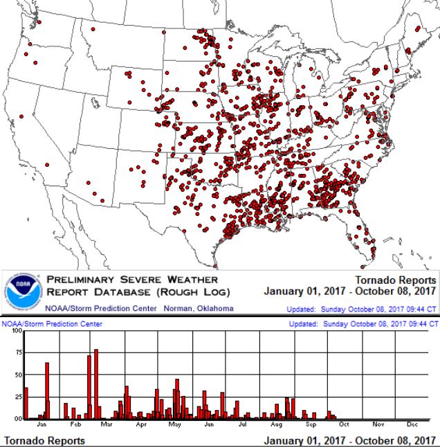
PRELIMINARY 2017 Tornado Count

According to NOAA’s SPC, the PRELIMINARY 2017 tornado count is 1,490 (through November 11th). Note that is the most active year for tornadoes since 2011, when there were 1,845 tornadoes. Keep in mind there was a major tornado outbreak in the Gulf Coast region from April 25-28, 2011 that spawned nearly 500 tornadoes, some of which were deadly. That outbreak is known as the Super Outbreak of 2011 and has gone down in history as one of the biggest, costliest and one of the deadliest tornado outbreaks in history.


_____________________________________________________________________

National Weather Hazards Ahead…

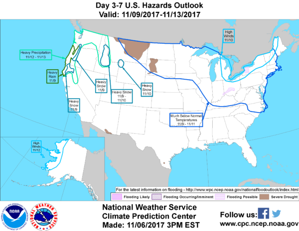
1.) Heavy precipitation across portions of California, Oregon, Washington, and northern Idaho, Mon-Fri, Nov 13-17.
2.) High winds across coastal portions of California and the Pacific Northwest, Mon-Tue, Nov 13-14.
3.) High winds across portions of the Great Basin, Mon, Nov 13.
4.) Heavy snow across portions of the Bitterroots, Wed-Fri, Nov 15-17.
4.) Heavy snow across portions of the Tetons, Wed, Nov 15.
5.) Heavy snow across portions of the western Great Lakes and the Upper Mississippi Valley, Thu-Fri, Nov 16-17.
6.) High winds across much of the Rockies, Great Plains, Upper and Middle Mississippi Valley, and Great Lakes, Thu-Fri, Nov 16-17.
7.) Much below normal temperatures across portions of the Alaska Panhandle and southeastern Alaska, Wed-Fri, Nov 15-17.
8.) High winds across downslope areas of the Alaska Panhandle and southeastern Alaska, Wed-Fri, Nov 15-17.
9.) Heavy precipitation across portions of California, Oregon, and Washington, Sat-Sun, Nov 18-19.
10.) Heavy snow across portions of the Bitterroots, Sat-Sun, Nov 18-19.
11.) Slight risk of much below-normal temperatures for portions of the Great Lakes, Northeast, the Appalachians, the Tennessee and Ohio Valley, the Mid-Atlantic, the Southeast, and the Great Lakes, Wed-Fri, Nov 22-24.
12.) Moderate risk of much below-normal temperatures for portions of the Alaska Panhandle, Sat, Nov 18.
13.) Slight risk of much below-normal temperatures for portions of the Alaska Panhandle and mainland Alaska, Sat-Wed, Nov 18-22.
14.) Severe Drought across parts of the the Lower and Middle Mississippi Valley, the Northern and Southern Plains, the Northern Rockies, Arizona, and Hawaii.

_____________________________________________________________________

High Temps Monday

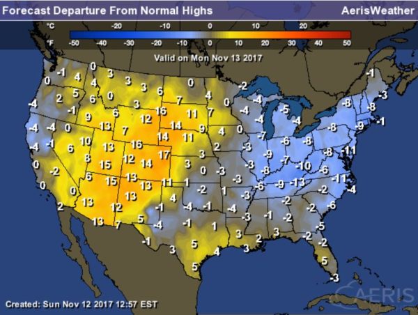
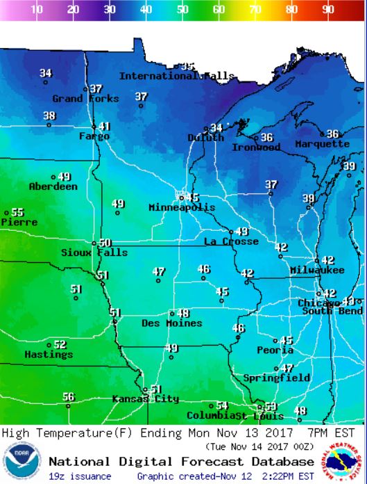
Here’s a look at high temperatures across the nation on Monday, which suggests that temperatures across the eastern part of the nation will still be running below average. However, folks in the Four-Corners Region to the Plains will be nearly 10F to 15F above average.


National Weather Outlook

Here’s the weather outlook through Tuesday, which shows active weather continuing across parts of the Eastern US and the Pacific Northwest. Part of that system will turn into a developing storm a in the middle part of the country.

7 Day Precipitation Outlook

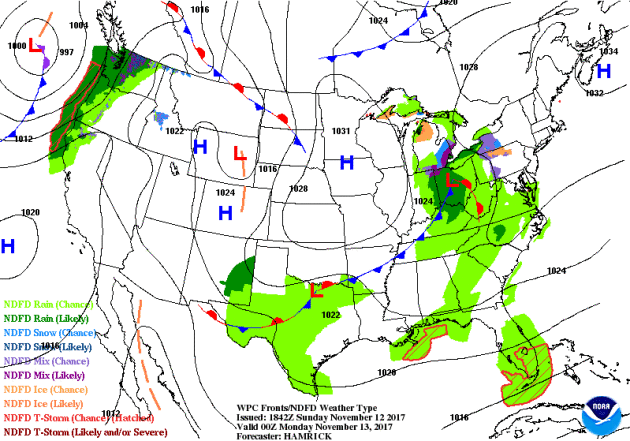
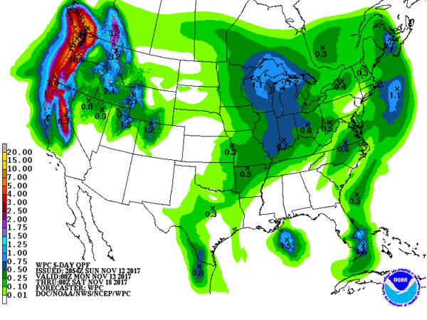
According to NOAA’s WPC, areas of heaviest precipitation will be found across the Western US with double digit liquid tallies possible across the high elevations in the Cascades and the Olympic Mountains. There will also be some 1″ to 3″ liquid tallies across the Central and Northern Rockies.

Snowfall Potential
Here’s the snowfall potential over the next 5 days, which shows the heaviest snow falling across the high elevations in the Western US. There will also be some light accumulations across the northern tier of the nation.
________________________________________________________________________
Giving Thanks for a Couple of Quiet Weeks
By Paul Douglas
You’ve heard of Murphy’s Law? Of course you have! It turns out Murphy was a part-time meteorologist, forced to predict the weather, against his will. I read this on the Internet so it must be true. Murphy’s little known 4th Corollary states that “Storms, given a choice, prefer to come on weekends and major holidays.”
Is there science to support this? No. It’s just that we’re all more “weather-aware” on weekends and holidays. When foul weather gums up our plans we’re more likely to make a mental note.
After the coldest start to a November since 1995 (55.5 inches of snow fell later that winter) our weather looks fairly quiet the next 1-2 weeks; no major wrinkles in the jet stream capable of whipping up a major storm. “This isn’t so bad!” Only in Minnesota. 40s today and low 50s on Tuesday will feel almost reasonable, after last week’s early-season chill. Friday rain ends as a few flurries early Saturday. By the time it’s cold enough for snow most of the moisture will be east of town.
Long-range models hint at 40s and quiet on Thanksgiving; maybe a few more 50s late November.
________________________________________________________________________
Extended Forecast
 MONDAY: Peeks of sun, grilling weather. Winds: S 10-15. High: 48.
MONDAY NIGHT: Mostly cloudy. Light drizzle possible. Winds: SSE 5-10. Low: 37.
TUESDAY: Patchy cloud and milder. Winds: SE 10-15. High: 44.
WEDNESDAY: Mostly cloudy, drying out. Winds: NW 10-15. Wake-up: 35. High: 40:
THURSDAY: Sunny start, then increasing clouds. Winds: SE 5-10. Wake-up: 27. High: 40
FRIDAY: Rain developing, wet roads. Winds: S 7-12. Wake-up: 37. High: 46.
SATURDAY: Flurries taper, windy and colder. Winds: NW 10-20. Wake-up: 30. High: 33.
SUNDAY: A sunnier, nicer day with less wind. Winds: NW 5-10: Wake-up: 18. High: 34.
_______________________________________________________

This Day in Weather History
November 13th

1986: Lakes are frozen over throughout much of the state, reaching as far south as Winona.

1938: A snowstorm develops across northern Minnesota. The barometer falls to 29.31 inches in Duluth.

1933: The first Great Dust Bowl Storm occurs. The sky darkened from Minnesota and Wisconsin to New York State.
________________________________________________________

Average High/Low for Minneapolis
November 13th

Average High: 43F (Record: 71F set in 1999)
Average Low: 28F (Record: 0F set in 1986)

Record Rainfall: 1.04″ set in 1951
Record Snowfall: 7.7″ set in 2010
_________________________________________________________

Sunrise/Sunset Times for Minneapolis
November 13th

Sunrise: 7:08am
Sunset: 4:46pm

Hours of Daylight: ~9 hours 38 mins

Daylight LOST since yesterday: ~2 minutes and 25 seconds
Daylight LOST since summer solstice (June 20th): 5 hours & 59 minutes
__________________________________________________________

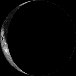
Moon Phase for November 7th at Midnight
3.4 Days After Last Quarter


_________________________

 Weather Outlook For Monday

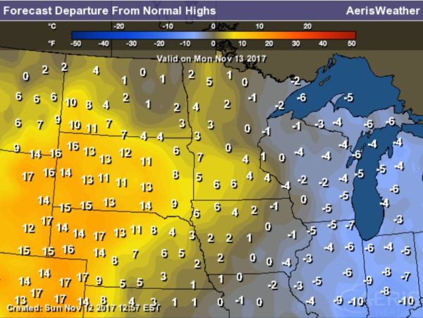
Tuesday will be another chilly day across the region with temps running nearly 10F to 15F below average. Much of the state will only see highs in the 20s and 30s across Minnesota and the northern half of Wisconsin.

__________________________________________________________________________
Minneapolis Temperature Outlook

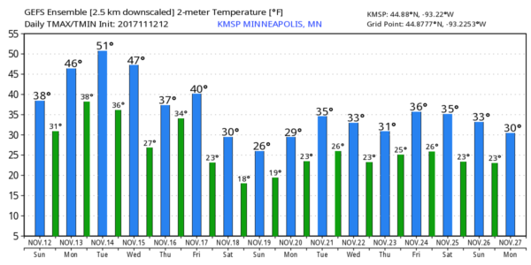
Here’s the temperature outlook through November 27th, which shows a very mild week ahead with temps approaching 50F or better a few times through Wednesday. Considering how chilly it’s been as of late, this will feel like a November heatwave! Note that temps take a dip later this week and weekend ahead with 30s likely into the 2nd half of the month.

_________________________________________________________________

6 to 10 Day Temperature Outlook

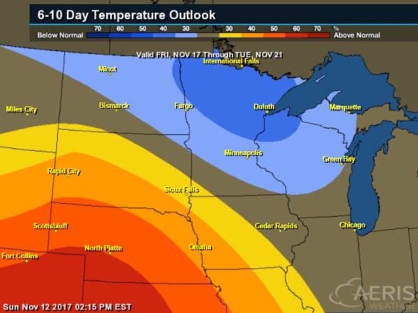
Temps may warm up a bit as we head through the 2nd full week of November, but the extended outlook suggests that cooler than average temperatures will return from November 17th to the 21st.

6 to 10 Day Temperature Outlook

According to NOAA’s CPC – much of the southwestern part of the nation will remain much above average, but areas from the Midwest and into the Mid-Atlantic will be cooler than average as we head into the 2nd half of the month.


_____________________________________________________________________

“Why You Really Shouldn’t Eat Yellow Snow”
“Yellow snow is the topic of many a winter joke. Since snow in it’s purest form is white, yellow snow is said to be colored with yellow liquids, like animal urine. But while animal (and human) markings can indeed turn snow yellow, these aren’t the only cause of yellow snow. Pollen and air pollution can also lead to large areas of snow cover that looks like lemonade. Here are the ways snow can acquire a golden hue.”
______________________________________________________________________
“The Long Legacy of Ireland’s ‘Night of the Big Wind’”
IN OCTOBER OF 2017, HURRICANE Ophelia hit Ireland, knocking out power to thousands of residents and killing at least three people. The storm caused serious damage, but it was far from the first time the island has weathered catastrophic winds. In 1839, a massive storm raged across Ireland, causing unprecedented destruction. Called “Oíche na Gaoithe Móire” in Irish, The Night of the Big Wind took place on Sunday, January 6, 1839, hitting the country with little warning. By the time the tempest had finished cutting a destructive swath across the Emerald Isle, it had also left a mark on the national psyche that can still be felt today. The night before the day of the storm, snow had fallen, and the skies were still filled with slaty clouds that morning. By midday, rain had begun to fall in parts of the country, and as the afternoon went on, temperatures began to rise, bringing an unseasonable warmth. While some scholars had begun to record climate information by the late 1830s, weather forecasting was still more guess work than science, and the odd warmth did not portend what was brewing off the Western coast of the country.”
_________________________________________________________
“Users Report iPhone X Display Becomes Unresponsive in Cold Weather”
“The weather is getting colder in many parts of the world. And according to a handful of social media reports, the chillier temperatures are having an adverse effect on Apple’s new iPhone X. Reportedly, the iPhone X’s OLED display becomes much less responsive to touch when the device is being used in cold weather. One Redditor who experienced the problem wrote that it “literally takes 2 seconds” when moving from indoor temperature to outdoor temperature for the issue to take place. “I try swiping on websites and it doesn’t register my finger. It’s very noticeable,” the user, darus214, wrote in a Reddit post on Wednesday.”
______________________________________________________________________________
“Weather and climate disasters on the rise”
This year has been the most disastrous weather and climate year on record – and it’s not even over yet. The California Department of Insurance just announced that losses incurred from the October wildfires exceeds 3 billion dollars, and is expected to rise even further. That has now become the sixteenth billion-dollar disaster in the United States this year, tying the 16 from 2011.  The National Centers for Environmental Information (NCEI) says that these billion-dollar disasters are on the rise.  Mother Nature has cost Americans more than a trillion dollars since 1980 according to the NCEI database, that lists all the country’s billion-dollar disasters since 1980, including tropical cyclones, severe weather, floods, droughts, freezes, wildfires, and winter storms. Colorado is no stranger to billion-dollar disasters. In May of this year, a severe storm dropped baseball size hail across the Denver metro area causing $1.5 billion in damage. The total damage across five states was $2.2 billion.”

___________________________________________________________________________
“How can we save America’s vanishing beaches? California shows the way, according to report”
Shorelines are shrinking. Storms are flooding streets and battering homes. Coastlines around the country are being hit by climate change. And, perhaps surprisingly, California is offering an example of how the coast can be saved. So says the latest annual State of the Beach Report Card released Tuesday by the Surfrider Foundation. The report grades 30 states and Puerto Rico on policies that address coastal erosion, sea level rise and extreme weather events. The San Clemente-based nonprofit has compiled the report annually since 2000. While California earned high marks in most categories — and was the only state to receive an “A” — the results show that most coastal states are losing the battle with climate change, and that all states need to make improvements if they want to keep their coasts. “Our beaches are disappearing at alarming rates, and our report shows that the majority of states do not have strong policies in place to protect our coasts, or worse, have loopholes that actually prevent it,” said Dr. Chad Nelsen, Surfrider’s chief executive, in a prepared release.
___________________________________________________________________________
“Is daylight saving time worth the trouble?”
Today the sun is shining during my commute home from work. But this weekend, public service announcements will remind us to “fall back,” ending daylight saving time by setting our clocks an hour earlier on Sunday, November 5. On November 6, many of us will commute home in the dark. This semiannual ritual shifts our rhythms and temporarily makes us groggy at times when we normally feel alert. Moreover, many Americans are confused about why we spring forward in March and fall back in November, and whether it is worth the trouble. The practice of resetting clocks is not designed for farmers, whose plows follow the sun regardless of what time clocks say it is. And it does not create extra daylight – it simply shifts when the sun rises and sets relative to society’s regular schedule and routines. The key question is how people respond to this enforced shift. Most people have to be at work at a certain time – say, 8:30 a.m. – and if that time comes an hour earlier, they simply get up an hour earlier. The effect on society is another question. Here, the research shows that daylight saving time is more burden than boon.”
Thanks for checking in and don’t forget to follow me on Twitter @TNelsonWX