
_________________________________________________________________________
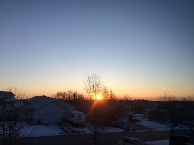
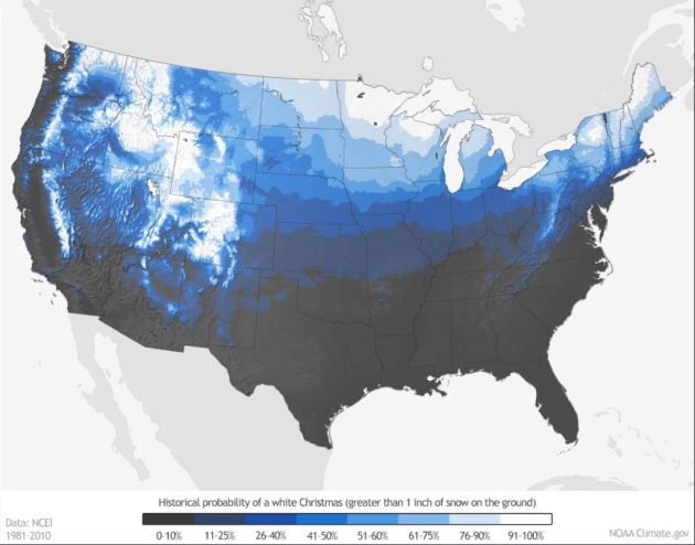
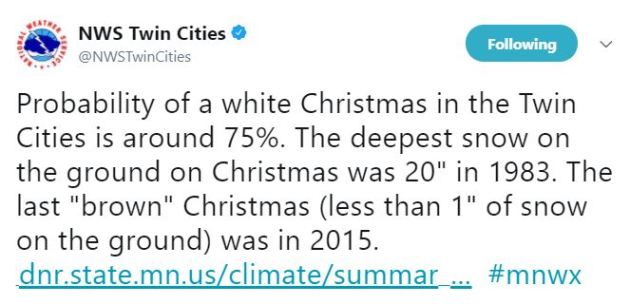
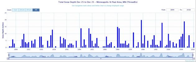
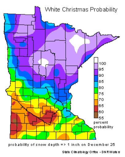
Probability of a White Christmas?
____________________________________________________________________________
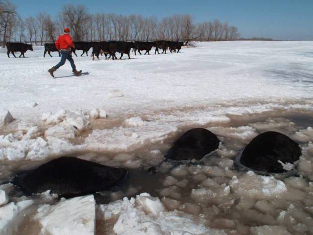
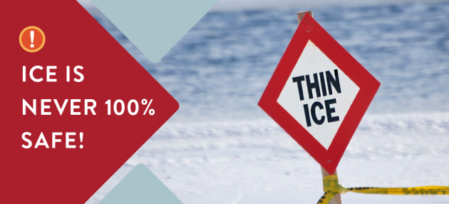
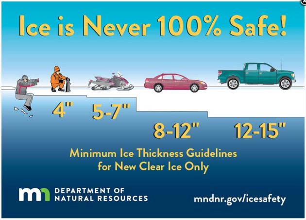
Under 4″ – STAY OFF
4″ – Ice fishing or other activities on foot
5″ – 7″ – Snowmobile or ATV
8″ – 12″ – Car or small pickup
12″ – 15″ – Medium truck
Many factors other than thickness can cause ice to be unsafe.
White ice or “snow ice” is only about half as strong as new clear ice. Double the above thickness guidelines when traveling on white ice.
_________________________________________________________________________
Weather Outlook Ahead
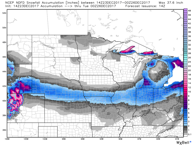
Here’s the weather outlook from Sunday to Tuesday, which shows fairly quiet weather happening close to home through Christmas day. Good news for travelers locally, but for those headed southeast near Chicago and the surrounding states, a fast moving storm system could bring a fesh coasting of snow that may hamper traveling there.
.gif)
___________________________________________________________________
.png)
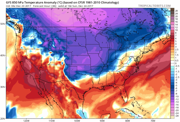
Arctic Air MassArrives
High Temps Sunday
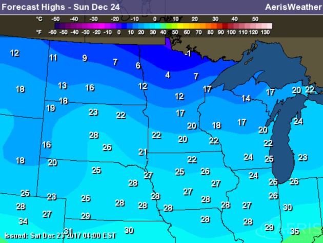
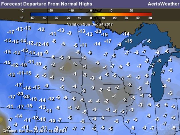
High temperatures on Sunday will still be VERY chilly across much of the country with temperatures running nearly 10F to 15F below average. Meanwhile, warmer than average temperatures will continue in the southwestern and southeastern part of the country.
.gif)
According to NOAA’s WPC, the 5 day precipitation outlook suggests areas of heavier precipitation continuing across the Northeastern part of the country through midweek. There will also be heavier precipitation across the Gulf Coast States and across the higher elevations in the Rockies and Cascade ranges.
.gif)
__________________________________________________________________________
 ___________________________________________________________________________
It certainly has been a fairly active first half of 2017 with 1,521 preliminary tornado reports through December 22nd. Note that this is the most tornadoes through that date since 2011, when there were 1,897 reports. The map below shows the distribution of the tornadoes so far this year.
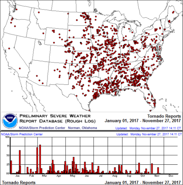
PRELIMINARY 2017 Tornado Count
According to NOAA’s SPC, the PRELIMINARY 2017 tornado count is 1,521 (through December 22nd). Note that is the most active year for tornadoes since 2011, when there were 1,897 tornadoes. Notice that the only other year with more tornadoes than this year was in 2008, which ended with a whopping 2,140 tornadoes nationwide.
.png)
_____________________________________________________________________
National Weather Hazards Ahead…
1.) High winds for coastal sections of the Mid-Atlantic and Northeast, Mon-Tue, Dec 25-26.
2.) Heavy snow for parts of the southern and central Appalachians, Mid-Atlantic, and Northeast, Fri, Dec 29.
3.) Heavy precipitation for parts of the Mid-Atlantic, Fri, Dec 29.
4.) Frozen precipitation for parts of the central Appalachians, Mid-Atlantic, and Northeast, Sat, Dec 30.
5.) Much below-normal temperatures spreading eastward across much of the northern tier of the CONUS and parts of the central Plains, Mon-Fri, Dec 25-29.
7.) Much above-normal temperatures for western and northern mainland Alaska, Mon-Tue, Dec 25-26.
Slight risk of much below-normal temperatures for much of the central and eastern CONUS, Sat-Thu, Dec 30-Jan 4 2018.
8.) Moderate risk of much below-normal temperatures for much of the north-central and northeastern CONUS, and parts of the Ohio and Tennessee Valleys, Appalachians, Mid-Atlantic, and southeast, Sat-Mon, Dec 30-Jan 1 2018.
9.) Slight risk of heavy precipitation for parts of the southeast, Wed-Fri, Jan 3-5 2018.
Flooding possible for parts of the Ohio and Tennessee Valleys.
10.) Severe drought (D2 or worse) is indicated over the Middle/Lower Mississippi Valley, southern Great Plains, northern Great Plains, Arizona, Utah and Hawaii.
.png)
_____________________________________________________________________
If Anyone Asks Minnesota Enjoys a “Dry Cold”
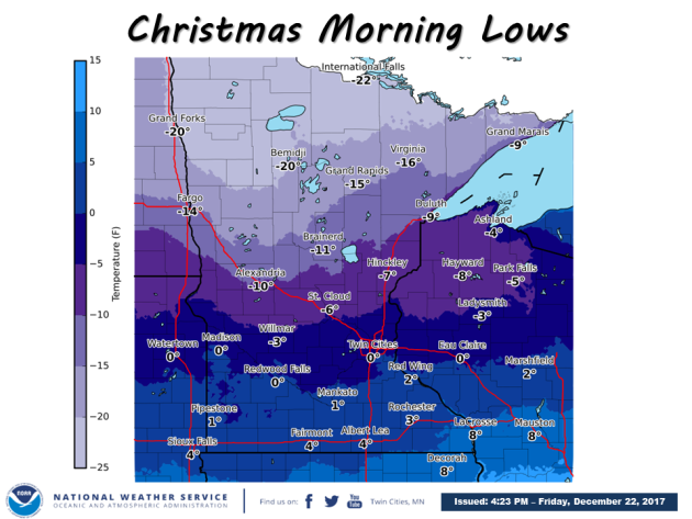
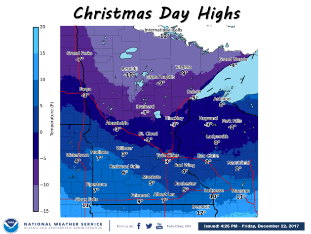
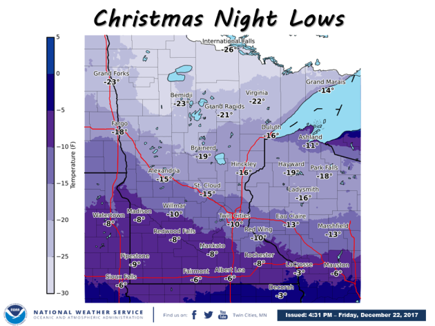
By Paul Douglas
As we ponder our big Christmas present, shipped airmail from The Yukon Territories, this might be a good time to talk about a meteorological trade-off, one that’s helped me tolerate the chill over the years.
Our coldest days tend to be sunny. Frigid Canadian air is also very dry, increasing the odds of blue sky. “Numb, with a risk of sunglasses”. Maybe I’m rationalizing here, but it helps.
You see, Minnesota enjoys a “dry cold”. Take that Phoenix. The coldest I’ve ever been is walking the Miracle Mile in Chicago, with 5F, a 40 mph wind and a humidity of 90 percent. Freezing feels much worse in cities close to (big) lakes or oceans; a high humidity means the cold cuts right through you.
Enjoy teens today; a reinforcing clipper pulls arctic air into town Christmas Day; a coating of fluff possible. The mercury may not climb much above 0F Tuesday with a windchill that may leave you daydreaming of the Caribbean. Light snow late next week may accumulate a couple inches. We’re due. And 2018 starts with some negative numbers. Models hint at moderation the second week of January.
________________________________________________________________________
Extended Forecast
SUNDAY: Some sun. Flurries late. Winds: W 7-12. Wake-up: 8. High: 20.
SUNDAY NIGHT: Mostly cloudy with a few flurries. Winds: W 5-10. Low: 0. Feels like: -10F
MONDAY: Dusting of flurries.Feels like -20F. Gusty winds. Winds: NW 10-15. High: 7.
TUESDAY: Numb. At least the sun is out. Winds: NW 10-15. Wake-up: -10. High: 1.
WEDNESDAY: Nippy sun. Fading sun. Winds: SE 5-10. Wake-up: -9. High: 7.
THURSDAY: Light snow. Light accumulation? Winds: SE 7-12. Wake-up: 2. High: 14.
FRIDAY: More light snow. Roads may be icy. Winds: S 5-10. Wake-up: 4. High: 13.
SATURDAY: Another scoop of Arctic delight. Winds: NW 10-15. Wake-up: -2. High: 4
_______________________________________________________
This Day in Weather History
December 24th
1996: Strong winds of 20 to 30 mph, combined with over a foot of new snowfall, result in restricted visibilities from blowing snow. As a result, several highways closed, including highway 19 west of Redwood Falls, highways 7 and 40 at Madison, and highways 67 and 23 out of Granite Falls.
1982: Heavy rain falls over the state, along with slushy snow over southwest Minnesota. Twin Cities gets 2.61 inches of precipitation through Christmas. Some lightning and thunder occur with the heavy rain on Christmas Eve.
_______________________________________________________
Average High/Low for Minneapolis
December 24th
Average High: 25F (Record: 46F set in 1957)
Average Low: 10F (Record: -31F set in 1872)
Record Rainfall: 1.26″ set in 1982
Record Snowfall: 5.2″ set in 2009
_________________________________________________________
Sunrise/Sunset Times for Minneapolis
December 24th
Sunrise: 7:49am
Sunset: 4:36pm
Hours of Daylight: ~8 hours 47 mins
Daylight GAINED since yesterday: ~12 seconds
Daylight GAINED since winter solstice (December 21st): 1 minute
__________________________________________________________
Moon Phase for December 24th at Midnight
1.1 Day Before First Quarter Moon
.gif)
_________________________
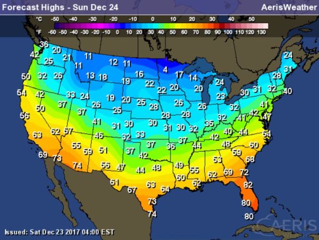
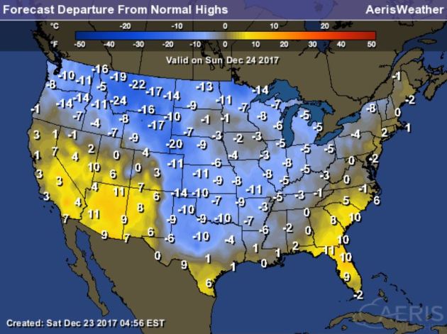
High temps on Sunday will be quite chilly across much of the region with readings nearly -5F to -20F below average! Some locations across the far northern reaches of Minnesota may not even make it above 0F for daytime highs.
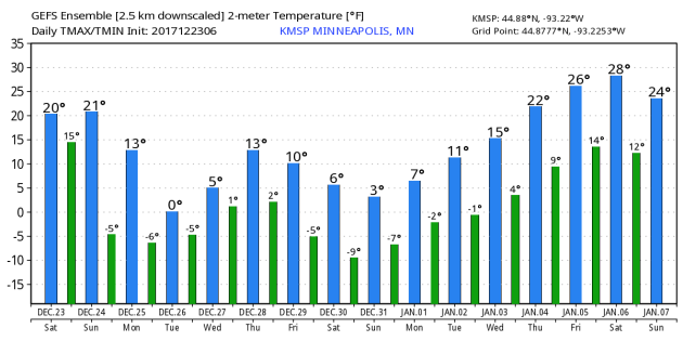
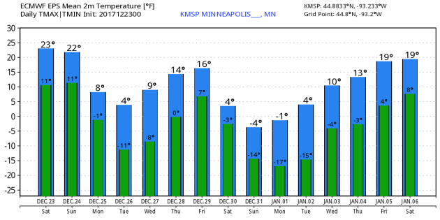
Here’s the temperature outlook from the GEFS & ECMWF modles through January 6th/7th. Both models show considerable cold sticking with us through much of the end of the month. The first few days of 2018 could be quite cold still, but the extended forecast is suggesting a warming trend by the first full weekend of 2018.
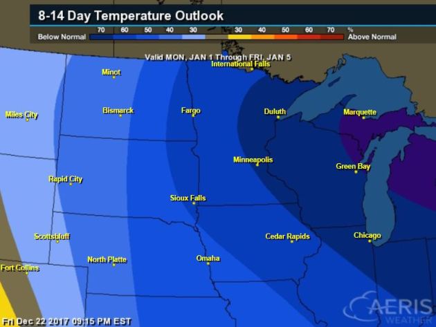
8 to 14 Day Temperature Outlook
Here’s the temperature outlook through the 1st week of January, which suggests MUCH colder than average temperatures sticking around much of the Midwest and Great Lakes through the time period. With winter officially here, it looks like winter-like will be present.
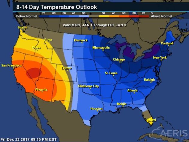
8 to 14 Day Temperature Outlook
Here’s the extended temperature outlook as we head through the 1st week of January. Note that colder than average temperatures look to stick around through much of the eastern two-thirds of the nation, while warmer than average weather will be found in the Western US.
___________________________________________________________________________
____________________________________________________________________________

____________________________________________________________________________

______________________________________________________________________________
____________________________________________________________________________
Thanks for checking in and don’t forget to follow me on Twitter @TNelsonWX