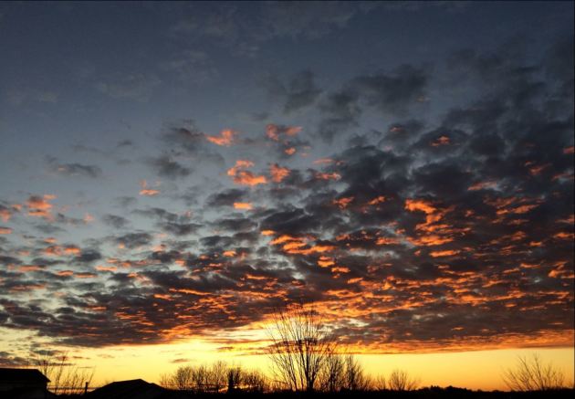

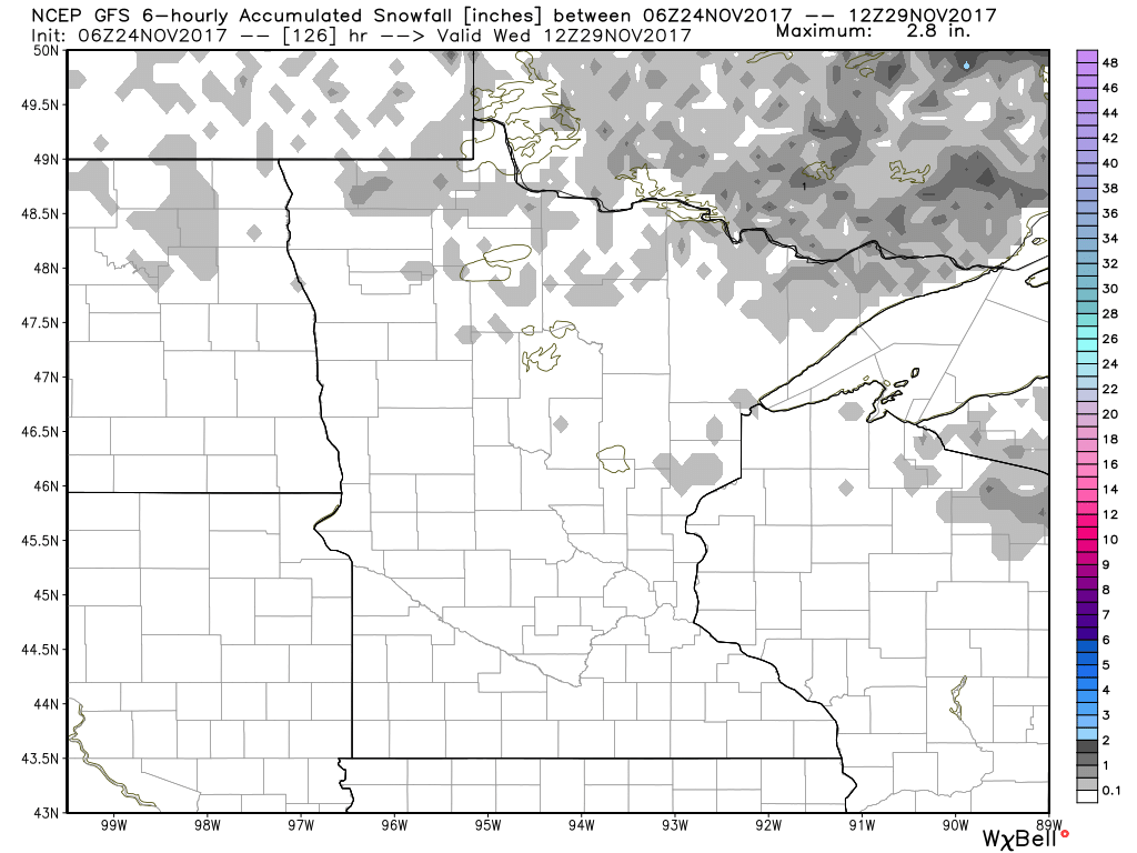
Minimal Snow Chances Ahead
Here’s the snowfall potential through midweek next week, which shows VERY quiet conditions with minimal snow chances over the next 5 days. Snow lovers will have to continue being patient as Old Man Winter takes his sweet time showing up.
 ___________________________________________________________
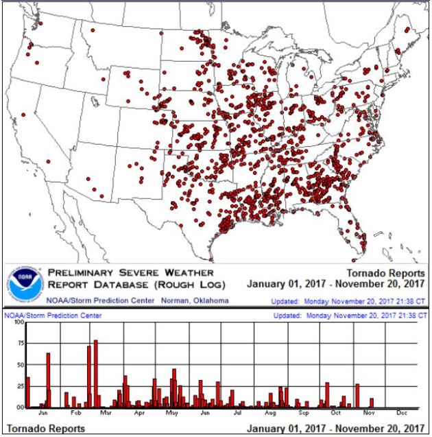
It certainly has been a fairly active first half of 2017 with 1,509 preliminary tornado reports through November 23rd. Note that this is the most tornadoes through that date since 2011, when there were 1,880 reports. The map below shows the distribution of the tornadoes so far this year.
PRELIMINARY 2017 Tornado Count
According to NOAA’s SPC, the PRELIMINARY 2017 tornado count is 1,509 (through November 23rd). Note that is the most active year for tornadoes since 2011, when there were 1,880 tornadoes. Notice that the only other year with more tornadoes than this year was in 2008, which ended with a whopping 2,140 tornadoes nationwide.
.png)
_____________________________________________________________________
National Weather Hazards Ahead…
1.) Heavy snow for parts of the Northern Cascades, coastal range of Northern California, and northern Sierras, Sun, Nov 26.
2.) Heavy snow for parts of the southern Cascades, Bitterroots, and northern Rockies, Sun-Mon, Nov 26-27.
3.) High winds for parts of the western and west-central U.S., Sun-Mon, Nov 26-27.
4.) High winds for southern California, Mon-Tue, Nov 27-28.
5.) Periods of high winds for the Aleutians, extreme southwestern mainland Alaska, and the Alaska peninsula, Sun-Wed, Nov 26-29.
6.) Periods of high significant wave heights for parts of the Aleutians and Alaska peninsula, Sun-Wed, Nov 26-29.
7.) Flooding likely, occurring, or imminent along multiple rives across western and west-central Washington.
Severe drought across parts of the lower and middle Mississippi Valley, Great Plains, Northern Rockies, Arizona, and Hawaii.
.png)
_____________________________________________________________________
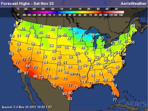
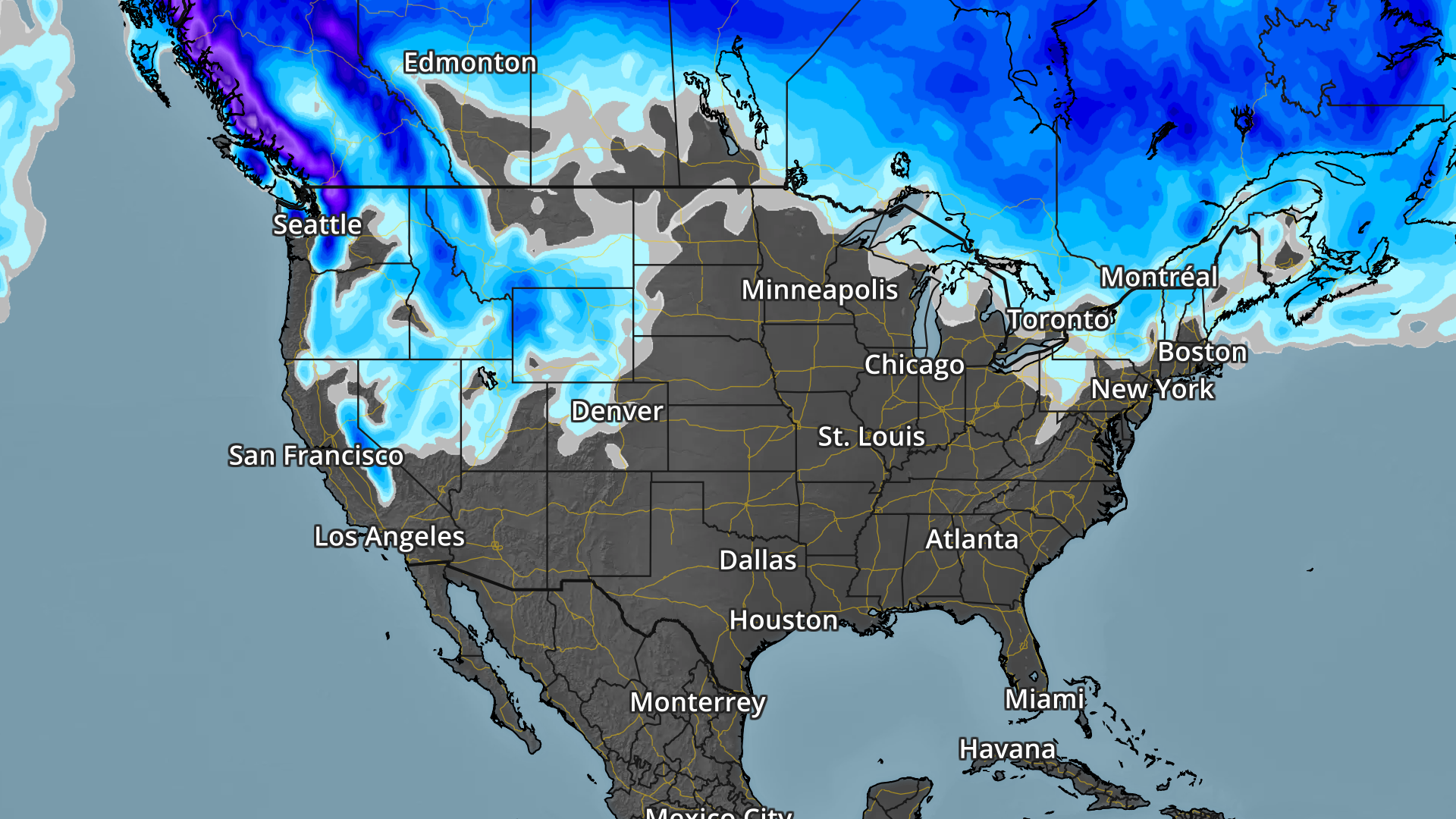
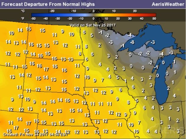
Here’s a look at high temperatures across the nation on Saturday, which suggests that temperatures across much of the nation will still be running above average! Note that areas west of the Mississippi River Valley will be running WELL above average; some locations could be near 20F above average!
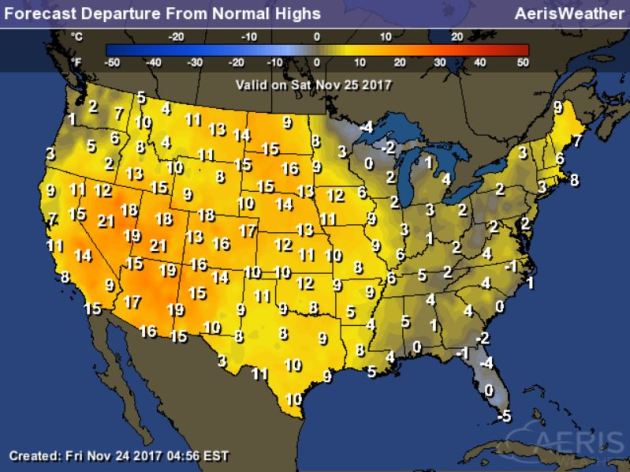
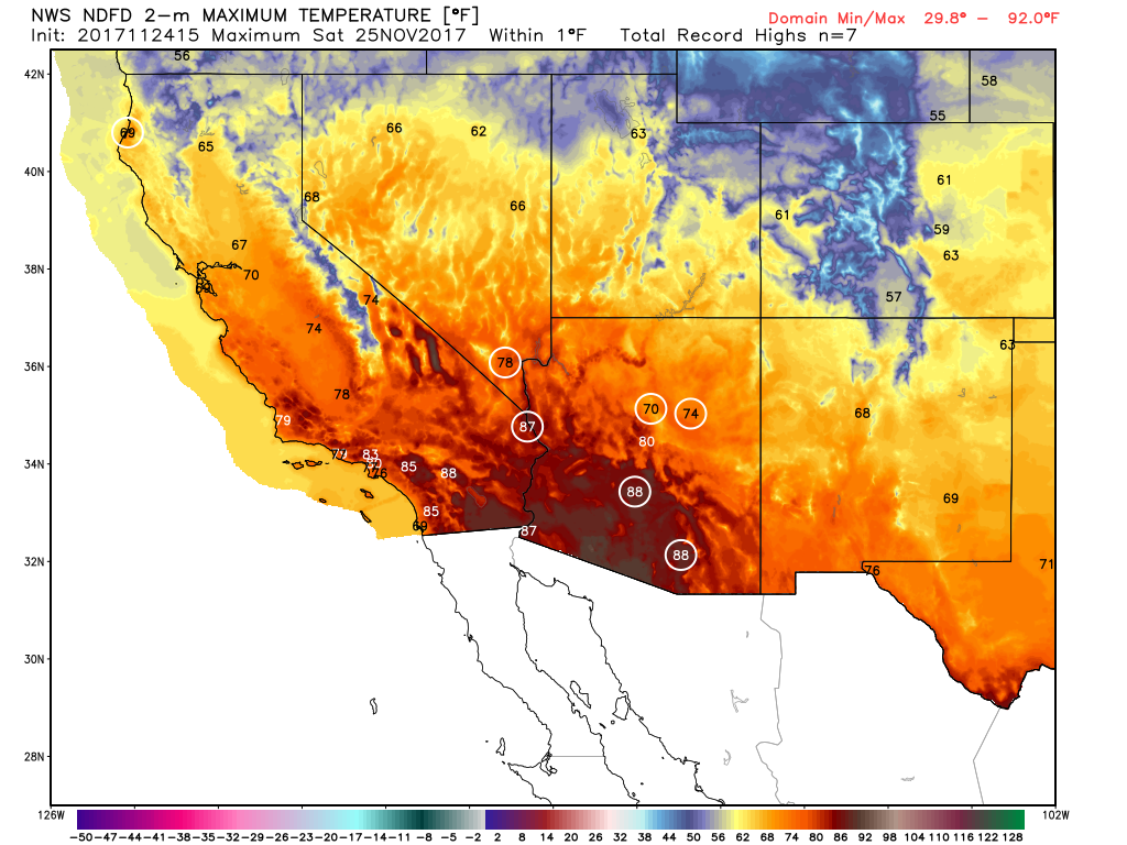
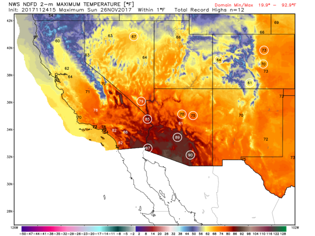
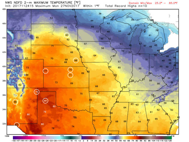
Several record highs were set last week in the Western US, including Los Angeles, CA where they had their hottest Thanksgiving on record as they warmed to 92F! WOW! Here’s a look at the potential record highs that could be set on Saturday, Sunday and Monday.
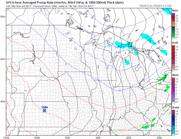
National Weather Outlook
Here’s the weather outlook through Sunday. A quick moving system will roll through the Great lakes and Northeast with light rain/snow chances there. There will be another surge of heavier moisture in the Western US with heavy rain and mountain snow. However, note that much of the nation looks to stay fairly quiet, which is good news for holiday travelers.
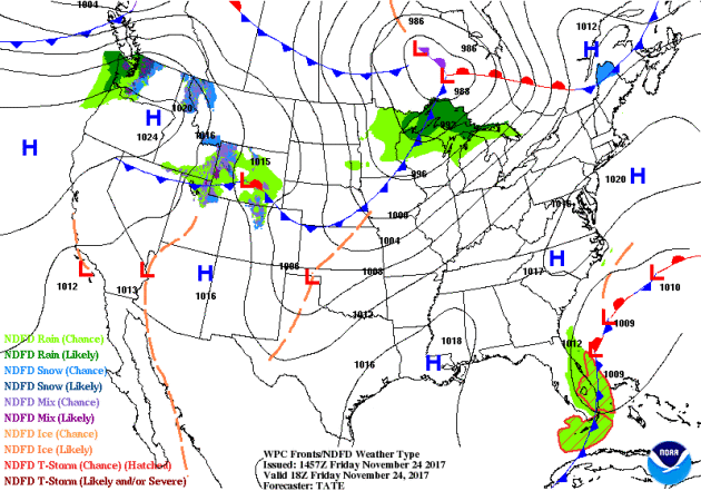
According to NOAA’s WPC, areas of heaviest precipitation will be found across the Western US with double digit liquid tallies possible across the high elevations in the Sierra Nevada Range, Cascades and the Olympic Mountains. There will also be a few areas in the Central & Northern Rockies that see heavy precipitation as well.
.gif)
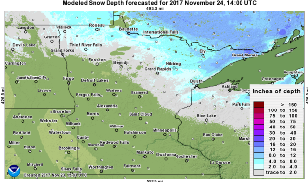
No November Snow – Mild Temps Continue
By Todd Nelson, filling in for Douglas.
I am starting to feel a little cheated. Some people may feel otherwise, but where’s my snow? Sure, I like not having to worry about slipping and sliding on roads around town, but I’d also like to be able to goof around in a snowy landscape with my 2 young boys.
The Twin Cities has had a measly 0.6 inches of snow this month, which is nearly 6 inches below average. Meanwhile, Duluth has had 10.5 inches through the first 24 days of November and 21.6 inches so far this season! Good grief… At this rate, the Twin Cities could tie the 8th least snowy November on record, which was also set in 1913. We’ll see, but I sure don’t see many snow opportunities through the end of the month next Thursday.
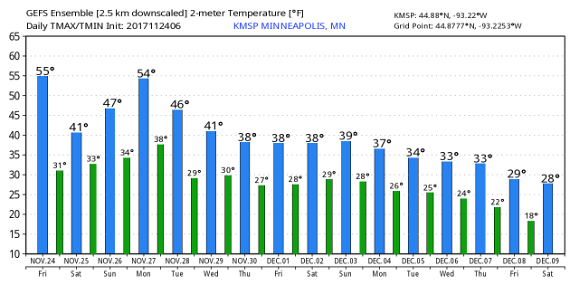
Temperatures will also stay on the mild side as we flirt with the 40s and 50s through early next week. NOAA’s Climate Prediction Center suggests that temps will remain above average as we head through the first 2 weekends in December.
Like I said, I am starting to feel a bit cheated, but Old Man Winter will return at some point!
This Day in Weather History
November 25th
1977: Record lows are set across central Minnesota with lows in the teens below zero. Montevideo had the coldest temperature of 18 degrees below zero along with Long Prairie at 16 degrees below zero.
1820: Ft. Snelling is in the middle of a three-day blizzard that would dump nine inches of snow.
________________________________________________________
Average High/Low for Minneapolis
November 25th
Average High: 36F (Record: 62F set in 1914)
Average Low: 21F (Record: -18F set in 1880)
Record Rainfall: 0.97″ set in 1896
Record Snowfall: 5.3″ set in 1952
_________________________________________________________
Sunrise/Sunset Times for Minneapolis
November 25th
Sunrise: 7:24am
Sunset: 4:36pm
Hours of Daylight: ~9 hours 38 mins
Daylight LOST since yesterday: ~1 minutes and 53 seconds
Daylight LOST since summer solstice (June 20th): 6 hours & 25 minutes
__________________________________________________________
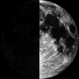
Moon Phase for November 7th at Midnight
0.4 Before First Quarter
_________________________
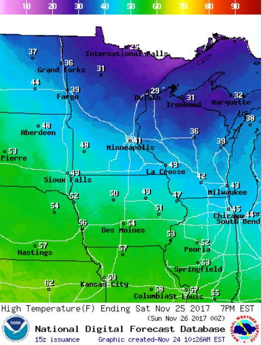
Saturday’s high temps won’t be as warm as what we had Friday, but much of the state will be warmer than average once again. Areas in southwestern MN will be near 10F above average and could warm to near 50F, while areas in northeastern MN will be nearly 5F below average and will only warm into the 20s. However, much of the Midwest will be WELL above average with temps running nearly 10F to 15F above average.
Here’s the temperature outlook through December 9th, which shows very warm temps continuing through the early part of next week where temps will warm in the 40s and 50s. It appears that temps may still be a little warmer than average as we start December, but at least we will be a little closer to average. The extended forecast suggests temperatures dipping into the 20s as we approach the 2nd weekend of December.
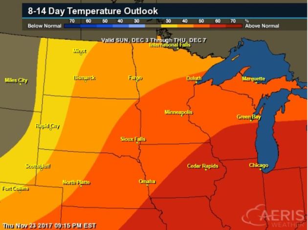
8 to 14 Day Temperature Outlook
Here’s the temperature outlook from into the early part of December, which suggests that temperatures will still be above average for much of the Midwest.
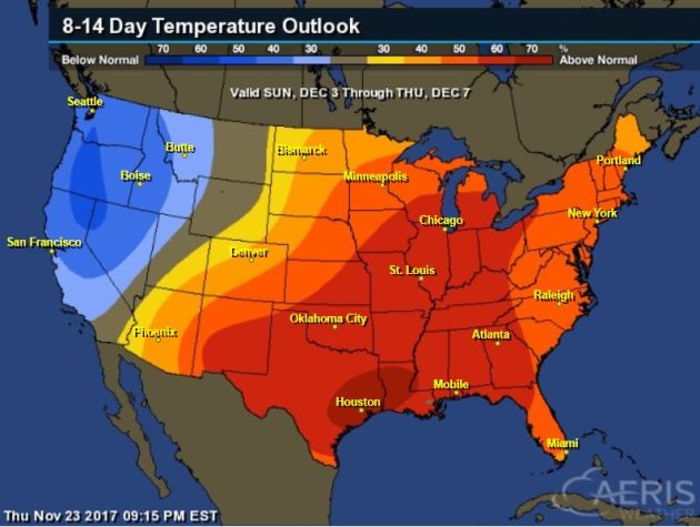
6 to 10 Day Temperature Outlook
According to NOAA’s CPC – much of the nation will remain above average as we head into the early part of December. The only spot that may see below average temps is in the Western US.
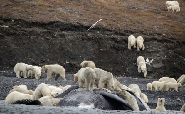
_____________________________________________________________________“Polar bears crowd on Russian island in sign of Arctic change”
“A boatload of tourists in the far eastern Russian Arctic thought they were seeing clumps of ice on the shore, before the jaw-dropping realisation that some 200 polar bears were roaming on the mountain slope. “It was a completely unique situation,” said Alexander Gruzdev, director of the Wrangel Island nature reserve where the encounter in September happened. “We were all gobsmacked, to be honest.” The bears had come to feast on the carcass of a bowhead whale that washed ashore, later resting around the food source. The crowd included many families, including two mothers trailed by a rare four cubs each, Gruzdev told AFP. Climate change means ice, where polar bears are most at home, is melting earlier in the year and so polar bears have to spend longer on land, scientists say.”
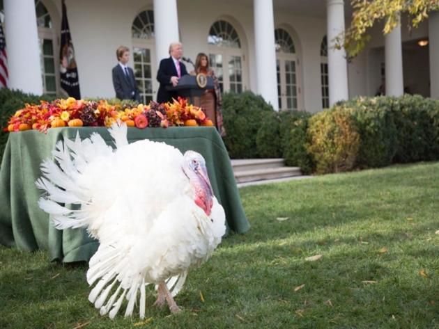
__________________________________________________________________“Six Weather-Climate Related Thanksgiving Facts And Musings”
“Thanksgiving is just around the corner, and it is usually a time for feasts, fun, and family. As I come up for air after binge watching college basketball, I decided to have a little fun with some weather and climate science facts related to Thanksgiving. Here are six facts or musings that crossed my mind. Carbon footprint of your turkey. Many people will eat the traditional thanksgiving turkey. Food and meat production are carbon intensive activities according to the Environmental Working Group report, The Meat Eater’s Guide to Climate Change and Health. The graphic below illustrates that lamb and beef production account for the most significant carbon footprints. The University of Michigan’s Carbon Footprint Factsheet defines carbon footprint as the total greenhouse gas (GHG) emissions caused directly and indirectly by an individual, organization, event or product. It is calculated by summing the emissions resulting from every stage of a product or service’s lifetime (material production, manufacturing, use phase, and end-of-life disposal). Throughout a product’s lifetime, or lifecycle, different greenhouse gases (GHGs) may be emitted, such as methane and nitrous oxide, each with a greater or lesser ability to trap heat in the atmosphere. These differences are accounted for by calculating the global warming potential (GWP) of each gas in units of carbon dioxide equivalents (CO2e), giving carbon footprints a single unit for easy comparison.”
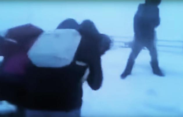
_____________________________________________________________“This Is how Students Get to School in the Russian Arctic”
“The school day in Russia’s northeastern republic of Sakha ended in time for a vicious snowstorm to accompany children during their walk home. A blogger in the region posted a video of their treacherous march on his Twitter feed. Whipped by the freezing winds and snow, the children are seen not so much walking as tumbling over, pulling each other along.”
See more from MoscowTimes HERE:
_______________________________________________________________“The Areas of the U.S. Most Likely to Have a White Christmas This Year”
“We know you’re dreaming of it, but is a white Christmas in the cards for your town? The big day may still be weeks away, but early weather predictions are beginning to give us a glimpse of the holiday in question. While forecasts made this far in advance don’t always pan out, one of the most trusted sources in predicting the year’s weather patterns have put their hat in the ring. The Old Farmer’s Almanac, a resource that’s been used to predict weather patterns, planting charts, and astronomical data since 1792, offers 30 to 60 day long-range weather predictions online, now encompassing the holiday season. Showing “weather trends in temperatures and precipitation,” the predictions are made 18 months in advance, but are said to be “traditionally 80% accurate.”While we can’t guarantee that the Almanac’s forecasts will come to fruition, this first look gives us an idea of what to expect this Christmas. As the holiday fast approaches, keep your eyes on the weather for more up-to-date, specific weather predictions on December 25.”
See more from Travel and Leisure HERE:
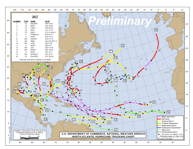
_____________________________________________________________________“2017 hurricane season ends with a number of records”
“Hurricane season officially ends at the end of November, and with nothing currently brewing in the Atlantic, it appears there won’t be another tropical storm or hurricane in what’s been a very active 2017. This year’s hurricane season was the most active since 2012, and it broke and/or tied a number of records. Hurricane after hurricane after hurricane Roughly two weeks after Emily, the beginnings of Hurricane Harvey formed in the middle of the Atlantic, and it would spend the next week churning through the Caribbean and Gulf of Mexico as it got closer to the Texas coast, all while gaining strength. Harvey eventually hit Texas on August 25 as the first Category 4 storm to make a United States landfall since Charley in 2004 and the first major hurricane since Wilma in 2005.”
See more from News 5 Cleveland HERE:
__________________________________________________________________“Thunderstorms create radioactivity, scientists discover”
“Thunder and lightning have sparked awe and fear in humans since time immemorial. In both modern and ancient cultures, these natural phenomena are often thought to be governed by some of the most important and powerful gods – Indra in Hinduism, Zeus in Greek mythology and Thor in Norse mythology. We know that thunderstorms can trigger a number of remarkable effects, most commonly power cuts, hailstorms and pets hiding under beds. But it turns out we still have things to learn about them. A new study, published in Nature, has now shown that thunderstorms can also produce radioactivity by triggering nuclear reactions in the atmosphere. This may sound like the plot of a blockbuster science fiction disaster. But in reality, it’s nothing to worry about. Since the early 20th century, scientists have been aware of ionising radiation – particles and electromagnetic waves that can damage cells – raining down into the Earth’s atmosphere from space. This radiation can react with atoms or molecules, carrying enough energy to liberate electrons from either atoms or molecules. It therefore leaves behind an “ion” with a positive electrical charge.”
See more from The Conversation HERE:
___________________________________________________________

