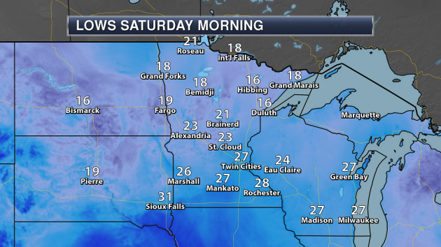
Lows Saturday Morning Across The State
________________________________________________
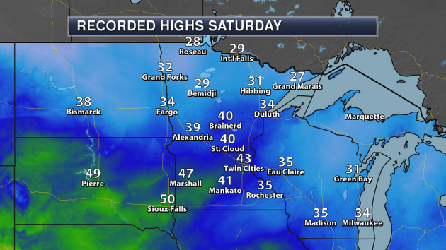
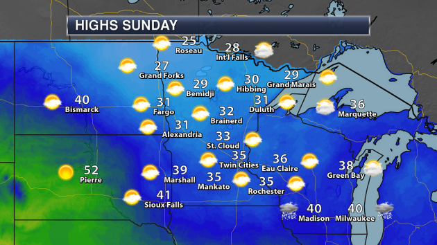
Highs Saturday Across The State (Through 5 PM)
________________________________________________
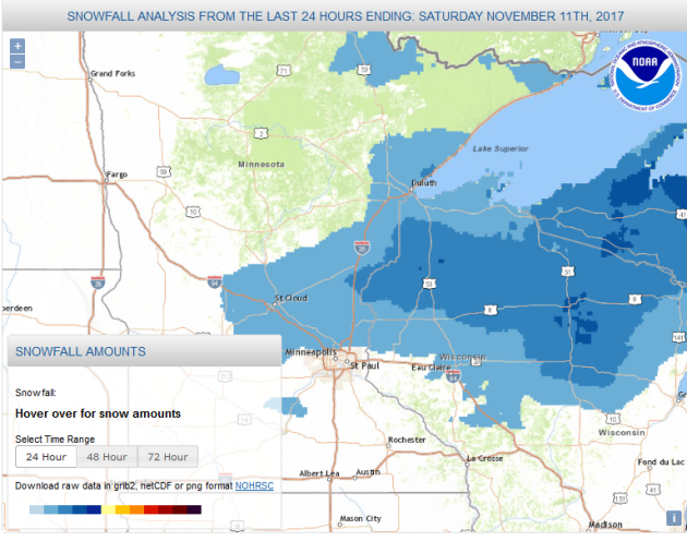
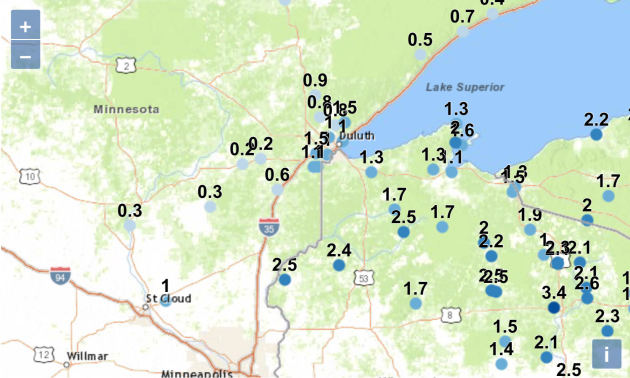
Snowfall Friday Night
While some snow fell across the region Friday Night, the heaviest accumulation was to the north of the Twin Cities – for areas like St. Cloud and Duluth.
Officially, 0.1” of snow fell at the Twin Cities Airport, with 1.1” falling in St. Cloud. Between about a half an inch and a inch and a half fell in the Duluth area, with 1” at the airport.
The Twin Cities airport is the only NWS climate location in the state that has received below average snowfall so far this season. Duluth is “winning” the snow race, thanks to the late October storm that brought the airport 10.6” on the 27th.
________________________________________________
Drier, Milder Weather Bias Into Thanksgiving
By Paul Douglas
On this date in 1940 the Armistice Day Blizzard was winding down, after dumping over 16 inches of snow on the Twin Cities and 27 inches at Collegeville. High winds carved out massive drifts. Trains got stuck, people slept in their offices. Hunters were stranded – food was dropped from airplanes. Some roads were shut down for nearly 2 weeks. 49 Minnesotans lost their lives.
Back then forecasts originated from the Weather Bureau office in Chicago, but this storm resulted in the creation of a local office.
I want to believe that new technology, better weather models and streamlined warnings mean we couldn’t get caught with our Dopplers down again. But history has a way of repeating itself. The Halloween Storm of 1991 comes to mind.
No drama here anytime soon, just a welcome warming trend. Highs poke into the 40s much of this week and long-range models suggest a mainly dry Thanksgiving week close to home, with more 40s – even a shot at a few 50s.
Unusually cold spells are often followed by mild blips. Winter loses much of its sting the next 2 weeks. Yes, “average” sounds good.
________________________________________________
Extended Twin Cities Forecast
SUNDAY: Cool sunshine. High 38. Low 26. Chance of precipitation 10%. Wind NW 7-12 mph.
MONDAY: Intervals of sun, trending milder. High 44. Low 36. Chance of precipitation 10%. Wind S 7-12 mph.
TUESDAY: Milder with a chance of drizzle. High 51. Low 34. Chance of precipitation 40%. Wind S 8-13 mph.
WEDNESDAY: Some sun with a cooler breeze. High 41. Low 28. Chance of precipitation 20%. Wind NW 10-20 mph.
THURSDAY: Patchy clouds, temps. close to average. High 42. Low 37. Chance of precipitation 20%. Wind SE 10-15 mph.
FRIDAY: Cold rain may end as few snowflakes. High 43. Low 28. Chance of precipitation 60%. Wind SW 8-13 mph
SATURDAY: Intervals of sun, turning chillier. High 36. Low 21. Chance of precipitation 20%. Wind NW 10-20 mph.
________________________________________________
This Day in Weather History
November 12th
2000: A winter storm system produces a narrow band of heavy snow across extreme western Minnesota. Winds toward the end of the event were clocked between 15 and 25 mph, resulting in blowing snow leading to visibilities of 1 to 1.5 miles. Some snow totals included: Canby (Yellow Medicine County) with 6.5 inches, Madison (Lac Qui Parle County) with 6.0 inches.
1940: Record low highs are set in west central Minnesota. Alexandria records a high of 8 degrees Fahrenheit, Springfield and Willmar have highs of 10 degrees, and St. Cloud and Minneapolis have highs of 11 degrees.
1933: A dust storm hits southwest Minnesota, while a blizzard rages in the northwest part of the state.
________________________________________________
Average Temperatures & Precipitation for Minneapolis
November 12th
Average High: 43F (Record: 65F set in 2001)
Average Low: 28F (Record: -4F set in 1966)
Average Precipitation: 0.06″ (Record: 0.90″ set in 1965)
Average Snow: 0.2″ (Record: 8.5″ set in 1940)
________________________________________________
Sunrise/Sunset Times for Minneapolis
November 12th
Sunrise: 7:07 AM
Sunset: 4:47 PM
*Length Of Day: 9 hours, 40 minutes and 1 second
*Daylight Lost Since Yesterday: ~2 minute and 28 seconds
*Latest Sunrise At/After 7:30 AM: November 30th (7:30 AM)
*Earliest Sunset: December 5th-13th (4:31 PM)
________________________________________________
Minnesota Weather Outlook
Temperatures will be cooler Sunday vs. Saturday across southern Minnesota, with highs only in the mid 30s. Temperatures will be in the mid 20s to low 30s across northern Minnesota. A mix of clouds and sun can be expected across the state.
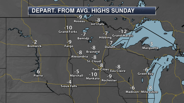
Highs across the state Sunday will be 5-10 degrees below average for this time of year.
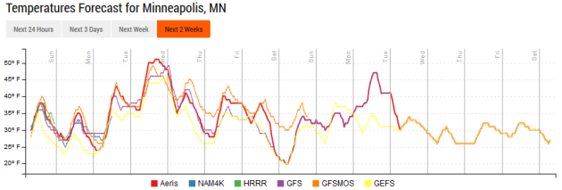
We will stay cool Sunday, but then warm into the 40s Monday and the 50s Tuesday. Unfortunately, those 50s won’t last, as another shot of cooler air will move in behind the rain expected late Tuesday. However, temperatures are expected to stay in the 40s for most of the work week, eventually cooling into the 30s for next weekend.
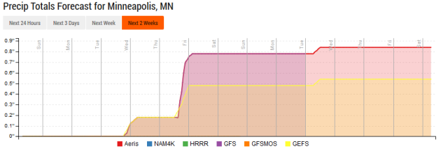
While we are expecting mainly dry weather Sunday and Monday, a system will bring in a chance of rain to the upper Midwest Tuesday and Tuesday Night. Rain totals will likely be less than an quarter inch. Another system brings the chance of rain and snow to the region late Thursday into Friday.
________________________________________________
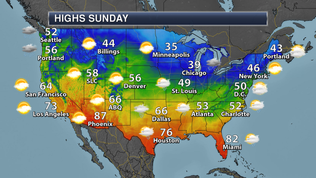
National Weather Forecast
Some rain and snow is likely across the Great Lakes on Sunday as a low pressure center passes through the region, with some showers extending to the Mid-Atlantic. A few showers are possible from southern Texas to the Southeast due to Gulf of Mexico/Atlantic moisture streaming into the respective regions. Rain and heavy mountain snow is likely across the Pacific Northwest as low pressure slowly moves toward the coast.
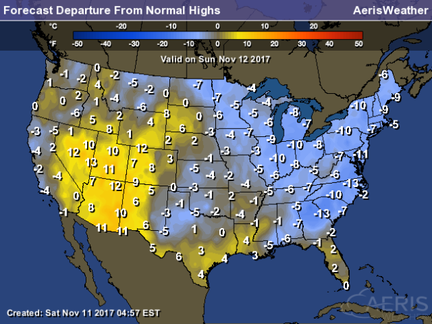
Cool weather will continue across most of the central and eastern United States, with highs that are 5-15 degrees below average. Places that will see highs above average including the Great Basin and along the western Gulf Coast. In parts of the Four Concerns, highs will be up to 15 degrees above average.
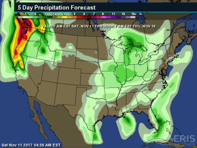
The heaviest precipitation through the middle of the week is expected in the Northwest. Some areas (at mainly higher elevations) could receive over a foot of melted precipitation. Elsewhere, an inch of rain is possible along the southeast Florida coast.
________________________________________________
iPhone X Has Issues In Cold Weather
So you just bought a $1,000 phone – and it turns out it doesn’t work properly in the cold. That’s what some iPhone X owners are finding out. More from Gizmodo: “Just in time for winter, some users discovered a software bug causing the iPhone X to freeze up in cold weather. Disappointing, but what do you expect from a phone that only costs as much as a few cups of coffee? “It literally takes 2 seconds from going inside to the cold outdoors and my screen stops being very responsive,” Reddit user darus214 wrote. “I try swiping on websites and it doesn’t register my finger.”” (Photo: Gizmodo/Alex Cranz)
Al Gore Wants Help From The Tech World
The former vice president wants the tech world to help combat climate change.
More from CNET: “
Tech is already making the world a better place. It is helping refugees integrate into society, it is empowering people with disabilities, and connecting communities. Al Gore believes it can been instrumental in reversing climate change. “My purpose here is to recruit you to be part of the solution to the climate crisis,” he told the audience at Web Summit — Europe’s biggest tech conference — in Lisbon on Thursday. “You can have a bigger impact than practically any other group in the entire world.”“
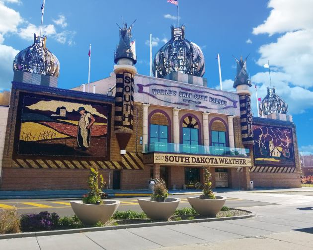
Corn Palace Redecorated Despite Drought
While the drought delayed murals being completed for the 2017-2018 Corn Palace theme (South Dakota Weather), they are now nearly completed.
More from KSFY-TV: “
The lead decorator for the murals, Dan McCloud, said the decorators are about a week behind schedule because of the drought. He was worried he wouldn’t even get any corn. Then, the rain came but some of the colors on the corn still didn’t turn out as he wanted. Waiting this late in the year also makes it harder to decorate.” (Image:
Corn Palace on Facebook)
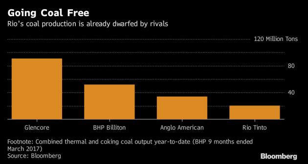
A Coal-Free Miner
The second largest miner in the world – Rio Tinto Group – is selling off its last coal mines.
More from Bloomberg: “
Just five years ago it would have been almost unthinkable that one of the world’s biggest mining companies would not dig any coal. It’s now likely to become a reality. Rio Tinto Group, the world’s second-largest miner, has been steadily backtracking from coal to focus on better assets. It’s now looking for buyers for its remaining coal mines in Australia, and a sale will mark a complete exit from the fuel.” (Image: Bloomberg)
______________________________________________