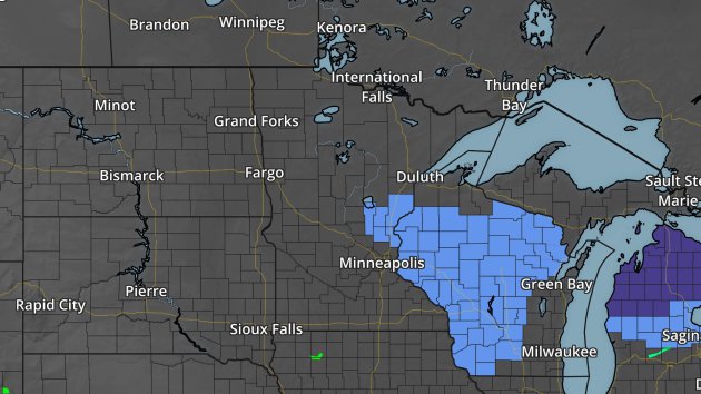
Frost Advisory Tuesday Night

The National Weather Service has issued a Frost Advisory (lighter blue) for parts of east central Minnesota into western Wisconsin Tuesday Night. Temperatures are expected to get down into the low and mid 30s for lows by daybreak Wednesday.
Meteor In The Northeast

Credit: Burlington Airport
Those who were up late enough Monday Night (around 12:50 AM ET) in parts of the Northeast were lucky enough to catch a spectacular meteor streak across the sky! Three different security cameras at the Burlington, VT airport caught the fireball as it flew through the night sky. It was a very photogenic meteor, as dashboard cams from the Portland, ME and Plattsburgh, NY Police Department also caught the very bright meteor on camera.
Read more about the Monday Night meteor event in the Northeast from the American Meteor Society.
Wet Spring So Far… For Some
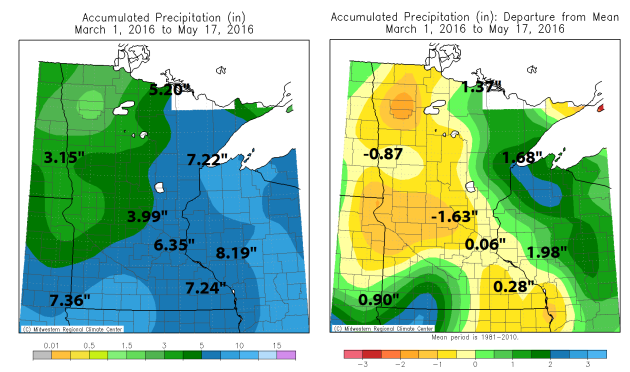
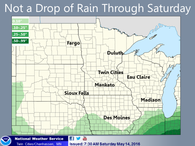
After a wet week last week, with four out of the five weekdays recording rainfall in the Twin Cities, I figured it was time to pull out the precipitation map for spring (since March 1st) so far. There have been a couple clear areas of wet weather this spring where precipitation is above average – one in southwest Minnesota (where some areas are a good 1-3″ above average according to the Midwest Regional Climate Center) and another across much of northeast Minnesota. In fact, the 5.20″ of rain in International Falls makes it the 13th wettest first 77 days of spring in history. Meanwhile, if you head out to northwest and west central Minnesota that’s where you find the driest weather over the past two and a half months. St. Cloud is 1.63″ below average for this time of spring.
_______________________________________________
Minnesota Crop Update
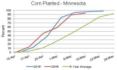
The USDA and the Minnesota Department of Agriculture issued its weekly crop update Monday for the state of Minnesota. While most crops are ahead of schedule (versus the five year average) when it comes to planting, including corn, last week only provided an average of 2.3 days suitable for work in the fields. That was even less in southern Minnesota due to continued precipitation. There is also concern about how the frost/freeze last weekend may have affected development – potentially even causing damage. Read more from the USDA here.
The good news, according to University of Minnesota Extension corn specialist Jeff Coulter, is that while there may be injury to the corn from the frost, it shouldn’t have killed the corn: “The growing point on corn seedlings is currently about 0.75 inches below the soil surface and remains below the soil until the five to six leaf-collar stage. Therefore, frost prior to the five to six leaf-collar stage typically does not kill corn unless prolonged cold temperatures freeze the upper part of the soil where the growing point is located.“
Meanwhile, the grape crop at the Wollersheim Winery in Wisconsin took the worse hit they’ve had in about three decades. More from KARE-11: “Head winemaker Philippe Coquard says the temperature dropped to 27 degrees early Sunday and despite the heating equipment used to save the grape crop, the entire 32-acre vineyard at Prairie du Sac was damaged. Coquard says 75 percent of the red grapes have been lost and 25 percent of the white grapes.”
By: Paul Douglas
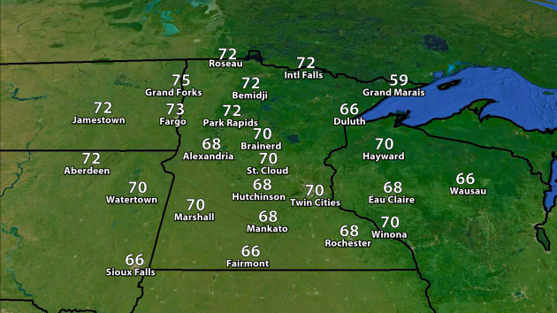
WEDNESDAY: Sunny. Wow! High 70. Low 48. Chance of precipitation: 0%. Wind: S 3-8 mph.
THURSDAY: Sunny, breezy and milder. High: 72. Low: 50. Chance of precipitation: 0%. Wind: S 8-13 mph.
FRIDAY: Feels like a comp day to me. Sunny. High: 73. Low: 55. Chance of precipitation: 0%. Wind: SE 8-13 mph.
SATURDAY: Warm sun. Go jump in a lake. High: 75. Low: 58. Chance of precipitation: 0%. Wind: S 8-13 mph.
SUNDAY: Sunny, feels like mid-June. High: 81. Low: 61. Chance of precipitation: 0%. Wind: S 10-20 mph.
MONDAY: Sticky sun, thunder late. High: 82. Low: 62. Chance of precipitation: 40%. Wind: S 10-20 mph.
TUESDAY: Better chance of T-storms. High: 80. Low: 60. Chance of precipitation: 70%. Wind S 10-15 mph.
_______________________________________________
This Day in Weather History
May 18th
1980: Mt. St. Helens erupts. The smoke plume eventually rises to 80,000 feet, circling the earth in 19 days. Brilliant sunsets due to the smoke are seen over Minnesota for days afterward.
1933: Tornadoes hit McLeod and Mower counties.
_______________________________________________
Average Temperatures & Precipitation for Minneapolis
May 18th
Average High: 70F (Record: 93F set in 2012)
Average Low: 50F (Record: 27F set in 1915)
Average Precipitation: 0.10″ (Record: 1.57″ set in 1892)
Average Snowfall: 0.0″ (Record: 2.0″ in 1915)
________________________________________________
Sunrise/Sunset Times for Minneapolis
May 18thSunrise: 5:40 AM
Sunset: 8:39 PM
*Length Of Day: 14 hours, 59 minutes and 2 seconds
*Daylight Gained Since Yesterday: ~2 mins & 8 secs
*Next Sunrise That Is Before 5:30 AM: June 1st (5:29 AM)
*Next Sunset That Is After 9 PM: June 13th (9:01 pm)
Wednesday Minnesota Weather Outlook
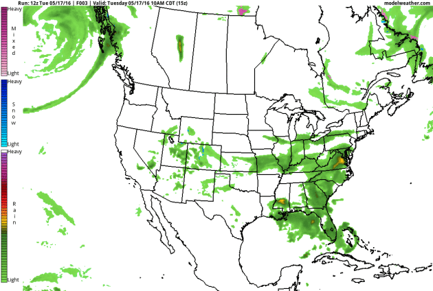
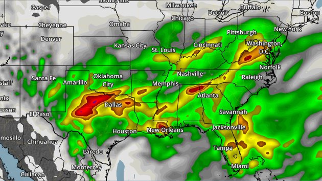
The storm track will remain south of Minnesota as we work through the rest of the week. A frontal system sagging southward will be a focus for the potential of heavy rain across portions of the southern and eastern U.S. over the next few days. Also, as we head into Thursday and the end of the week, we’ll watch a cut off low move south over the northwest U.S. that will bring them an extended period of showers and storms.
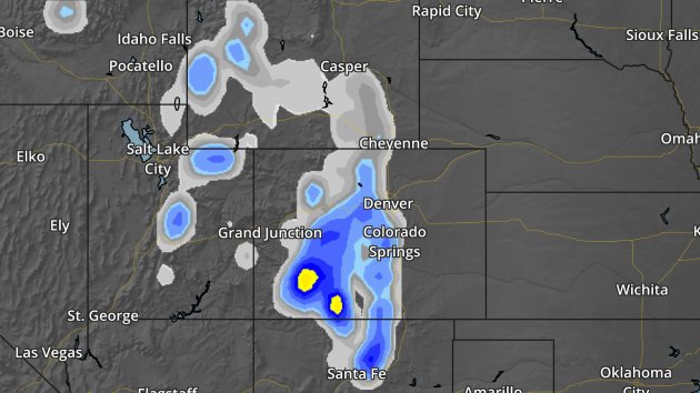
Snowfall potential through Thursday. Blues indicated totals between 1-6″, yellow 6″+.
Thanks for checking in and have a great Wednesday! Don’t forget you can follow me on Twitter (@dkayserwx) or on Facebook (Meteorologist D.J. Kayser)!
– D.J. Kayser

