
.png)
.gif)
____________________________________________________________________
____________________________________________________________________________
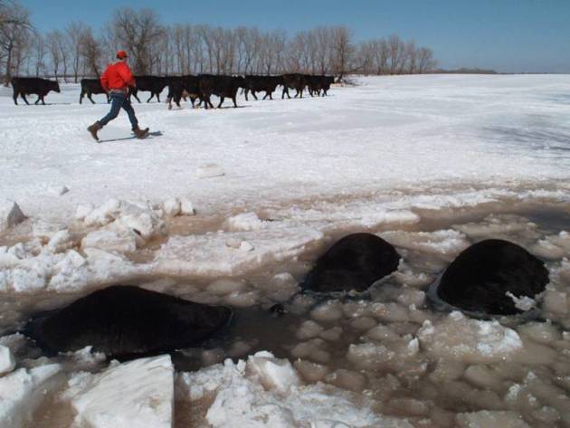
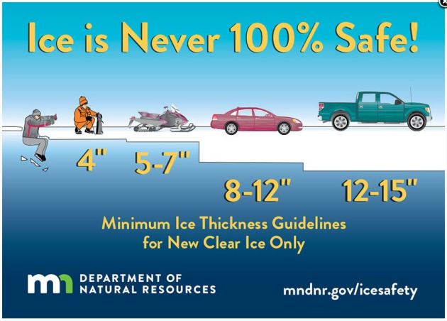
Under 4″ – STAY OFF
4″ – Ice fishing or other activities on foot
5″ – 7″ – Snowmobile or ATV
8″ – 12″ – Car or small pickup
12″ – 15″ – Medium truck
Many factors other than thickness can cause ice to be unsafe.
White ice or “snow ice” is only about half as strong as new clear ice. Double the above thickness guidelines when traveling on white ice.
___________________________________________________________________
.png)
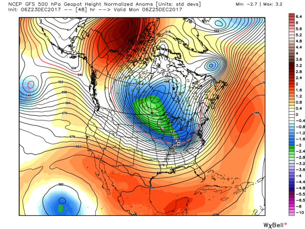
Arctic Air MassArrives
High Temps Sunday
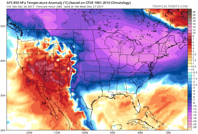
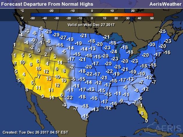
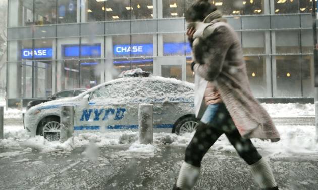
High temperatures on Wednesday will still be VERY chilly across much of the country with temperatures running nearly 10F to 20F+ below average. Meanwhile, warmer than average temperatures will continue in the southwestern part of the country and also in southern Florida.
.gif)
According to NOAA’s WPC, the 5 day precipitation outlook suggests areas of heavier precipitation continuing across the Northwestern part of the country through AM Sunday. Some of the higher elevations there could see several inches of liquid accumulation, which could lead to feet of snow! There may also be areas of heavier rain near the Lower Mississippi Valley.
.gif)
.png) __________________________________________________________________________
__________________________________________________________________________
 ___________________________________________________________________________
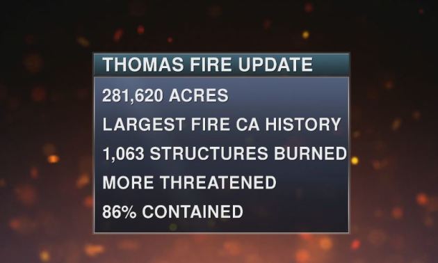
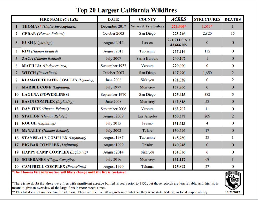
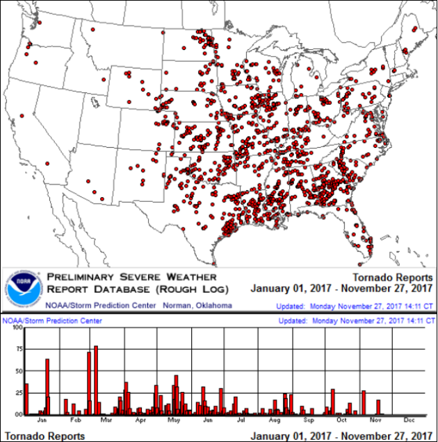
It certainly has been a fairly active first half of 2017 with 1,522 preliminary tornado reports through December 25th. Note that this is the most tornadoes through that date since 2011, when there were 1,897 reports. The map below shows the distribution of the tornadoes so far this year.
PRELIMINARY 2017 Tornado Count
According to NOAA’s SPC, the PRELIMINARY 2017 tornado count is 1,522 (through December 25th). Note that is the most active year for tornadoes since 2011, when there were 1,897 tornadoes. Notice that the only other year with more tornadoes than this year was in 2008, which ended with a whopping 2,140 tornadoes nationwide.
.png)
_____________________________________________________________________
National Weather Hazards Ahead…
1.) Heavy precipitation across portions of the Pacific Northwest, Thu-Fri, Dec 28-Dec 29.
Heavy snow across portions of the Pacific Northwest, the Northern Rockies, and the Northern Great Basin, 2.) Thu-Fri, Dec 28-Dec 29.
3.) Heavy snow across portions of Maine, Sat, Dec 30.
4.) High winds across portions of the Mid-Atlantic and the Northeast, Sat-Sun, Dec 30-Dec 31.
5.) Much below normal temperatures from the Great Lakes to the Mid-Atlantic and Northeast, Thu, Dec 28.
6.) Much below normal temperatures across portions of the Northern and Central Plains, and the Northern Rockies, Thu-Fri, Dec 28-Dec 29.
7.) Much below normal temperatures from the Northern and Central Rockies to the Southern Plains, Lower Mississippi Valley and eastward to the Mid-Atlantic and Northeast, Sat-Mon, Dec 30-Jan 1.
8.) Heavy precipitation across portions of mainland Alaska, Sun-Mon, Dec 31-Jan 1.
9.) Slight risk of much below normal temperatures from the eastern Rockies to the East Coast, Tue-Fri, Jan 2-Jan 5.
10.) Moderate risk of much below normal temperatures for portions of the Great Plains, the Mississippi Valley, the Tennessee Valley, the Ohio Valley, the Central and Southern Appalachians, the Great Lakes, the Northeast, the Mid-Atlantic, and the Southeast,Tue-Thu, Jan 2-Jan 4.
11.) High risk of much below normal temperatures for portions of the Lower and Middle Mississippi Valleys, the Tennessee Valley, the Ohio Valley, the Great Lakes, the Southern and Central Appalachians, the Northeast, the Mid-Atlantic, and the Southeast, Tue-Wed, Jan 2-Jan 3.
12.) Severe Drought across the Central Plains, the Lower Mississippi Valley, the Central Great Basin, the Northern Plains, Hawaii, the Northern Rockies, the Middle Mississippi Valley, the Southern Plains, and the Southwest.
.png)
_____________________________________________________________________
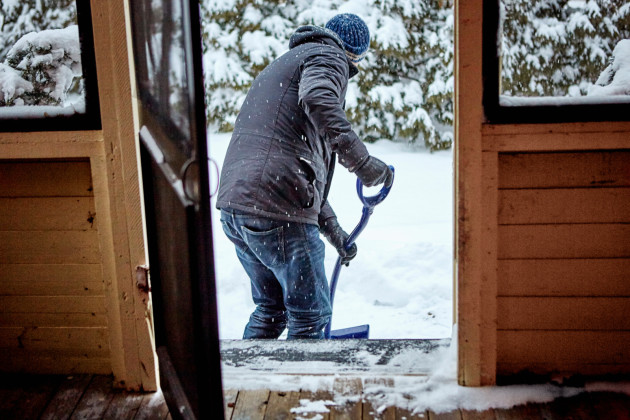
Enough Snow to Plow and Shovel on Thursday?
By Paul Douglas
Even though the least daylight came on December 21, the Winter Solstice, our temperatures don’t usually bottom out until the third week of January. This “seasonal lag” is the result of snow and ice expanding over North America, coupled with long nights. A rising sun angle doesn’t begin to counteract those factors until late January, when average temperatures start to rise.
Which brings up a delicate question I float every winter: can you feel colder than numb? Mail carriers and ice fishermen swear you can tell the difference between -5 and -20F. Not sure. Maybe a colder air temperature gets you to numb faster?
Our biggest snows often come after an arctic invasion, with a deep layer of frigid air overhead. Models consistently print out a few inches of snow Thursday, and it may even be a plowable snow event. Imagine that.<p>A reinforcing shot of invigorating Yukon air may keep the mercury below zero New Year’s weekend, but 20s may return late next week, even 30F 2 weeks out.
Yes, we live in the Super Bowl of Weather but odds are it won’t be quite this NANOOK on February 4.
________________________________________________________________________
Extended Forecast
WEDNESDAY: Fading sun. Chilly. Winds: SW 3-8. Wake-up: -11. Feels Like: -20. High: 4.
WEDNESDAY NIGHT: Snow, mainly after midnight. Low: 0. Feels Like: -11.
THURSDAY: Snow accumulations 1″ to 3″. Slow commutes. Winds: S 7-12.. High: 13.
FRIDAY: Turning colder. Coating of flurries. Winds: NW 10-15. Wake-up: -2. High: 5.
SATURDAY: Brittle sunshine, feels like -20F. Winds: NW 8-13. Wake-up: -12. High: -3.
SUNDAY: Early flurries. Still bitter. Winds: 5-10. Wake-up: -13. High: 0.
MONDAY: Cold start. At least the sun is out. Winds: NW 3-8. Wake-up: -15. High: 2
TUESDAY: Partly sunny. Still fairly numb. Winds: SE 3-8. Wake-up: -12. High: 6.
_______________________________________________________
This Day in Weather History
December 27th
1982: A snowstorm starts across the state, and ultimately dumps 16 inches in the Twin Cities by the time it ends on the 28th.
_______________________________________________________
Average High/Low for Minneapolis
December 27th
Average High: 24F (Record: 46F set in 1959)
Average Low: 9F (Record: -24F set in 1886)
Record Rainfall: 0.70″ set in 1959
Record Snowfall: 6.0″ set in 1979
_________________________________________________________
Sunrise/Sunset Times for Minneapolis
December 27th
Sunrise: 7:50am
Sunset: 4:38pm
Hours of Daylight: ~8 hours 48 mins
Daylight GAINED since yesterday: ~27 seconds
Daylight GAINED since winter solstice (December 21st): 2 minute
__________________________________________________________
Moon Phase for December 27th at Midnight
1.9 Since First Quarter Moon
_________________________
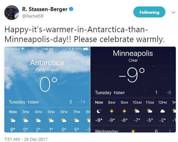
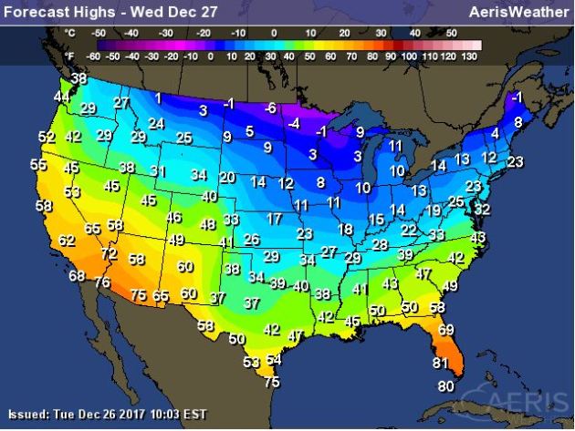
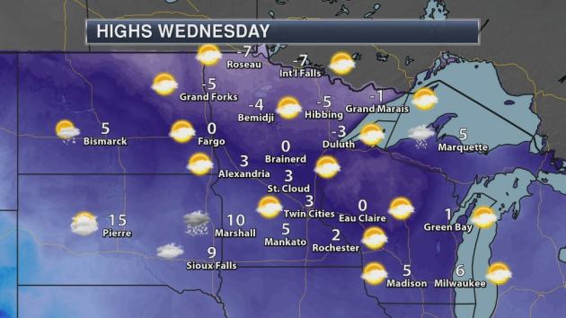
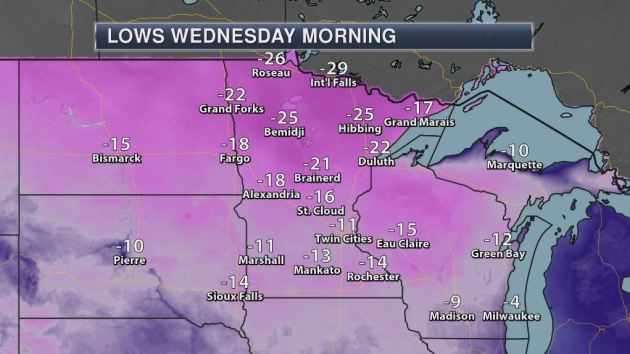
High temps on Wednesday will be VERY cold across much of the region with readings still nearly -15F to -25F below average! Some locations across the far northern reaches of Minnesota will still not make it above 0F for daytime highs.
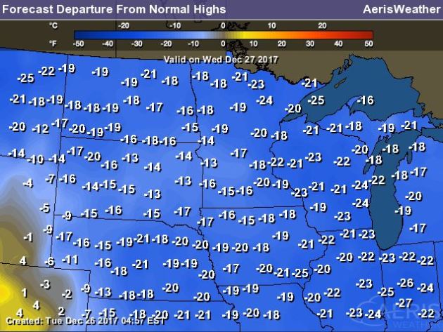
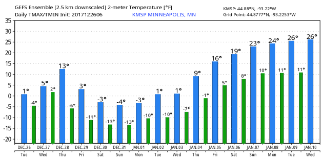
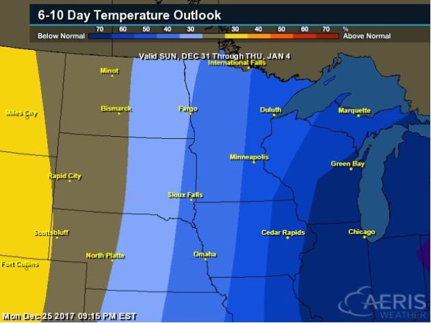
Here’s the temperature outlook through the 1st week of January, which suggests MUCH colder than average temperatures sticking around much of the Midwest and Great Lakes through the time period. With winter officially here, it looks like winter-like temps will be present.
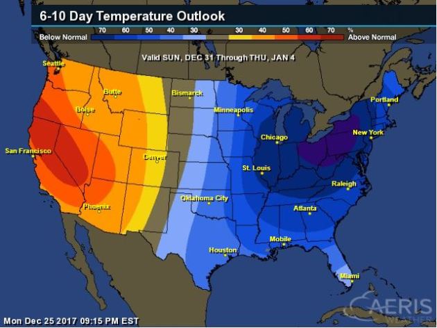
8 to 14 Day Temperature Outlook
Here’s the extended temperature outlook as we head through the 1st week of January. Note that colder than average temperatures look to stick around through much of the eastern two-thirds of the nation, while warmer than average weather will be found in the Western US.
____________________________________________________________________________
____________________________________________________________________________
____________________________________________________________________________
_____________________________________________________________________________
Thanks for checking in and don’t forget to follow me on Twitter @TNelsonWX