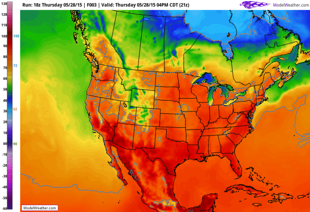
84 F. high temperature at KMSP Thursday afternoon.
73 F. average high on May 28.
81 F. high on May 28, 2014.
May 28, 1965: Late season snow falls across all of Minnesota with Duluth and Caribou reporting an inch.

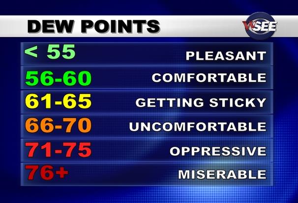
Merits of Dew Point
“It’s not the heat it’s the humidity.” Chances are you’ve heard that before, and it’s true. When there’s considerable water in the air your body’s natural cooling system (evaporating sweat off your skin) doesn’t work nearly as efficiently, making it easier to overheat.
Relative humidity is just that, relative to the temperature. A humidity of 90 percent on a day when it’s 60F is tolerable. But a relative humidity of 45 percent on a 95 degree day is hideous; like living in a close-in suburb of Hades.
Dew point is a much better indicator, an absolute value, one number that instantly sums up how it really feels outside. Anything above 60 is sticky, 70 feels tropical, 80 is dangerous. In the 7-Day, where appropriate, I’ll be mentioning dew point (DP) to try and set sweaty expectations.
Showers and a few heavier T-storms blossom today with some half-inch-plus rainfall amounts. Have a Plan B, especially evening hours. Cool, dry Canadian exhaust treats us to a fresh blue-sky weekend.
Dew points drop from 60F to 40F, meaning half as much water in the air.
A sticky warm front surges north next week; more 80s with a dew point that will make you want to quickly change the subject.
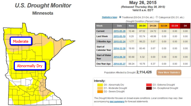
Minnesota’s Drought is Fading Fast. The same shift in the pattern bringing historic rains to Texas and Oklahoma is also fueling more heavy rain for Minnesota, and the drought that kicked off spring in the Upper Midwest is fizzling faster than you can say “weather whiplash”. In one week moderate drought went from affecting nearly half of Minnesota to 24% of the state. Parts of central and far southern Minnesota are now drought-free. At the rate we’re going much of the state may be in good shape with soil moisture and lake/river levels within another 2-3 weeks. The latest U.S. Drought Monitor for Minnesota is here.
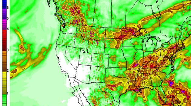
7-Day Rainfall Forecast. NOAA’s GFS model is predicting some 2-4″ rainfall amounts from the eastern Dakotas into the Red River Valley and Minnesota Arrowhead over the next week, some of that coming Friday, another shot of moisture next week. Texas will see more heavy rains over the next 3-4 days, while bone-dry conditions persist over California.
Short-Term Cooling Trend. GFS guidance shows cooler, drier air surging south of the border, resulting in free A/C from the Upper Midwest into the Great Lakes and eventually New England. Any respite from the humidity and T-storms will be brief as another warm front pushes north next week. Guidance: NOAA, animation: AerisWeather.
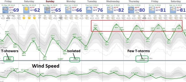
A Very Comfortable Weekend. Highs hold in the upper 50s to low 60s Saturday under blue sky; Sunday will be a few degrees milder but clouds will increase with the best chance of a PM shower west of MSP. We warm up next week; another streak of 80s with a few heavy T-storms Thursday. Source: Weatherspark.
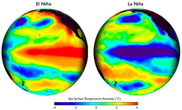
Hopes Rise For a Strong El Nino To Ease California Drought. The same warm phase of the Pacific that’s spiking rainfall amounts for Texas and Oklahoma may bring more much-needed rain to California later this year; here’s an excerpt of a story at The Los Angeles Times: “…El Niños have been responsible for two of California’s wettest and most destructive rainy seasons: the winters of 1982-83 and 1997-98. Now, experts say, a potentially powerful El Niño this winter could be the beginning of the end of the drought. This month’s weather suggests how El Niño’s building strength is already affecting the United States. It’s giving weather scientists reason to be cautiously optimistic that it has the stamina to see it through California’s rainy season, which typically begins in October and ends in April...” (File image above).

The Science Behind an Indian Heat Wave. Here’s a snippet of an interesting explainer from Indian Real Time at The Wall Street Journal: “…The severe heat wave gripping parts of India started gathering force when cyclonic patterns of clouds and winds over the Bay of Bengal drifted away, bringing an abrupt end to pre-monsoon showers. Although high temperatures are commonplace during the summer season in India between April and June, sporadic rains–often the result of cyclonic, or low-pressure, systems–provide temporary relief. But the heat-beating clouds over the Bay of Bengal recently drifted northwest leaving behind an Indian heat wave…”
Photo credit above: “An Indian commuter uses the train’s hose pipe to cool down on May 24, 2015 at the railway station in Allahabad, India. Most of northern India has been reeling under a heat wave with temperatures soaring to over 46 degree Celsius.” (Prabhat Kumar Verma/Zuma Press/TNS).
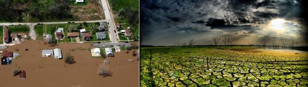
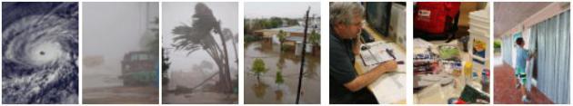
Texas Was In A Horrible Drought Last Year. Now It’s Flooded. What Gives? Houston saw 1 inch of rain in 5 minutes? Meteorologist Eric Holthaus puts things into perspective at Slate; here’s an excerpt: “…A steadily escalating whipsaw between drought and flood is one of the most confident predictions of an atmosphere with enhanced evaporation rates—meaning, global warming. Since 1958, there’s been a 16 percent increase in the amount of rain falling in the heaviest rainstorms on the Plains, even as long-term projections point toward an increased risk of megadrought. Both of these can happen at the same time...”
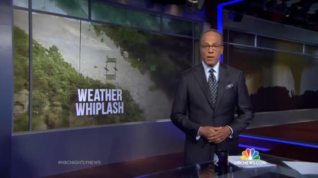
“Weather Whiplash” Promises To Bring More Dangerous Extremes. Where have you heard that before? Here’s a link to a segment on Thursday night’s edition of the NBC Nightly News: “Scientists say climate change is exacerbating the wild weather swings amid a year of historic floods, fires, tornadoes, snow and ice across the U.S.”
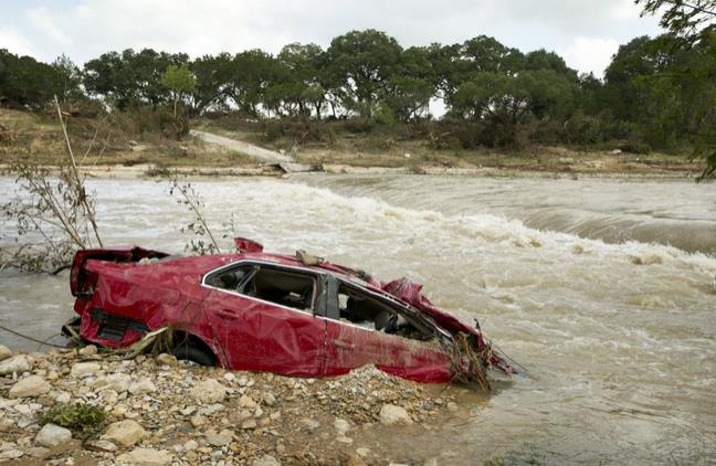
Texas Rains In Keeping With Climate Change. Here’s an excerpt of a statement from The Union of Concerned Scientists: “…Below is a statement by Brenda Ekwurzel, senior climate scientist at the Union of Concerned Scientists. “Around the world, April ocean temperatures have broken records. The Gulf is no exception. The hot Gulf waters combined with a brewing El Nino have contributed to some of the intense precipitation in Texas and beyond. “In addition, because a warmer atmosphere holds more water, climate change means that when it rains it’s more likely to pour. In Texas, the heaviest rainfalls have increased more than 16 percent over the long-term average. This trend will only increase as temperatures rise even more...”
Photo credit above: “A destroyed car is submerged in the Blanco River in Wimberley, Texas, after the flood on Tuesday May 26, 2015.” (Jay Janner/Austin American-Statesman/TNS).
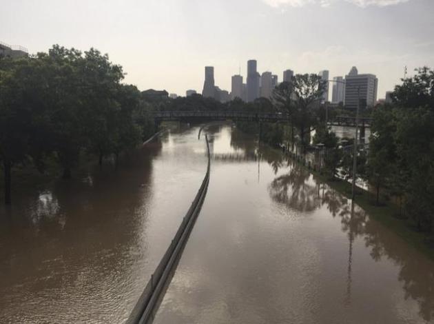
Climate Change, A Factor in Texas Floods, Largely Ignored. Here’s a clip from a story at The Texas Tribune: “…Extreme weather events, and more of them, are among the most agreed-upon effects of global warming in all the scientific literature on the subject, said Nielsen-Gammon, who is also a professor at Texas A&M University. Part of the explanation is that ocean temperatures are rising, bringing more moist air into the state that can create storm systems. In the past century, precipitation in Texas is up 7 to 10 percent, and the frequency of two-day heavy rainfall spells has nearly doubled…”
Photo credit above: “A photo provided by the Harris County Flood Control District shows flood waters covering Memorial Drive along Buffalo Bayou in Houston, May 26, 2015. The heavy rains have killed at least eight people in Texas and Oklahoma, including two in Houston where flooding turned streets into rivers.” (Harris County Flood Control District via The New York Times).
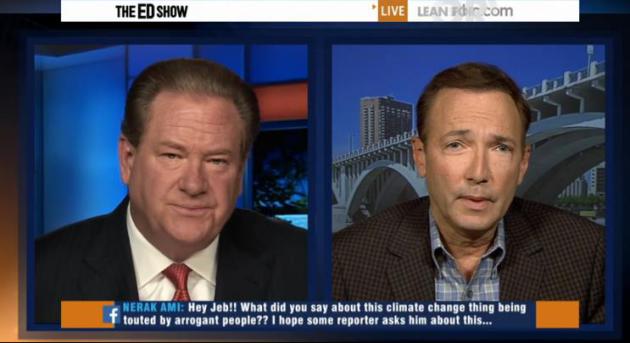
“A Weather and Climate Trifecta”. On Wednesday I had a chance to chat with Ed Schultz on his MSNBC Show (ironic that he was sitting in Detroit Lakes and I was at an uplink facility in Minneapolis) and he asked me to try and put the Texas flooding into context. How much is natural variability vs. thumbprints of climate volatility. The entire 7 minute segment is here.
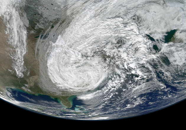
Forecasters Predict “Below Average” 2015 Hurricane Season – But Threats Still Lurk. Where will they form, where will they go? In spite of all our technology there is no way to answer that question. Here’s an excerpt of a story at TIME: “…It’s also important to remember that a storm doesn’t necessarily have to be powerful in order to wreck a lot of havoc. Superstorm Sandy wasn’t technically strong enough to be rated as a hurricane when it made landfall in New Jersey on Oct. 29, 2012—yet it caused north of $60 billion in damage because of its sheer size and because it squarely hit some richest, most populated coastal territory in the U.S. There’s no way to predict today where any hurricanes that may form in 2015 could make landfall—and location matters as much as strength...”
Image of 2012 Superstorm Sandy courtesy of NASA.
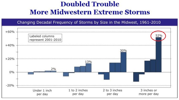
Extreme Rainfall Events On The Rise. It’s not just Texas and Oklahoma, it’s New England, and much of the Upper Midwest. Here’s an excerpt of a story based on research conducted by The Rocky Mountain Climate Organization: “…New RMCO analysis of a half century of precipitation data across the Midwest, defined as Illinois, Indiana, Iowa, Michigan, Minnesota, Missouri, Ohio, and Wisconsin, indicates the region has had an increasing number of large storms since 1961. The largest of storms—those of three inches or more of precipitation in a single day—have increased the most, with their annual frequency more than doubling over the past 51 years. The frequencies of all large storms, especially the largest, have particularly spiked this century…”
Graphic credit above: “Changes in frequencies of storms in the Midwest, by category of storm size for five decades, 1961-1970 through 2001-2010. Labeled changes are for the last decade. Comparisons are to frequencies in 1961-1990.”
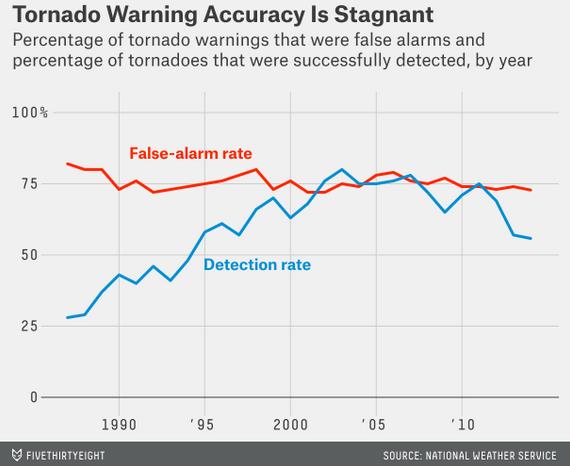
3 Out Of Every 4 Tornado Warnings Are False Alarms. Strongly rotating storms in an environment that’s ripe, primed for tornadoes, is usually enough for a warning to be issued. But only 1 in 4 warnings will produce an actual tornado touchdown – this can lead to resentment, and apathy, when a real tornado does, in fact, materialize. The problems are discussed in a solid article at FiveThirtyEight; here’s an excerpt: “...I think it points to the fact that we still have a long way to go,” said Greg Carbin, a warning coordination meteorologist at the agency’s Storm Prediction Center in Norman, Oklahoma. “You don’t want to miss the bad events. Even in the event where we’re wrong several times, you would rather have a warning out there and have it miss than have an event and not have one out there.” This has been the case for decades. Forecast verification data from the weather service over the past two decades shows that for all the advances technology has provided to forecasting, the agency has made only a relatively small dent in how often it’s wrong when issuing a tornado warning (from 80 percent in 1989 to 72 percent in 2014)...”
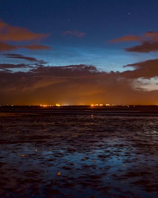
Noctilucent Clouds Glow High Above Scotland. Spaceweather.com has an interesting post about these mysterious high-level clouds that can rarely be seen in the skies over Minnesota; here are a couple of excerpts: “…The northern summer season for noctilucent clouds (NLCs) is underway. Earth-orbiting satellites such as AIM and the International Space Station have been photographing the electric-blue clouds for days. Last night, sky watchers on Earth saw them, too. M. J. S. Ferrier sends this picture from Barassie Beach in Ayrshire, Scotland…NLCs are Earth’s highest clouds. Seeded by meteoroids, they float at the edge of space more than 80 km above the planet’s surface. The clouds are very cold and filled with tiny ice crystals. When sunbeams hit those crystals, they glow electric-blue...”

Internet Trends: 2015. Here is Mary Meeker’s latest overview of global trends, courtesy of Kleiner, Perkins, Caufield Byers in Silicon Valley. There are a few amazing nuggets buried in here.
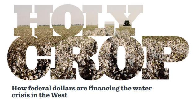
Holy Crop. How Federal Dollars Are Financing The Water Crisis In The West. ProPublica has a long, detailed and vaguely infuriating story about how “incentives” are making the western drought even worse; here’s an excerpt: “…The water shortages that have brought California, Arizona and other Western states to the edge of an environmental cliff have been attributed to a historic climate event — a dry spell that experts worry could be the worst in 1,000 years. But an examination by ProPublica shows that the scarcity of water is as much a man-made crisis as a natural one, the result of decades of missteps and misapprehensions by governments and businesses as they have faced surging demand driven by a booming population. The federal subsidies that prop up cotton farming in Arizona are just one of myriad ways that policymakers have refused, or been slow to reshape laws to reflect the West’s changing circumstances…”

The Most Predictable Disaster In The History Of The Human Race. Of course we’re talking about pandemic, something Bill Gates is very worried about. Here’s a link to an interview and story from Vox: “…Look at the death chart of the 20th century,” he says, because he’s the kind of guy that looks at death charts. “I think everybody would say there must be a spike for World War I. Sure enough, there it is, like 25 million. And there must be a big spike for World War II, and there it is, it’s like 65 million. But then you’ll see this other spike that is as large as World War II right after World War I, and most people, would say, ‘What was that?'” “Well, that was the Spanish flu…”

Can Sunscreen Keep Your Skin From Aging? The short answer appears to be yes. More details courtesy of Next Avenue: “Sunscreen season has arrived, along with guidelines for what actually constitutes defense from solar rays and new evidence that a daily slathering may not only protect you from skin cancer and sunburn, it may keep your skin from aging. That discovery comes from a study published in the journal Annals of Internal Medicine…”

“Saver” Lets People Breathe While Escaping Fires. Why didn’t I think of that? Here’s a snippet from an explanation at gizmag.com: “While a smoke detector can certainly provide you with an early warning in the event of a house fire, it can’t usually do much to help you get out of the building once that fire is underway. That’s why Toronto-based startup Safety iQ developed the Saver. It’s a portable device that reportedly allows users to breathe safely in smoke-filled environments, while also serving as a flashlight and alarm…”

Waking Up To Your Favorite Aroma? I still don’t have my flying car or robotic butler that does all the stuff I don’t want to do, but in the very near future I can wake up to the smell of sweet peach. What about pan-friend walleye? Here’s a clip from a story at Gizmag: “…Users can set their wake up time and load it up with a purpose-made capsule to have it emit an aroma of their choosing in the morning. Among the available smells are espresso and hot croissant, sweet peach, strawberry candy, ginger and pepper mint. These capsules have been developed with Swiss fragrance manufacturer Givaudan and should last 60 uses each...”
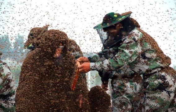
Man Wears Suit Made of 1.1 Million Bees in Attempt To Set World Record. After reading this story at Huffington Post I’m feeling a little better about myself; here’s a shudder-inducing excerpt: “…Beekeeper Gao Bingguo, 55, of east China’s Shandong province, succeeded on Monday in his effort to set a world record for wearing the heaviest coat of bees. His accomplishment was confirmed by officials from Carrying The Flag World Records, according to The Associated Press…” (Image: Imaginechina/Corbis).
TODAY: Showers and T-storms. Winds: NE 10-15. High: 76
FRIDAY NIGHT: Showers taper, turning breezy and cooler. Low: 49
SATURDAY: Blue sky, less humid. Dew point: 39 Winds: N 15. High: 62
SUNDAY: Fading sun, late shower. Winds: SE 10-15. Wake-up: 46. High: 68
MONDAY: Some sun, milder breeze. Wake-up: 52. High: 74
TUESDAY: Sticky sun, isolated T-storm. Wake-up: 60. High: 81
WEDNESDAY: Muggy, few T-storms. Dew point: 62. Wake-up: 62. High: 83
THURSDAY: More numerous T-storms. Wake-up: 65. High: 81
Climate Stories….
Walker’s Denial of Climate Change is Extreme, Heartbreaking. Here’s an excerpt of an Op-Ed from columnist Jim Hightower at LaCrosseTribune.com: “…Symptoms include an obsessive impulse to deny that human-caused climate change is happening, often accompanied by a feverish insistence that government employees be banned from discussing it. Wisconsin Gov. Scott Walker is suffering from this affliction. The Koch-funded governor and Republican presidential wannabe is an ardent climate-change denier. And his state’s public lands board has taken climate denial to Orwellian levels...”
File photo above: AP/The Des Moines Register, Charlie Litchfield.

Experts Warn Climate Change Affecting Tick Population. It’s another bad year for ticks. A friend recently pulled 236 ticks off his dog after about an hour in the woods. Unreal. The trends in Minnesota are similar to other northern tier states, including Maine, where WMTW-TV in Augusta produced this video and story; here’s a clip: “…Elias said the warmer and wetter the climate is, the more ticks there are. “We have seen a steady increase in the number of ticks in the state of Maine, starting in 1989, and we do have fluctuations from one year to the next, but there is clearly an upward and sharp trend in the number of deer ticks,” Elias said. Experts said that is a problem because ticks carry a number of diseases, including Lyme disease. “The concern is that certainly last year we had 1,400 cases of Lyme disease, as well as other co-infections, as we call them, and some other tick-borne pathogens,” said Jim Dill, of the University of Maine Cooperative Extension...”

If You’ve Wondered Why So Many Politicians Deny Climate Change, Science Has Your Answer. Because people just want to fit in and be accepted by members of their “tribe”. I wish I had a tribe. Here’s an excerpt from ThinkProgress: “…But according to new research published in Nature Climate Change, there’s at least one statistically proven reason why more than 56 percent of Congressional Republicans deny climate change: echo chambers. The term “echo chambers” traditionally refers to situations where people surround themselves with information they want to hear, and block out the rest. We’ve known for a while that these present themselves in climate politics; A 2014 study suggested that the reason Americans haven’t fully accepted the scientific consensus on climate change is because of echo chambers like Fox News, where conservative viewers are “exposed only to content consistent with their opinions, while shielded from dissenting views…”
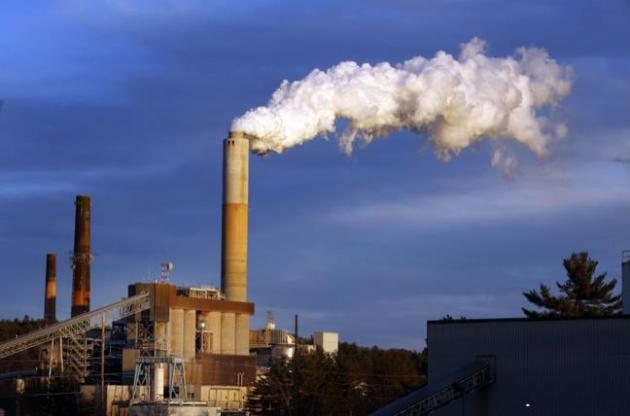
Norway’s $900 Billion Sovereign Fund Told To Reduce Coal Assets. Reuters has the details; here’s a link and excerpt: “Norway’s $900 billion sovereign wealth fund, the world’s largest, should cut its exposure to the global coal industry and sell stakes in firms that focus on the sector, a key parliamentary committee said on Wednesday. The finance committee agreed in a bipartisan motion that the fund, which owns about 1.3 percent of all listed companies globally, should sell stakes in firms that generate more than 30 percent of their output or revenues from coal-related activities...”
File photo above: “In this Tuesday Jan. 20, 2015 file photo, a plume of steam billows from the coal-fired Merrimack Station in Bow, N.H. The Obama Administration’s hotly debated plan to cut the amount of heat-trapping carbon dioxide coming out of the nation’s power plants will save about 3,500 lives a year from also reducing other types of pollutions, a new independent study concludes.” (AP Photo/Jim Cole, File)

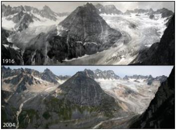
Norwegian Monarch Visits Anchorage; Urges Action on Climate Change. Alaska Public Media has the story; here’s a snippet: “The King of Norway visited Anchorage on Wednesday bearing a message of goodwill, and the message that climate change is a priority for all Arctic nations. After visiting the Anchorage Museum, the Norwegian monarch, King Harald V, spoke at a luncheon hosted by the Alaska World Affairs Council, where he urged the value of science and study in the far north…”
Image credit: “King Harald V of Norway.”
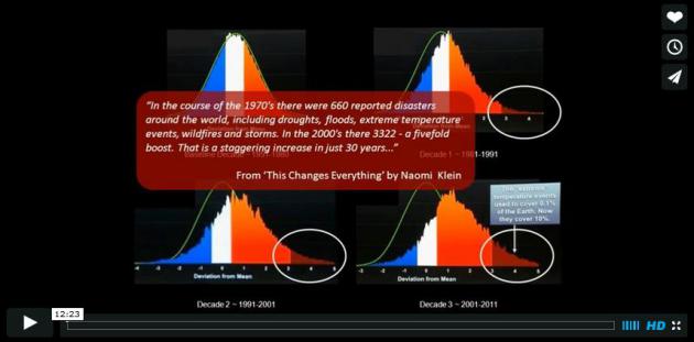
Extreme Weather Trends. Here’s more data and perspective on severe weather trends from Bru Pearce at Vimeo: “This presentation uses temperature data over three decades ending in 2011 to demonstrate the exponential nature of climate change and shows that climate change is now accelerating in an extremely dangerous way.”