63 F. high in the Twin Cities Monday.
68 F. average high on May 12.
59 F. high on May 12, 2013.
.23″ rain fell yesterday at KMSP.
11.51″ precipitation so far in 2014.
7.54″ average precipitation, to date, as of May 12.
10.30″ precipitation fell as of May 12, 2013.

Siren Song
I received an e-mail from Sue Bailey in St. Paul, expressing confusion over when the sirens are supposed to sound in Washington County. Yes, the criteria varies from county to county in the metro. So I asked local expert, Todd Krause, at the Twin Cities National Weather Service.
“Five of the seven counties have agreed on the same criteria: tornado warnings or 70+ mph wind. The sixth county, Anoka, activates only for tornado warnings, and the seventh, Dakota, activates for all tornado and severe thunderstorm warnings.”
Bottom line: there is considerable discretion from county to county on when to blow the sirens. Local Civil Defense activates the sirens, not the National Weather Service or local meteorologists.
But as I’ve said (ad nauseum) over the years – if you rely entirely on sirens (which were designed for outdoor use only) you’re putting your family at risk. The more sources of warning information, the better.
It will be too cool and stable for raging storms this week; a flashback of mid-April with highs in the 50s & scrappy clouds. Once again a storm stalls out east, keeping us in a dry, cool, Canadian flow into late week. Showers pop up Thursday but this week looks mostly dry.
Spring comes bouncing back next week with 70s, even a few 80s and scattered T-storms. Will it hold for Memorial Day?
Light a candle.
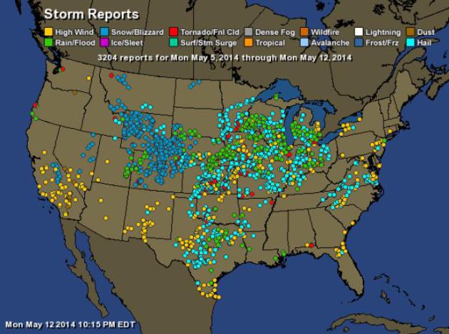
1 Week’s Worth of Severe Storm Reports. From heavy snow in Wyoming and Colorado to high winds in California to blowing dust over the southern Plains and flooding rains across the Midwest (green dots) and scattered tornadoes (displayed as red dots above), it was another wild week of weather; over 3200 severe storm reports according to NOAA. Map: HAMweather.
| Total Storm Reports: | 3204 |
| Wind: | 680 |
| Rain: | 411 |
| Snow/Blizzard: | 663 |
| Ice: | 1 |
| Tornado: | 98 |
| Hail: | 1331 |
| Lightning: | 4 |
| Dust: | 10 |
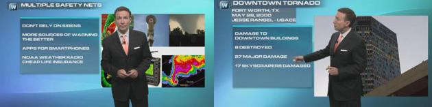
Downtown Tornadoes: What To Do If You’re In A High-Rise. We’ve devoted considerable attention to what you can do to lower risk if you don’t have a basement or storm shelter, but what if you’re caught in an office tower or downtown condo? There are steps you can take to dramatically lower the risk. We also dispel a nagging myth: tornadoes can’t hit cities. It’s happened repeatedly over the years, from Salt Lake City to Oklahoma City, Chicago, Louisville, Worcester, MA, even Miami. St. Louis has been struck 4 times in just the last century. Those are the topics of today’s Climate Matters segments: downtown tornadoes, and tornado safety for high-rise buildings.
* EF-1 tornadoes just hit metro Omaha. Details from WOWT-TV.
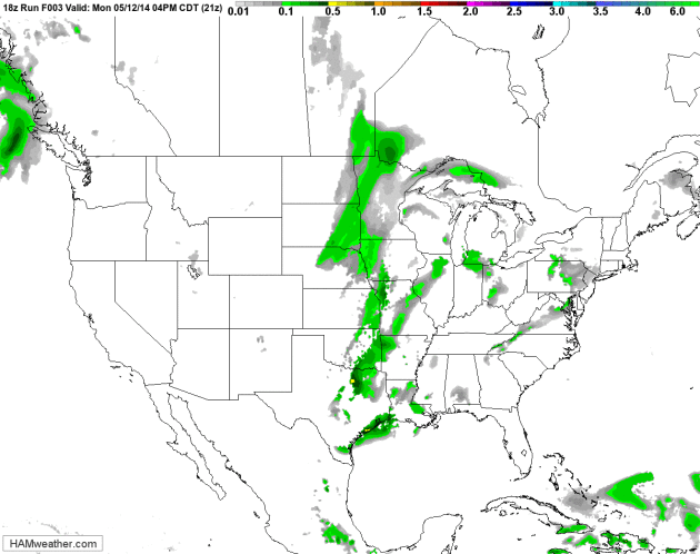
Slow-Motion Weather Map. Once again a storm is about to “cut-off” from the main belt of westerlies, prolonging drenching rains from the Lower Mississippi Valley up the Appalachians by late week, resulting in some 2-5″ rainfall amounts with flash flooding. It’s a tale of the moisture-haves out east, and the moisture-have-nots west of the Rockies. NAM Future Radar courtesy of NOAA and HAMweather.
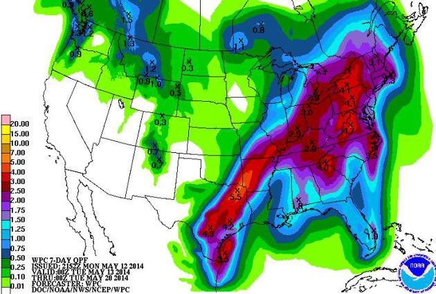
7-Day Rainfall. NOAA guidance shows potentially torrential rains from Dallas and Little Rock to Louisville, Indianapolis and Pittsburgh as a very slow-moving storm limps across the eastern USA. Meanwhile brushfires continue to burn from Texas and New Mexico into Arizona; most of the Southwest remains bone-dry.
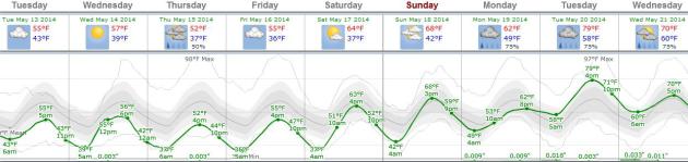
A Cool, Dry Break in the Pattern. Yes, it will look and feel more like mid-October than mid-May, but you can’t have everything, at least not all at once. Temperatures run about 10-15F cooler than average into Friday, with a few spotty instability showers Thursday afternoon. Readings mellow into the 60s over the weekend; I suspect we’ll see a few 70s next week with a rerun of heavy T-storms. But 5-6 (mostly) dry days in a row? Take full advantage of this break in the conga-line of storms to get out into your fields or gardens. Graphic: Weatherspark.
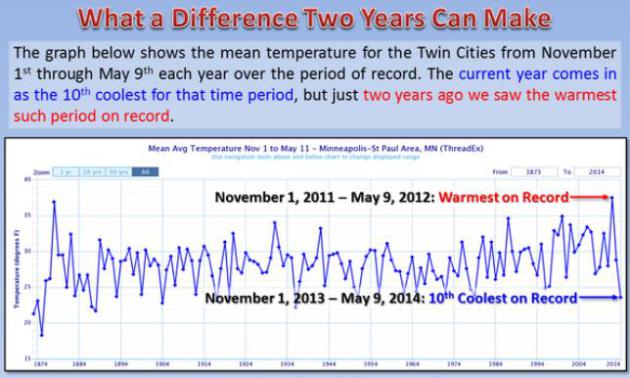
Wild Swings. The Twin Cities office of the National Weather Service shows how the MSP metro area swung from the warmest 7 month period in late 2011 and early 2012 to the 10th coldest such period in late 2013 and early 2014. Serious weather whiplash.
More Jaw-Dropping Extremes across the USA:
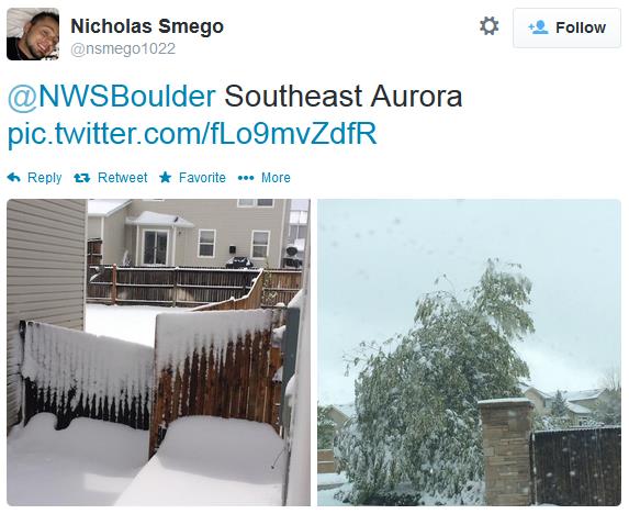
What May? It still looks like early March in the suburbs of Denver and Boulder, including Aurora, where heavy wet snow damaged trees (and depressed even the ski buffs). Source: Twitter.
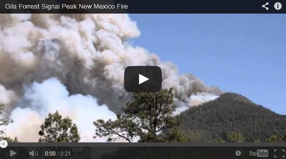
New Mexico Wildfire Forces Evacuations, Threatens College Town. Here’s an excerpt from a story at Reuters: “A wind-fed wildfire in New Mexico raged out of control on Monday, sending heavy smoke wafting over the outskirts of a college town and forcing local authorities to warn residents of a nearby community to evacuate, the U.S. Forest Service said. The so-called Signal Peak Fire has burned 3,000 acres since erupting on Sunday in the Gila National Forest, fed by tinder-dry conditions and high winds, with gusts exceeding 25 miles per hour, according to U.S. Forest Service spokesman Brian Martinez...”
Video and story courtesy of wildfiretoday.com.
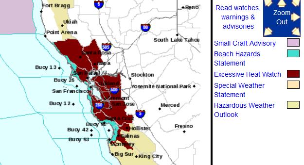
Excessive Heat Watch for Bay Area. While residents of Colorado shovel away snow and slush, the heat is building out west, increasing the potential for brushfires and water shortages. Here’s an excerpt of the Excessive Heat Watch issued by NOAA:
BUILDING HIGH PRESSURE WILL BRING RECORD OR NEAR RECORD HEAT
TUESDAY AND WEDNESDAY. TEMPERATURES WILL WARM TO ABOVE NORMAL TODAY
THEN CONTINUE TO RISE TUESDAY AND WEDNESDAY UNDER MOSTLY SUNNY
SKIES. PERIODS OF OFFSHORE WINDS WILL ALLOW WARM TO HOT TEMPERATURES
TO REACH ALL THE WAY TO THE COAST. PERSONS SENSITIVE TO HEAT SUCH
AS THE ELDERLY AND THOSE ON CERTAIN MEDICATIONS SHOULD PLAN
ACCORDINGLY AND PUT A PLAN IN PLACE NOW TO PREPARE FOR THE
UPCOMING HOT WEATHER. SOME COOLING MAY OCCUR NEAR THE COAST BY
THURSDAY WHILE HOT WEATHER CONTINUES INLAND. MORE COOLING IS
FORECAST FOR ALL LOCATIONS BY FRIDAY.
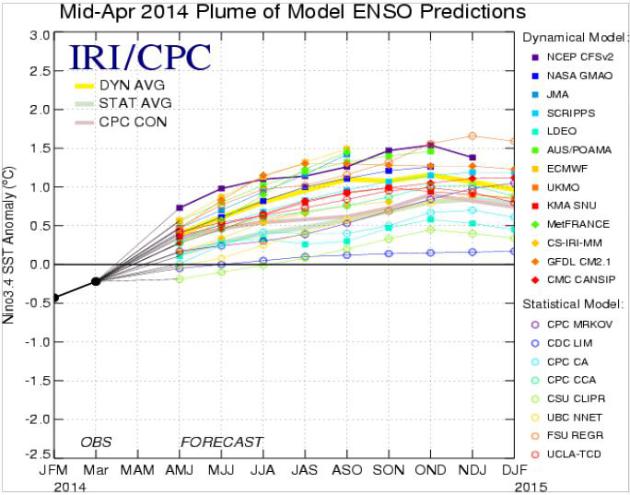
Probability of El Nino Rises to 65% Here is potentially more than you ever wanted to know about the developing El Nino phase of ENSO, a warming of Pacific Ocean water which will probably influence weather patterns the latter half of 2014, possibly into early 2015. Details from NOAA.
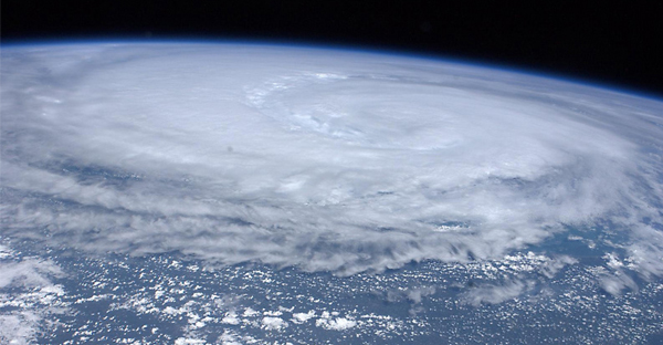
Hurricane Season Forecast Making Its New York City Debut. Usually meteorologists with the National Hurricane Center make their predictions from south Florida, but this year, paying respect to the aftermath of Sandy, they will report from Brooklyn. Here’s an excerpt from sun-sentinel.com: “…The NOAA news conference will be held in Brooklyn, home of the New York City Emergency Operations Center. “We usually host the press conference on location somewhere that makes sense,” Buchanan said. Usually, that’s storm-prone South Florida or NOAA headquarters in Washington, D.C…”
Ask Paul. Weather-related questions, comments and threats:
Hello,
I had a quick question – I was looking at radar images of the storms that moved through the central part of the country Sunday night. The returns showed echo tops at 70,000 feet, and another at 69,000 feet! How common is it to see storms that reach that high? As a pilot, I pretty regularly keep up with radar and I had never seen tops that high before. I’ve attached a screenshot of the radar returns.
Thanks!
Geoff Zahn
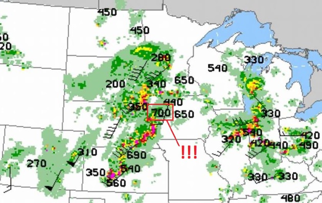
Geoff – you are correct. Some of the anvil tops with the severe storms that swept across Nebraska, Kansas and Iowa extended as high as 65,000 to 70,000 feet, into the stratosphere. It’s a measure of the intensity of the updrafts within these severe, tornado-producing supercells. Most thunderstorms extend up to 45,000 to 55,000 feet, but I can’t recall (ever) seeing a top to 70,000 feet.
My co-workers and I have been discussing the activation of sirens and what they mean. I talked to the Chief of Police in St. Paul Park, and was told that Washington County only activates the sirens when there is a tornado. Some of us believe that sirens are now activated during a severe thunderstorm warning as well. Can you please provide us with the criteria for the counties in the metro area. I heard two types of sirens on Wednesday night, the first siren activated started low and went to high and stayed high, an hour later, the siren went from low to high several times before it stopped. Any guidance you can provide would be appreciated. Thank you for your time.
Sue Bailey
Saint Paul, MN
Sue, I am just as confused as you are. The truth: criteria for sounding the sirens varies from county to county, and it’s at the discretion of the local Civil Defense authorities who are the ones actually activating the sirens. In a perfect world it would be the same, all across the 7-county metropolitan area. But different communities have different thresholds for alerting their residents, as described below:
Hi Paul,
Five of the seven counties have agreed on the same criteria: tornado warnings or 70+ mph wind. The sixth county (Anoka) activates only for tornado warnings, and the seventh (Dakota) activates for all tornado and severe thunderstorm warnings. Most of them (including Dakota) look at the polygons to decide where sirens should be activated. I hope this helps.
Todd Krause, Warning Coordination Meteorologist, Twin Cities National Weather Service

10 Tornado Safety Tips To Keep You Safe Before, During And After A Storm. Here is an excerpt of a good recap of what to do and not to do during a tornado outbreak, courtesy of protect-your-home.org: “…If no shelter is available:
- Are you indoors? Go to the lowest floor, to a small, center interior room, under a stairwell or to an interior hallway with no windows.Crouch down as low as possible to the floor, face down and cover your head with your arms. Cover yourself with a blanket, mattress, helmet or other thick covering. Wear footwear with thick soles to your safe location.
- Are you in a mobile home? Get out. Even if your home is tied down, it is not as safe as a sturdy building. Go to a nearby permanent structure…”

Local Physics Professor Creates Tornado Detector Prototype. KY3 has the story – here’s a clip: “…The device creates these warnings based on measurements of wind velocity and barometric pressure in the atmosphere. Dr.Redd says it can be used in residential settings in addition to existing public warning systems like tornado sirens and radar. “It’s going to be more useful out in rural areas. It’s going to be more useful in small towns that are remote form the radars because the radar has a horizon problem,” said Redd…”

Poll: Prestigious Colleges Won’t Make You Happier In Life or Work. NPR has the rather surprising details; here’s an excerpt: “There’s plenty of anxiety in the U.S. over getting into a top college. But a suggests that, later in life, it doesn’t matter nearly as much as we think. In fact, when you ask college graduates whether they’re “engaged” with their work or “thriving” in all aspects of their lives, their responses don’t vary one bit whether they went to a prestigious college or not…”

Apple To Unveil iPhone 6 In August, Earlier Than Expected: Report. Bloomberg has the details; here’s an excerpt: “…A 4.7-inch screen version of the iPhone 6 will reach stores in August, the Economic Daily News reported without specifying which markets would receive the phone first. A 5.5-inch or 5.6-inch model will be released in September, the newspaper said, as the iPhone 5 series was previously...”
File photo: AP Photo/Ahn Young-joon.
TODAY: Sunny intervals, clouds build by afternoon, cool breeze. Winds: NW 15+ High: 57
TUESDAY NIGHT: Partial clearing, chilly for mid-May. Low: 39
WEDNESDAY: More clouds than sun, brisk. High: 56
THURSDAY: Mayday! Clouds, few PM showers. Wake-up: 38. High: 53
FRIDAY: AM sunshine, PM clouds, still cool. Wake-up: 37. High: 58
SATURDAY: Partly sunny, some temperature recovery. Wake-up: 39. High: 64
SUNDAY: Plenty of sun, feels like May again. Wake-up: 41. High: 68
MONDAY: Warmer and more humid, few T-storms nearby. Wake-up: 49. High: 72
Climate Stories….
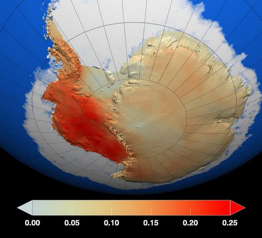
Scientists Warn of Rising Oceans as Antarctic Ice Melts. I can tell you from first-hand experience that this report, highlighted in Nature, has many climate scientists more alarmed than I’ve seen them in a long time. Justin Gillis at The New York Times has a good summary; here’s an excerpt: “The collapse of large parts of the ice sheet in West Antarctica appears to have begun and is almost certainly unstoppable, with global warming accelerating the pace of the disintegration, two groups of scientists reported Monday. The finding, which had been feared by some scientists for decades, means that a rise in global sea level of at least 10 feet may now be inevitable. The rise may continue to be relatively slow for at least the next century or so, the scientists said, but sometime after that it will probably speed up so sharply as to become a crisis…”
Graphic credit above: “In this graphic, the red regions are areas where temperatures have increased the most during the last 50 years, particularly in West Antarctica, The dark blue regions have had a lesser degree of warming. Temperature changes are measured in degrees Celsius [per decade].” Credit NASA/GSFC Scientific Visualization Studio.
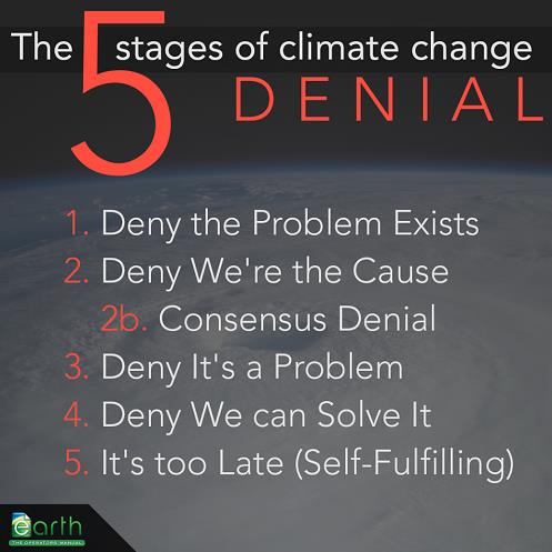
5 Stages of Climate Denial. Thanks to Shauna Theel for passing this one along.
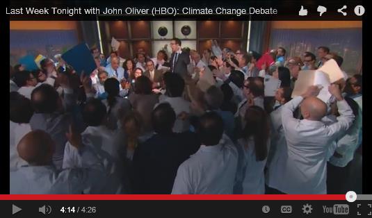
The “Climate Debate” on TV: John Oliver Gets It Exactly Right. Could it be that 1 in 4 skeptical Americans are….wrong about science? Not sure, but it seems hypothetically possible. Here’s a funny, yet dead-on summary of the “debate” from John Oliver at “Last Week Tonight with John Oliver” on HBO, courtesy of SayWhat? “So many earnest words have been written trying to say what John Oliver says here. I have yet to see anyone make this point any clearer. Dead on, plus hysterical.” [rated PG]
