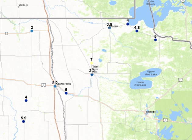
Snowfall Totals Through 6 PM Monday

Through the early evening hours Monday, snow totals had only been reported across parts of northwestern Minnesota. The highest total was 7″ in Holt, which is north of Thief River Falls. You can view this interactive map from the NWS by clicking here.
_______________________________________________
Record Breaking Monday In The Twin Cities
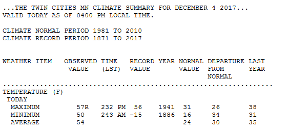
Before the cold front moved through Monday, we saw a record high of 57 during the afternoon hours in the Twin Cities, beating the previous record of 56 in 1941.
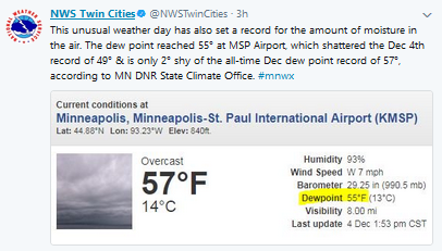
We also saw a record high dew point today in the Twin Cities of 55, falling two degrees shy of the all-time December record.
_______________________________________________
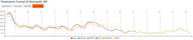
Expected Snow Totals, Wind Gusts Monday Night
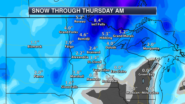
Here are the expected snow totals through the middle of the week, most of which will fall during this storm before it pushed out Monday Night and Tuesday. Parts of northern Minnesota are expected to receive over a half a foot of snow.

Winds will continue to be quite gusty as we head through Monday Night, with peak wind gusts nearing 50 mph in western Minnesota. Even here in the Twin Cities we will see wind gusts topping 45 mph. Windy conditions will continue into Tuesday, along with much colder air filtering into the state. I have more on the forecast for tomorrow – and beyond – below.
_______________________________________________
Winter Is Here – Windy, Cold Tuesday Ahead
By D.J. Kayser, filling in for Paul Douglas
Welcome back, winter. I, for one, didn’t miss you much. I guess it’s time to grab the warm pajamas out from the back of the closet!
Meteorologically speaking, winter started a few days ago on December 1st. That marks the beginning of the coldest three months of the year for the Northern Hemisphere. While the first three days of December certainly didn’t feel like winter, with the average temperature 14.5 degrees above average, Old Man Winter has returned with a vengeance reminding everyone what season it really is.
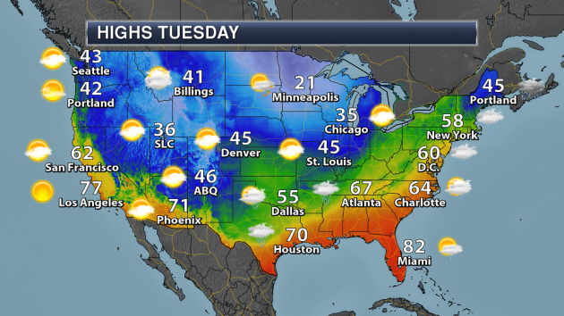
A few snowflakes will be possible today, but the main story behind our early week system will be the cold air and blustery winds for your Tuesday. Winds gusting up to 30 mph throughout the day will make highs in the low 20s feel more like the single digits. We’ll stay cold this week, with another reinforcing shot of Canadian air late this week that’ll bring another chance of snow with it.
Look toward the bright side – we’re just six months away from meteorological summer. Maybe that thought will help keep you warm until then!
_______________________________________________
Extended Twin Cities Forecast
TUESDAY: PM flurries. Feels like 5F. High 21. Low 14. Chance of precipitation 20%. Wind W 15-25 mph.
WEDNESDAY: Mix of sun and clouds. High 22. Low 9. Chance of precipitation 0%. Wind NW 10-20 mph.
THURSDAY: Increasing clouds. Late day flurries. High 21. Low 12. Chance of precipitation 30%. Wind NW 5-10 mph.
FRIDAY: Scattered snow showers. High 23. Low 10. Chance of precipitation 30%. Wind NW 5-15 mph.
SATURDAY: Decreasing clouds. Slightly warmer. High 26. Low 14. Chance of precipitation 0%. Wind NW 5-10 mph.
SUNDAY: Cloudy skies. Temps around freezing. High 31. Low 23. Chance of precipitation 0%. Wind SW 5-15 mph.
MONDAY: A few passing snow showers. High 27. Low 9. Chance of precipitation 30%. Wind NW 10-15 mph.
_______________________________________________
This Day in Weather History
December 5th
2001: An unseasonably warm December day occurs, with a high of 63 degrees at the Twin Cities. Summer-like thunderstorms developed and dropped quarter-sized hail at the Eyota Post Office in Olmsted County.
1979: Mild air moves in to Minnesota, with highs of 52 at St. Cloud and 54 at Browns Valley.
1928: Canby receives three inches of snow or greater for the third consecutive day.
_______________________________________________
Average Temperatures & Precipitation for Minneapolis
December 5th
Average High: 30F (Record: 63F set in 2001)
Average Low: 16F (Record: -14F set in 1873)
Average Precipitation: 0.04″ (Record: 0.81″ set in 1909)
Average Snow: 0.4″ (Record: 7.0″ set in 1909)
________________________________________________
Sunrise/Sunset Times for Minneapolis
December 5th
Sunrise: 7:35 AM
Sunset: 4:31 PM
*Length Of Day: 8 hours, 56 minutes and 12 seconds
*Daylight Lost Since Yesterday: ~1 minute and 15 seconds
*Latest Sunrise: December 30th-January 5th (7:51 AM)
*Earliest Sunset: December 5th-13th (4:31 PM)
________________________________________________
Minnesota Weather Outlook

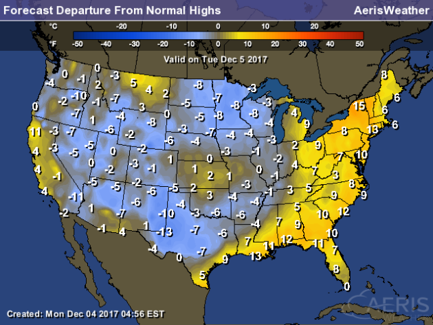
Well, our extended warmth was fun while it lasted. We are back to reality as we head into Tuesday, with highs in the teens and 20s across the state. Some snow will be possible at times, especially across central and northern Minnesota. Blowing and drifting snow may also continue to be a concern as we’ll see blustery conditions.
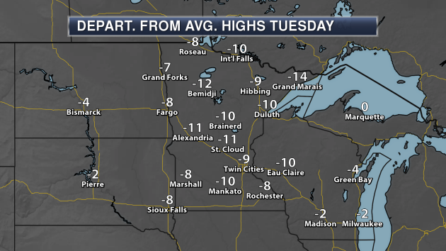
After numerous days of above average weather, we’re finally seeing temperatures that are below average for this time of year by a good 5-15 degrees.
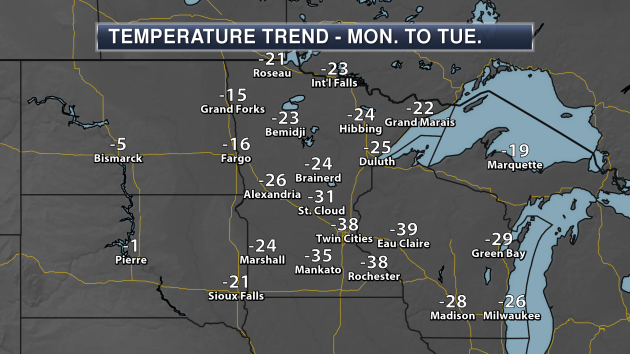
Highs on Tuesday will be almost 40 degrees colder in the Twin Cities versus Monday! This is quite a cold blast of air that is sinking south out of Canada.
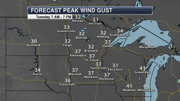
Winds will continue to be gusty during the day Tuesday, peaking in the 30 mph range across most of the state. This could lead to some blowing snow at times, reducing visibilities.
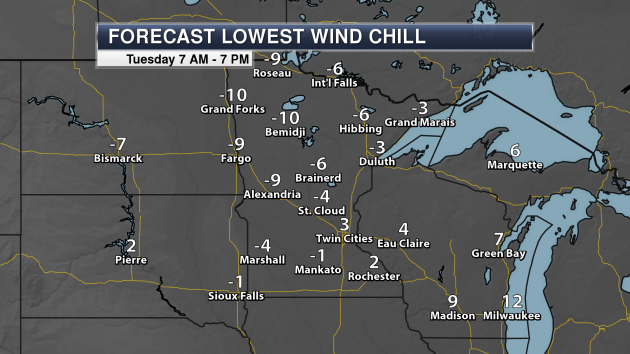
Even though highs will be in the teens and 20s Tuesday, with the strong winds it’ll feel more like the single digits and teens below zero across the state throughout the day – not just during the early morning hours.

Those wind chill will continue to be cold for heading to work or school heading into Wednesday morning as well.
_______________________________________________
National Weather Stories
You can see the initial cold front responsible for our cold down in the upper Midwest continue east into Tuesday, bringing cooler weather from the Great Lakes to Texas. Along the cold front we will see the potential of showers and thunderstorms from the Northeast to the Gulf Coast. Another system will bring the possibility of a few snow showers from Montana into the Dakotas. Snow showers will also be possible across northern Minnesota, as well as downwind of the western Great Lakes due to lake effect snow.
Ahead of the cold front, temperatures will be 5-15 degrees above average from the Gulf Coast to New England. Behind the front, we’ll see below average air sinking in.
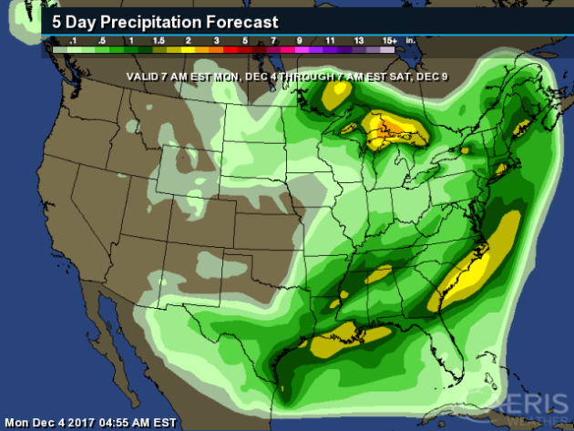
With the cold front moving east the next couple days, some heavy rain will be possible across the eastern and southern United States, with rainfall totals between 1-3″ possible. After a stretch of rainy weather in the Northwest, they will see relatively dry weather this week.
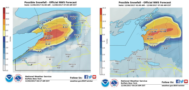
As we head toward the second half of the week, winds will be blowing off of Lake Erie and Ontario, creating the potential of heavy lake effect snow for areas like Buffalo, NY. Snow totals are likely to top a foot in parts of western New York.
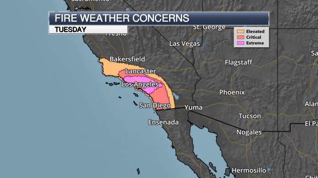
A strong, long duration Santa Ana wind event is unfolding this week across parts of southern California. Some of the strongest winds are expected Tuesday across the mountains, with gusts up to 80 mph possible. This is leading to extreme fire danger in the Los Angeles area over the next few days, including Tuesday.
________________________________________________
Potential Of A Bad Flu Season Ahead

Signs are pointing to the potential of a bad and early flu season this year. Good thing I already got my flu shot for the winter. More from Popular Science: “When it comes to flu season, the only thing we can be absolutely certain of is this: it will happen every year. We are notoriously bad at predicting pretty much everything about influenza, including the timing and severity of the season, so we rely on small clues to try to get ahead of the virus. And so far, this year’s hints are pointing to particularly nasty—and early—flu season. So get your shots now, people.” Image: CDC Weekly Flu Summary Map
No More “Cape Wind” Project
The Cape Wind project, which would have put a wind farm in Nanucket Sound, will no longer happen. More from the Cape Cod Times: “After more than 16 years, tens of millions of dollars spent and seemingly endless, at times deafening, debate, the announcement Friday that Cape Wind is officially dead came quietly by email. “Cape Wind has confirmed to the Bureau of Ocean Energy Management that it has ceased development of its proposed offshore wind farm project in Nantucket Sound and has filed to terminate its offshore wind development lease that was issued in 2010,” according to a statement sent to the Times by Cape Wind vice president Dennis Duffy.”
Climate Change In Anchorage
Leaders of Anchorage, Alaska know what the impacts on climate change could be on their city. One problem: they don’t have money to help combat it. More from The Week and PRI: “Like any coastal city, the impacts of climate change are a concern for Anchorage’s leaders. But in Alaska, the concerns are even more dire. Alaska has warmed more than twice as fast as rest of the country — winters in Anchorage are 6 degrees warmer than they were 70 years ago. And that’s impacting life there in many ways, from commerce to recreation to the city’s ability to take in climate migrants. Consider commerce. The Port of Anchorage is a lifeline for Alaska.”
________________________________________________
Thanks for checking in and have a great Tuesday! Don’t forget to follow me on Twitter (@dkayserwx) and like me on Facebook (Meteorologist D.J. Kayser)!
– D.J. Kayser

