The Winter Outlooks are out… but CAUTION is advised.
Oh can you believe it? Winter is closing in. Fans of Game Of Thrones perhaps would say winter is coming! Eh, that’s a bit too cheesy. In reality, winter really isn’t that far around the corner at this point.
Cheesy and cliché comments aside… let’s take a quick look ahead at this very long range forecasting stuff. Keep in mind, this outlook is NOT completely perfect but it does give us a general idea at what you can expect for winter. There is a lot of model uncertainty and error involved since we are trying to generalize things for an entire 3 month period, across the entire nation. The USA is huge! Forecasting winter for the whole country is a challenge, to say the least.
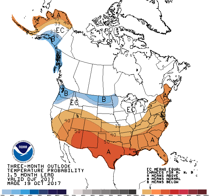
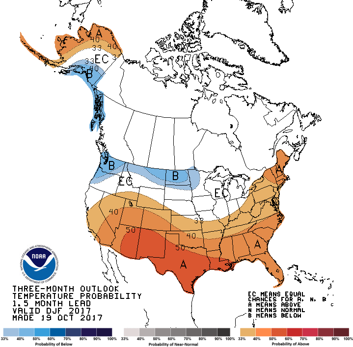
So let’s get down to the nuts and bolts here. NOAA, The National Oceanic Atmospheric Administration recently released their 2017 winter outlook. It shows both the temperature and precipitation outlook for December through February (meteorological winter). You can see both images referencing this below. So here we go!
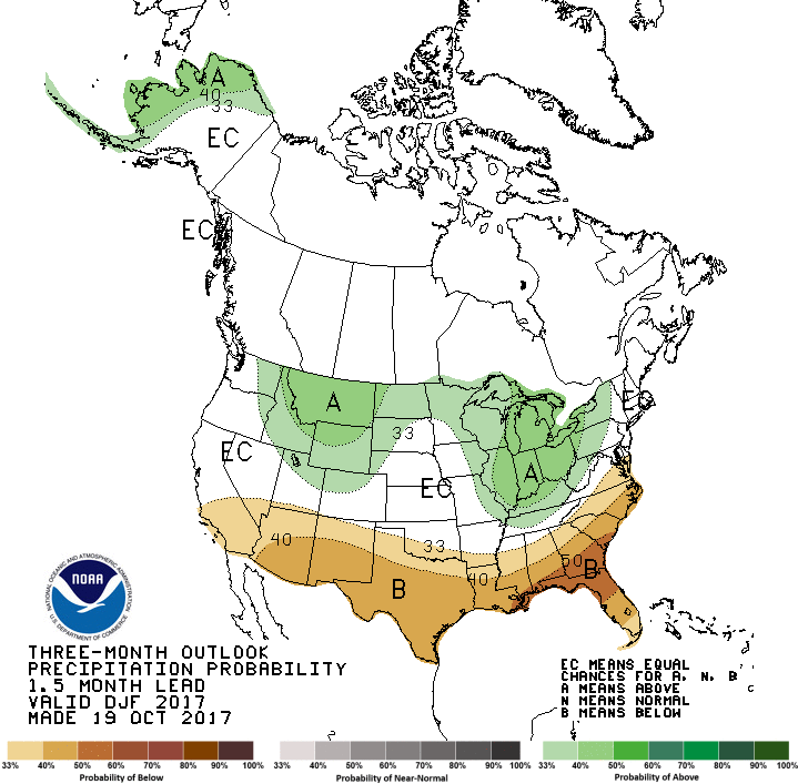
What we can see here are fairly decent chances that portions of the northern lower 48 have a fairly HIGH probability of a COLDER (colored in blue) and WETTER (colored in green) winter. The southern half has a higher chance of a relatively dry (brown) and warm (red) winter. The darker the color on the map, the higher this probability. Interestingly, Alaska is divided warm and wet to the west and cold to the southeast. But that is typical of La Niña!
NOAA and the Climate Prediction Center (CPC) are generally basing much of this on us having a La Niña year… which is what it looks like we’re going to have.
La Niña is characterized by unusually cold ocean temperatures in the Equatorial Pacific, compared to El Niño. In a typical La Nina winter… you have better odds of having WARMER than average temperatures for much of the southern lower 48. It would also be DRIER than average during winter (shown in image below).

It gets a little bit cooler in the portions of the north as that polar jet stream plummets south over North America from that strong high pressure that sets up over the Pacific. A La Niña winter climatologically sees more cold air outbreaks over the Pacific Northwest, Midwest, and Great Lakes regions.
That would influence more flakes flying in the mountains out west. Also, if those cold outbreaks time just right over the Great Lakes… that could mean more wet, lake effect snow events.
Soon enough, we’ll be reaching for the snow shovel, throwing snowballs at our friends, and of course sticking a pipe in Frosty the Snowman! Just be sure to take these outlooks with a grain of salt. Perhaps the same salt you’ll throw on the sidewalk come winter…. eh, that’s cheesy again.
So according to this… Minnesota generally stands to have a colder and wetter than average winter. But take this outlook with a grain of salt.
Significant cool-down looms… & perhaps the 1st snowflakes of the season… maybe???
Yes, you read that right. I encourage you to get all of your collective gasps out of the way now… because there is not a whole lot about the ‘S’ word to get excited about… at least not at this time.
Let’s walk through your Twin Cities metro 7-day forecast, shall we (pictured below)?

Sunday looks fabulous! Highs in the low to mid 60s with plenty of sunshine. Enjoy!
We sneakily get back near 60 degrees or so Monday before a strong and rather chilly NW breeze plummets in from Canada in a hurry. Tuesday settles right near 50 degrees with lows in the chilly 30s Tuesday night. Fall jackets, anyone? A few rain showers are possible Monday night.
Thursday brings a fairly decent chance of rain showers in the afternoon. And then comes the uncertainty to wrap up the week.
I will mention a chance of rain and snow showers as easily the COLDEST air of the season rocks into Minnesota Friday into Saturday. All long term models can agree on the big cool-down coming (not sure if we’ll get as cold as a high of 33 on Saturday though…).
That sun icon you see on Friday is just wrong. We will be watching for chances of rain and snow showers for much of Minnesota Thursday night through Friday night. However… c’mon, dear reader. It is still WAY too early to start talking snow timing and amounts. There’s tons of uncertainty right now. Like me, you’ll have to stay tuned when a more accurate forecast comes out later this week.
I have problems with snowfall forecasts more than one day out of a potential event… much less 5+ days out. It’s still too early to tell if we’ll be shaking the Minnesota snow globe by the end of the week.
– Meteorologist Joe Hansel
Stay classy, fellow weather nerds. Follow me on Facebook & Twitter.