Snowfall Update

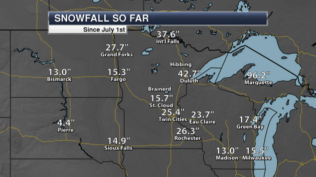
After our snowstorm last Monday in the Twin Cities, we are now above 25″ of snow so far this winter here in the metro. Snow this winter is now topping 26″ in Rochester as well. However, St. Cloud is still sitting at 15.7″ of snow after seeing a grand total of 0.0″ Monday.
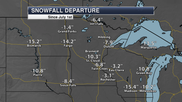
Even with that heavy snow across southern Minnesota, we are still below average for this time of year. Here in the Twin Cities, that is by over a half a foot. Meanwhile, St. Cloud is more than 10″ below average.
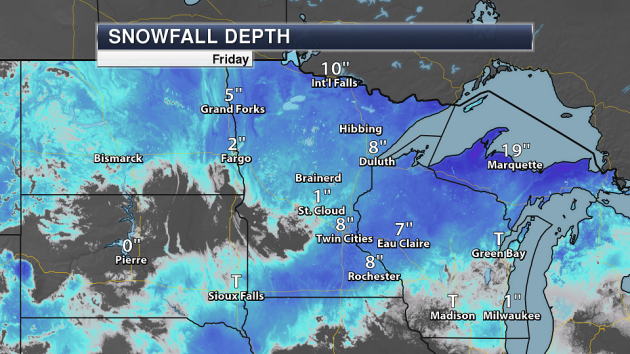
As of Friday morning (before the 47 degree high) we had 8” of snow on the ground in the Twin Cities. You can see little to no snow on the ground across portions of central Minnesota.
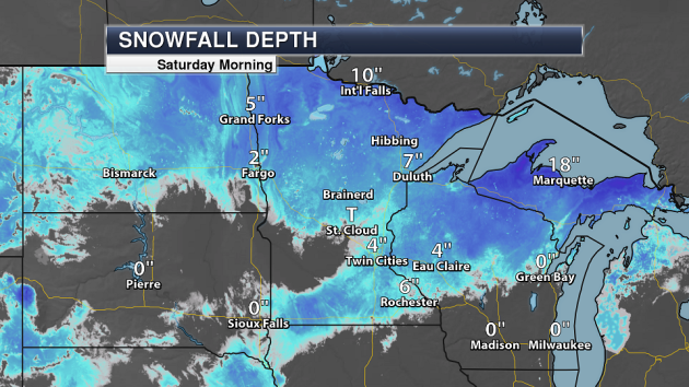
As of Saturday morning, though, there were only 4” of snow on the ground at MSP as we melted away half the snow on the ground due the the warm temperatures to end the week.
_______________________________________________
Abnormally Dry Conditions
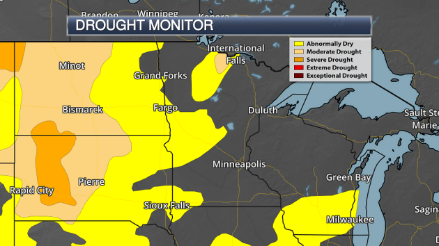
With our lack of snow across a good portion of the state so far this winter, we have seen abnormally conditions start to expand. Last week’s (1/16/18) Drought Monitor had 12.76% of the state under abnormally dry conditions. This week’s (1/23/18) Drought Monitor report had expanded that to cover 27.2% of Minnesota. Meanwhile, 1.37% of the state (up in north-central Minnesota) is under Moderate Drought conditions. We have now seen at least a part of the state under moderate drought conditions since early June, with the peak occurring on 9/12/17 when 21.39% of the state was under moderate drought.
_______________________________________________
Roller Coaster Highs Continue To End January
By D.J. Kayser, filling in for Paul Douglas
Remember that cold start to the month we had? While January is typically the coldest month on record for the Twin Cities, the average temperature this month is running slightly above average so far due to our recent warmer weather. We have seen five days this month with highs in the 40s… oh, and six days with single digits for highs.
Roller coaster temperatures will continue to be the main story to end the month. Sunday and Monday will be considerably colder than Saturday, with highs only in the teens. Highs will warm back into the 30s for the middle of the week before a blast of Canadian air works south in time for late week and weekend festivities leading up to the Super Bowl.
Light snow will be possible Tuesday into early Wednesday and again next weekend, but no big storms loom on the horizon. Just make sure you have your parka ready to begin February. Then again, I don’t think it would be fair to welcome thousands of people to the Twin Cities without giving them a real taste of what winter is like here in Minnesota!
_______________________________________________
Extended Twin Cities Forecast
SUNDAY: Colder. Mainly cloudy. High 19. Low 5. Chance of precipitation 0%. Wind NW 3-8 mph.
MONDAY: Mix of sun and clouds. High 17. Low 3. Chance of precipitation 0%. Wind NW 3-8 mph.
TUESDAY: Warmer. Light snow by the evening. High 27. Low 23. Chance of precipitation 30%. Wind SE 5-10 mph.
WEDNESDAY: Early AM snow shower. Turning sunny. High 31. Low 3. Chance of precipitation 20%. Wind NW 5-15 mph.
THURSDAY: Cold start to February. Mainly sunny. High 9. Low -4. Chance of precipitation 0%. Wind NW 5-15 mph.
FRIDAY: Chilled sun for Groundhog Day. High 10. Low -2. Chance of precipitation 0%. Wind NW 5-10 mph.
SATURDAY: Increasing clouds. Late day snow. High 13. Low 3. Chance of precipitation 30%. Wind SW 5-10 mph.
_______________________________________________
This Day in Weather History
January 28th
1914: A very rare thunderstorm (for this time of year) is observed at Maple Plain during the evening. Heavy thunder and vivid lightning was observed.
1846: Temperatures are not too shabby for a January day. The high in the Twin Cities was 50, which is the normal high for the beginning of March.
_______________________________________________
Average Temperatures & Precipitation for Minneapolis
January 28th
Average High: 25F (Record: 47F set in 1892)
Average Low: 8F (Record: -29F set in 1873)
Average Precipitation: 0.02″ (Record: 0.56″ set in 1909)
Average Snow: 0.4″ (Record: 4.0″ set in 1912)
_______________________________________________
Sunrise/Sunset Times for Minneapolis
January 28th
Sunrise: 7:37 AM
Sunset: 5:15 PM
*Length Of Day: 9 hours, 38 minutes and 24 seconds
*Daylight Gained Since Yesterday: ~2 minutes and 25 seconds
*Next Sunrise at/before 7:30 AM: February 3rd (7:30 AM)
*Next Sunset at/after 5:30 PM: February 8th (5:31 PM)
_______________________________________________
Minnesota Weather Outlook
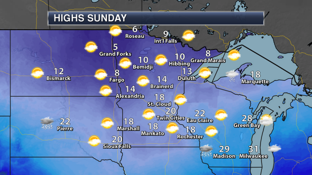
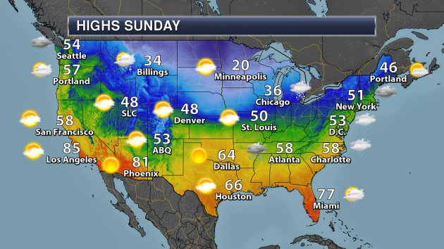
Sunday is expected be a mainly cloudy day across the state – and a cold day as well. Highs will be in the teens across most of central and southern Minnesota, with single digits expected across far northern Minnesota.
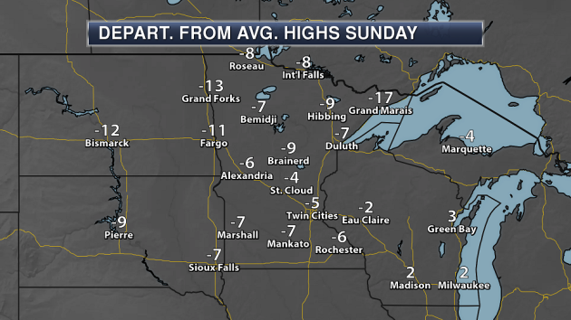
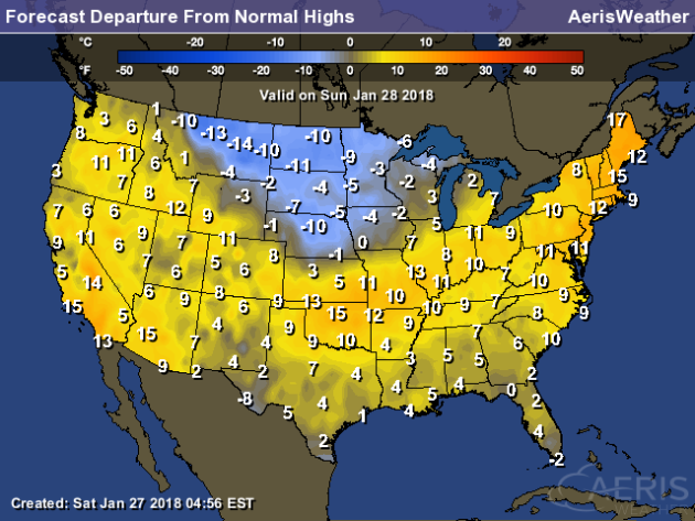
Sunday highs will be a good 5-10 degrees below average across most of the state, with the coldest departure from average values found across western and northern Minnesota.
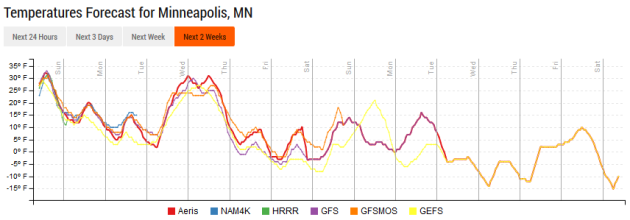
We’ll see up and down temperatures over the last few days of January, with a cold couple days followed by warmer weather Tuesday and Wednesday. The warmth won’t last, though, as another cold blast of air looks to move south of the border as we head toward the end of the week and into Super Bowl weekend.
Luckily, there are no big storms on the horizon as we head through this event-filled Super Bowl weekend. Some light snow will be possible as a system moves through the region Tuesday into Wednesday, and then more light snow is possible due to a passing clipper next weekend.
_______________________________________________
National Weather Forecast
Showers and storms are likely Sunday across parts of the east coast as a cold front continues to move east. A second cold front will be moving across the northern U.S., bringing much cooler air in as well as some areas of light snow. Rain and snow will continue across the Northwest.
While most of the nation will see highs that are near to above average Sunday, cooler than average weather will be found behind a cold front across parts of the Northern Plains into the upper Midwest.
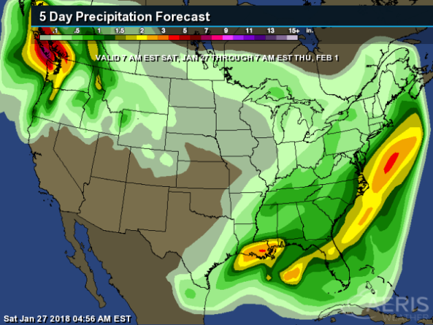
Heavy rain and mountain snow will continue over the next several days across parts of the Pacific Northwest, with 2-5”+ of liquid possible by Thursday morning. Across the east coast, precipitation will fall Sunday, but the heaviest will remain offshore. Heavy rain in the New Orleans area will continue into Sunday morning.
The heaviest snow through Tuesday morning will be across portions of the Northwest, where up to a foot is possible at higher elevations.
_______________________________________________
Boulders Can Move In Storms

Here’s something I would have never thought possible – scientists have found large boulders that actually moved during the winter of 2013-2014 in Ireland. More from Earther: “On the rocky shores of a windswept island just west of Ireland, the 620-ton boulder looks almost at home. But careful analysis of its position over the last few years has revealed something odd: between the summers of 2013 and 2014, the boulder shifted a couple meters toward the sea. That discovery is causing scientists to rethink what they know about the impacts of powerful storms.” (Image: The largest of the Very Large Boulders. Photo Courtesy Peter Cox)
Hurricane Harvey Rainfall
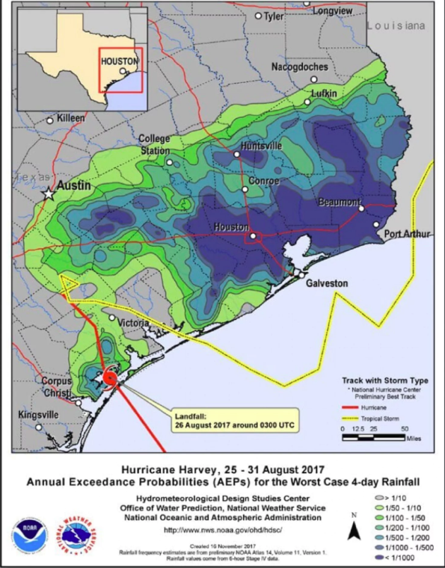
The National Hurricane Center Thursday not only confirmed that Harvey set a new tropical rain record, but that the most extreme rain associated with Harvey – rain that has only a 1 in 1,000 chance of occurring in a single year – covered an enormous area. More from the Capital Weather Gang: “Hurricane Harvey unleashed a tropical deluge probably unsurpassed in U.S. history, the National Hurricane Center says. In an in-depth meteorological review of the storm released Thursday, the center said it was unable to identify any past storm that had unloaded so much rain over such a large area.”
Drought Expanding Across Texas
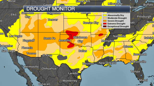
Even after all that rainfall from Harvey across *parts* of Texas, drought is expanding across the state. More from myStatesman: “No, it’s not your imagination. It’s dry out there. In fact, Texas is experiencing the most severe drought the state has seen since October 2015. Nearly half the state is in some level of drought, with an additional 35 percent experiencing abnormally dry conditions. By contrast, less than 2 percent of the state was in drought three months ago, and about 3 percent of the state had drought conditions a year ago.”
________________________________________________
Thanks for checking in and have a great Sunday! Don’t forget to follow me on Twitter (@dkayserwx) and like me on Facebook (Meteorologist D.J. Kayser)!
– D.J. Kayser

