
Safest State in the USA? You May Be Surprised
I don’t have the answer key – I rarely even know what questions to ask. But that doesn’t stop readers from reaching out. “Paul, what is the safest state in the nation to retire to?” I get this one a lot.
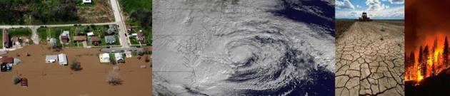
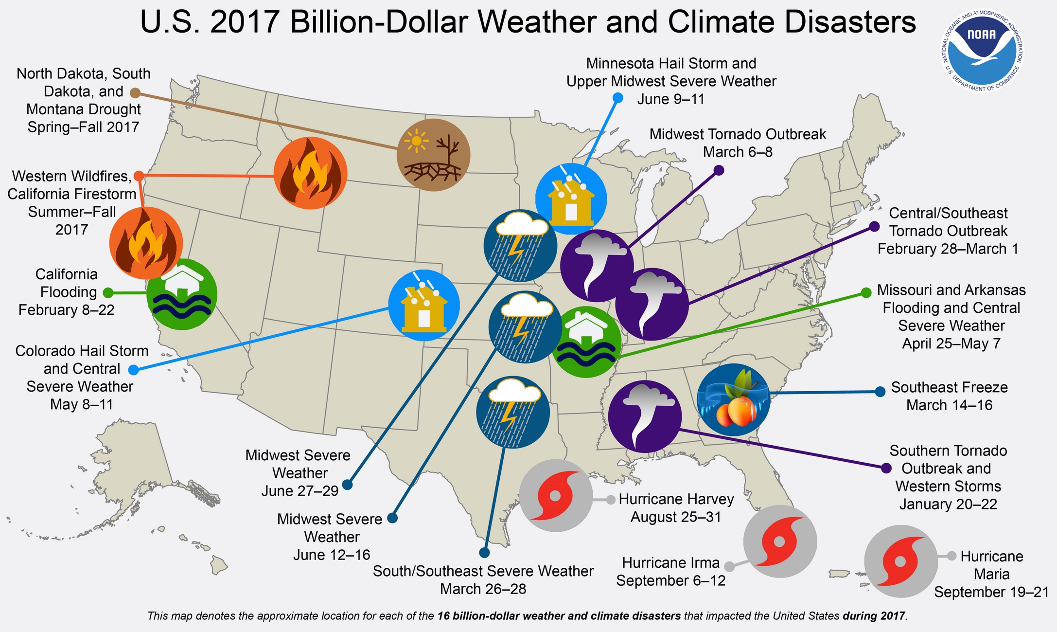
The southwestern USA is relatively safe; free from tornadoes and hurricanes. As long as you don’t mind sweating, profusely, much of the year. NOAA data shows only 22 billion-dollar weather and climate disasters in Arizona since 1980. That compares with 31 in Minnesota (mostly floods and droughts) and 95 in Texas; most in the USA. The Lonestar State hits the trifecta: hurricanes, tornadoes and floods. In general risk is higher as you approach the Gulf Coast. Safest spot: New England. Maine has only experienced 13 separate billion-dollar disasters.
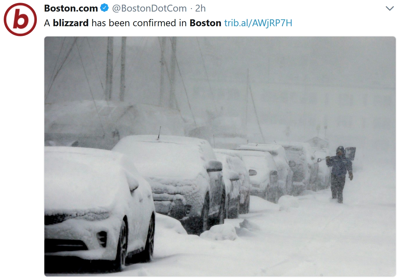
While Bostonians dig out from a blizzard I assure you there will be a welcome lack of “weather” here at home; no big storms on the horizon. 40s spill into the weekend; more incentive to lose a few layers of clothing.
NOAA data shows 1-2 inches of liquid water locked in our snow cover. A slow thaw will lessen the risk of river flooding.
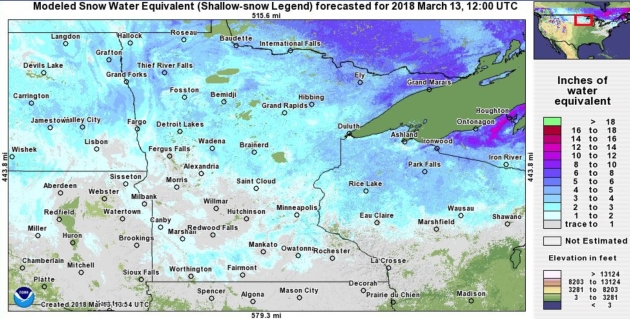
Snow Water Equivalent. There’s still about 1-2″ of water locked into the snow pack over much of Minnesota, according to NOAA – closer to 5-6″ over the North Shore.
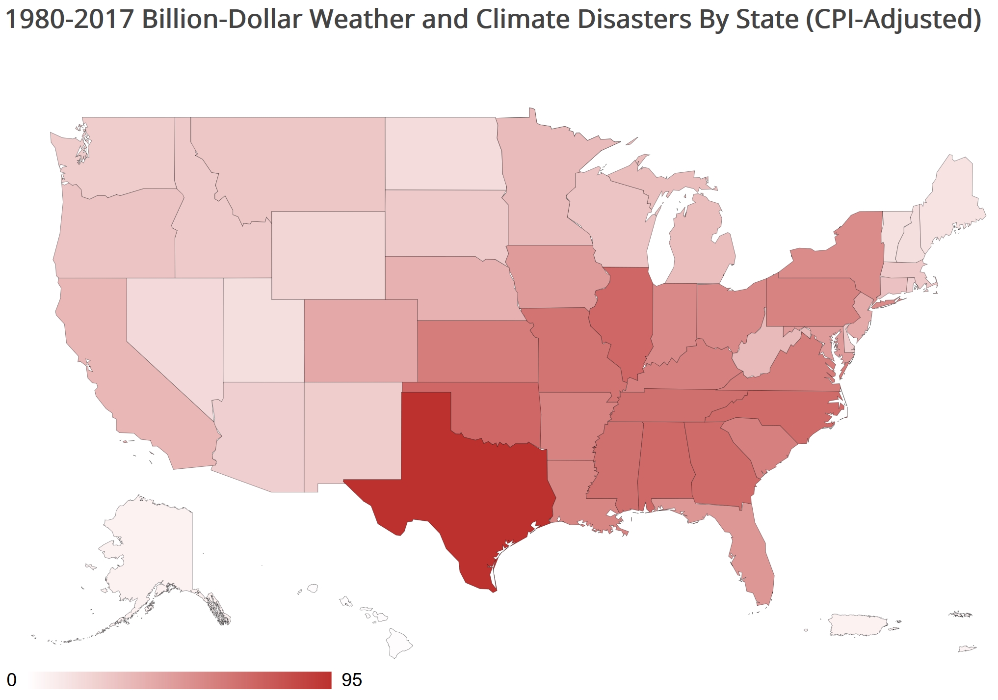
America’s Safest State is….Maine? You could make an argument for New England, based on NOAA NCEI mapping out the number of billion-dollar weather and climate disasters since 1980. Maine has experienced 13 events, 14 in Vermont and 15 in New Hampshire, compared to 31 in Minnesota and 95 in Texas: “From 1980–2017, there were 25 drought events, 28 flooding events, 8 freeze events, 91 severe storm events, 38 tropical cyclone events, 15 wildfire events, and 14 winter storm events with losses exceeding $1 billion (CPI-Adjusted) each across the United States…”
Drought and flooding has resulted in the greatest dollar losses for Minnesota. A list of the disasters from 1980 is here.
Praedictix Briefing: Issued Tuesday, March 13th, 2018:
* Heavy snow and strong winds are impacting the Northeast this morning with the third Nor’easter to impact the region within the past two weeks.
* Overall heavy snow amounts of 6-18”+ are expected from central Long Island into New England, including Boston (MA), as well as Portland, Bangor and Caribou (ME). This snow will fall at a 1-3” per hour rate, making travel difficult across the region today. Already 8” of snow has fallen in Burrillville, RI, with 6.8” falling in Framingham, MA.
* Winds are strongest near the coast with this system, and due to the heavily falling snow and strong winds Blizzard Warnings are in effect across the Massachusetts and Maine coasts, including Boston and Portland as visibilities will be reduced for an extended period of time. A 68 mph wind gust has already been reported in Woods Hole, MA. These strong winds could cause some power outages, especially with expected wet snow that will more easily cling onto power lines and tree branches.
* Minor to moderate coastal flooding at high tide is also expected with this system, especially in areas vulnerable from the previous two coastal systems. Numerous Coastal Flood Advisories and Warnings are in effect.

Winter Weather Concerns. Blizzard Warnings are in effect along the Massachusetts and Maine coasts, including in Boston and Portland as strong winds combined with the heavily falling snow will cause whiteout conditions. In these areas, winds will gust between 45-65 mph, with total snow accumulations of 12-22” likely. The heaviest snow will fall across parts of southeastern Massachusetts, including areas like Plymouth, Foxborough, New Bedford and Hyannis, where the highest probability of 18-22″ snowfall totals exist. Winter Storm Warnings continue from Long Island to northern New England for the potential of 6-18” of snow. Winter Storm Warnings are also in effect across parts of western New York for long duration moderate to heavy snow through early Thursday morning with totals of 8-22″ expected. Winter Weather Advisories are in effect elsewhere across the Northeast from parts of New Jersey and Pennsylvania northward, including New York City. Snow totals in these areas will generally be under a half a foot. For the larger cities under winter alerts this morning:
- New York City (NY) is under a Winter Weather Advisory until Noon today for 1-3” of snow.
- Boston (MA) is under a Blizzard Warning until 8 PM Tuesday for 13-20” of snow with wind gusts up to 55 mph.
- Portland (ME) is under a Blizzard Warning from 11 AM today to 2 AM Wednesday for 14-18” of snow with wind gusts to 50 mph.
- Bangor (ME) is under a Winter Storm Warning until 2 PM Wednesday for 13-17” of snow.
- Caribou (ME) is under a Winter Storm Warning from 6 PM tonight to 2 AM Thursday for 8-13” of snow.
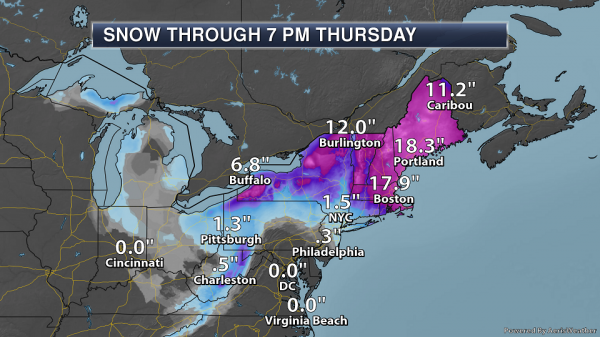
Northeast Snowfall Expected. A swath of at least a foot of snow is expected to fall from Massachusetts across New Hampshire, Vermont and Maine. The heaviest snow totals are expected from eastern Massachusetts into central Maine, where snowfall totals of 16-22” of snow are expected. The Boston metro is expected to be on the low end of that projection at the moment, but parts of southeastern Massachusetts (including Plymouth) could see the higher end of that range. In New York City, snow totals of 1-3” are expected.
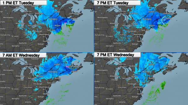
Timing The Precipitation. Snow will continue to spread across New England today, with heavy snow continuing to fall in Boston throughout the day. By this evening, heavy snow will be falling across most of Maine, with snow slowly starting to taper off in Boston through the overnight hours. Moderate to heavy snow will continue across parts of the Northeast into Wednesday, with additional lighter wrap-around snow showers possible for New York City and Boston tomorrow.

Expected Peak Tuesday Wind Gusts. Strong wind gusts (40 mph+) with this coastal low are expected near the coast, from eastern Long Island across Rhode Island, eastern Massachusetts and along the Maine coast. The strongest wind gusts – up to 65 mph – will continue to be possible in parts of southeastern Massachusetts, including in areas like Cape Cod and Martha’s Vineyard, throughout the day. This would have the potential of causing power outages across the region, especially in places that have been hard hit by the previous coastal storms. These strong winds will also create whiteout conditions over an extended period of time, which is why Blizzard Warnings are in effect along the Massachusetts and Maine coasts.
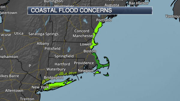
Coastal Flood Concerns. Mainly minor to moderate coastal flooding is expected along the coast, especially during high tide this morning, from Long Island to southern Maine. Areas of inundation up to 1-2 feet are possible, especially in areas that have been made vulnerable by the past two coastal storms.
Summary. The third high impact Nor’easter in two weeks will continue to affect the Northeast as we go through the middle of the week. Already snow totals over a half a foot and wind gusts approaching 70 mph have been reported across parts of the Northeast. Moderate to heavy snow will continue today across New England, with at least 6” of snow expected to fall from central Long Island into Maine. The heaviest totals will fall from eastern Massachusetts into central Maine, where snowfall totals of 16-22” of snow are expected, including in Boston. This heavy snow, combined with gusty winds of 40-65 mph along the Massachusetts and Maine coasts, will cause blizzard conditions throughout the day. Blizzard Warnings are in effect due to this potential. These strong winds and heavy snow will have major impacts on travel, especially during the height of the system, and could cause power outages. Minor to moderate high tide coastal flooding is also expected with this system today and tonight, especially in areas vulnerable from the previous two coastal systems.
D.J. Kayser, Meteorologist, Praedictix
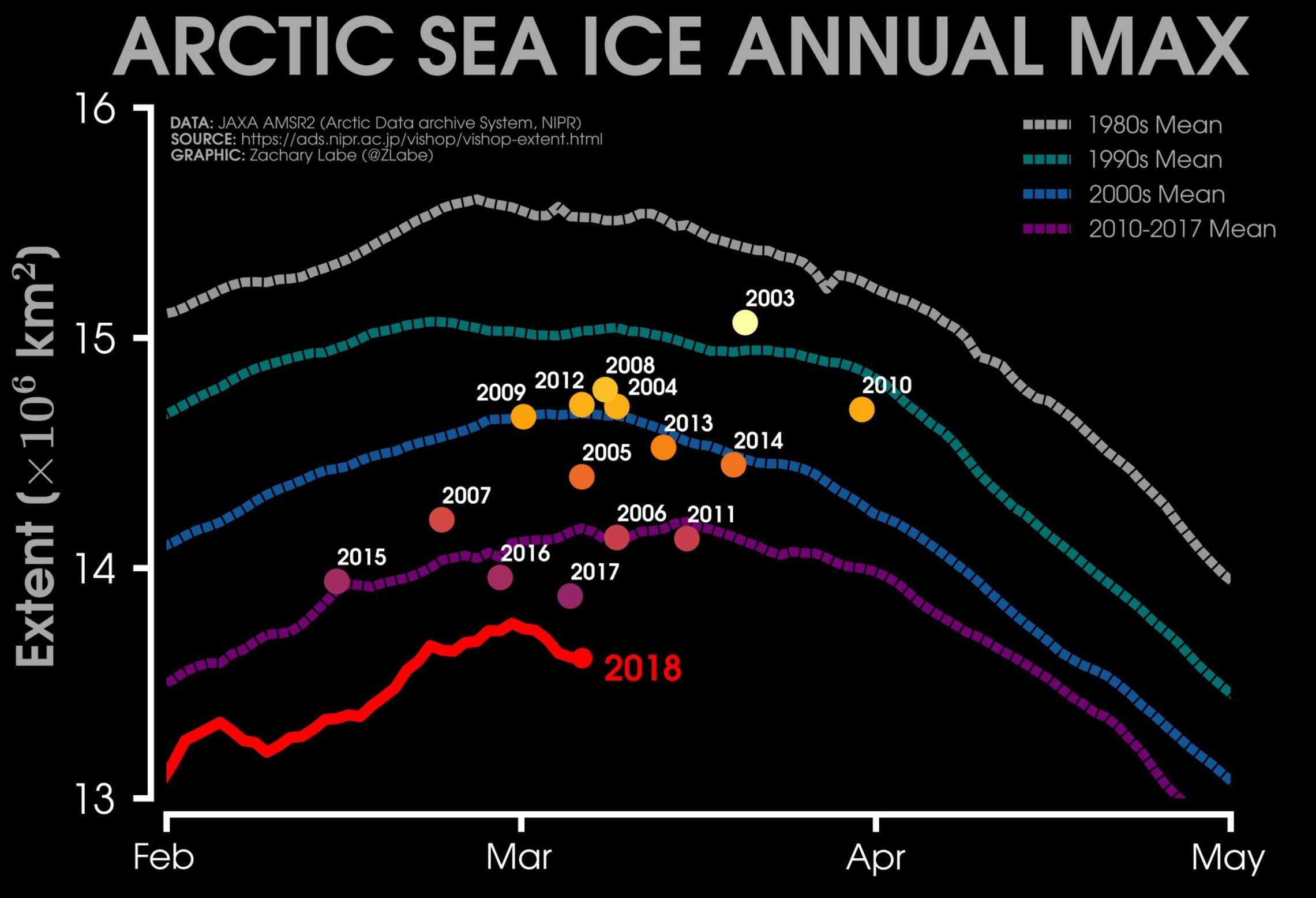
Arctic Has Warmest Winter with Sea Ice at Record Lows. Here’s an excerpt of a post at Insurance Journal: “…Scientists say what’s happening is unprecedented, part of a global warming-driven vicious cycle that likely plays a role in strong, icy storms in Europe and the U.S. Northeast. “It’s just crazy, crazy stuff,” said Mark Serreze, director of the National Snow and Ice Data Center in Boulder, Colorado, who has been studying the Arctic since 1982. “These heat waves, I’ve never seen anything like this.” It’s been so unusually warm that the land weather station closest to the North Pole – at the tip of Greenland – spent more than 60 hours above freezing in February. Before this year, scientists had seen the temperature there rise above freezing in February only twice before, and only ever so briefly. Last month’s record-hot temperatures at Cape Morris Jesup have been more like those in May, said Ruth Mottram, a climate scientist at the Danish Meteorological Institute...”
The Toughest Places to Forecast Weather in the U.S.? Every meteorologists (sincerely) believes that his or her hometown is toughest in the nation. Really. John Erdman makes the case for a few specific regions in a post at Weather Underground; here’s a clip: “…Nothing can be more pressure-packed than the potential for a high-impact snowstorm in the heavily populated Northeast Megalopolis, home to more than 50 million. “Meteorologically, the I-95 corridor will always be a winter weather challenge as it is almost always the battleground between snow, ice, rain,” said Gary Szatkowski, retired former meteorologist-in-charge of the National Weather Service office in Mount Holly, New Jersey, near Philadelphia. Szatkowski issued an apology after an expected heavy snowstorm, Winter Storm Juno, missed Philadelphia but clobbered other parts of the Northeast, in particular, New England, in late January 2015. “The meteorologist has to draw those lines somewhere, and they won’t be perfect,” Szatkowski said. “Small changes in timing and location of weather events can have huge changes in the impacts. That’s the nature of the beast, here…”
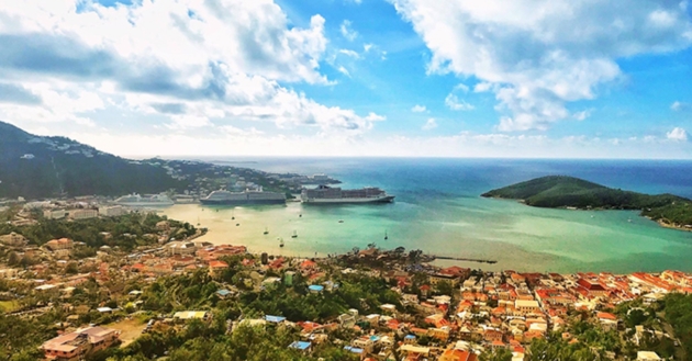
How Caribbean Cruise Ports are Focusing on Hurricane Preparedness. Cruise Critic takes a look at some of the ports hit hardest by Irma and Maria in 2017: “…The Caribbean is open; steadfast relief efforts brought the islands back to their feet in merely a few months, and in some cases, weeks. Countless cruise lines — including Royal Caribbean, Norwegian Cruise Line, Carnival Cruise Line and MSC Cruises — delivered supplies to those in need, in addition to making financial contributions. While these islands are still in the process of recovering in many ways, they are stronger than ever; already making preparations in the event that another major storm — like the pair from last September — takes aim at the region. “As we look at the next year, the next two years… some of our properties had significant devastation, but we’re looking at, ‘How do we make this property better? How can we build stronger?,'” Beverly Nicholson-Doty, U.S. Virgin Islands’ commissioner of tourism, told Cruise Critic in an exclusive interview…”

What is Cloud Seeding, and Does It Really Work? Here’s an excerpt of an informative post at Mother Nature Network: “Controlling the weather is a popular bit of science fiction. Be it Storm’s powers in the X-Men franchises, or high-tech satellites in movies like “Geostorm” or the 1998 film “The Avengers,” in which Sean Connery plays a mad scientist bent on holding the world hostage by selling countries their weather. In reality, controlling the weather is impossible. We can, however, influence it, and we’ve been attempting to do it for some time. Various efforts, from hail cannons to stopping hurricanes, have been tried or proposed over the years, to say nothing of the incidental effect of our use of fossil fuels. Perhaps the most popular attempt at geo-engineering, however, is cloud seeding...”
Photo credit: “Cloud seeding is a process of aiming chemicals into clouds to induce more rain and snow to fall.” (Photo: Eugene Shwab/Shutterstock).
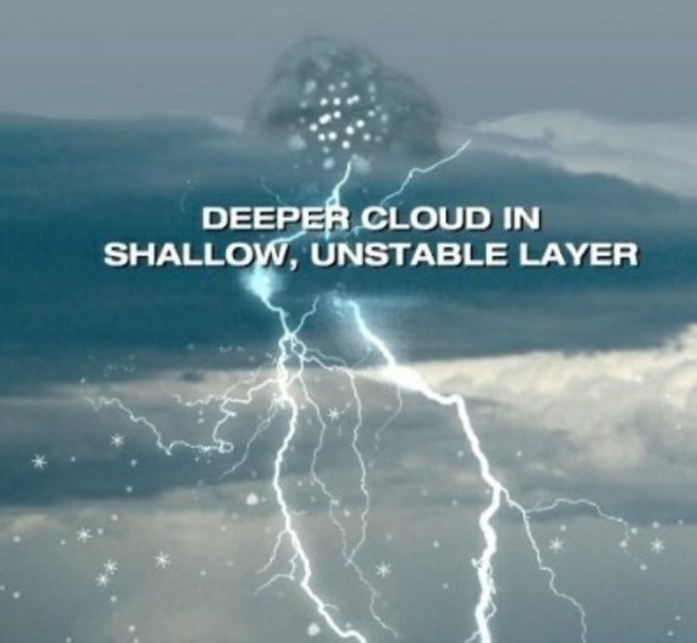
How Thundersnow Actually Happens. Dr. Greg Forbes explains in a post at Weather Underground: “…When the air above the initial cloud layer is relatively cool and dry, and when the added cooling and lifting is strong, a shallow layer just above the original flat cloud can become unstable. This makes it favorable for “elevated convection” – showers or thunderstorms. The rising turret is the result, containing vigorous upward and also some downward motions. There is usually more than one turret that forms in these conditions. There can be bands or a checkerboard pattern of turrets present. When the unstable layer develops where the temperature is about -10 to -20 degrees Celsius (+14 to -4 degrees Fahrenheit), conditions are favorable for both snowflakes and small hailstones (called graupel) to form…”
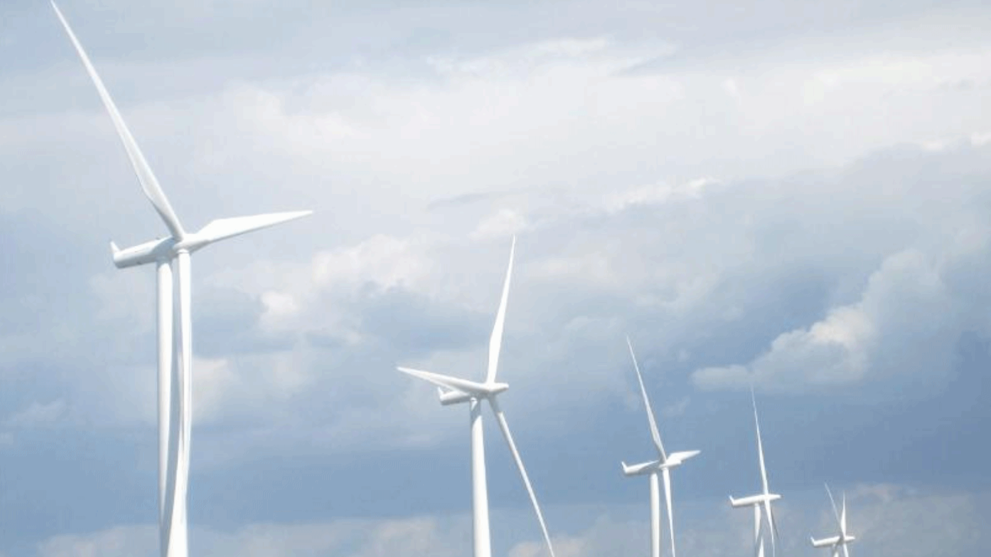
Minnesota is in the Midst of a Massive and Historic Energy Transformation. Here’s a clip from a story at MinnPost: “…It is important to note that these trends and economic benefits are expanding throughout the state – especially to our rural communities. According to the 2017 Clean Jobs Midwest report, Greater Minnesota is home to more than 17,000 clean energy jobs, representing 30 percent of the state’s total clean energy workforce. Energy efficiency improvements, along with investments into wind and solar, are spurring rural economic development, reducing energy costs, and providing important tax revenue to communities across the state. In the last year alone, Minnesota added 467 megawatts (MW) of solar capacity — enough to power 53,000 homes and nearly tripling the capacity added in 2016. This growth was also accompanied by an exceptional 48 percent increase in solar industry jobs as found in The Solar Foundation’s latest Solar Jobs Census...”
File image: AP.

Arnold to Big Oil: Screw You: From Climate Nexus: “Arnold Schwarzenegger says he plans to sue oil companies for “knowingly killing people all over the world.” In a Monday interview with Politico’s Off Message podcast, the former governor of California says he is still working on a timeline and details for filing. “To me it’s absolutely irresponsible to know that your product is killing people and not have a warning label on it, like tobacco,” Schwarzenegger told Politico. “Every gas station on it, every car should have a warning label on it, every product that has fossil fuels should have a warning label on it…If you walk into a room and you know you’re going to kill someone, it’s first degree murder; I think it’s the same thing with the oil companies.” (Politico, The Hill)


Even a Little Light In Your Bedroom at Night Can Heighten Depression. Big Think explains: “Sleeping with even a little bit of light in your bedroom at night can heighten depression, says a new study from the American Journal of Epidemiology. Even when other factors were taken into consideration — like whether the patients smoked, ate poorly, etc — this increase in light in the bedroom accounted for a big jump in depression. 900 elderly Japanese patients were studied over the course of 2 years and it was found that those with over 5 lux had a higher chance of developing depression by 60-65%. Out of the 900 people in the study, just 150 of those slept in rooms with more than 5 lux…”
Photo credit: Wikicommons: Japanexperterna.

Menu of the Future: Insects, Weeds and Bleeding Veggie Burgers. I predict I may lose weight – finally – and against my will. National Geographic reports: “Peer into the future of what we eat, and you will encounter many questions about what will happen to our meals. As the world’s population climbs above 9 billion by mid-century, our food needs will grow by 70 percent. How do we meet them without mowing down every forest or without resorting to industrial agriculture, which the United Nations Food and Agriculture Organization has cited as the most significant contributor to climate change? How do we maintain soil health, and keep it from washing away, so that crops can thrive? These questions get into murky territory. But here’s one thing that’s clear: Dinner in 50 years won’t look much like dinner today…”
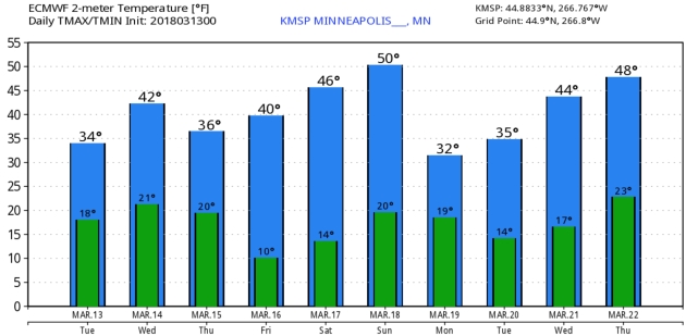
2″ snow left on the ground at MSP International Airport.
37 F. high yesterday in the Twin Cities.
40 F. average high on March 13.
27 F. high on March 13, 2017.
March 14, 1943: Snow, sleet and ice cripple parts of Minnesota south of a line from Duluth through St. Cloud and Ortonville. The heaviest ice was in the vicinities of Lake Benton, Springfield and Windom. Ice thickness was 1/2 to 3/4 inch around St. Cloud to 3/4 to 2 inches in the Pipestone, Ruthton, Lake Wilson, Slayton and Tracy. A good description of the ice was submitted in one report: ‘…ice was 2 inches across and 1 3/4 inch deep on wire. A little frost ice near the wire with the outside solid ice. The ice was irregular in shape.’ Duluth had 6 inches of snowfall at the city office with 13 inches at the airport. The ice was confined to Moose Lake and south.
March 14, 1870: A severe snow and wind storm moves across Minnesota and Iowa. The ‘Northern Vindicator’ of Estherville, Iowa becomes the first newspaper to use the term ‘blizzard’ on this date.
WEDNESDAY: Sunny and milder. Winds: W 8-13. High: 44
WEDNESDAY NIGHT: Mostly clear. Low: 24
THURSDAY: Blue sky, few degrees cooler. Winds: NE 5-10. High: 41
FRIDAY: Bright sun, fairly pleasant. Winds: E 5-10. Wake-up: 22. High: 42
SATURDAY: Plenty of sun, hints of spring. Winds: NW 5-10. Wake-up: 23. High: 46
SUNDAY: Sunshine lingers, above average temps. Winds: NE 5-10. Wake-up: 26. High: 48
MONDAY: Light mix far southern Minnesota? Winds: NE 8-13. Wake-up: 31. High: 39
TUESDAY: Sunshine returns, seasonable. Winds: NE 5-10. Wake-up: 25. High: 41
Climate Stories…
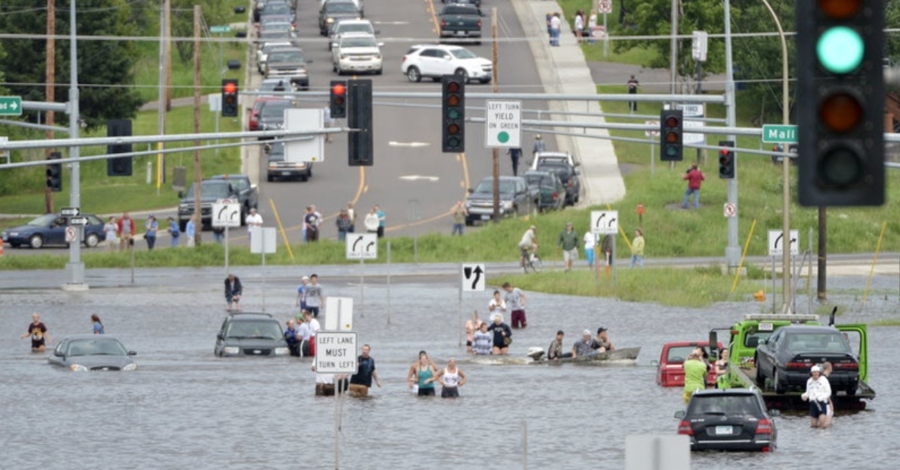
With the EPA AWOL, Minnesota Cities Prepare for Climate Change Alone. Here’s an excerpt from City Pages: “…Across the state, cities are readying themselves for the dangers of climate change and working to shrink their carbon footprints. But making a city more resilient is costly, and efforts to reduce emissions can seem paltry compared to the scale of the problem they’re trying to solve. Climate change is expected to increase the frequency and intensity of rainfall in Minnesota, bringing with it a greater risk of flash flooding that threatens cities whose current infrastructure has never weathered a 100- or 500-year flood. Since 2000, the state has had eight “mega-rain events,” when at least six inches of rain fell in an area greater than 1,000 square miles, according to the Minnesota Department of Natural Resources. There were only three in the 30 years between 1970 and 1999…”
File photo credit: “Duluth’s 2012 flooding at least helped teach the city what it wasn’t prepared for.” Associated Press.
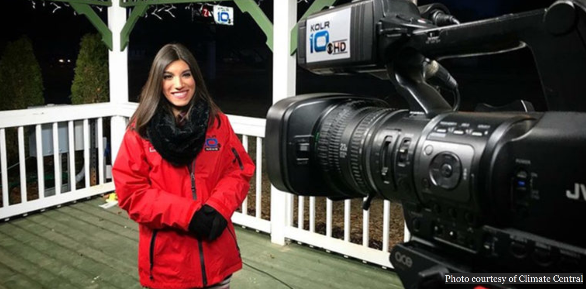
Why TV Meteorologists are Talking About Beer, Chocolate, Peaches and Poison Ivy. More TV meteorologists are connecting the dots when it comes to climate volatility and weather disruption. Ensia reports: “…For years, TV meteorologists were hesitant to talk about climate change. Climatological views — the long-term trends and patterns that influence weather — were not part of their education. Their time on air is limited. Some stations may discourage climate change talk. Many meteorologists simply feel it isn’t their responsibility. And some are concerned about how it might affect their ratings and job security. “Audiences trust their local meteorologists,” says Mike Nelson, chief meteorologist at Denver7, an ABC affiliate in Colorado. “Our jobs depend on that trust. Meteorologists understand this, and some tend to stay away from controversial subjects.” But that won’t do anymore, says Nelson. “We are as close to a scientist as most Americans will ever get. People invite us into their living rooms. We have a responsibility to educate them on the facts...”
File image: Climate Central.
Melting Glaciers Do More Than Raise Sea Levels. Some interesting perspective from Hakai Magazine: “…Glaciers, like many venerable objects, can act as time capsules. Like a dusty vinyl record holds an era’s songs, ice holds very old molecules—not just the H2O of snow, but traces of airborne particles like dust, ash, and chemicals that hitched a ride on falling flakes. In the Antarctic, Adélie penguins harbor consistent levels of the pesticide DDT even though it’s been widely banned since the 1970s. The source: glacier meltwater that trickles past the penguins on its way to the sea, eventually making its way into the penguins’ food webs. That means at least some of the ice now melting inland was once snow that fell before DDT was restricted in the 1970s. Many other once-airborne and now-banned pollutants are reappearing in glacier meltwater, such as PCBs and CFCs, the latter of which were a component of hairspray and other aerosols until they were phased out in the 1980s...”
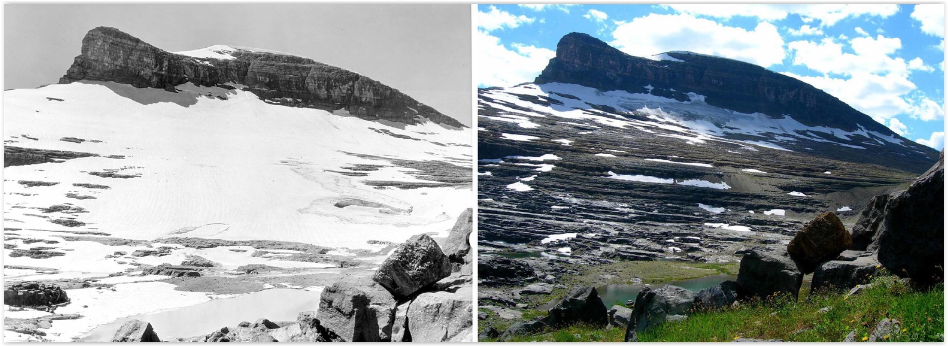
Image credit: Boulder Glacier, Montana, from 1932 to 2005. Source: USGS.
As Urgency Mounts, Worry Among Climate Scientists Gets Personal. Here’s an excerpt from Reuters: “When marchers took to the streets of Washington in a pro-science demonstration after U.S. President Donald Trump’s election, it was the first time climate scientist Cynthia Rosenzweig put on an activist hat. Rosenzweig, who works for the National Aeronautics and Space Administration, has spent decades researching and warning about the dangers of global warming, from punishing floods to drought. But fears that policy-makers may ignore science and cut funding for research has had her and many like her struggling to balance scientific detachment with the urgency of their findings. They say they worry that scepticism about climate change is diluting the gravity of their discoveries and losing the attention of the next generation of researchers. Tens of thousands of people, including Rosenzweig and other scientists swapped lab coats for protest signs, joined the March for Science last April…”
Burning Coal May Have Caused Earth’s Worst Mass Extinction. Here’s an excerpt from a story at The Guardian: “…Previous research has shown that the Permian mass extinction event didn’t coincide with the start of the Siberian volcanic eruptions and lava flows, but rather 300,000 years later. That’s when the lava began to inject as sheets of magma underground, where Burger’s data suggests it ignited coal deposits. The coal ignition triggered the series of events that led to Earth’s worst mass extinction. Its sulfur emissions created the acid rain that killed forests. Its carbon emissions acidified the oceans and warmed the planet, killing most marine life. The dead bodies fed bacteria that produced toxic hydrogen sulfide gas, which in turn killed off more species. The warming of the oceans produced a large methane release, which accelerated global warming faster yet...”
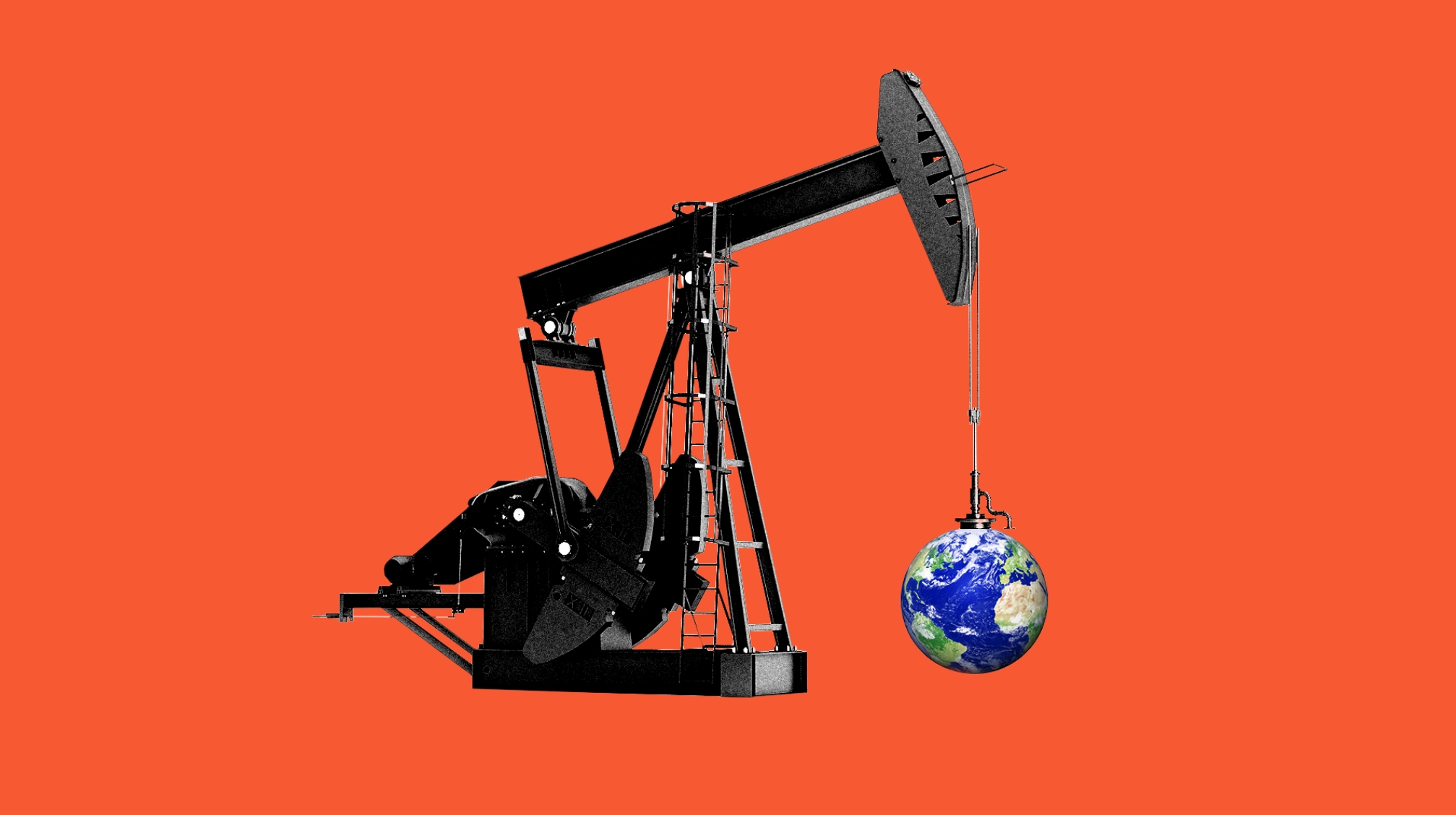
The Oily Path to Tackling Climate Change. Axios has more details on additional tax incentives to encourage carbon capture: “On the outskirts of America’s oil capital is a carbon capture project poised to reap hundreds of millions of dollars in new federal tax credits. There’s a catch, though: it uses the carbon to extract oil.Why it matters: Capturing carbon to extract oil seems counterintuitive to addressing climate change, but experts who have crunched the numbers say this technology is a necessary, if controversial, step that’s helped along by these kinds of projects. A new report by the International Energy Agency shared exclusively with Axios that is being released today finds a provision in the recently passed budget bill is poised to drive a record amount of investment to carbon capture…”
Illustration credit: Rebecca Zisser / Axios.
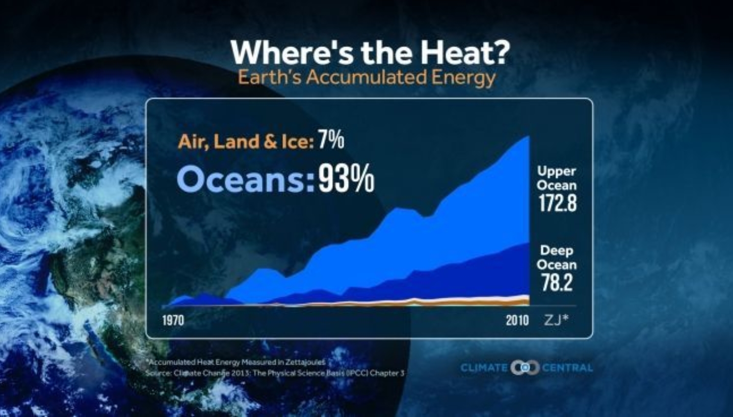
OCEANS: Headlines and links via Climate Nexus: “This dire ocean scenario is a stark reminder of why the world is trying to stop climate change (Washington Post $), Paris of the oceans’ pact crucial to save seas, says WWF head (Reuters), Brazil protecting vast sea areas in bid to safeguard biodiversity (Reuters), Scott Walker pulls request for marine sanctuary after Trump review.” (The Hill)