
.gif)
.gif)
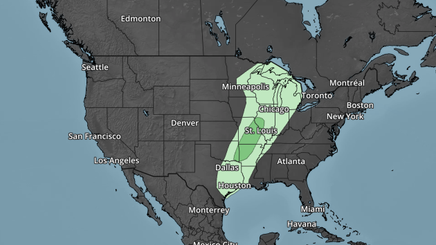
According to NOAA’s WPC, the 5 day precipitation outlook suggests areas of heavier precipitation pushing in across parts of the eastern half of the country through the end of the week. Note that there appears to be fairly widespread 1″+ tallies across the Gulf Coast States into the Eastern Seaboard and also across the Great Lakes. There may also be some heaiver tallies across the Intermountain West, where snow will be found there.
 ___________________________________________________________
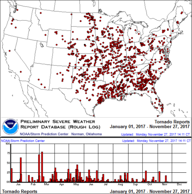
It certainly has been a fairly active first half of 2017 with 1,509 preliminary tornado reports through December 2nd. Note that this is the most tornadoes through that date since 2011, when there were 1,880 reports. The map below shows the distribution of the tornadoes so far this year.
PRELIMINARY 2017 Tornado Count
According to NOAA’s SPC, the PRELIMINARY 2017 tornado count is 1,509 (through December 2nd). Note that is the most active year for tornadoes since 2011, when there were 1,880 tornadoes. Notice that the only other year with more tornadoes than this year was in 2008, which ended with a whopping 2,140 tornadoes nationwide.
.png)
_____________________________________________________________________
National Weather Hazards Ahead…
1.) Heavy rain for parts of the northern Great Lakes, Mon, Dec 4.
2.) Heavy rain for parts of the Lower Mississippi, Tennessee, and Ohio Valleys, southeast, and southern Appalachians, Mon-Tue, Dec 4-5.
3.) Heavy rain for parts of the Mid-Atlantic and Northeast, Tue, Dec 5.
Heavy precipitation for parts of southeastern mainland Alaska and the Alaska Panhandle, Tue-Wed, Dec 5-6.
4.) High significant wave heights for parts of the Alaska Peninsula and south coastal mainland Alaska, Mon, Dec 4.
5.) Periods of high winds for parts of the Aleutians, Alaska Peninsula, south coastal mainland Alaska, and the Alaska Panhandle, Mon-Fri, Dec 4-8.
6.) High winds for parts of the northwest arctic coast of mainland Alaska, Mon-Tue, Dec 4-5.
7.) Periods of heavy lake effect snow for parts of the Great Lakes, Sat-Mon, Dec 9-11.
8.) Slight risk of much below normal temperatures for much of the east-central and eastern CONUS, Sat-Fri, Dec 9-15.
9.) Moderate risk of much below normal temperatures for parts of the Great Lakes, central Appalachians, and Mid-Atlantic, Mon-Thu, Dec 11-14.
10.) Severe Drought across the Lower Mississippi Valley, the Northern Plains, Hawaii, the Northern Rockies, the Middle Mississippi Valley, the Southern Plains, and the Southwest.
.png)
_____________________________________________________________________
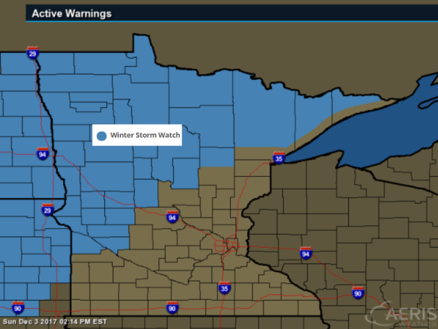
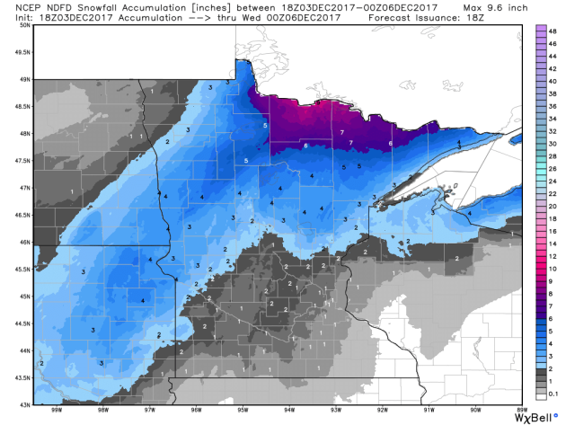
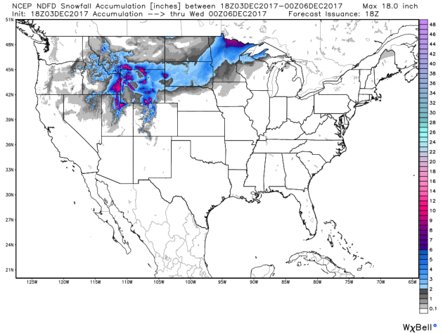
By Todd Nelson, filling in for Douglas.Well, here we go! Are you ready for Winter? We rode off into sublime November sunset, but reality will set in today as a fairly potent cold front blasts through the region.Blizzard warnings have been posted across far western Minnesota in advance of a shovelable snow and 50mph+ wind gusts that could create whiteout conditions there. The heaviest snow will fall across far northern Minnesota with as much as 8 to 12 inches possible by Tuesday morning!
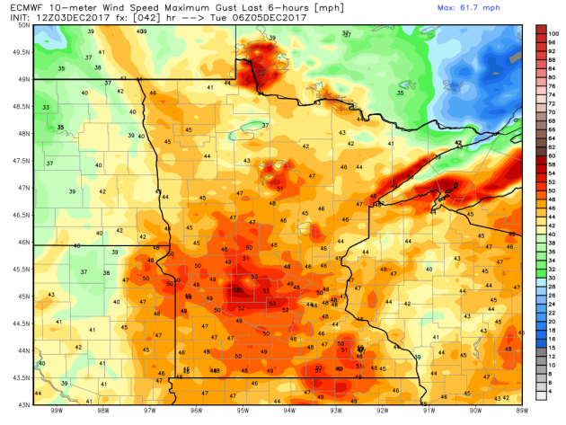
The Twin Cities will start off with a little rain early Monday, but will turn to snow later in the day and could see as much as 1 to 2″ by the Tuesday morning commute. The bigger story will be the drastically colder air riding in on tropical storm force winds overnight Monday as winds gust up close to 50mph. It’ll be a window rattling night tonight no question!
Sure, this storm won’t be a major snow producer for the southern half of the state, but it will bring some of the coldest air of the season. Temps will be more reminiscent of January over the next several days. Bundle up!
________________________________________________________________________
Extended Forecast
This Day in Weather History
December 4th
1886: Minneapolis hits a record-setting 15 degrees below zero.
________________________________________________________
Average High/Low for Minneapolis
December 4th
Average High: 31F (Record: 56F set in 1941)
Average Low: 16F (Record: -15F set in 1886)
Record Rainfall: 0.58″ set in 1887
Record Snowfall: 4.2″ set in 1947
_________________________________________________________
Sunrise/Sunset Times for Minneapolis
December 4th
Sunrise: 7:34am
Sunset: 4:32pm
Hours of Daylight: ~8 hours 57 mins
Daylight LOST since yesterday: ~1 minutes and 19 seconds
Daylight LOST since summer solstice (June 20th): 6 hours & 40 minutes
__________________________________________________________
Moon Phase for December 4th at Midnight
1.6 Days After Full “Cold” Moon
Dec. 3, 9:47 a.m. CST – Full Cold Moon. On occasion, this moon was also called the Moon before Yule. December is also the month in which the winter cold fastens its grip. Sometimes this moon is referred to as the Full Long Nights Moon — a fitting name, since nights are longer at this time of year, and the moon appears above the horizon for a long time. This particular full moon makes its highest arc across the sky on this day because that’s when it appears diametrically opposite to the low sun. The moon will also arrive at perigee about 17 hours later, at 4:00 a.m. EST on Dec. 4, at a distance of 222,135 miles (357,492 kilometers) from Earth. This will be the biggest full moon of 2017 and the only “supermoon” of the year. Very high ocean tidescan be expected during the next two or three days, thanks to the coincidence of perigee with full moon.
.gif)
_________________________
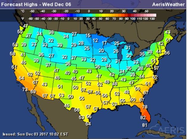
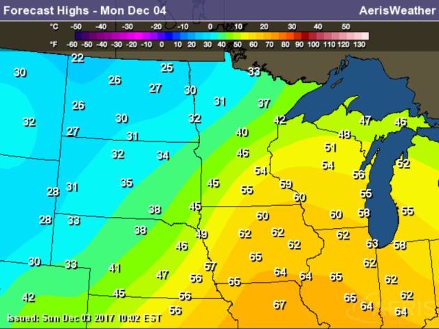
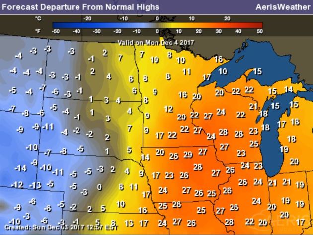
Monday will be a day of very big changes with temperatures falling throughout much of the day. Here’s a look at high temps, which will likely occur early in the day as temps tumble quickly in the wake of the front.
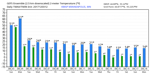
Here’s the temperature outlook through December 18th, which shows a MUCH colder temperature outlook as we head through the first half of the month. Temperatures will only warm into the 10s and 20s, which will be below average Keep in mind that the average high by December 18th is 26F and the average low is 11F.
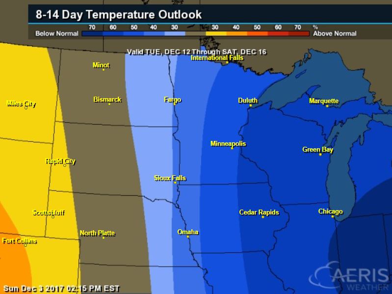
8 to 14 Day Temperature Outlook
Here’s the temperature outlook from through the first half of December, which shows that temperatures will be below average across much of the Great Lakes and Midwest.
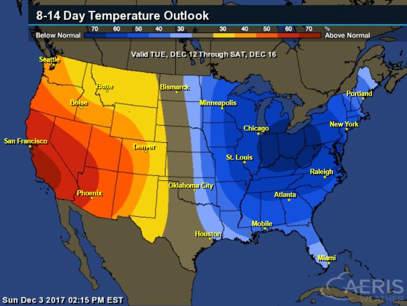
8 to 14 Day Temperature Outlook
Here’s the extended temperature outlook as we head into the middle part of the month, which shows that temperatures will be split depending on where you are in the nation. The eastern half of the nation will remain well below average, while the western half of the nation will be well above average!
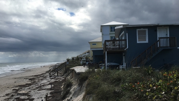
“One small Florida city tries to adapt to climate change, mostly alone”
“In a tranquil lagoon on Florida’s east coast, Harold Wanless and Lynn Bauer catch sight of a manatee swimming just a few feet away from them. The couple has driven up for the day from their home in South Florida to the small city of Satellite Beach, just south of Cape Canaveral, and watch with delight as the almost motionless manatee is joined by a sea turtle, and then another. Bauer and Wanless are visitors to Satellite Beach, but they can’t help imagining what it would be like to live in a place this magical. “It’s lovely here,” Wanless says. “What a great place to live.” Except, not all is as idyllic here as it seems. “You have to understand that when you get a storm surge of 10 feet, 12 feet, your first floor is going to be almost entirely under water,” Wanless says, pointing to homes sitting right on the lagoon’s edge. “You have to understand that king tides and heavy rainfalls are going to flood your areas.” Wanless knows what he’s talking about. He’s the chairman of the Geology Department at the University of Miami, and a leading expert on climate change and sea level rise.”
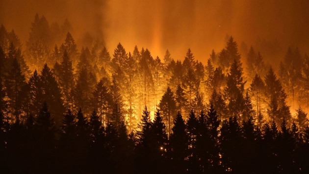
________________________________________________________________________“As Western governors gather, wildfires and disasters are a big part of the agenda”
“The Bearskin fire burned nearly 30,000 acres in Idaho. The Chetco Bar fire torched 191,000 acres near the Oregon coast. The Lodgepole Complex fire, the largest of 2017, ignited 270,000 acres in Montana. And in Northern California this fall, fast-moving fires killed at least 44 people. As wildfires — deadly, destructive, depressing — continue to wreak havoc across the West, governors and local elected officials are trying to work together to combat them. On Friday, that collaboration was on display at the Western Governors’ Assn. conference in Phoenix as leaders of states ravaged by wildfires — red states and blue states alike — discussed ways to prevent future destruction by working with one another and the federal government.”
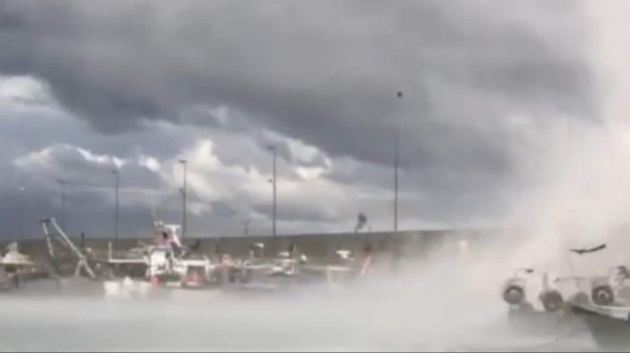
____________________________________________________________________________“Enormous waterspout forms off Italian coast before tornado hits”
“Dramatic footage shows a whirling waterspout forming off the Italian coast before making its way inland. The weather phenomenon was captured in the north-western Italian city of Sanremo, on the Mediterranean coast, on 1 December. It caused damage to central and western parts of the city and the Old Port area, but reports say that no one was seriously injured.”
See the video from Telegraph.co.uk HERE:
__________________________________________________________________________“The Upcoming December “Drought” in the Northwest”
“Precipitation will end over the Northwest on Sunday and we might not see another drop for over a week. Maybe more. An unusual occurrence in December. You will see sun….but as we will note there is a threat: low clouds and fog. Let’s take a look at the forecast upper level (500 hPa) maps this week from the NOAA GFS model…and be prepared to have your jaw drop! At 10 AM Sunday, a trough has moved passed us and a ridge of high pressure has started to build in the eastern Pacific. The rain will be ending at this time.”
See more from Cliff Masters Weather Blog HERE:
_________________________________________________________________________“Solar panel prices plunge by a shocking 26 percent in one year”
“Prices for new wind and solar plants continue to plunge at an astonishing pace. Driven by steadily improving technology and the use of auctions to set prices, the cost of solar and wind dropped 25 percent this past year — and even more in some key emerging markets like China, according to Bloomberg New Energy Finance data. That drop comes on top of an 80 percent reduction in the previous 10 years, which is why building new renewable energy sources is now cheaper than just running old coal and nuclear plants, as a new analysis recently detailed. “China’s electricity price on a solar deal for Inner Mongolia plunged 44 percent last year,” Bloomberg reported Monday. And solar module prices dropped 26 percent (see top chart from BNEF). As a result, China is on track to deploy a staggering 54 gigawatts of solar in 2017, more than any country had ever previously deployed in a single year. China recently doubled its 2020 solar goal — from 105 GW to 213 GW. That would, as Greenpeace notes, give China five times more solar capacity than the U.S. currently has.”
See more from ThinkProgress HERE:
_______________________________________________________________________________Thanks for checking in and don’t forget to follow me on Twitter @TNelsonWX

